Bridge Statistics for Beckett Ridge, Ohio (OH)
Condition, Traffic, Stress, Structural Evaluation, Project Costs
- National Bridge Inventory (NBI) Statistics
- 43Number of bridges
- 433ft / 132mTotal length
- 871,302Total average daily traffic
- 115,710Total average daily truck traffic
- National Bridge Inventory (NBI) Registered Bridges for Beckett Ridge
- No street view available for this location
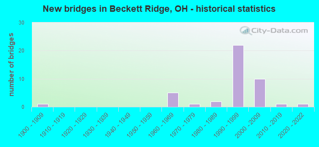
- New bridges - historical statistics
- 11900-1909
- 51960-1969
- 11970-1979
- 21980-1989
- 221990-1999
- 102000-2009
- 12010-2019
- 12020-2022


- Bridge Condition - Deck
- 17.4%Very good
- 69.6%Good
- 13.0%Satisfactory

- Bridge Condition - Superstructure
- 13.0%Excellent
- 47.8%Very good
- 30.4%Good
- 8.7%Satisfactory

- Bridge Condition - Substructure
- 17.4%Very good
- 73.9%Good
- 4.3%Satisfactory
- 4.3%Poor

- Bridge Condition - Channel
- 22.7%Excellent
- 36.4%Good
- 22.7%Satisfactory
- 9.1%Fair
- 9.1%Poor

- Bridge Condition - Culverts
- 9.1%Excellent
- 45.5%Very good
- 36.4%Good
- 9.1%Fair
Find on map >> Show street view
Structure Number: 901571, Location: .6 M S OF UNOIN CNTR BLVD (Lat: 39.314800, Lng: -84.430881), Route carried "on" structure: County highway 126, Year Built: 2004, Status: Open, Structure Length: 11.00m (36.09ft), Average Daily Traffic: 16,382 (year 2016), Truck Traffic: 1%, Average Future Daily Traffic: 22,738 (year 2036), Design Load: HL 93, Features Intersected: IR-75
Minimum Vertical Clearance: 30+ m (98+ ft), Kilometerpoint: 1.558, Lanes on structure: 2, Lanes under structure: 8, Owner: State Highway Agency, Approaching Roadway Width: 12.0m (39.4ft), Skew: 1 degrees, Material/Design: Steel continuous, Design/Construction: Stringer/Multi-beam, Number Of Spans In Main Unit: 2, Length of Maximum Span: 54.7m (179.5ft), Curb-To-Curb Width: 13.2m (43.3ft), Out-to-Out Width: 14.1m (46.3ft)
Condition: Deck: Good, Superstructure: Very good, Substructure: Good, Operating Rating: 29.2 metric tons, Method Used To Determine Operating Rating: Load and Resistance Factor Rating (LRFR) rating reported by rating factor(RF) method using HL-93 loadings, Inventory Rating: 22.7 metric tons, Method Used To Determine Inventory Rating: Load and Resistance Factor Rating (LRFR) rating reported by rating factor(RF) method using HL-93 loadings, Structural Evaluation: Somewhat better than minimum adequacy, Deck Geometry: Somewhat better than minimum adequacy, Underclear: Better than present minimum criteria, Approach Roadway Alignment: Superior to present desirable criteria, Designated Inspection Frequency: Every 24 months, Inspection Date: March 2021, Deck Structure Type: Concrete Cast-file-Place, Wearing Surface/Protective System: Wearing Surface: Monolithic Concrete, Deck Protection: Epoxy Coated Reinforcing
Find on map >> Show street view
Structure Number: 901601, Location: 1.7 MI N. OF BUT CO LINE (Lat: 39.322589, Lng: -84.424550), Route carried "on" structure: County highway C2821, Year Built: 1997, Status: Open, Structure Length: 9.96m (32.68ft), Average Daily Traffic: 2,000 (year 1999), Truck Traffic: 15%, Average Future Daily Traffic: 2,776 (year 2019), Design Load: HS 20+Mod, Features Intersected: IR-75, Facility Carried by Structure: UNION CENTRE BLVD
Minimum Vertical Clearance: 30+ m (98+ ft), Kilometerpoint: 14.299, Lanes on structure: 6, Lanes under structure: 6, Owner: State Highway Agency, Approaching Roadway Width: 24.6m (80.7ft), Skew: 31 degrees, Material/Design: Steel continuous, Design/Construction: Stringer/Multi-beam, Number Of Spans In Main Unit: 2, Length of Maximum Span: 49.5m (162.4ft), Curb-To-Curb Width: 27.6m (90.6ft), Out-to-Out Width: 28.6m (93.8ft)
Condition: Deck: Good, Superstructure: Very good, Substructure: Good, Operating Rating: 42.1 metric tons, Method Used To Determine Operating Rating: Load Factor (LF) rating reported by rating factor (RF) method using MS18 loading, Inventory Rating: 32.4 metric tons, Method Used To Determine Inventory Rating: Load Factor (LF) rating reported by rating factor (RF) method using MS18 loading, Structural Evaluation: Better than present minimum criteria, Deck Geometry: Better than present minimum criteria, Underclear: Equal to present minimum criteria, Approach Roadway Alignment: Equal to present desirable criteria, Designated Inspection Frequency: Every 24 months, Inspection Date: March 2021, Deck Structure Type: Concrete Cast-file-Place, Wearing Surface/Protective System: Wearing Surface: Monolithic Concrete, Deck Protection: Epoxy Coated Reinforcing
Find on map >> Show street view
Structure Number: 901628, Location: SR 2.79 MI N HAM-BUT CO L (Lat: 39.333850, Lng: -84.412161), Route carried "on" structure: Interstate 75, Year Built: 1960, Year Reconstructed: 2004, Status: Open, Structure Length: 5.09m (16.70ft), Average Daily Traffic: 68,525 (year 2015), Truck Traffic: 14%, Average Future Daily Traffic: 95,113 (year 2035), Design Load: HS 20+Mod, Features Intersected: C131(LESOURDESVL W C RD)
Minimum Vertical Clearance: 30+ m (98+ ft), Kilometerpoint: 4.490, Lanes on structure: 3, Lanes under structure: 2, Base Highway Network: Yes, Owner: State Highway Agency, Approaching Roadway Width: 22.4m (73.5ft), Material/Design: Steel continuous, Design/Construction: Stringer/Multi-beam, Number Of Spans In Main Unit: 3, Length of Maximum Span: 19.1m (62.7ft), Curb-To-Curb Width: 22.4m (73.5ft), Out-to-Out Width: 23.3m (76.4ft)
Condition: Deck: Good, Superstructure: Very good, Substructure: Good, Operating Rating: 74.5 metric tons, Method Used To Determine Operating Rating: Load and Resistance Factor Rating (LRFR) rating reported by rating factor(RF) method using HL-93 loadings, Inventory Rating: 58.3 metric tons, Method Used To Determine Inventory Rating: Load and Resistance Factor Rating (LRFR) rating reported by rating factor(RF) method using HL-93 loadings, Structural Evaluation: Better than present minimum criteria, Deck Geometry: Superior to present desirable criteria, Underclear: Meets minimum limits, Approach Roadway Alignment: Equal to present desirable criteria, Designated Inspection Frequency: Every 24 months, Inspection Date: March 2021, Deck Structure Type: Concrete Cast-file-Place, Wearing Surface/Protective System: Wearing Surface: Monolithic Concrete, Deck Protection: Epoxy Coated Reinforcing
Find on map >> Show street view
Structure Number: 901636, Location: .4 MI N OF UNION CNTR BLV (Lat: 39.327211, Lng: -84.419681), Route carried "on" structure: County highway 118, Year Built: 2004, Status: Open, Structure Length: 11.00m (36.09ft), Average Daily Traffic: 15,437 (year 2016), Truck Traffic: 2%, Average Future Daily Traffic: 21,427 (year 2036), Design Load: HS 20+Mod, Features Intersected: IR-75, Facility Carried by Structure: W CHESTER RD CR-11
Minimum Vertical Clearance: 30+ m (98+ ft), Kilometerpoint: 2.206, Lanes on structure: 2, Lanes under structure: 8, Owner: State Highway Agency, Approaching Roadway Width: 12.0m (39.4ft), Skew: 1 degrees, Material/Design: Steel continuous, Design/Construction: Stringer/Multi-beam, Number Of Spans In Main Unit: 2, Length of Maximum Span: 54.7m (179.5ft), Curb-To-Curb Width: 13.2m (43.3ft), Out-to-Out Width: 14.1m (46.3ft)
Condition: Deck: Satisfactory, Superstructure: Very good, Substructure: Good, Operating Rating: 42.1 metric tons, Method Used To Determine Operating Rating: Load Factor (LF) rating reported by rating factor (RF) method using MS18 loading, Inventory Rating: 32.4 metric tons, Method Used To Determine Inventory Rating: Load Factor (LF) rating reported by rating factor (RF) method using MS18 loading, Structural Evaluation: Better than present minimum criteria, Deck Geometry: Somewhat better than minimum adequacy, Underclear: Equal to present minimum criteria, Approach Roadway Alignment: Superior to present desirable criteria, Designated Inspection Frequency: Every 12 months, Inspection Date: March 2021, Deck Structure Type: Concrete Cast-file-Place, Wearing Surface/Protective System: Wearing Surface: Monolithic Concrete, Deck Protection: Epoxy Coated Reinforcing
Find on map >> Show street view
Structure Number: 901652, Location: NB 2.79 MI N HAM-BUT CO L (Lat: 39.333431, Lng: -84.411719), Route carried "on" structure: Interstate 75, Year Built: 1960, Year Reconstructed: 2004, Status: Open, Structure Length: 5.08m (16.67ft), Average Daily Traffic: 68,525 (year 2015), Truck Traffic: 14%, Average Future Daily Traffic: 95,113 (year 2035), Design Load: HS 20+Mod, Features Intersected: C131(LESOURDESVL W C RD)
Minimum Vertical Clearance: 30+ m (98+ ft), Kilometerpoint: 4.490, Lanes on structure: 3, Lanes under structure: 2, Base Highway Network: Yes, Owner: State Highway Agency, Approaching Roadway Width: 21.8m (71.5ft), Material/Design: Steel continuous, Design/Construction: Stringer/Multi-beam, Number Of Spans In Main Unit: 3, Length of Maximum Span: 19.1m (62.7ft), Curb-To-Curb Width: 22.4m (73.5ft), Out-to-Out Width: 23.3m (76.4ft)
Condition: Deck: Good, Superstructure: Very good, Substructure: Good, Operating Rating: 71.3 metric tons, Method Used To Determine Operating Rating: Load and Resistance Factor Rating (LRFR) rating reported by rating factor(RF) method using HL-93 loadings, Inventory Rating: 55.1 metric tons, Method Used To Determine Inventory Rating: Load and Resistance Factor Rating (LRFR) rating reported by rating factor(RF) method using HL-93 loadings, Structural Evaluation: Better than present minimum criteria, Deck Geometry: Superior to present desirable criteria, Underclear: Meets minimum limits, Approach Roadway Alignment: Equal to present desirable criteria, Designated Inspection Frequency: Every 24 months, Inspection Date: March 2021, Deck Structure Type: Concrete Cast-file-Place, Wearing Surface/Protective System: Wearing Surface: Monolithic Concrete, Deck Protection: Epoxy Coated Reinforcing
Find on map >> Show street view
Structure Number: 903566, Location: 6.07 MI EAST OF SR 4 (Lat: 39.380450, Lng: -84.440269), Route carried "on" structure: County highway 140, Year Built: 1999, Status: Open, Structure Length: 7.88m (25.85ft), Average Daily Traffic: 1,220 (year 2016), Truck Traffic: 10%, Average Future Daily Traffic: 1,693 (year 2036), Design Load: HS 20+Mod, Features Intersected: SR-129, Facility Carried by Structure: VAN GORDON RD TR-1
Minimum Vertical Clearance: 30+ m (98+ ft), Kilometerpoint: 0.810, Lanes on structure: 2, Lanes under structure: 4, Owner: State Highway Agency, Approaching Roadway Width: 9.0m (29.5ft), Material/Design: Steel continuous, Design/Construction: Stringer/Multi-beam, Number Of Spans In Main Unit: 2, Length of Maximum Span: 39.1m (128.3ft), Curb or Sidewalk Widths: Left: 1.6m (5.2ft), Right: 1.6m (5.2ft), Curb-To-Curb Width: 9.0m (29.5ft), Out-to-Out Width: 13.0m (42.7ft)
Condition: Deck: Good, Superstructure: Satisfactory, Substructure: Good, Operating Rating: 42.1 metric tons, Method Used To Determine Operating Rating: Load Factor (LF) rating reported by rating factor (RF) method using MS18 loading, Inventory Rating: 32.4 metric tons, Method Used To Determine Inventory Rating: Load Factor (LF) rating reported by rating factor (RF) method using MS18 loading, Structural Evaluation: Equal to present minimum criteria, Deck Geometry: Somewhat better than minimum adequacy, Underclear: High priority of corrective action, Approach Roadway Alignment: Equal to present desirable criteria, Designated Inspection Frequency: Every 12 months, Inspection Date: Febuary 2022, Deck Structure Type: Concrete Cast-file-Place, Wearing Surface/Protective System: Wearing Surface: Monolithic Concrete, Deck Protection: Epoxy Coated Reinforcing
Find on map >> Show street view
Structure Number: 903582, Location: 3.4 MI WEST OF I-75 (Lat: 39.380331, Lng: -84.428050), Route carried "on" structure: State highway 129, Year Built: 1999, Status: Open, Structure Length: 5.96m (19.55ft), Average Daily Traffic: 22,708 (year 2015), Truck Traffic: 5%, Average Future Daily Traffic: 31,519 (year 2035), Design Load: HS 20+Mod, Features Intersected: LESOURDS-WESTCHESTER RD
Minimum Vertical Clearance: 30+ m (98+ ft), Kilometerpoint: 35.470, Lanes on structure: 2, Lanes under structure: 2, Base Highway Network: Yes, Owner: State Highway Agency, Approaching Roadway Width: 12.6m (41.3ft), Skew: 3 degrees, Material/Design: Steel continuous, Design/Construction: Stringer/Multi-beam, Number Of Spans In Main Unit: 3, Length of Maximum Span: 25.0m (82.0ft), Curb-To-Curb Width: 16.8m (55.1ft), Out-to-Out Width: 17.8m (58.4ft)
Condition: Deck: Good, Superstructure: Good, Substructure: Good, Operating Rating: 42.1 metric tons, Method Used To Determine Operating Rating: Load Factor (LF) rating reported by rating factor (RF) method using MS18 loading, Inventory Rating: 32.4 metric tons, Method Used To Determine Inventory Rating: Load Factor (LF) rating reported by rating factor (RF) method using MS18 loading, Structural Evaluation: Better than present minimum criteria, Deck Geometry: Superior to present desirable criteria, Underclear: Somewhat better than minimum adequacy, Approach Roadway Alignment: Equal to present desirable criteria, Designated Inspection Frequency: Every 24 months, Inspection Date: Febuary 2021, Deck Structure Type: Concrete Cast-file-Place, Wearing Surface/Protective System: Wearing Surface: Monolithic Concrete, Deck Protection: Epoxy Coated Reinforcing
Find on map >> Show street view
Structure Number: 90359, Location: 3.4 MI WEST OF I-75 (Lat: 39.380100, Lng: -84.427911), Route carried "on" structure: State highway 129, Year Built: 1999, Status: Open, Structure Length: 5.96m (19.55ft), Average Daily Traffic: 22,708 (year 2015), Truck Traffic: 5%, Average Future Daily Traffic: 31,519 (year 2035), Design Load: HS 20+Mod, Features Intersected: LESOURDS-WESTCHESTER RD
Minimum Vertical Clearance: 30+ m (98+ ft), Kilometerpoint: 35.470, Lanes on structure: 2, Lanes under structure: 2, Base Highway Network: Yes, Owner: State Highway Agency, Approaching Roadway Width: 12.6m (41.3ft), Skew: 3 degrees, Material/Design: Steel continuous, Design/Construction: Stringer/Multi-beam, Number Of Spans In Main Unit: 3, Length of Maximum Span: 25.0m (82.0ft), Curb-To-Curb Width: 16.8m (55.1ft), Out-to-Out Width: 17.8m (58.4ft)
Condition: Deck: Good, Superstructure: Good, Substructure: Good, Operating Rating: 42.1 metric tons, Method Used To Determine Operating Rating: Load Factor (LF) rating reported by rating factor (RF) method using MS18 loading, Inventory Rating: 32.4 metric tons, Method Used To Determine Inventory Rating: Load Factor (LF) rating reported by rating factor (RF) method using MS18 loading, Structural Evaluation: Better than present minimum criteria, Deck Geometry: Superior to present desirable criteria, Underclear: Equal to present minimum criteria, Approach Roadway Alignment: Equal to present desirable criteria, Designated Inspection Frequency: Every 24 months, Inspection Date: Febuary 2021, Deck Structure Type: Concrete Cast-file-Place, Wearing Surface/Protective System: Wearing Surface: Monolithic Concrete, Deck Protection: Epoxy Coated Reinforcing
Find on map >> Show street view
Structure Number: 904066, Location: 3.22 MI N. OF HAM/BUT LN (Lat: 39.349439, Lng: -84.461519), Route carried "on" structure: State highway 747, Year Built: 2005, Status: Open, Structure Length: 2.97m (9.74ft), Average Daily Traffic: 25,329 (year 2015), Truck Traffic: 4%, Average Future Daily Traffic: 35,157 (year 2035), Design Load: HS 25 or greater, Features Intersected: TRIBUTARY MILL CREEK
Minimum Vertical Clearance: 30+ m (98+ ft), Kilometerpoint: 5.182, Lanes on structure: 5, Owner: State Highway Agency, Approaching Roadway Width: 23.5m (77.1ft), Skew: 1 degrees, Material/Design: Concrete continuous, Design/Construction: Slab, Number Of Spans In Main Unit: 3, Length of Maximum Span: 12.2m (40.0ft), Curb-To-Curb Width: 23.2m (76.1ft), Out-to-Out Width: 24.1m (79.1ft)
Condition: Deck: Very good, Superstructure: Very good, Substructure: Poor, Channel: Satisfactory, Operating Rating: 42.1 metric tons, Method Used To Determine Operating Rating: Load Factor (LF) rating reported by rating factor (RF) method using MS18 loading, Inventory Rating: 32.4 metric tons, Method Used To Determine Inventory Rating: Load Factor (LF) rating reported by rating factor (RF) method using MS18 loading, Structural Evaluation: Meets minimum limits, Deck Geometry: Better than present minimum criteria, Waterway Adequacy: Equal to present desirable criteria, Approach Roadway Alignment: Superior to present desirable criteria, Designated Inspection Frequency: Every 12 months, Inspection Date: April 2021, Deck Structure Type: Concrete Cast-file-Place, Wearing Surface/Protective System: Wearing Surface: Monolithic Concrete, Deck Protection: Epoxy Coated Reinforcing
Find on map >> Show street view
Structure Number: 90409, Location: INTERSECTION OF SR129 (Lat: 39.381139, Lng: -84.454639), Route carried "on" structure: State highway 747, Year Built: 1998, Status: Open, Structure Length: 7.65m (25.10ft), Average Daily Traffic: 18,771 (year 2015), Truck Traffic: 5%, Average Future Daily Traffic: 26,054 (year 2035), Design Load: HS 20+Mod, Features Intersected: SR 129
Minimum Vertical Clearance: 30+ m (98+ ft), Kilometerpoint: 8.755, Lanes on structure: 2, Lanes under structure: 4, Owner: State Highway Agency, Approaching Roadway Width: 22.8m (74.8ft), Material/Design: Steel continuous, Design/Construction: Stringer/Multi-beam, Number Of Spans In Main Unit: 2, Length of Maximum Span: 39.2m (128.6ft), Curb-To-Curb Width: 24.0m (78.7ft), Out-to-Out Width: 24.9m (81.7ft)
Condition: Deck: Good, Superstructure: Very good, Substructure: Good, Operating Rating: 42.1 metric tons, Method Used To Determine Operating Rating: Load Factor (LF) rating reported by rating factor (RF) method using MS18 loading, Inventory Rating: 32.4 metric tons, Method Used To Determine Inventory Rating: Load Factor (LF) rating reported by rating factor (RF) method using MS18 loading, Structural Evaluation: Better than present minimum criteria, Deck Geometry: Superior to present desirable criteria, Underclear: High priority of corrective action, Approach Roadway Alignment: Equal to present desirable criteria, Designated Inspection Frequency: Every 24 months, Inspection Date: April 2021, Deck Structure Type: Concrete Cast-file-Place, Wearing Surface/Protective System: Wearing Surface: Monolithic Concrete, Deck Protection: Epoxy Coated Reinforcing
Find on map >> Show street view
Structure Number: 930008, Location: .26 MI W OF CR 19 (Lat: 39.325939, Lng: -84.415600), Route carried "on" structure: County highway C0118, Year Built: 1990, Status: Open, Structure Length: 2.38m (7.81ft), Average Daily Traffic: 14,702 (year 2015), Truck Traffic: 5%, Average Future Daily Traffic: 20,406 (year 2035), Design Load: HS 20+Mod, Features Intersected: MILL CREEK, Facility Carried by Structure: WEST CHESTER ROAD
Minimum Vertical Clearance: 30+ m (98+ ft), Kilometerpoint: 2.591, Lanes on structure: 2, Owner: County Highway Agency, Approaching Roadway Width: 7.9m (25.9ft), Skew: 2 degrees, Material/Design: Prestressed concrete, Design/Construction: Box Beam or Girders - Multiple, Number Of Spans In Main Unit: 1, Length of Maximum Span: 23.2m (76.1ft), Curb-To-Curb Width: 9.1m (29.9ft), Out-to-Out Width: 9.7m (31.8ft)
Condition: Deck: Good, Superstructure: Good, Substructure: Very good, Channel: Satisfactory, Operating Rating: 55.1 metric tons, Method Used To Determine Operating Rating: Load and Resistance Factor Rating (LRFR) rating reported by rating factor(RF) method using HL-93 loadings, Inventory Rating: 29.2 metric tons, Method Used To Determine Inventory Rating: Load and Resistance Factor Rating (LRFR) rating reported by rating factor(RF) method using HL-93 loadings, Structural Evaluation: Better than present minimum criteria, Deck Geometry: High priority of corrective action, Waterway Adequacy: Superior to present desirable criteria, Approach Roadway Alignment: Equal to present minimum criteria, Designated Inspection Frequency: Every 24 months, Inspection Date: April 2020, Deck Structure Type: Concrete Cast-file-Place, Wearing Surface/Protective System: Wearing Surface: Bituminous
Find on map >> Show street view
Structure Number: 931002, Location: 0.03 MI W OF SR 747 (Lat: 39.347861, Lng: -84.462139), Route carried "on" structure: County highway T3509, Year Built: 2020, Status: Open, Structure Length: 3.64m (11.94ft), Average Daily Traffic: 3,000 (year 2019), Truck Traffic: 10%, Average Future Daily Traffic: 3,600 (year 2039), Design Load: HL 93, Features Intersected: Tributary to Mill Creek, Facility Carried by Structure: Brate Drive
Minimum Vertical Clearance: 30+ m (98+ ft), Kilometerpoint: 0.629, Lanes on structure: 2, Owner: County Highway Agency, Approaching Roadway Width: 16.6m (54.5ft), Skew: 1 degrees, Material/Design: Concrete continuous, Design/Construction: Slab, Number Of Spans In Main Unit: 3, Length of Maximum Span: 13.7m (44.9ft), Curb or Sidewalk Widths: Left: 0.0m, Right: 2.4m (7.9ft), Curb-To-Curb Width: 16.6m (54.5ft), Out-to-Out Width: 19.5m (64.0ft)
Condition: Deck: Very good, Superstructure: Very good, Substructure: Very good, Channel: Excellent, Operating Rating: 45.4 metric tons, Method Used To Determine Operating Rating: Load and Resistance Factor Rating (LRFR) rating reported by rating factor(RF) method using HL-93 loadings, Inventory Rating: 35.6 metric tons, Method Used To Determine Inventory Rating: Load and Resistance Factor Rating (LRFR) rating reported by rating factor(RF) method using HL-93 loadings, Structural Evaluation: Equal to present desirable criteria, Deck Geometry: Superior to present desirable criteria, Waterway Adequacy: Better than present minimum criteria, Approach Roadway Alignment: Equal to present minimum criteria, Designated Inspection Frequency: Every 12 months, Inspection Date: December 2021, Deck Structure Type: Concrete Cast-file-Place, Wearing Surface/Protective System: Wearing Surface: Monolithic Concrete, Membrane: Other, Deck Protection: Epoxy Coated Reinforcing
Find on map >> Show street view
Structure Number: 93293, Location: .2 MI N OF TR 1851 (Lat: 39.354769, Lng: -84.450031), Route carried "on" structure: County highway T1852, Year Built: 1988, Status: Open, Structure Length: 0.64m (2.10ft), Average Daily Traffic: 1,949 (year 2017), Truck Traffic: 5%, Average Future Daily Traffic: 2,705 (year 2037), Design Load: HS 20, Features Intersected: CREEK, Facility Carried by Structure: CROSSBRIDGE DRIVE
Minimum Vertical Clearance: 30+ m (98+ ft), Kilometerpoint: 0.306, Lanes on structure: 2, Owner: County Highway Agency, Approaching Roadway Width: 11.0m (36.1ft), Skew: 3 degrees, Material/Design: Steel, Design/Construction: Culvert, Number Of Spans In Main Unit: 1, Length of Maximum Span: 6.4m (21.0ft)
Condition: Channel: Good, Culverts: Fair, Operating Rating: 61.6 metric tons, Method Used To Determine Operating Rating: Load Factor (LF) rating reported by rating factor (RF) method using MS18 loading, Inventory Rating: 58.3 metric tons, Method Used To Determine Inventory Rating: Load Factor (LF) rating reported by rating factor (RF) method using MS18 loading, Structural Evaluation: Somewhat better than minimum adequacy, Waterway Adequacy: Better than present minimum criteria, Approach Roadway Alignment: Better than present minimum criteria, Designated Inspection Frequency: Every 12 months, Inspection Date: May 2021
Find on map >> Show street view
Structure Number: 934658, Location: .1 MI E OF CINCI DAYTON (Lat: 39.320569, Lng: -84.410781), Route carried "on" structure: County highway T0125, Year Built: 1978, Status: Open, Structure Length: 1.25m (4.10ft), Average Daily Traffic: 7,020 (year 2016), Truck Traffic: 7%, Average Future Daily Traffic: 25,872 (year 2036), Design Load: HS 20+Mod, Features Intersected: STREAM, Facility Carried by Structure: DIMMICK RD
Minimum Vertical Clearance: 30+ m (98+ ft), Kilometerpoint: 0.064, Lanes on structure: 2, Owner: County Highway Agency, Approaching Roadway Width: 7.3m (24.0ft), Material/Design: Prestressed concrete, Design/Construction: Box Beam or Girders - Multiple, Number Of Spans In Main Unit: 1, Length of Maximum Span: 12.2m (40.0ft), Curb-To-Curb Width: 8.5m (27.9ft), Out-to-Out Width: 8.5m (27.9ft)
Condition: Deck: Satisfactory, Superstructure: Satisfactory, Substructure: Good, Channel: Fair, Operating Rating: 58.3 metric tons, Method Used To Determine Operating Rating: Load Factor (LF) rating reported by rating factor (RF) method using MS18 loading, Inventory Rating: 35.6 metric tons, Method Used To Determine Inventory Rating: Load Factor (LF) rating reported by rating factor (RF) method using MS18 loading, Structural Evaluation: Equal to present minimum criteria, Deck Geometry: High priority of replacement, Waterway Adequacy: Equal to present desirable criteria, Approach Roadway Alignment: Better than present minimum criteria, Designated Inspection Frequency: Every 12 months, Inspection Date: November 2021, Deck Structure Type: Concrete Cast-file-Place, Wearing Surface/Protective System: Wearing Surface: Bituminous
Find on map >> Show street view
Structure Number: 935271, Location: 0.6 MI S OF CR20 (Lat: 39.354289, Lng: -84.453381), Route carried "on" structure: County highway C0123, Year Built: 1995, Status: Open, Structure Length: 1.04m (3.41ft), Average Daily Traffic: 9,923 (year 2017), Truck Traffic: 8%, Average Future Daily Traffic: 13,773 (year 2037), Design Load: HS 20+Mod, Features Intersected: STREAM, Facility Carried by Structure: BECKETT ROAD
Minimum Vertical Clearance: 30+ m (98+ ft), Kilometerpoint: 3.009, Lanes on structure: 2, Owner: County Highway Agency, Approaching Roadway Width: 12.2m (40.0ft), Material/Design: Concrete, Design/Construction: Culvert, Number Of Spans In Main Unit: 1, Length of Maximum Span: 10.1m (33.1ft)
Condition: Channel: Satisfactory, Culverts: Good, Operating Rating: 40.8 metric tons, Method Used To Determine Operating Rating: Field evaluation and documented engineering judgment, Inventory Rating: 32.7 metric tons, Method Used To Determine Inventory Rating: Field evaluation and documented engineering judgment, Structural Evaluation: Better than present minimum criteria, Waterway Adequacy: Superior to present desirable criteria, Approach Roadway Alignment: Better than present minimum criteria, Designated Inspection Frequency: Every 24 months, Inspection Date: May 2021, Wearing Surface/Protective System: Membrane: Preformed Fabric
Find on map >> Show street view
Structure Number: 935298, Location: 0.5 MI S OF CR20 (Lat: 39.355681, Lng: -84.454131), Route carried "on" structure: County highway C0123, Year Built: 1995, Status: Open, Structure Length: 0.91m (2.99ft), Average Daily Traffic: 9,923 (year 2017), Truck Traffic: 8%, Average Future Daily Traffic: 13,773 (year 2037), Design Load: HS 20+Mod, Features Intersected: Tributary of Mill Creek, Facility Carried by Structure: BECKETT ROAD
Minimum Vertical Clearance: 30+ m (98+ ft), Kilometerpoint: 3.170, Lanes on structure: 2, Owner: County Highway Agency, Approaching Roadway Width: 12.2m (40.0ft), Material/Design: Concrete, Design/Construction: Culvert, Number Of Spans In Main Unit: 1, Length of Maximum Span: 8.8m (28.9ft)
Condition: Channel: Good, Culverts: Very good, Operating Rating: 40.8 metric tons, Method Used To Determine Operating Rating: Field evaluation and documented engineering judgment, Inventory Rating: 32.7 metric tons, Method Used To Determine Inventory Rating: Field evaluation and documented engineering judgment, Structural Evaluation: Equal to present desirable criteria, Waterway Adequacy: Superior to present desirable criteria, Approach Roadway Alignment: Better than present minimum criteria, Designated Inspection Frequency: Every 24 months, Inspection Date: May 2021, Wearing Surface/Protective System: Membrane: Preformed Fabric
Find on map >> Show street view
Structure Number: 935832, Location: 0.1 MI. E. OF SR747 (Lat: 39.351361, Lng: -84.459389), Route carried "on" structure: County highway C0124, Year Built: 1997, Status: Open, Structure Length: 1.10m (3.61ft), Average Daily Traffic: 482 (year 2015), Truck Traffic: 7%, Average Future Daily Traffic: 669 (year 2037), Design Load: HS 20, Features Intersected: STREAM, Facility Carried by Structure: SMITH ROAD
Minimum Vertical Clearance: 30+ m (98+ ft), Kilometerpoint: 2.028, Lanes on structure: 4, Owner: County Highway Agency, Approaching Roadway Width: 19.2m (63.0ft), Skew: 2 degrees, Material/Design: Concrete, Design/Construction: Culvert, Number Of Spans In Main Unit: 1, Length of Maximum Span: 11.0m (36.1ft)
Condition: Channel: Good, Culverts: Good, Operating Rating: 87.5 metric tons, Method Used To Determine Operating Rating: Load Factor (LF) rating reported by rating factor (RF) method using MS18 loading, Inventory Rating: 61.6 metric tons, Method Used To Determine Inventory Rating: Load Factor (LF) rating reported by rating factor (RF) method using MS18 loading, Structural Evaluation: Better than present minimum criteria, Waterway Adequacy: Superior to present desirable criteria, Approach Roadway Alignment: Equal to present desirable criteria, Designated Inspection Frequency: Every 24 months, Inspection Date: March 2020
Find on map >> Show street view
Structure Number: 935859, Location: 1 M. SW OF UNION CENTRE (Lat: 39.315731, Lng: -84.443719), Route carried "on" structure: County highway C0115, Year Built: 1998, Status: Open, Structure Length: 6.61m (21.69ft), Average Daily Traffic: 888 (year 2015), Truck Traffic: 8%, Average Future Daily Traffic: 1,233 (year 2035), Design Load: HS 20+Mod, Features Intersected: NORFOLK SOUTHERN RR, Facility Carried by Structure: MUHLHAUSER ROAD
Minimum Vertical Clearance: 30+ m (98+ ft), Kilometerpoint: 3.911, Lanes on structure: 4, Owner: County Highway Agency, Approaching Roadway Width: 19.8m (65.0ft), Skew: 2 degrees, Material/Design: Prestressed concrete continuous, Design/Construction: Box Beam or Girders - Multiple, Number Of Spans In Main Unit: 3, Length of Maximum Span: 27.7m (90.9ft), Curb-To-Curb Width: 19.8m (65.0ft), Out-to-Out Width: 20.7m (67.9ft)
Condition: Deck: Very good, Superstructure: Very good, Substructure: Very good, Operating Rating: 58.3 metric tons, Method Used To Determine Operating Rating: Load Factor (LF) rating reported by rating factor (RF) method using MS18 loading, Inventory Rating: 35.6 metric tons, Method Used To Determine Inventory Rating: Load Factor (LF) rating reported by rating factor (RF) method using MS18 loading, Structural Evaluation: Equal to present desirable criteria, Deck Geometry: Better than present minimum criteria, Underclear: Equal to present minimum criteria, Approach Roadway Alignment: Equal to present desirable criteria, Designated Inspection Frequency: Every 24 months, Inspection Date: March 2020, Deck Structure Type: Concrete Cast-file-Place, Wearing Surface/Protective System: Wearing Surface: Monolithic Concrete, Deck Protection: Epoxy Coated Reinforcing
Find on map >> Show street view
Structure Number: 935867, Location: 0.7 M. S. OF UNION CTRE (Lat: 39.315731, Lng: -84.439939), Route carried "on" structure: County highway C0115, Year Built: 1998, Status: Open, Structure Length: 3.72m (12.20ft), Average Daily Traffic: 888 (year 2015), Truck Traffic: 8%, Average Future Daily Traffic: 1,233 (year 2035), Design Load: HS 20+Mod, Features Intersected: MILL CREEK, Facility Carried by Structure: MUHLHAUSER ROAD
Minimum Vertical Clearance: 30+ m (98+ ft), Kilometerpoint: 4.216, Lanes on structure: 4, Owner: County Highway Agency, Approaching Roadway Width: 19.5m (64.0ft), Skew: 3 degrees, Material/Design: Prestressed concrete continuous, Design/Construction: Box Beam or Girders - Multiple, Number Of Spans In Main Unit: 3, Length of Maximum Span: 11.9m (39.0ft), Curb-To-Curb Width: 19.8m (65.0ft), Out-to-Out Width: 20.1m (65.9ft)
Condition: Deck: Very good, Superstructure: Excellent, Substructure: Good, Channel: Good, Operating Rating: 74.5 metric tons, Method Used To Determine Operating Rating: Load Factor (LF) rating reported by rating factor (RF) method using MS18 loading, Inventory Rating: 45.4 metric tons, Method Used To Determine Inventory Rating: Load Factor (LF) rating reported by rating factor (RF) method using MS18 loading, Structural Evaluation: Better than present minimum criteria, Deck Geometry: Better than present minimum criteria, Waterway Adequacy: Superior to present desirable criteria, Approach Roadway Alignment: Equal to present desirable criteria, Designated Inspection Frequency: Every 24 months, Inspection Date: March 2020, Deck Structure Type: Concrete Cast-file-Place, Wearing Surface/Protective System: Wearing Surface: Monolithic Concrete, Deck Protection: Epoxy Coated Reinforcing
Find on map >> Show street view
Structure Number: 935883, Location: 0.02 MI. S. OF UNCBLVD (Lat: 39.318369, Lng: -84.412389), Route carried "on" structure: County highway C0019, Year Built: 1986, Year Reconstructed: 1998, Status: Open, Structure Length: 1.59m (5.22ft), Average Daily Traffic: 797 (year 2015), Truck Traffic: 8%, Average Future Daily Traffic: 1,106 (year 2035), Design Load: H 20, Features Intersected: BRANCH OF EAST FORK CREE, Facility Carried by Structure: Cincinnati Dayton
Minimum Vertical Clearance: 30+ m (98+ ft), Kilometerpoint: 2.414, Lanes on structure: 4, Owner: County Highway Agency, Approaching Roadway Width: 20.7m (67.9ft), Skew: 3 degrees, Material/Design: Prestressed concrete, Design/Construction: Box Beam or Girders - Multiple, Number Of Spans In Main Unit: 1, Length of Maximum Span: 15.5m (50.9ft), Curb-To-Curb Width: 21.9m (71.9ft), Out-to-Out Width: 21.9m (71.9ft)
Condition: Deck: Satisfactory, Superstructure: Very good, Substructure: Good, Channel: Fair, Operating Rating: 68.0 metric tons, Method Used To Determine Operating Rating: Load Factor (LF) rating reported by rating factor (RF) method using MS18 loading, Inventory Rating: 38.9 metric tons, Method Used To Determine Inventory Rating: Load Factor (LF) rating reported by rating factor (RF) method using MS18 loading, Structural Evaluation: Better than present minimum criteria, Deck Geometry: Superior to present desirable criteria, Waterway Adequacy: Superior to present desirable criteria, Approach Roadway Alignment: Equal to present desirable criteria, Designated Inspection Frequency: Every 12 months, Inspection Date: November 2021, Deck Structure Type: Concrete Cast-file-Place, Wearing Surface/Protective System: Wearing Surface: Monolithic Concrete, Deck Protection: Epoxy Coated Reinforcing
Find on map >> Show street view
Structure Number: 935913, Location: 0.5 MI E OF I-75 (Lat: 39.320111, Lng: -84.419139), Route carried "on" structure: County highway C2821, Year Built: 1998, Status: Open, Structure Length: 1.92m (6.30ft), Average Daily Traffic: 176 (year 2015), Truck Traffic: 7%, Average Future Daily Traffic: 244 (year 2035), Design Load: HS 20+Mod, Features Intersected: EAST FORK OF MILL CREEK, Facility Carried by Structure: UNION CENTRE BLVD
Minimum Vertical Clearance: 30+ m (98+ ft), Kilometerpoint: 5.118, Lanes on structure: 2, Owner: County Highway Agency, Approaching Roadway Width: 11.3m (37.1ft), Skew: 22 degrees, Material/Design: Prestressed concrete, Design/Construction: Stringer/Multi-beam, Number Of Spans In Main Unit: 1, Length of Maximum Span: 18.6m (61.0ft), Curb-To-Curb Width: 11.4m (37.4ft), Out-to-Out Width: 13.7m (44.9ft)
Condition: Deck: Good, Superstructure: Excellent, Substructure: Good, Channel: Good, Operating Rating: 94.0 metric tons, Method Used To Determine Operating Rating: Load Factor (LF) rating reported by rating factor (RF) method using MS18 loading, Inventory Rating: 55.1 metric tons, Method Used To Determine Inventory Rating: Load Factor (LF) rating reported by rating factor (RF) method using MS18 loading, Structural Evaluation: Better than present minimum criteria, Deck Geometry: Equal to present minimum criteria, Waterway Adequacy: Superior to present desirable criteria, Approach Roadway Alignment: Equal to present desirable criteria, Designated Inspection Frequency: Every 24 months, Inspection Date: April 2020, Deck Structure Type: Concrete Cast-file-Place, Wearing Surface/Protective System: Wearing Surface: Monolithic Concrete, Deck Protection: Epoxy Coated Reinforcing
Find on map >> Show street view
Structure Number: 935964, Location: 1.5 M. W. OF I-75 (Lat: 39.330031, Lng: -84.439039), Route carried "on" structure: County highway T0118, Year Built: 1999, Status: Open, Structure Length: 0.98m (3.22ft), Average Daily Traffic: 2,100 (year 2015), Truck Traffic: 3%, Average Future Daily Traffic: 2,915 (year 2035), Design Load: HS 20, Features Intersected: SMALL LOCAL STREAM, Facility Carried by Structure: WEST CHESTER ROAD
Minimum Vertical Clearance: 30+ m (98+ ft), Kilometerpoint: 0.483, Lanes on structure: 2, Owner: County Highway Agency, Approaching Roadway Width: 15.9m (52.2ft), Skew: 1 degrees, Material/Design: Concrete, Design/Construction: Culvert, Number Of Spans In Main Unit: 1, Length of Maximum Span: 9.8m (32.2ft)
Condition: Channel: Satisfactory, Culverts: Excellent, Operating Rating: 64.8 metric tons, Method Used To Determine Operating Rating: Load Factor (LF) rating reported by rating factor (RF) method using MS18 loading, Inventory Rating: 38.9 metric tons, Method Used To Determine Inventory Rating: Load Factor (LF) rating reported by rating factor (RF) method using MS18 loading, Structural Evaluation: Superior to present desirable criteria, Waterway Adequacy: Superior to present desirable criteria, Approach Roadway Alignment: Superior to present desirable criteria, Designated Inspection Frequency: Every 24 months, Inspection Date: April 2020
Find on map >> Show street view
Structure Number: 935972, Location: 0.5 W OF SR 747 (Lat: 39.352000, Lng: -84.470869), Route carried "on" structure: County highway T0124, Year Built: 1999, Status: Open, Structure Length: 0.79m (2.59ft), Average Daily Traffic: 10,177 (year 2015), Truck Traffic: 5%, Average Future Daily Traffic: 14,126 (year 2035), Design Load: HS 20, Features Intersected: TRIBUTARY OF MILL CREEK, Facility Carried by Structure: SMITH ROAD
Minimum Vertical Clearance: 30+ m (98+ ft), Kilometerpoint: 1.207, Lanes on structure: 2, Owner: County Highway Agency, Approaching Roadway Width: 9.8m (32.2ft), Material/Design: Concrete, Design/Construction: Culvert, Number Of Spans In Main Unit: 1, Length of Maximum Span: 7.6m (24.9ft)
Condition: Channel: Satisfactory, Culverts: Good, Operating Rating: 40.8 metric tons, Method Used To Determine Operating Rating: Field evaluation and documented engineering judgment, Inventory Rating: 32.7 metric tons, Method Used To Determine Inventory Rating: Field evaluation and documented engineering judgment, Structural Evaluation: Better than present minimum criteria, Waterway Adequacy: Superior to present desirable criteria, Approach Roadway Alignment: Superior to present desirable criteria, Designated Inspection Frequency: Every 24 months, Inspection Date: April 2020
Find on map >> Show street view
Structure Number: 93598, Location: 0.1 MI S OF W CHESTER RD (Lat: 39.326039, Lng: -84.440861), Route carried "on" structure: County highway T2882, Year Built: 1999, Status: Open, Structure Length: 0.98m (3.22ft), Average Daily Traffic: 53 (year 2015), Truck Traffic: 8%, Average Future Daily Traffic: 74 (year 2035), Design Load: HS 20, Features Intersected: STREAM, Facility Carried by Structure: MERDIAN WAY
Minimum Vertical Clearance: 30+ m (98+ ft), Kilometerpoint: 0.837, Lanes on structure: 2, Owner: County Highway Agency, Approaching Roadway Width: 9.8m (32.2ft), Skew: 3 degrees, Material/Design: Concrete, Design/Construction: Culvert, Number Of Spans In Main Unit: 1, Length of Maximum Span: 9.8m (32.2ft)
Condition: Channel: Good, Culverts: Very good, Operating Rating: 64.8 metric tons, Method Used To Determine Operating Rating: Load Factor (LF) rating reported by rating factor (RF) method using MS18 loading, Inventory Rating: 38.9 metric tons, Method Used To Determine Inventory Rating: Load Factor (LF) rating reported by rating factor (RF) method using MS18 loading, Structural Evaluation: Equal to present desirable criteria, Waterway Adequacy: Superior to present desirable criteria, Approach Roadway Alignment: Superior to present desirable criteria, Designated Inspection Frequency: Every 24 months, Inspection Date: March 2020
Find on map >> Show street view
Structure Number: 936073, Location: 0.5 MI E OF I-75 (Lat: 39.319989, Lng: -84.419219), Route carried "on" structure: County highway C2821, Year Built: 1998, Status: Open, Structure Length: 1.92m (6.30ft), Average Daily Traffic: 215 (year 2015), Truck Traffic: 7%, Average Future Daily Traffic: 298 (year 2035), Design Load: HS 20, Features Intersected: EAST FORK OF MILL CREEK, Facility Carried by Structure: UNION CENTER BLVD
Minimum Vertical Clearance: 30+ m (98+ ft), Kilometerpoint: 5.118, Lanes on structure: 2, Owner: County Highway Agency, Approaching Roadway Width: 11.3m (37.1ft), Skew: 22 degrees, Material/Design: Prestressed concrete, Design/Construction: Stringer/Multi-beam, Number Of Spans In Main Unit: 1, Length of Maximum Span: 18.6m (61.0ft), Curb-To-Curb Width: 11.4m (37.4ft), Out-to-Out Width: 13.7m (44.9ft)
Condition: Deck: Good, Superstructure: Excellent, Substructure: Good, Channel: Excellent, Operating Rating: 94.0 metric tons, Method Used To Determine Operating Rating: Load Factor (LF) rating reported by rating factor (RF) method using MS18 loading, Inventory Rating: 55.1 metric tons, Method Used To Determine Inventory Rating: Load Factor (LF) rating reported by rating factor (RF) method using MS18 loading, Structural Evaluation: Better than present minimum criteria, Deck Geometry: Equal to present minimum criteria, Waterway Adequacy: Superior to present desirable criteria, Approach Roadway Alignment: Superior to present desirable criteria, Designated Inspection Frequency: Every 24 months, Inspection Date: April 2020, Deck Structure Type: Concrete Cast-file-Place, Wearing Surface/Protective System: Wearing Surface: Monolithic Concrete, Deck Protection: Epoxy Coated Reinforcing
Find on map >> Show street view
Structure Number: 9362, Location: 0.17 MI. WEST OF S.R. 747 (Lat: 39.332500, Lng: -84.466119), Route carried "on" structure: County highway C0116, Year Built: 2002, Status: Open, Structure Length: 1.55m (5.09ft), Average Daily Traffic: 324 (year 2015), Truck Traffic: 7%, Average Future Daily Traffic: 450 (year 2035), Design Load: HS 20+Mod, Features Intersected: Tributary of Mill Creek, Facility Carried by Structure: PORT UNION ROAD
Minimum Vertical Clearance: 30+ m (98+ ft), Kilometerpoint: 4.876, Lanes on structure: 3, Owner: County Highway Agency, Approaching Roadway Width: 15.9m (52.2ft), Skew: 2 degrees, Material/Design: Prestressed concrete, Design/Construction: Box Beam or Girders - Multiple, Number Of Spans In Main Unit: 1, Length of Maximum Span: 14.3m (46.9ft), Curb-To-Curb Width: 17.1m (56.1ft), Out-to-Out Width: 17.1m (56.1ft)
Condition: Deck: Good, Superstructure: Good, Substructure: Good, Channel: Poor, Operating Rating: 74.5 metric tons, Method Used To Determine Operating Rating: Load Factor (LF) rating reported by rating factor (RF) method using MS18 loading, Inventory Rating: 45.4 metric tons, Method Used To Determine Inventory Rating: Load Factor (LF) rating reported by rating factor (RF) method using MS18 loading, Structural Evaluation: Better than present minimum criteria, Deck Geometry: Superior to present desirable criteria, Waterway Adequacy: Equal to present desirable criteria, Approach Roadway Alignment: Superior to present desirable criteria, Designated Inspection Frequency: Every 24 months, Inspection Date: April 2020, Deck Structure Type: Concrete Cast-file-Place, Wearing Surface/Protective System: Wearing Surface: Bituminous, Membrane: Preformed Fabric
Find on map >> Show street view
Structure Number: 936251, Location: 1.2 MI. EAST OF SWEARD RD (Lat: 39.341319, Lng: -84.470969), Route carried "on" structure: County highway C2821, Year Built: 2001, Status: Open, Structure Length: 11.06m (36.29ft), Average Daily Traffic: 351 (year 2015), Truck Traffic: 7%, Average Future Daily Traffic: 487 (year 2035), Design Load: HS 20+Mod, Features Intersected: MILL CREEK AND RAILROAD, Facility Carried by Structure: Union Centre Blvd
Minimum Vertical Clearance: 30+ m (98+ ft), Kilometerpoint: 1.915, Lanes on structure: 4, Owner: County Highway Agency, Approaching Roadway Width: 19.5m (64.0ft), Skew: 1 degrees, Material/Design: Prestressed concrete continuous, Design/Construction: Stringer/Multi-beam, Number Of Spans In Main Unit: 3, Length of Maximum Span: 37.5m (123.0ft), Curb-To-Curb Width: 20.7m (67.9ft), Out-to-Out Width: 21.6m (70.9ft)
Condition: Deck: Good, Superstructure: Very good, Substructure: Good, Channel: Excellent, Operating Rating: 97.2 metric tons, Method Used To Determine Operating Rating: Load Factor (LF) rating reported by rating factor (RF) method using MS18 loading, Inventory Rating: 74.5 metric tons, Method Used To Determine Inventory Rating: Load Factor (LF) rating reported by rating factor (RF) method using MS18 loading, Structural Evaluation: Better than present minimum criteria, Deck Geometry: Superior to present desirable criteria, Waterway Adequacy: Superior to present desirable criteria, Approach Roadway Alignment: Superior to present desirable criteria, Designated Inspection Frequency: Every 24 months, Inspection Date: April 2020, Deck Structure Type: Concrete Cast-file-Place, Wearing Surface/Protective System: Wearing Surface: Monolithic Concrete
Find on map >> Show street view
Structure Number: 936308, Location: 1.7 MI. EAST OF SENARD RD (Lat: 39.342731, Lng: -84.462369), Route carried "on" structure: County highway C2821, Year Built: 2001, Status: Open, Structure Length: 2.23m (7.32ft), Average Daily Traffic: 10 (year 2015), Truck Traffic: 20%, Average Future Daily Traffic: 14 (year 2035), Design Load: HS 20, Features Intersected: TRIBUTARY TO MILL CREEK, Facility Carried by Structure: Union Centre Blvd
Minimum Vertical Clearance: 30+ m (98+ ft), Kilometerpoint: 2.720, Lanes on structure: 5, Owner: County Highway Agency, Approaching Roadway Width: 23.2m (76.1ft), Material/Design: Concrete, Design/Construction: Culvert, Number Of Spans In Main Unit: 3, Length of Maximum Span: 11.0m (36.1ft)
Condition: Channel: Poor, Culverts: Very good, Operating Rating: 87.5 metric tons, Method Used To Determine Operating Rating: Load Factor (LF) rating reported by rating factor (RF) method using MS18 loading, Inventory Rating: 58.3 metric tons, Method Used To Determine Inventory Rating: Load Factor (LF) rating reported by rating factor (RF) method using MS18 loading, Structural Evaluation: Equal to present desirable criteria, Waterway Adequacy: Superior to present desirable criteria, Approach Roadway Alignment: Superior to present desirable criteria, Designated Inspection Frequency: Every 24 months, Inspection Date: April 2020
Find on map >> Show street view
Structure Number: 936464, Location: 0.14 MI E ST RT 747 (Lat: 39.355200, Lng: -84.463731), Route carried "on" structure: County highway T3104, Year Built: 1900, Status: Open, Structure Length: 0.76m (2.49ft), Average Daily Traffic: 947 (year 2015), Truck Traffic: 5%, Average Future Daily Traffic: 1,314 (year 2035), Design Load: H 15, Features Intersected: STREAM, Facility Carried by Structure: Hutzelman Way
Minimum Vertical Clearance: 30+ m (98+ ft), Kilometerpoint: 0.225, Lanes on structure: 2, Owner: County Highway Agency, Approaching Roadway Width: 8.5m (27.9ft), Material/Design: Concrete, Design/Construction: Culvert, Number Of Spans In Main Unit: 1, Length of Maximum Span: 7.6m (24.9ft)
Condition: Channel: Good, Culverts: Good, Operating Rating: 68.0 metric tons, Method Used To Determine Operating Rating: Load Factor (LF) rating reported by rating factor (RF) method using MS18 loading, Inventory Rating: 42.1 metric tons, Method Used To Determine Inventory Rating: Load Factor (LF) rating reported by rating factor (RF) method using MS18 loading, Structural Evaluation: Better than present minimum criteria, Waterway Adequacy: Superior to present desirable criteria, Approach Roadway Alignment: Superior to present desirable criteria, Designated Inspection Frequency: Every 24 months, Inspection Date: April 2020
Find on map >> Show street view
Structure Number: 936774, Location: 0.59 MI N OF CIN DAY RD. (Lat: 39.332319, Lng: -84.410069), Route carried "on" structure: County highway T0131, Year Built: 2008, Status: Open, Structure Length: 0.85m (2.79ft), Average Daily Traffic: 721 (year 2015), Truck Traffic: 8%, Average Future Daily Traffic: 1,001 (year 2035), Design Load: HS 20, Features Intersected: TRIBUTARY EAST FORK MILL, Facility Carried by Structure: Lesourdsville W. C
Minimum Vertical Clearance: 30+ m (98+ ft), Kilometerpoint: 0.950, Lanes on structure: 2, Owner: County Highway Agency, Approaching Roadway Width: 9.8m (32.2ft), Skew: 3 degrees, Material/Design: Concrete, Design/Construction: Culvert, Number Of Spans In Main Unit: 1, Length of Maximum Span: 8.5m (27.9ft)
Condition: Channel: Good, Culverts: Very good, Operating Rating: 97.2 metric tons, Method Used To Determine Operating Rating: Load Factor (LF) rating reported by rating factor (RF) method using MS18 loading, Inventory Rating: 74.5 metric tons, Method Used To Determine Inventory Rating: Load Factor (LF) rating reported by rating factor (RF) method using MS18 loading, Structural Evaluation: Equal to present desirable criteria, Waterway Adequacy: Equal to present desirable criteria, Approach Roadway Alignment: Equal to present minimum criteria, Designated Inspection Frequency: Every 24 months, Inspection Date: April 2020
Find on map >> Show street view
Structure Number: 93679, Location: 0.1 MI W OF RIVERWALK DR (Lat: 39.316061, Lng: -84.423289), Route carried "on" structure: County highway 3325, Year Built: 2005, Status: Open, Structure Length: 4.39m (14.40ft), Average Daily Traffic: 1,949 (year 2015), Truck Traffic: 5%, Average Future Daily Traffic: 2,705 (year 2035), Design Load: HS 25 or greater, Features Intersected: TNSPRD VILLAGE CENTER, Facility Carried by Structure: Village Center Ave
Minimum Vertical Clearance: 30+ m (98+ ft), Kilometerpoint: 0.048, Lanes on structure: 3, Owner: County Highway Agency, Approaching Roadway Width: 11.3m (37.1ft), Material/Design: Concrete continuous, Design/Construction: Slab, Number Of Spans In Main Unit: 3, Length of Maximum Span: 16.8m (55.1ft), Curb or Sidewalk Widths: Left: 1.8m (5.9ft), Right: 1.8m (5.9ft), Curb-To-Curb Width: 11.3m (37.1ft), Out-to-Out Width: 15.5m (50.9ft)
Condition: Deck: Good, Superstructure: Good, Substructure: Good, Channel: Excellent, Operating Rating: 77.8 metric tons, Method Used To Determine Operating Rating: Load Factor (LF) rating reported by rating factor (RF) method using MS18 loading, Inventory Rating: 48.6 metric tons, Method Used To Determine Inventory Rating: Load Factor (LF) rating reported by rating factor (RF) method using MS18 loading, Structural Evaluation: Better than present minimum criteria, Deck Geometry: High priority of replacement, Waterway Adequacy: Superior to present desirable criteria, Approach Roadway Alignment: Equal to present minimum criteria, Designated Inspection Frequency: Every 24 months, Inspection Date: March 2020, Deck Structure Type: Concrete Cast-file-Place, Wearing Surface/Protective System: Wearing Surface: Monolithic Concrete, Membrane: Epoxy, Deck Protection: Epoxy Coated Reinforcing
Find on map >> Show street view
Structure Number: 936944, Location: 1 MI E OF SR 747 (Lat: 39.328181, Lng: -84.445839), Route carried "on" structure: County highway T0128, Year Built: 2012, Status: Open, Structure Length: 1.34m (4.40ft), Average Daily Traffic: 9,247 (year 2015), Truck Traffic: 5%, Average Future Daily Traffic: 12,835 (year 2035), Design Load: HL 93, Features Intersected: MILL CREEK, Facility Carried by Structure: Rialto Road
Minimum Vertical Clearance: 30+ m (98+ ft), Kilometerpoint: 1.770, Lanes on structure: 2, Owner: County Highway Agency, Approaching Roadway Width: 7.3m (24.0ft), Material/Design: Concrete, Design/Construction: Culvert, Number Of Spans In Main Unit: 1, Length of Maximum Span: 12.8m (42.0ft)
Condition: Channel: Excellent, Culverts: Very good, Operating Rating: 45.4 metric tons, Method Used To Determine Operating Rating: Load and Resistance Factor Rating (LRFR) rating reported by rating factor(RF) method using HL-93 loadings, Inventory Rating: 35.6 metric tons, Method Used To Determine Inventory Rating: Load and Resistance Factor Rating (LRFR) rating reported by rating factor(RF) method using HL-93 loadings, Structural Evaluation: Equal to present desirable criteria, Waterway Adequacy: Superior to present desirable criteria, Approach Roadway Alignment: Equal to present desirable criteria, Designated Inspection Frequency: Every 24 months, Inspection Date: April 2020
Find on map >> Show street view
Structure Number: 7101465, Location: 1.52 MI W OF S.R. 138 (Lat: 39.458669, Lng: -83.236300), Route carried "on" structure: US 35, Year Built: 1997, Status: Open, Structure Length: 3.47m (11.38ft), Average Daily Traffic: 4,766 (year 2015), Truck Traffic: 37%, Average Future Daily Traffic: 6,615 (year 2035), Design Load: HS 20+Mod, Features Intersected: PLANO ROAD C.R. #84
Minimum Vertical Clearance: 30+ m (98+ ft), Kilometerpoint: 5.504, Lanes on structure: 2, Lanes under structure: 2, Base Highway Network: Yes, Owner: State Highway Agency, Approaching Roadway Width: 17.4m (57.1ft), Skew: 1 degrees, Material/Design: Concrete continuous, Design/Construction: Slab, Number Of Spans In Main Unit: 3, Length of Maximum Span: 13.0m (42.7ft), Curb-To-Curb Width: 17.4m (57.1ft), Out-to-Out Width: 18.0m (59.1ft)
Condition: Deck: Good, Superstructure: Good, Substructure: Satisfactory, Operating Rating: 42.1 metric tons, Method Used To Determine Operating Rating: Load Factor (LF) rating reported by rating factor (RF) method using MS18 loading, Inventory Rating: 32.4 metric tons, Method Used To Determine Inventory Rating: Load Factor (LF) rating reported by rating factor (RF) method using MS18 loading, Structural Evaluation: Equal to present minimum criteria, Deck Geometry: Superior to present desirable criteria, Underclear: Meets minimum limits, Approach Roadway Alignment: Equal to present desirable criteria, Designated Inspection Frequency: Every 12 months, Inspection Date: October 2021, Deck Structure Type: Concrete Cast-file-Place, Wearing Surface/Protective System: Wearing Surface: Monolithic Concrete, Membrane: Built-up, Deck Protection: Epoxy Coated Reinforcing
Find on map >> Show street view
Structure Number: 8302014, Location: 1.4 MI N OF SR 741 (Lat: 39.373300, Lng: -84.246989), Route carried "on" structure: Interstate 71, Year Built: 1965, Year Reconstructed: 2001, Status: Open, Structure Length: 3.99m (13.09ft), Average Daily Traffic: 31,629 (year 2015), Truck Traffic: 11%, Average Future Daily Traffic: 43,901 (year 2035), Design Load: HS 20+Mod, Features Intersected: ABANDONED RAILWAY
Minimum Vertical Clearance: 30+ m (98+ ft), Kilometerpoint: 10.927, Lanes on structure: 3, Base Highway Network: Yes, Owner: State Highway Agency, Approaching Roadway Width: 18.7m (61.4ft), Skew: 2 degrees, Material/Design: Concrete continuous, Design/Construction: Slab, Number Of Spans In Main Unit: 3, Length of Maximum Span: 15.2m (49.9ft), Curb-To-Curb Width: 18.7m (61.4ft), Out-to-Out Width: 19.6m (64.3ft)
Condition: Deck: Good, Superstructure: Good, Substructure: Very good, Operating Rating: 61.6 metric tons, Method Used To Determine Operating Rating: Load Factor (LF) rating reported by rating factor (RF) method using MS18 loading, Inventory Rating: 35.6 metric tons, Method Used To Determine Inventory Rating: Load Factor (LF) rating reported by rating factor (RF) method using MS18 loading, Structural Evaluation: Better than present minimum criteria, Deck Geometry: Superior to present desirable criteria, Underclear: High priority of corrective action, Approach Roadway Alignment: Superior to present desirable criteria, Designated Inspection Frequency: Every 24 months, Inspection Date: Febuary 2021, Deck Structure Type: Concrete Cast-file-Place, Wearing Surface/Protective System: Wearing Surface: Integral Concrete
Find on map >> Show street view
Structure Number: 901571, Location: .6 M S OF UNOIN CNTR BLVD (Lat: 39.314800, Lng: -84.430881), Route carried "under" structure: Interstate 75, Year Built: 2004, Structure Length: 0. m, Average Daily Traffic: 148,609 (year 2016), Truck Traffic: 16%, Features Intersected: ALLEN RD TR-126, Facility Carried by Structure: ALLEN ROAD TR-126
Minimum Vertical Clearance: 5.21m (17.09ft), Kilometerpoint: 1.823, Lanes on structure: 2, Lanes under structure: 8, Material/Design: Steel continuous, Design/Construction: Stringer/Multi-beam, Length of Maximum Span: 54.7m (179.5ft)
Find on map >> Show street view
Structure Number: 901601, Location: 1.7 MI N. OF BUT CO LINE (Lat: 39.322589, Lng: -84.424550), Route carried "under" structure: Interstate 75, Year Built: 1997, Structure Length: 0. m, Average Daily Traffic: 119,755 (year 2016), Truck Traffic: 20%, Features Intersected: UNION CNTR BLVD CR-2821, Facility Carried by Structure: UNION CENTRE BLVD
Minimum Vertical Clearance: 6.17m (20.24ft), Kilometerpoint: 2.849, Lanes on structure: 6, Lanes under structure: 6, Material/Design: Steel continuous, Design/Construction: Stringer/Multi-beam, Length of Maximum Span: 49.5m (162.4ft)
Find on map >> Show street view
Structure Number: 901628, Location: SR 2.79 MI N HAM-BUT CO L (Lat: 39.333850, Lng: -84.412161), Route carried "under" structure: City street 131, Year Built: 1960, Structure Length: 0. m, Average Daily Traffic: 1,120 (year 1971), Truck Traffic: 9%, Features Intersected: I75*S, Facility Carried by Structure: IR-75 SOUTH
Minimum Vertical Clearance: 8.79m (28.84ft), Kilometerpoint: 54.718, Lanes on structure: 3, Lanes under structure: 2, Material/Design: Steel continuous, Design/Construction: Stringer/Multi-beam, Length of Maximum Span: 19.1m (62.7ft)
Find on map >> Show street view
Structure Number: 901636, Location: .4 MI N OF UNION CNTR BLV (Lat: 39.327211, Lng: -84.419681), Route carried "under" structure: Interstate 75, Year Built: 2004, Structure Length: 0. m, Average Daily Traffic: 139,398 (year 2016), Truck Traffic: 20%, Features Intersected: W CHESTER RD CR-118, Facility Carried by Structure: W CHESTER RD CR-11
Minimum Vertical Clearance: 5.97m (19.59ft), Kilometerpoint: 3.505, Lanes on structure: 2, Lanes under structure: 8, Material/Design: Steel continuous, Design/Construction: Stringer/Multi-beam, Length of Maximum Span: 54.7m (179.5ft)
Find on map >> Show street view
Structure Number: 901652, Location: NB 2.79 MI N HAM-BUT CO L (Lat: 39.333431, Lng: -84.411719), Route carried "under" structure: City street 131, Year Built: 1960, Structure Length: 0. m, Average Daily Traffic: 1,120 (year 1971), Truck Traffic: 9%, Features Intersected: I75*N, Facility Carried by Structure: IR-75 NORTH
Minimum Vertical Clearance: 8.76m (28.74ft), Kilometerpoint: 49.890, Lanes on structure: 3, Lanes under structure: 2, Material/Design: Steel continuous, Design/Construction: Stringer/Multi-beam, Length of Maximum Span: 19.1m (62.7ft)
Find on map >> Show street view
Structure Number: 903566, Location: 6.07 MI EAST OF SR 4 (Lat: 39.380450, Lng: -84.440269), Route carried "under" structure: State highway 129, Year Built: 1999, Structure Length: 0. m, Average Daily Traffic: 46,506 (year 2016), Truck Traffic: 5%, Features Intersected: VAN GORDON RD TR-140, Facility Carried by Structure: VAN GORDON RD TR-1
Minimum Vertical Clearance: 5.82m (19.09ft), Kilometerpoint: 34.434, Lanes on structure: 2, Lanes under structure: 4, Material/Design: Steel continuous, Design/Construction: Stringer/Multi-beam, Length of Maximum Span: 39.1m (128.3ft)
Find on map >> Show street view
Structure Number: 903582, Location: 3.4 MI WEST OF I-75 (Lat: 39.380331, Lng: -84.428050), Route carried "under" structure: County highway T-131, Year Built: 1999, Structure Length: 0. m, Average Daily Traffic: 5 (year 2002), Truck Traffic: 20%, Features Intersected: SR 129, Facility Carried by Structure: SR 129
Minimum Vertical Clearance: 4.60m (15.09ft), Lanes on structure: 2, Lanes under structure: 2, Material/Design: Steel continuous, Design/Construction: Stringer/Multi-beam, Length of Maximum Span: 25.0m (82.0ft)
Find on map >> Show street view
Structure Number: 90359, Location: 3.4 MI WEST OF I-75 (Lat: 39.380100, Lng: -84.427911), Route carried "under" structure: County highway T-131, Year Built: 1999, Structure Length: 0. m, Features Intersected: SR 129, Facility Carried by Structure: SR 129
Minimum Vertical Clearance: 4.60m (15.09ft), Lanes on structure: 2, Lanes under structure: 2, Material/Design: Steel continuous, Design/Construction: Stringer/Multi-beam, Length of Maximum Span: 25.0m (82.0ft)
Find on map >> Show street view
Structure Number: 90409, Location: INTERSECTION OF SR129 (Lat: 39.381139, Lng: -84.454639), Route carried "under" structure: State highway 129, Year Built: 1998, Structure Length: 0. m, Average Daily Traffic: 40,947 (year 2015), Truck Traffic: 8%, Features Intersected: SR747, Facility Carried by Structure: SR747
Minimum Vertical Clearance: 5.77m (18.93ft), Kilometerpoint: 32.911, Lanes on structure: 2, Lanes under structure: 4, Material/Design: Steel continuous, Design/Construction: Stringer/Multi-beam, Length of Maximum Span: 39.2m (128.6ft)