Bridge Statistics for Ballwin, Missouri (MO)
Condition, Traffic, Stress, Structural Evaluation, Project Costs
- National Bridge Inventory (NBI) Statistics
- 32Number of bridges
- 174ft / 53.3mTotal length
- $371,000Total costs
- 317,625Total average daily traffic
- 22,648Total average daily truck traffic
- National Bridge Inventory (NBI) Registered Bridges for Ballwin
- No street view available for this location
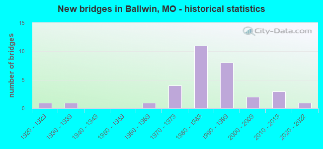
- New bridges - historical statistics
- 11920-1929
- 11930-1939
- 11960-1969
- 41970-1979
- 111980-1989
- 81990-1999
- 22000-2009
- 32010-2019
- 12020-2022

- Reconstructed bridges - Historical Statistics
- 11950-1959
- 01960-1969
- 01970-1979
- 01980-1989
- 01990-1999
- 12000-2009


- Bridge Condition - Deck
- 11.1%Excellent
- 11.1%Very good
- 33.3%Good
- 33.3%Satisfactory
- 11.1%Fair

- Bridge Condition - Superstructure
- 20.0%Excellent
- 20.0%Very good
- 40.0%Satisfactory
- 20.0%Fair

- Bridge Condition - Substructure
- 10.0%Excellent
- 10.0%Very good
- 40.0%Good
- 20.0%Satisfactory
- 20.0%Fair

- Bridge Condition - Channel
- 4.5%Excellent
- 13.6%Good
- 50.0%Satisfactory
- 27.3%Fair
- 4.5%Poor

- Bridge Condition - Culverts
- 20.0%Good
- 60.0%Satisfactory
- 20.0%Fair
Find on map >> Show street view
Structure Number: 12912, Location: S 34 T 45 N R 4 E (Lat: 38.596164, Lng: -90.561522), Route carried "on" structure: City street , Year Built: 1970, Status: Posted for load, Structure Length: 1.04m (3.41ft), Average Daily Traffic: 300 (year 2020), Truck Traffic: 1%, Average Future Daily Traffic: 405 (year 2040), Features Intersected: FISHPOT CR, Facility Carried by Structure: SMITH DR
Minimum Vertical Clearance: 30+ m (98+ ft), Kilometerpoint: 0.161, Lanes on structure: 2, Owner: City or Municipal Highway Agency, Approaching Roadway Width: 7.9m (25.9ft), Material/Design: Concrete continuous, Design/Construction: Culvert, Number Of Spans In Main Unit: 3, Length of Maximum Span: 3.0m (9.8ft), Curb-To-Curb Width: 7.9m (25.9ft), Out-to-Out Width: 10.4m (34.1ft)
Condition: Channel: Fair, Culverts: Fair, Operating Rating: 49.5 metric tons, Method Used To Determine Operating Rating: Field evaluation and documented engineering judgment, Inventory Rating: 16.2 metric tons, Method Used To Determine Inventory Rating: Field evaluation and documented engineering judgment, Structural Evaluation: Somewhat better than minimum adequacy, Deck Geometry: Somewhat better than minimum adequacy, Waterway Adequacy: Equal to present desirable criteria, Approach Roadway Alignment: Better than present minimum criteria, Designated Inspection Frequency: Every 24 months, Inspection Date: December 2021
Find on map >> Show street view
Structure Number: 12913, Location: S 34 T 45 N R 4 E (Lat: 38.591800, Lng: -90.552808), Route carried "on" structure: City street , Year Built: 1994, Status: Posted for load, Structure Length: 1.04m (3.41ft), Average Daily Traffic: 3,000 (year 2020), Truck Traffic: 1%, Average Future Daily Traffic: 4,050 (year 2040), Features Intersected: FISHPOT CR, Facility Carried by Structure: OLD BALLWIN RD
Minimum Vertical Clearance: 30+ m (98+ ft), Kilometerpoint: 0.322, Lanes on structure: 2, Owner: City or Municipal Highway Agency, Approaching Roadway Width: 7.6m (24.9ft), Material/Design: Concrete, Design/Construction: Culvert, Number Of Spans In Main Unit: 2, Length of Maximum Span: 4.6m (15.1ft), Curb-To-Curb Width: 7.6m (24.9ft), Out-to-Out Width: 12.3m (40.4ft)
Condition: Channel: Fair, Culverts: Good, Operating Rating: 54.0 metric tons, Method Used To Determine Operating Rating: Load Factor (LF), Inventory Rating: 32.4 metric tons, Method Used To Determine Inventory Rating: Load Factor (LF), Structural Evaluation: Better than present minimum criteria, Deck Geometry: High priority of replacement, Waterway Adequacy: Equal to present desirable criteria, Approach Roadway Alignment: Equal to present desirable criteria, Length Of Structure Improvement: 0.17m (0.56ft), Designated Inspection Frequency: Every 24 months, Inspection Date: December 2021, Bridge Improvement Cost: $85,000, Roadway Improvement Cost: $9,000, Total Project Cost: $128,000 ( Estimate for 2022)
Find on map >> Show street view
Structure Number: 12915, Location: S 25 T 45 N R 4 E (Lat: 38.603864, Lng: -90.529706), Route carried "on" structure: City street , Year Built: 1976, Status: Posted for load, Structure Length: 0.88m (2.89ft), Average Daily Traffic: 250 (year 2020), Truck Traffic: 1%, Average Future Daily Traffic: 338 (year 2040), Design Load: H 10, Features Intersected: GRAND GLAIZE CR, Facility Carried by Structure: FOREST LEAF DR
Minimum Vertical Clearance: 30+ m (98+ ft), Kilometerpoint: 0.644, Lanes on structure: 2, Owner: City or Municipal Highway Agency, Approaching Roadway Width: 7.3m (24.0ft), Material/Design: Concrete, Design/Construction: Culvert, Number Of Spans In Main Unit: 2, Length of Maximum Span: 4.3m (14.1ft)
Condition: Channel: Satisfactory, Culverts: Satisfactory, Operating Rating: 35.1 metric tons, Method Used To Determine Operating Rating: Allowable Stress (AS), Inventory Rating: 22.5 metric tons, Method Used To Determine Inventory Rating: Allowable Stress (AS), Structural Evaluation: Equal to present minimum criteria, Waterway Adequacy: Equal to present desirable criteria, Approach Roadway Alignment: Equal to present minimum criteria, Designated Inspection Frequency: Every 24 months, Inspection Date: December 2021
Find on map >> Show street view
Structure Number: 12916, Location: S 35 T 45 N R 4 E (Lat: 38.601261, Lng: -90.541050), Route carried "on" structure: City street , Year Built: 1976, Year Reconstructed: 2014, Status: Open, Structure Length: 2.07m (6.79ft), Average Daily Traffic: 13,260 (year 2020), Truck Traffic: 10%, Average Future Daily Traffic: 17,901 (year 2040), Features Intersected: GRAND GLAIZE CR, Facility Carried by Structure: HOLLOWAY RD
Minimum Vertical Clearance: 30+ m (98+ ft), Kilometerpoint: 0.805, Lanes on structure: 2, Owner: City or Municipal Highway Agency, Approaching Roadway Width: 8.5m (27.9ft), Material/Design: Concrete, Design/Construction: Culvert, Number Of Spans In Main Unit: 1, Length of Maximum Span: 4.3m (14.1ft)
Condition: Channel: Satisfactory, Culverts: Satisfactory, Operating Rating: 31.5 metric tons, Method Used To Determine Operating Rating: Allowable Stress (AS), Inventory Rating: 25.2 metric tons, Method Used To Determine Inventory Rating: Allowable Stress (AS), Structural Evaluation: Equal to present minimum criteria, Waterway Adequacy: Equal to present desirable criteria, Approach Roadway Alignment: Equal to present minimum criteria, Designated Inspection Frequency: Every 24 months, Inspection Date: December 2021
Find on map >> Show street view
Structure Number: 12917, Location: S 11 T 44 N R 4 E (Lat: 38.571000, Lng: -90.544086), Route carried "on" structure: City street , Year Built: 1991, Status: Open, Structure Length: 0.76m (2.49ft), Average Daily Traffic: 150 (year 2020), Truck Traffic: 1%, Average Future Daily Traffic: 203 (year 2040), Features Intersected: BR OF FISHPOT CR, Facility Carried by Structure: MARK WESLEY LN
Minimum Vertical Clearance: 30+ m (98+ ft), Kilometerpoint: 0.966, Lanes on structure: 2, Owner: City or Municipal Highway Agency, Approaching Roadway Width: 7.6m (24.9ft), Material/Design: Concrete, Design/Construction: Culvert, Number Of Spans In Main Unit: 3, Length of Maximum Span: 2.4m (7.9ft)
Condition: Channel: Fair, Culverts: Satisfactory, Operating Rating: 31.5 metric tons, Method Used To Determine Operating Rating: Allowable Stress (AS), Inventory Rating: 25.2 metric tons, Method Used To Determine Inventory Rating: Allowable Stress (AS), Structural Evaluation: Equal to present minimum criteria, Waterway Adequacy: Equal to present desirable criteria, Approach Roadway Alignment: Equal to present minimum criteria, Designated Inspection Frequency: Every 24 months, Inspection Date: December 2021
Find on map >> Show street view
Structure Number: 12918, Location: S 11 T 44 N R 4 E (Lat: 38.570964, Lng: -90.546547), Route carried "on" structure: City street , Year Built: 1991, Status: Open, Structure Length: 0.67m (2.20ft), Average Daily Traffic: 150 (year 2020), Truck Traffic: 1%, Average Future Daily Traffic: 203 (year 2040), Features Intersected: BR OF FISHPOT CR, Facility Carried by Structure: MARK WESLEY LN
Minimum Vertical Clearance: 30+ m (98+ ft), Kilometerpoint: 0.966, Lanes on structure: 2, Owner: City or Municipal Highway Agency, Approaching Roadway Width: 7.6m (24.9ft), Skew: 3 degrees, Material/Design: Concrete, Design/Construction: Culvert, Number Of Spans In Main Unit: 2, Length of Maximum Span: 2.4m (7.9ft)
Condition: Channel: Satisfactory, Culverts: Satisfactory, Operating Rating: 31.5 metric tons, Method Used To Determine Operating Rating: Allowable Stress (AS), Inventory Rating: 25.2 metric tons, Method Used To Determine Inventory Rating: Allowable Stress (AS), Structural Evaluation: Equal to present minimum criteria, Waterway Adequacy: Equal to present desirable criteria, Approach Roadway Alignment: Equal to present desirable criteria, Designated Inspection Frequency: Every 24 months, Inspection Date: December 2021
Find on map >> Show street view
Structure Number: 15611, Location: S 31 T 45 N R 5 E (Lat: 38.553106, Lng: -90.551758), Route carried "on" structure: County highway , Year Built: 1932, Status: Posted for load, Structure Length: 0.85m (2.79ft), Average Daily Traffic: 772 (year 2020), Truck Traffic: 5%, Average Future Daily Traffic: 1,042 (year 2040), Features Intersected: KIEFER CR, Facility Carried by Structure: NEW BALLWIN RD
Minimum Vertical Clearance: 30+ m (98+ ft), Kilometerpoint: 7.886, Lanes on structure: 2, Owner: County Highway Agency, Approaching Roadway Width: 6.1m (20.0ft), Material/Design: Concrete, Design/Construction: Slab, Number Of Spans In Main Unit: 1, Length of Maximum Span: 7.6m (24.9ft), Curb or Sidewalk Widths: Left: 1.4m (4.6ft), Right: 0.0m, Curb-To-Curb Width: 6.2m (20.3ft), Out-to-Out Width: 7.9m (25.9ft)
Condition: Deck: Fair, Superstructure: Fair, Substructure: Fair, Channel: Fair, Operating Rating: 45.0 metric tons, Method Used To Determine Operating Rating: Allowable Stress (AS), Inventory Rating: 20.7 metric tons, Method Used To Determine Inventory Rating: Allowable Stress (AS), Structural Evaluation: Somewhat better than minimum adequacy, Deck Geometry: High priority of corrective action, Waterway Adequacy: Better than present minimum criteria, Approach Roadway Alignment: Equal to present minimum criteria, Length Of Structure Improvement: 0.15m (0.49ft), Designated Inspection Frequency: Every 24 months, Inspection Date: Febuary 2021, Bridge Improvement Cost: $162,000, Roadway Improvement Cost: $16,000, Total Project Cost: $243,000 ( Estimate for 2022), Deck Structure Type: Concrete Cast-file-Place, Wearing Surface/Protective System: Wearing Surface: Bituminous
Find on map >> Show street view
Structure Number: 15612, Location: S 15 T 44 N R 4 E (Lat: 38.555639, Lng: -90.551361), Route carried "on" structure: County highway , Year Built: 1962, Status: Posted for load, Structure Length: 1.37m (4.49ft), Average Daily Traffic: 242 (year 2020), Truck Traffic: 3%, Average Future Daily Traffic: 327 (year 2040), Features Intersected: KIEFER CR, Facility Carried by Structure: CASTLEWOOD RD
Minimum Vertical Clearance: 30+ m (98+ ft), Kilometerpoint: 8.047, Lanes on structure: 2, Owner: County Highway Agency, Approaching Roadway Width: 7.3m (24.0ft), Skew: 1 degrees, Material/Design: Steel, Design/Construction: Stringer/Multi-beam, Number Of Spans In Main Unit: 1, Length of Maximum Span: 12.2m (40.0ft), Curb-To-Curb Width: 6.9m (22.6ft), Out-to-Out Width: 7.3m (24.0ft)
Condition: Deck: Good, Superstructure: Satisfactory, Substructure: Satisfactory, Channel: Satisfactory, Operating Rating: 89.1 metric tons, Method Used To Determine Operating Rating: Load Factor (LF), Inventory Rating: 59.4 metric tons, Method Used To Determine Inventory Rating: Load Factor (LF), Structural Evaluation: Equal to present minimum criteria, Deck Geometry: Meets minimum limits, Waterway Adequacy: Somewhat better than minimum adequacy, Approach Roadway Alignment: Equal to present desirable criteria, Designated Inspection Frequency: Every 24 months, Inspection Date: Febuary 2021, Deck Structure Type: Concrete Precast Panels, Wearing Surface/Protective System: Wearing Surface: Monolithic Concrete, Membrane: Epoxy
Find on map >> Show street view
Structure Number: 15695, Location: S 35 T 45 N R 4 E (Lat: 38.602464, Lng: -90.529681), Route carried "on" structure: County highway , Year Built: 1982, Status: Posted for load, Structure Length: 1.55m (5.09ft), Average Daily Traffic: 7,752 (year 2020), Truck Traffic: 3%, Average Future Daily Traffic: 10,465 (year 2040), Design Load: HS 20, Features Intersected: BR OF GLAIZE CR, Facility Carried by Structure: BAXTER RD
Minimum Vertical Clearance: 30+ m (98+ ft), Kilometerpoint: 0.000, Lanes on structure: 2, Owner: County Highway Agency, Approaching Roadway Width: 8.8m (28.9ft), Material/Design: Concrete continuous, Design/Construction: Culvert, Number Of Spans In Main Unit: 2, Length of Maximum Span: 4.6m (15.1ft)
Condition: Channel: Satisfactory, Culverts: Satisfactory, Operating Rating: 79.2 metric tons, Method Used To Determine Operating Rating: Allowable Stress (AS), Inventory Rating: 41.4 metric tons, Method Used To Determine Inventory Rating: Allowable Stress (AS), Structural Evaluation: Equal to present minimum criteria, Waterway Adequacy: Equal to present desirable criteria, Approach Roadway Alignment: Equal to present desirable criteria, Designated Inspection Frequency: Every 24 months, Inspection Date: March 2021
Find on map >> Show street view
Structure Number: 25284, Location: S 14 T 44 N R 4 E (Lat: 38.550797, Lng: -90.540628), Route carried "on" structure: County highway , Year Built: 1991, Status: Open, Structure Length: 0.70m (2.30ft), Average Daily Traffic: 350 (year 2020), Truck Traffic: 2%, Average Future Daily Traffic: 473 (year 2040), Features Intersected: KIEFER CR, Facility Carried by Structure: KIEFER CREEK RD
Minimum Vertical Clearance: 30+ m (98+ ft), Kilometerpoint: 0.161, Lanes on structure: 2, Owner: State Park, Forest, or Reservation Agency, Approaching Roadway Width: 6.1m (20.0ft), Material/Design: Concrete, Design/Construction: Culvert, Number Of Spans In Main Unit: 2, Length of Maximum Span: 3.4m (11.2ft)
Condition: Channel: Fair, Culverts: Fair, Operating Rating: 31.5 metric tons, Method Used To Determine Operating Rating: Allowable Stress (AS), Inventory Rating: 25.2 metric tons, Method Used To Determine Inventory Rating: Allowable Stress (AS), Structural Evaluation: Somewhat better than minimum adequacy, Waterway Adequacy: Equal to present minimum criteria, Approach Roadway Alignment: Equal to present minimum criteria, Designated Inspection Frequency: Every 24 months, Inspection Date: December 2021
Find on map >> Show street view
Structure Number: 28365, Location: S 10 T 44 N R 4 E (Lat: 38.560219, Lng: -90.556953), Route carried "on" structure: County highway , Year Built: 1999, Status: Posted for load, Structure Length: 1.86m (6.10ft), Average Daily Traffic: 6,520 (year 2020), Truck Traffic: 2%, Average Future Daily Traffic: 8,802 (year 2040), Design Load: HS 20+Mod, Features Intersected: BR OF KIEFER CR, Facility Carried by Structure: KIEFER CREEK RD
Minimum Vertical Clearance: 30+ m (98+ ft), Kilometerpoint: 0.000, Lanes on structure: 2, Owner: County Highway Agency, Approaching Roadway Width: 11.6m (38.1ft), Skew: 5 degrees, Material/Design: Concrete continuous, Design/Construction: Culvert, Number Of Spans In Main Unit: 3, Length of Maximum Span: 6.4m (21.0ft), Curb or Sidewalk Widths: Left: 0.2m (0.7ft), Right: 0.2m (0.7ft)
Condition: Channel: Satisfactory, Culverts: Good, Operating Rating: 90.0 metric tons, Method Used To Determine Operating Rating: Load Factor (LF), Inventory Rating: 54.0 metric tons, Method Used To Determine Inventory Rating: Load Factor (LF), Structural Evaluation: Better than present minimum criteria, Waterway Adequacy: Superior to present desirable criteria, Approach Roadway Alignment: Equal to present desirable criteria, Designated Inspection Frequency: Every 24 months, Inspection Date: Febuary 2021
Find on map >> Show street view
Structure Number: 28377, Location: S 9 T 44 N R 4 E (Lat: 38.573900, Lng: -90.576831), Route carried "on" structure: City street , Year Built: 1994, Status: Posted for load, Structure Length: 0.67m (2.20ft), Average Daily Traffic: 1,360 (year 2020), Truck Traffic: 2%, Average Future Daily Traffic: 1,836 (year 2040), Design Load: HS 20, Features Intersected: KIEFER CR, Facility Carried by Structure: BUCKHURST DR
Minimum Vertical Clearance: 30+ m (98+ ft), Kilometerpoint: 0.000, Lanes on structure: 2, Owner: City or Municipal Highway Agency, Approaching Roadway Width: 7.9m (25.9ft), Material/Design: Concrete, Design/Construction: Culvert, Number Of Spans In Main Unit: 2, Length of Maximum Span: 3.0m (9.8ft)
Condition: Channel: Good, Culverts: Satisfactory, Operating Rating: 89.1 metric tons, Method Used To Determine Operating Rating: Load Factor (LF), Inventory Rating: 58.5 metric tons, Method Used To Determine Inventory Rating: Load Factor (LF), Structural Evaluation: Equal to present minimum criteria, Waterway Adequacy: Equal to present desirable criteria, Approach Roadway Alignment: Equal to present desirable criteria, Designated Inspection Frequency: Every 24 months, Inspection Date: December 2021
Find on map >> Show street view
Structure Number: 28378, Location: S 9 T 44 N R 4 E (Lat: 38.571475, Lng: -90.575339), Route carried "on" structure: City street , Year Built: 1993, Status: Posted for load, Structure Length: 1.74m (5.71ft), Average Daily Traffic: 500 (year 2020), Truck Traffic: 2%, Average Future Daily Traffic: 675 (year 2040), Features Intersected: KIEFER CR, Facility Carried by Structure: RICHLAND MEADWS DR
Minimum Vertical Clearance: 30+ m (98+ ft), Kilometerpoint: 0.000, Lanes on structure: 2, Owner: City or Municipal Highway Agency, Approaching Roadway Width: 7.9m (25.9ft), Material/Design: Concrete continuous, Design/Construction: Culvert, Number Of Spans In Main Unit: 5, Length of Maximum Span: 3.0m (9.8ft)
Condition: Channel: Poor, Culverts: Satisfactory, Operating Rating: 47.7 metric tons, Method Used To Determine Operating Rating: Allowable Stress (AS), Inventory Rating: 27.9 metric tons, Method Used To Determine Inventory Rating: Allowable Stress (AS), Structural Evaluation: Equal to present minimum criteria, Waterway Adequacy: Superior to present desirable criteria, Approach Roadway Alignment: Equal to present minimum criteria, Designated Inspection Frequency: Every 24 months, Inspection Date: December 2021
Find on map >> Show street view
Structure Number: 28519, Location: S 33 T 44 N R 6 E (Lat: 38.504194, Lng: -90.347147), Route carried "on" structure: County highway , Year Built: 2000, Status: Posted for load, Structure Length: 0.67m (2.20ft), Average Daily Traffic: 240 (year 2020), Truck Traffic: 1%, Average Future Daily Traffic: 324 (year 2040), Design Load: HS 20, Features Intersected: BR OF MATTESE CR, Facility Carried by Structure: VON TALGE MEADOWS
Minimum Vertical Clearance: 30+ m (98+ ft), Kilometerpoint: 5.472, Lanes on structure: 2, Owner: County Highway Agency, Approaching Roadway Width: 7.6m (24.9ft), Material/Design: Concrete continuous, Design/Construction: Culvert, Number Of Spans In Main Unit: 2, Length of Maximum Span: 3.7m (12.1ft)
Condition: Channel: Satisfactory, Culverts: Satisfactory, Operating Rating: 72.0 metric tons, Method Used To Determine Operating Rating: Load Factor (LF), Inventory Rating: 43.2 metric tons, Method Used To Determine Inventory Rating: Load Factor (LF), Structural Evaluation: Equal to present minimum criteria, Waterway Adequacy: Better than present minimum criteria, Approach Roadway Alignment: Equal to present desirable criteria, Designated Inspection Frequency: Every 24 months, Inspection Date: March 2020
Find on map >> Show street view
Structure Number: 3044, Location: S 12 T 61 N R 14 W (Lat: 40.096339, Lng: -92.414600), Route carried "on" structure: State highway V, Year Built: 1977, Status: Open, Structure Length: 6.43m (21.10ft), Average Daily Traffic: 106 (year 2021), Truck Traffic: 9%, Average Future Daily Traffic: 133 (year 2041), Design Load: H 15, Features Intersected: BNSF RR
Minimum Vertical Clearance: 30+ m (98+ ft), Kilometerpoint: 6.864, Lanes on structure: 2, Owner: State Highway Agency, Approaching Roadway Width: 6.1m (20.0ft), Material/Design: Prestressed concrete continuous, Design/Construction: Stringer/Multi-beam, Number Of Spans In Main Unit: 3, Length of Maximum Span: 21.3m (69.9ft), Curb or Sidewalk Widths: Left: 0.2m (0.7ft), Right: 0.2m (0.7ft), Curb-To-Curb Width: 8.5m (27.9ft), Out-to-Out Width: 9.5m (31.2ft)
Condition: Deck: Good, Superstructure: Satisfactory, Substructure: Good, Operating Rating: 37.8 metric tons, Method Used To Determine Operating Rating: Load Factor (LF), Inventory Rating: 18.0 metric tons, Method Used To Determine Inventory Rating: Load Factor (LF), Structural Evaluation: Somewhat better than minimum adequacy, Deck Geometry: Equal to present minimum criteria, Underclear: Superior to present desirable criteria, Approach Roadway Alignment: Equal to present desirable criteria, Designated Inspection Frequency: Every 24 months, Inspection Date: December 2021, Deck Structure Type: Concrete Cast-file-Place, Wearing Surface/Protective System: Wearing Surface: Bituminous
Find on map >> Show street view
Structure Number: 3044, Location: S 34 T 45 N R 4 E (Lat: 38.597694, Lng: -90.563028), Route carried "on" structure: City street , Year Built: 1995, Status: Posted for load, Structure Length: 0.98m (3.22ft), Average Daily Traffic: 350 (year 2020), Truck Traffic: 2%, Average Future Daily Traffic: 473 (year 2040), Design Load: HS 20, Features Intersected: FISHPOT CR, Facility Carried by Structure: HILLSDALE RD
Minimum Vertical Clearance: 30+ m (98+ ft), Kilometerpoint: 0.000, Lanes on structure: 2, Owner: City or Municipal Highway Agency, Approaching Roadway Width: 7.3m (24.0ft), Material/Design: Concrete, Design/Construction: Culvert, Number Of Spans In Main Unit: 1, Length of Maximum Span: 9.1m (29.9ft), Curb-To-Curb Width: 8.5m (27.9ft), Out-to-Out Width: 13.7m (44.9ft)
Condition: Channel: Fair, Culverts: Fair, Operating Rating: 54.0 metric tons, Method Used To Determine Operating Rating: Load Factor (LF), Inventory Rating: 32.4 metric tons, Method Used To Determine Inventory Rating: Load Factor (LF), Structural Evaluation: Somewhat better than minimum adequacy, Deck Geometry: Equal to present minimum criteria, Waterway Adequacy: Equal to present desirable criteria, Approach Roadway Alignment: Somewhat better than minimum adequacy, Designated Inspection Frequency: Every 24 months, Inspection Date: December 2021
Find on map >> Show street view
Structure Number: 316, Location: S 11 T 44 N R 4 E (Lat: 38.567706, Lng: -90.541161), Route carried "on" structure: County highway , Year Built: 2008, Status: Posted for load, Structure Length: 1.21m (3.97ft), Average Daily Traffic: 27,120 (year 2020), Truck Traffic: 6%, Average Future Daily Traffic: 36,612 (year 2040), Design Load: HS 25 or greater, Features Intersected: TRIB TO FISHPOT CR, Facility Carried by Structure: BIG BEND RD
Minimum Vertical Clearance: 30+ m (98+ ft), Kilometerpoint: 0.000, Lanes on structure: 4, Owner: County Highway Agency, Approaching Roadway Width: 17.7m (58.1ft), Skew: 1 degrees, Material/Design: Concrete continuous, Design/Construction: Culvert, Number Of Spans In Main Unit: 3, Length of Maximum Span: 3.8m (12.5ft), Curb or Sidewalk Widths: Left: 1.5m (4.9ft), Right: 1.5m (4.9ft)
Condition: Channel: Satisfactory, Culverts: Good, Structural Evaluation: Better than present minimum criteria, Waterway Adequacy: Superior to present desirable criteria, Approach Roadway Alignment: Equal to present desirable criteria, Designated Inspection Frequency: Every 24 months, Inspection Date: March 2020
Find on map >> Show street view
Structure Number: 3342, Location: S 24 T 45 N R 4 E (Lat: 38.628100, Lng: -90.515139), Route carried "on" structure: Ramp State highway , Year Built: 1989, Status: Open, Structure Length: 8.32m (27.30ft), Average Daily Traffic: 10,817 (year 2021), Truck Traffic: 5%, Average Future Daily Traffic: 13,521 (year 2041), Design Load: HS 20+Mod, Features Intersected: OR 141, Facility Carried by Structure: RP MO141S TO CLAYT
Minimum Vertical Clearance: 30+ m (98+ ft), Kilometerpoint: 0.126, Lanes on structure: 1, Lanes under structure: 2, Base Highway Network: Yes, Owner: State Highway Agency, Approaching Roadway Width: 10.4m (34.1ft), Skew: 5 degrees, Material/Design: Prestressed concrete continuous, Design/Construction: Stringer/Multi-beam, Number Of Spans In Main Unit: 5, Length of Maximum Span: 21.9m (71.9ft), Curb or Sidewalk Widths: Left: 0.2m (0.7ft), Right: 0.2m (0.7ft), Curb-To-Curb Width: 10.0m (32.8ft), Out-to-Out Width: 10.8m (35.4ft)
Condition: Deck: Satisfactory, Superstructure: Satisfactory, Substructure: Good, Operating Rating: 67.5 metric tons, Method Used To Determine Operating Rating: Load Factor (LF), Inventory Rating: 38.7 metric tons, Method Used To Determine Inventory Rating: Load Factor (LF), Structural Evaluation: Equal to present minimum criteria, Deck Geometry: Superior to present desirable criteria, Underclear: Meets minimum limits, Approach Roadway Alignment: Equal to present desirable criteria, Designated Inspection Frequency: Every 24 months, Inspection Date: October 2020, Deck Structure Type: Concrete Cast-file-Place, Wearing Surface/Protective System: Wearing Surface: Epoxy Overlay, Deck Protection: Epoxy Coated Reinforcing
Find on map >> Show street view
Structure Number: 35141, Location: S 15 T 44 N R 4 E (Lat: 38.556619, Lng: -90.553631), Route carried "on" structure: County highway , Year Built: 2016, Status: Open, Structure Length: 1.46m (4.79ft), Average Daily Traffic: 1,164 (year 2020), Truck Traffic: 2%, Average Future Daily Traffic: 1,571 (year 2040), Features Intersected: KIEFER CR, Facility Carried by Structure: NEW BALLWIN RD
Minimum Vertical Clearance: 30+ m (98+ ft), Kilometerpoint: 8.208, Lanes on structure: 2, Owner: County Highway Agency, Approaching Roadway Width: 8.5m (27.9ft), Skew: 5 degrees, Material/Design: Prestressed concrete, Design/Construction: Box Beam or Girders - Multiple, Number Of Spans In Main Unit: 1, Length of Maximum Span: 13.7m (44.9ft), Curb or Sidewalk Widths: Left: 0.0m, Right: 1.5m (4.9ft), Curb-To-Curb Width: 8.5m (27.9ft), Out-to-Out Width: 11.3m (37.1ft)
Condition: Deck: Very good, Superstructure: Very good, Substructure: Good, Channel: Good, Operating Rating: 46.8 metric tons, Method Used To Determine Operating Rating: Load Factor (LF), Inventory Rating: 36.0 metric tons, Method Used To Determine Inventory Rating: Load Factor (LF), Structural Evaluation: Better than present minimum criteria, Deck Geometry: Somewhat better than minimum adequacy, Waterway Adequacy: Better than present minimum criteria, Approach Roadway Alignment: Equal to present minimum criteria, Designated Inspection Frequency: Every 24 months, Inspection Date: Febuary 2021, Deck Structure Type: Concrete Cast-file-Place, Wearing Surface/Protective System: Wearing Surface: Monolithic Concrete, Deck Protection: Epoxy Coated Reinforcing
Find on map >> Show street view
Structure Number: 3554, Location: S 13 T 45 N R 4 E (Lat: 38.642547, Lng: -90.510261), Route carried "on" structure: Ramp State highway , Year Built: 1985, Status: Open, Structure Length: 6.89m (22.60ft), Average Daily Traffic: 12,936 (year 2021), Truck Traffic: 18%, Average Future Daily Traffic: 16,170 (year 2041), Design Load: HS 20+Mod, Features Intersected: CO NORTH FORTY DR TO SOR, Facility Carried by Structure: RP IS64W TO MO141S
Minimum Vertical Clearance: 30+ m (98+ ft), Kilometerpoint: 0.681, Lanes on structure: 2, Lanes under structure: 10, Base Highway Network: Yes, Owner: State Highway Agency, Approaching Roadway Width: 11.0m (36.1ft), Material/Design: Steel continuous, Design/Construction: Stringer/Multi-beam, Number Of Spans In Main Unit: 3, Length of Maximum Span: 30.5m (100.1ft), Curb or Sidewalk Widths: Left: 0.2m (0.7ft), Right: 0.2m (0.7ft), Curb-To-Curb Width: 10.6m (34.8ft), Out-to-Out Width: 11.4m (37.4ft)
Condition: Deck: Satisfactory, Superstructure: Satisfactory, Substructure: Fair, Operating Rating: 60.3 metric tons, Method Used To Determine Operating Rating: Load Factor (LF), Inventory Rating: 36.0 metric tons, Method Used To Determine Inventory Rating: Load Factor (LF), Structural Evaluation: Somewhat better than minimum adequacy, Deck Geometry: Better than present minimum criteria, Underclear: Meets minimum limits, Approach Roadway Alignment: Equal to present desirable criteria, Designated Inspection Frequency: Every 24 months, Inspection Date: October 2020, Deck Structure Type: Concrete Cast-file-Place, Wearing Surface/Protective System: Wearing Surface: Monolithic Concrete, Deck Protection: Epoxy Coated Reinforcing
Find on map >> Show street view
Structure Number: 35676, Location: S 34 T 45 N R 4 E (Lat: 38.591472, Lng: -90.549444), Route carried "on" structure: City street , Year Built: 2018, Status: Open, Structure Length: 1.59m (5.22ft), Average Daily Traffic: 4,000 (year 2020), Truck Traffic: 1%, Average Future Daily Traffic: 5,400 (year 2040), Design Load: HS 20, Features Intersected: FISHPOT CR, Facility Carried by Structure: RAMSEY LN
Minimum Vertical Clearance: 30+ m (98+ ft), Kilometerpoint: 0.483, Lanes on structure: 2, Owner: City or Municipal Highway Agency, Approaching Roadway Width: 8.5m (27.9ft), Skew: 2 degrees, Material/Design: Prestressed concrete, Design/Construction: Box Beam or Girders - Single/Spread, Number Of Spans In Main Unit: 1, Length of Maximum Span: 14.6m (47.9ft), Curb or Sidewalk Widths: Left: 1.5m (4.9ft), Right: 1.5m (4.9ft), Curb-To-Curb Width: 8.8m (28.9ft), Out-to-Out Width: 13.1m (43.0ft)
Condition: Deck: Good, Superstructure: Excellent, Substructure: Very good, Channel: Good, Operating Rating: 63.0 metric tons, Method Used To Determine Operating Rating: Load Factor (LF), Inventory Rating: 48.6 metric tons, Method Used To Determine Inventory Rating: Load Factor (LF), Structural Evaluation: Equal to present desirable criteria, Deck Geometry: Meets minimum limits, Waterway Adequacy: Superior to present desirable criteria, Approach Roadway Alignment: Equal to present desirable criteria, Designated Inspection Frequency: Every 24 months, Inspection Date: December 2021, Deck Structure Type: Concrete Cast-file-Place, Wearing Surface/Protective System: Wearing Surface: Monolithic Concrete, Deck Protection: Epoxy Coated Reinforcing
Find on map >> Show street view
Structure Number: 35677, Location: S 2 T 44 N R 4 E (Lat: 38.585833, Lng: -90.540833), Route carried "on" structure: City street , Year Built: 2018, Status: Open, Structure Length: 1.82m (5.97ft), Average Daily Traffic: 8,914 (year 2020), Truck Traffic: 1%, Average Future Daily Traffic: 12,034 (year 2040), Design Load: HS 20, Features Intersected: FISHPOT CR, Facility Carried by Structure: RIES RD
Minimum Vertical Clearance: 30+ m (98+ ft), Kilometerpoint: 0.000, Lanes on structure: 2, Owner: City or Municipal Highway Agency, Approaching Roadway Width: 7.9m (25.9ft), Material/Design: Concrete, Design/Construction: Arch - Deck, Number Of Spans In Main Unit: 1, Length of Maximum Span: 16.8m (55.1ft), Curb or Sidewalk Widths: Left: 1.5m (4.9ft), Right: 1.5m (4.9ft), Curb-To-Curb Width: 7.9m (25.9ft), Out-to-Out Width: 12.3m (40.4ft)
Condition: Superstructure: Very good, Substructure: Good, Channel: Satisfactory, Operating Rating: 54.0 metric tons, Method Used To Determine Operating Rating: Load Factor (LF), Inventory Rating: 32.4 metric tons, Method Used To Determine Inventory Rating: Load Factor (LF), Structural Evaluation: Better than present minimum criteria, Deck Geometry: High priority of replacement, Waterway Adequacy: Superior to present desirable criteria, Approach Roadway Alignment: Equal to present desirable criteria, Designated Inspection Frequency: Every 24 months, Inspection Date: December 2021
Find on map >> Show street view
Structure Number: 36631, Location: S 15 T 44 N R 4 E (Lat: 38.553222, Lng: -90.551847), Route carried "on" structure: County highway 96, Year Built: 2021, Status: Not yet open, Structure Length: 1.83m (6.00ft), Average Daily Traffic: 772 (year 2021), Truck Traffic: 5%, Average Future Daily Traffic: 1,042 (year 2041), Design Load: HS 20, Features Intersected: SPRING BR, Facility Carried by Structure: NEW BALLWIN ROAD
Minimum Vertical Clearance: 30+ m (98+ ft), Kilometerpoint: 4.506, Lanes on structure: 2, Owner: County Highway Agency, Approaching Roadway Width: 8.9m (29.2ft), Skew: 2 degrees, Material/Design: Prestressed concrete, Design/Construction: Stringer/Multi-beam, Number Of Spans In Main Unit: 1, Length of Maximum Span: 17.2m (56.4ft), Curb-To-Curb Width: 9.0m (29.5ft), Out-to-Out Width: 9.8m (32.2ft)
Condition: Deck: Excellent, Superstructure: Excellent, Substructure: Excellent, Channel: Excellent, Operating Rating: 62.1 metric tons, Method Used To Determine Operating Rating: Load Factor (LF), Inventory Rating: 47.7 metric tons, Method Used To Determine Inventory Rating: Load Factor (LF), Structural Evaluation: Superior to present desirable criteria, Deck Geometry: Somewhat better than minimum adequacy, Waterway Adequacy: Better than present minimum criteria, Approach Roadway Alignment: Equal to present desirable criteria, Designated Inspection Frequency: Every 24 months, Inspection Date: August 2021, Deck Structure Type: Concrete Cast-file-Place, Wearing Surface/Protective System: Wearing Surface: Monolithic Concrete, Deck Protection: Epoxy Coated Reinforcing
Find on map >> Show street view
Structure Number: 3904, Location: S 13 T 45 N R 4 E (Lat: 38.646033, Lng: -90.527114), Route carried "on" structure: Interstate 64, Year Built: 1988, Status: Open, Structure Length: 5.55m (18.21ft), Average Daily Traffic: 63,579 (year 2021), Truck Traffic: 11%, Average Future Daily Traffic: 79,474 (year 2041), Design Load: HS 20+Mod, Features Intersected: CREVE COEUR CR
Minimum Vertical Clearance: 30+ m (98+ ft), Kilometerpoint: 34.747, Lanes on structure: 3, Base Highway Network: Yes, Owner: State Highway Agency, Approaching Roadway Width: 15.8m (51.8ft), Skew: 4 degrees, Material/Design: Prestressed concrete continuous, Design/Construction: Tee Beam, Number Of Spans In Main Unit: 5, Length of Maximum Span: 11.3m (37.1ft), Curb or Sidewalk Widths: Left: 0.2m (0.7ft), Right: 0.2m (0.7ft), Curb-To-Curb Width: 15.2m (49.9ft), Out-to-Out Width: 16.0m (52.5ft)
Condition: Deck: Satisfactory, Superstructure: Fair, Substructure: Satisfactory, Channel: Satisfactory, Operating Rating: 76.5 metric tons, Method Used To Determine Operating Rating: Load Factor (LF), Inventory Rating: 45.9 metric tons, Method Used To Determine Inventory Rating: Load Factor (LF), Structural Evaluation: Somewhat better than minimum adequacy, Deck Geometry: Meets minimum limits, Waterway Adequacy: Superior to present desirable criteria, Approach Roadway Alignment: Equal to present desirable criteria, Designated Inspection Frequency: Every 24 months, Inspection Date: October 2020, Deck Structure Type: Concrete Cast-file-Place, Wearing Surface/Protective System: Wearing Surface: Epoxy Overlay, Deck Protection: Epoxy Coated Reinforcing
Find on map >> Show street view
Structure Number: 4455, Location: S 34 T 45 N R 4 E (Lat: 38.592861, Lng: -90.556203), Route carried "on" structure: State highway 100, Year Built: 1921, Year Reconstructed: 1962, Status: Open, Structure Length: 1.39m (4.56ft), Average Daily Traffic: 40,321 (year 2021), Truck Traffic: 8%, Average Future Daily Traffic: 56,449 (year 2041), Design Load: H 20, Features Intersected: FISHPOT CR
Minimum Vertical Clearance: 30+ m (98+ ft), Kilometerpoint: 161.973, Lanes on structure: 5, Base Highway Network: Yes, Owner: State Highway Agency, Approaching Roadway Width: 21.3m (69.9ft), Skew: 3 degrees, Material/Design: Concrete continuous, Design/Construction: Culvert, Number Of Spans In Main Unit: 2, Length of Maximum Span: 4.3m (14.1ft)
Condition: Channel: Satisfactory, Culverts: Satisfactory, Operating Rating: 62.1 metric tons, Method Used To Determine Operating Rating: Load Factor (LF), Inventory Rating: 36.9 metric tons, Method Used To Determine Inventory Rating: Load Factor (LF), Structural Evaluation: Equal to present minimum criteria, Waterway Adequacy: Equal to present minimum criteria, Approach Roadway Alignment: Equal to present desirable criteria, Designated Inspection Frequency: Every 24 months, Inspection Date: November 2021
Find on map >> Show street view
Structure Number: 3342, Location: S 24 T 45 N R 4 E (Lat: 38.628100, Lng: -90.515139), Route carried "under" structure: ServiceState highway 141, Year Built: 1989, Structure Length: 0. m, Average Daily Traffic: 4,434 (year 2021), Truck Traffic: 4%, Features Intersected: OR 141
Minimum Vertical Clearance: 5.12m (16.80ft), Kilometerpoint: 1.452, Lanes on structure: 1, Lanes under structure: 2, Material/Design: Prestressed concrete continuous, Design/Construction: Stringer/Multi-beam, Length of Maximum Span: 21.9m (71.9ft)
Find on map >> Show street view
Structure Number: 3554, Location: S 13 T 45 N R 4 E (Lat: 38.642547, Lng: -90.510261), Route carried "under" structure: State highway 141, Year Built: 1985, Structure Length: 0. m, Average Daily Traffic: 23,514 (year 2021), Truck Traffic: 5%, Features Intersected: MO 141
Minimum Vertical Clearance: 5.08m (16.67ft), Kilometerpoint: 19.605, Lanes on structure: 2, Lanes under structure: 3, Material/Design: Steel continuous, Design/Construction: Stringer/Multi-beam, Length of Maximum Span: 30.5m (100.1ft)
Find on map >> Show street view
Structure Number: 3554, Location: S 13 T 45 N R 4 E (Lat: 38.642547, Lng: -90.510261), Route carried "under" structure: Ramp State highway , Year Built: 1985, Structure Length: 0. m, Average Daily Traffic: 549 (year 2021), Truck Traffic: 5%, Features Intersected: CO NORTH FORTY DR TO SOR, Facility Carried by Structure: RP IS64W TO MO141S
Minimum Vertical Clearance: 5.21m (17.09ft), Kilometerpoint: 0.153, Lanes on structure: 2, Lanes under structure: 1, Material/Design: Steel continuous, Design/Construction: Stringer/Multi-beam, Length of Maximum Span: 30.5m (100.1ft)
Find on map >> Show street view
Structure Number: 3554, Location: S 13 T 45 N R 4 E (Lat: 38.642547, Lng: -90.510261), Route carried "under" structure: State highway 141, Year Built: 1985, Structure Length: 0. m, Average Daily Traffic: 23,325 (year 2021), Truck Traffic: 5%, Features Intersected: MO 141
Minimum Vertical Clearance: 5.08m (16.67ft), Kilometerpoint: 30.069, Lanes on structure: 2, Lanes under structure: 5, Material/Design: Steel continuous, Design/Construction: Stringer/Multi-beam, Length of Maximum Span: 30.5m (100.1ft)
Find on map >> Show street view
Structure Number: 3557, Location: S 13 T 45 N R 4 E (Lat: 38.642228, Lng: -90.510383), Route carried "under" structure: Ramp State highway , Year Built: 1985, Structure Length: 0. m, Average Daily Traffic: 549 (year 2021), Truck Traffic: 5%, Features Intersected: CO NORTH FORTY DR TO SOR, Facility Carried by Structure: IS 64 E
Minimum Vertical Clearance: 5.13m (16.83ft), Kilometerpoint: 0.192, Lanes on structure: 3, Lanes under structure: 2, Material/Design: Steel continuous, Design/Construction: Stringer/Multi-beam, Length of Maximum Span: 30.5m (100.1ft)
Find on map >> Show street view
Structure Number: 3557, Location: S 13 T 45 N R 4 E (Lat: 38.642228, Lng: -90.510383), Route carried "under" structure: State highway 141, Year Built: 1985, Structure Length: 0. m, Average Daily Traffic: 32,486 (year 2021), Truck Traffic: 6%, Features Intersected: MO 141, Facility Carried by Structure: IS 64 E
Minimum Vertical Clearance: 5.03m (16.50ft), Kilometerpoint: 19.645, Lanes on structure: 3, Lanes under structure: 3, Material/Design: Steel continuous, Design/Construction: Stringer/Multi-beam, Length of Maximum Span: 30.5m (100.1ft)
Find on map >> Show street view
Structure Number: 3557, Location: S 13 T 45 N R 4 E (Lat: 38.642228, Lng: -90.510383), Route carried "under" structure: State highway 141, Year Built: 1985, Structure Length: 0. m, Average Daily Traffic: 27,843 (year 2021), Truck Traffic: 5%, Features Intersected: MO 141, Facility Carried by Structure: IS 64 E
Minimum Vertical Clearance: 5.06m (16.60ft), Kilometerpoint: 30.030, Lanes on structure: 3, Lanes under structure: 2, Material/Design: Steel continuous, Design/Construction: Stringer/Multi-beam, Length of Maximum Span: 30.5m (100.1ft)