Bridge Statistics for Badger, Alaska (AK)
Condition, Traffic, Stress, Structural Evaluation, Project Costs
- National Bridge Inventory (NBI) Statistics
- 10Number of bridges
- 190ft / 57.8mTotal length
- 22,990Total average daily traffic
- 1,725Total average daily truck traffic
- 28,505Total future (year 2035) average daily traffic
- National Bridge Inventory (NBI) Registered Bridges for Badger
- No street view available for this location
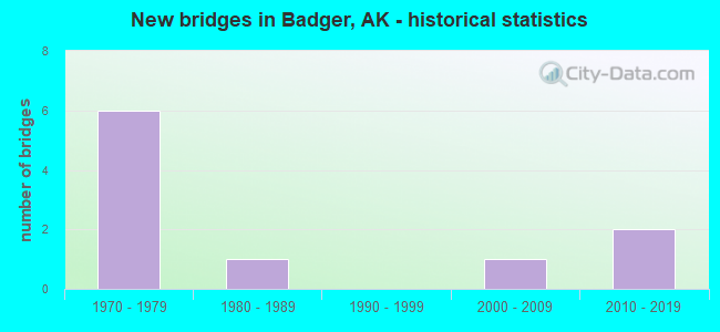
- New bridges - historical statistics
- 61970-1979
- 11980-1989
- 12000-2009
- 22010-2019


- Bridge Condition - Deck
- 20.0%Very good
- 60.0%Good
- 20.0%Satisfactory

- Bridge Condition - Superstructure
- 10.0%Excellent
- 10.0%Very good
- 60.0%Good
- 20.0%Fair

- Bridge Condition - Substructure
- 10.0%Very good
- 30.0%Good
- 40.0%Satisfactory
- 20.0%Fair

- Bridge Condition - Channel
- 12.5%Excellent
- 25.0%Good
- 25.0%Satisfactory
- 37.5%Fair
Find on map >> Show street view
Structure Number: 531, Location: MILE POINT 345.9 (Lat: 64.719936, Lng: -147.224772), Route carried "on" structure: Interstate A24, Year Built: 1971, Status: Open, Structure Length: 2.68m (8.79ft), Average Daily Traffic: 2,500 (year 2020), Truck Traffic: 7%, Average Future Daily Traffic: 2,995 (year 2039), Design Load: HS 20, Features Intersected: MOOSE CREEK EAST BOUND, Facility Carried by Structure: RICHARDSON HIGHWAY
Minimum Vertical Clearance: 5.46m (17.91ft), Kilometerpoint: 556.654, Lanes on structure: 2, Base Highway Network: Yes, Owner: State Highway Agency, Approaching Roadway Width: 13.7m (44.9ft), Material/Design: Steel, Design/Construction: Stringer/Multi-beam, Number Of Spans In Main Unit: 1, Length of Maximum Span: 25.9m (85.0ft), Curb-To-Curb Width: 12.2m (40.0ft), Out-to-Out Width: 13.1m (43.0ft)
Condition: Deck: Satisfactory, Superstructure: Good, Substructure: Good, Channel: Fair, Operating Rating: 65.5 metric tons, Method Used To Determine Operating Rating: Load Factor (LF), Inventory Rating: 30.2 metric tons, Method Used To Determine Inventory Rating: Load Factor (LF), Structural Evaluation: Better than present minimum criteria, Deck Geometry: Better than present minimum criteria, Waterway Adequacy: Equal to present minimum criteria, Approach Roadway Alignment: Equal to present desirable criteria, Designated Inspection Frequency: Every 24 months, Inspection Date: July 2020, Deck Structure Type: Concrete Cast-file-Place, Wearing Surface/Protective System: Wearing Surface: Monolithic Concrete
Find on map >> Show street view
Structure Number: 1017, Location: MILE POINT 0.1 (Lat: 59.436944, Lng: -151.708889), Route carried "on" structure: State highway 434, Year Built: 1979, Status: Open, Structure Length: 5.52m (18.11ft), Average Daily Traffic: 340 (year 2020), Truck Traffic: 6%, Average Future Daily Traffic: 390 (year 2039), Design Load: HS 20, Features Intersected: SELDOVIA SLOUGH, Facility Carried by Structure: IRR:AIRPORT ROAD
Minimum Vertical Clearance: 30+ m (98+ ft), Kilometerpoint: 0.163, Lanes on structure: 2, Owner: State Highway Agency, Approaching Roadway Width: 8.2m (26.9ft), Navigation Control: Yes ( Vertical Clearance: 3.9m (12.8ft), Horizontal Clearance: 17.0m (55.8ft)), Material/Design: Wood or Timber, Design/Construction: Stringer/Multi-beam, Number Of Spans In Main Unit: 3, Length of Maximum Span: 18.3m (60.0ft), Curb or Sidewalk Widths: Left: 0.0m, Right: 1.5m (4.9ft), Curb-To-Curb Width: 8.6m (28.2ft), Out-to-Out Width: 10.4m (34.1ft)
Condition: Deck: Good, Superstructure: Fair, Substructure: Fair, Channel: Good, Operating Rating: 52.9 metric tons, Method Used To Determine Operating Rating: Load Factor (LF), Inventory Rating: 28.0 metric tons, Method Used To Determine Inventory Rating: Load Factor (LF), Structural Evaluation: Somewhat better than minimum adequacy, Deck Geometry: Equal to present minimum criteria, Waterway Adequacy: Superior to present desirable criteria, Approach Roadway Alignment: Equal to present minimum criteria, Designated Inspection Frequency: Every 24 months, Inspection Date: August 2021, Deck Structure Type: Wood or Timber, Wearing Surface/Protective System: Wearing Surface: Wood or Timber
Find on map >> Show street view
Structure Number: 1018, Location: MILE POINT 0.6 (Lat: 59.779444, Lng: -151.817500), Route carried "on" structure: Spur State highway NSP00, Year Built: 1985, Status: Open, Structure Length: 1.31m (4.30ft), Average Daily Traffic: 1,150 (year 2020), Truck Traffic: 8%, Average Future Daily Traffic: 1,370 (year 2039), Design Load: HS 20, Features Intersected: NORTH FORK ANCHOR RIVER, Facility Carried by Structure: NORTH FORK ROAD
Minimum Vertical Clearance: 30+ m (98+ ft), Kilometerpoint: 0.882, Lanes on structure: 2, Owner: State Highway Agency, Approaching Roadway Width: 9.1m (29.9ft), Material/Design: Steel, Design/Construction: Box Beam or Girders - Multiple, Number Of Spans In Main Unit: 1, Length of Maximum Span: 11.0m (36.1ft), Curb-To-Curb Width: 9.1m (29.9ft), Out-to-Out Width: 10.1m (33.1ft)
Condition: Deck: Good, Superstructure: Fair, Substructure: Fair, Channel: Fair, Inventory Rating: 43.6 metric tons, Method Used To Determine Inventory Rating: Load Factor (LF), Structural Evaluation: Somewhat better than minimum adequacy, Deck Geometry: Somewhat better than minimum adequacy, Waterway Adequacy: Somewhat better than minimum adequacy, Approach Roadway Alignment: Equal to present desirable criteria, Designated Inspection Frequency: Every 24 months, Critical Feature Inspection Frequency: Every 24 months, Inspection Date: August 2021, Critical Feature Inspection Date: July 2020, Deck Structure Type: Concrete Cast-file-Place, Wearing Surface/Protective System: Wearing Surface: Bituminous, Membrane: Preformed Fabric
Find on map >> Show street view
Structure Number: 1212, Location: MILE POINT 2.3 (Lat: 64.846586, Lng: -147.410386), Route carried "on" structure: State highway 653, Year Built: 1975, Year Reconstructed: 2013, Status: Open, Structure Length: 5.49m (18.01ft), Average Daily Traffic: 2,110 (year 2020), Truck Traffic: 7%, Average Future Daily Traffic: 2,830 (year 2039), Design Load: HS 20, Features Intersected: CHENA RIVER (NORDALE RD), Facility Carried by Structure: NORDALE ROAD
Minimum Vertical Clearance: 30+ m (98+ ft), Kilometerpoint: 3.761, Lanes on structure: 2, Owner: State Highway Agency, Approaching Roadway Width: 11.0m (36.1ft), Navigation Control: Yes ( Vertical Clearance: 2.4m (7.9ft), Horizontal Clearance: 20.1m (65.9ft)), Material/Design: Prestressed concrete, Design/Construction: Tee Beam, Number Of Spans In Main Unit: 2, Length of Maximum Span: 26.6m (87.3ft), Curb-To-Curb Width: 10.4m (34.1ft), Out-to-Out Width: 11.3m (37.1ft)
Condition: Deck: Good, Superstructure: Good, Substructure: Satisfactory, Channel: Good, Operating Rating: 81.0 metric tons, Method Used To Determine Operating Rating: Load Factor (LF), Inventory Rating: 37.2 metric tons, Method Used To Determine Inventory Rating: Load Factor (LF), Structural Evaluation: Equal to present minimum criteria, Deck Geometry: Somewhat better than minimum adequacy, Waterway Adequacy: Better than present minimum criteria, Approach Roadway Alignment: Equal to present minimum criteria, Designated Inspection Frequency: Every 24 months, Underwater Inspection Frequency: Every 60 months, Inspection Date: August 2020, Underwater Inspection Date: August 2019, Deck Structure Type: Other, Wearing Surface/Protective System: Wearing Surface: Bituminous, Membrane: Preformed Fabric
Find on map >> Show street view
Structure Number: 1329, Location: MILE POINT 3.0 (Lat: 64.856258, Lng: -147.405364), Route carried "on" structure: State highway 653, Year Built: 1975, Status: Open, Structure Length: 4.02m (13.19ft), Average Daily Traffic: 2,320 (year 2020), Truck Traffic: 12%, Average Future Daily Traffic: 2,830 (year 2039), Design Load: HS 20, Features Intersected: LITTLE CHENA RIVER, Facility Carried by Structure: NORDALE ROAD
Minimum Vertical Clearance: 30+ m (98+ ft), Kilometerpoint: 4.892, Lanes on structure: 2, Owner: State Highway Agency, Approaching Roadway Width: 11.0m (36.1ft), Skew: 2 degrees, Material/Design: Prestressed concrete, Design/Construction: Tee Beam, Number Of Spans In Main Unit: 2, Length of Maximum Span: 19.2m (63.0ft), Curb-To-Curb Width: 10.4m (34.1ft), Out-to-Out Width: 11.3m (37.1ft)
Condition: Deck: Good, Superstructure: Good, Substructure: Satisfactory, Channel: Satisfactory, Operating Rating: 77.5 metric tons, Method Used To Determine Operating Rating: Load Factor (LF), Inventory Rating: 33.1 metric tons, Method Used To Determine Inventory Rating: Load Factor (LF), Structural Evaluation: Equal to present minimum criteria, Deck Geometry: Somewhat better than minimum adequacy, Waterway Adequacy: Equal to present desirable criteria, Approach Roadway Alignment: Better than present minimum criteria, Designated Inspection Frequency: Every 24 months, Inspection Date: August 2020, Deck Structure Type: Other, Wearing Surface/Protective System: Wearing Surface: Bituminous, Membrane: Preformed Fabric
Find on map >> Show street view
Structure Number: 1364, Location: MILE POINT 346.8 (Lat: 64.725664, Lng: -147.254869), Route carried "on" structure: Interstate A24, Year Built: 1977, Status: Open, Structure Length: 29.93m (98.20ft), Average Daily Traffic: 3,990 (year 2020), Truck Traffic: 7%, Average Future Daily Traffic: 4,985 (year 2039), Design Load: HS 20, Features Intersected: CHENA FLOOD CHANL - N.B., Facility Carried by Structure: RICHARDSON HIGHWAY
Minimum Vertical Clearance: 5.46m (17.91ft), Kilometerpoint: 558.072, Lanes on structure: 2, Base Highway Network: Yes, Owner: State Highway Agency, Approaching Roadway Width: 12.2m (40.0ft), Material/Design: Prestressed concrete, Design/Construction: Tee Beam, Number Of Spans In Main Unit: 14, Length of Maximum Span: 21.3m (69.9ft), Curb-To-Curb Width: 10.1m (33.1ft), Out-to-Out Width: 11.0m (36.1ft)
Condition: Deck: Satisfactory, Superstructure: Good, Substructure: Good, Channel: Excellent, Operating Rating: 52.2 metric tons, Method Used To Determine Operating Rating: Load Factor (LF), Inventory Rating: 22.4 metric tons, Method Used To Determine Inventory Rating: Load Factor (LF), Structural Evaluation: Somewhat better than minimum adequacy, Deck Geometry: Meets minimum limits, Waterway Adequacy: Equal to present desirable criteria, Approach Roadway Alignment: Equal to present desirable criteria, Designated Inspection Frequency: Every 24 months, Inspection Date: July 2020, Deck Structure Type: Other, Wearing Surface/Protective System: Wearing Surface: Bituminous, Membrane: Preformed Fabric
Find on map >> Show street view
Structure Number: 1832, Location: MILE POINT 345.9 (Lat: 64.720178, Lng: -147.224594), Route carried "on" structure: Interstate A24, Year Built: 1971, Status: Open, Structure Length: 2.65m (8.69ft), Average Daily Traffic: 2,500 (year 2020), Truck Traffic: 7%, Average Future Daily Traffic: 2,995 (year 2039), Design Load: HS 20, Features Intersected: MOOSE CREEK WEST BOUND, Facility Carried by Structure: RICHARDSON HIGHWAY
Minimum Vertical Clearance: 5.46m (17.91ft), Kilometerpoint: 556.654, Lanes on structure: 2, Base Highway Network: Yes, Owner: State Highway Agency, Approaching Roadway Width: 13.7m (44.9ft), Material/Design: Steel, Design/Construction: Stringer/Multi-beam, Number Of Spans In Main Unit: 1, Length of Maximum Span: 26.2m (86.0ft), Curb-To-Curb Width: 12.2m (40.0ft), Out-to-Out Width: 13.1m (43.0ft)
Condition: Deck: Good, Superstructure: Good, Substructure: Satisfactory, Channel: Fair, Operating Rating: 65.5 metric tons, Method Used To Determine Operating Rating: Load Factor (LF), Inventory Rating: 30.2 metric tons, Method Used To Determine Inventory Rating: Load Factor (LF), Structural Evaluation: Equal to present minimum criteria, Deck Geometry: Better than present minimum criteria, Waterway Adequacy: Equal to present minimum criteria, Approach Roadway Alignment: Equal to present desirable criteria, Designated Inspection Frequency: Every 24 months, Inspection Date: July 2020, Deck Structure Type: Concrete Cast-file-Place, Wearing Surface/Protective System: Wearing Surface: Monolithic Concrete
Find on map >> Show street view
Structure Number: 2123, Location: MILE POINT 346.9 (Lat: 64.722764, Lng: -147.245164), Route carried "on" structure: Interstate , Year Built: 2014, Status: Open, Structure Length: 2.45m (8.04ft), Average Daily Traffic: 3,990 (year 2020), Truck Traffic: 7%, Average Future Daily Traffic: 4,985 (year 2039), Design Load: HL 93, Features Intersected: MOOSE CREEK OVERHEAD SB, Facility Carried by Structure: RICHARDSON HIGHWAY
Minimum Vertical Clearance: 5.46m (17.91ft), Kilometerpoint: 558.289, Lanes on structure: 2, Base Highway Network: Yes, Owner: State Highway Agency, Approaching Roadway Width: 11.0m (36.1ft), Skew: 3 degrees, Material/Design: Prestressed concrete, Design/Construction: Tee Beam, Number Of Spans In Main Unit: 1, Length of Maximum Span: 23.9m (78.4ft), Curb-To-Curb Width: 11.6m (38.1ft), Out-to-Out Width: 12.5m (41.0ft)
Condition: Deck: Very good, Superstructure: Excellent, Substructure: Good, Operating Rating: 87.7 metric tons, Method Used To Determine Operating Rating: Load Factor (LF), Inventory Rating: 40.4 metric tons, Method Used To Determine Inventory Rating: Load Factor (LF), Structural Evaluation: Better than present minimum criteria, Deck Geometry: Equal to present minimum criteria, Underclear: Superior to present desirable criteria, Approach Roadway Alignment: Equal to present desirable criteria, Designated Inspection Frequency: Every 24 months, Inspection Date: July 2020, Deck Structure Type: Other, Wearing Surface/Protective System: Wearing Surface: Bituminous, Membrane: Preformed Fabric, Deck Protection: Epoxy Coated Reinforcing
Find on map >> Show street view
Structure Number: 2124, Location: MILE POINT 346.9 (Lat: 64.722906, Lng: -147.244606), Route carried "on" structure: Interstate , Year Built: 2015, Status: Open, Structure Length: 2.47m (8.10ft), Average Daily Traffic: 3,990 (year 2020), Truck Traffic: 7%, Average Future Daily Traffic: 4,985 (year 2039), Design Load: HL 93, Features Intersected: MOOSE CREEK OVERHEAD NB, Facility Carried by Structure: RICHARDSON HIGHWAY
Minimum Vertical Clearance: 5.46m (17.91ft), Kilometerpoint: 558.289, Lanes on structure: 2, Base Highway Network: Yes, Owner: State Highway Agency, Approaching Roadway Width: 11.0m (36.1ft), Skew: 3 degrees, Material/Design: Prestressed concrete, Design/Construction: Tee Beam, Number Of Spans In Main Unit: 1, Length of Maximum Span: 24.1m (79.1ft), Curb-To-Curb Width: 11.6m (38.1ft), Out-to-Out Width: 12.5m (41.0ft)
Condition: Deck: Good, Superstructure: Very good, Substructure: Very good, Operating Rating: 87.7 metric tons, Method Used To Determine Operating Rating: Load Factor (LF), Inventory Rating: 40.4 metric tons, Method Used To Determine Inventory Rating: Load Factor (LF), Structural Evaluation: Equal to present desirable criteria, Deck Geometry: Equal to present minimum criteria, Underclear: Superior to present desirable criteria, Approach Roadway Alignment: Equal to present desirable criteria, Designated Inspection Frequency: Every 24 months, Inspection Date: July 2020, Deck Structure Type: Other, Wearing Surface/Protective System: Wearing Surface: Bituminous, Membrane: Preformed Fabric, Deck Protection: Epoxy Coated Reinforcing
Find on map >> Show street view
Structure Number: 2139, Location: MILE POINT 0.1 (Lat: 64.769569, Lng: -147.343158), Route carried "on" structure: City street , Year Built: 2003, Status: Open, Structure Length: 1.24m (4.07ft), Average Daily Traffic: 100 (year 2018), Truck Traffic: 1%, Average Future Daily Traffic: 140 (year 2035), Design Load: HS 20, Features Intersected: CHENA SLOUGH, Facility Carried by Structure: AIRWAY DRIVE
Minimum Vertical Clearance: 30+ m (98+ ft), Kilometerpoint: 0.150, Lanes on structure: 2, Owner: County Highway Agency, Approaching Roadway Width: 7.3m (24.0ft), Material/Design: Steel, Design/Construction: Stringer/Multi-beam, Number Of Spans In Main Unit: 1, Length of Maximum Span: 11.7m (38.4ft), Curb-To-Curb Width: 6.1m (20.0ft), Out-to-Out Width: 6.2m (20.3ft)
Condition: Deck: Very good, Superstructure: Good, Substructure: Satisfactory, Channel: Satisfactory, Operating Rating: 53.8 metric tons, Method Used To Determine Operating Rating: Load Factor (LF), Inventory Rating: 32.6 metric tons, Method Used To Determine Inventory Rating: Load Factor (LF), Structural Evaluation: Equal to present minimum criteria, Deck Geometry: Somewhat better than minimum adequacy, Waterway Adequacy: Equal to present minimum criteria, Approach Roadway Alignment: Equal to present desirable criteria, Designated Inspection Frequency: Every 24 months, Inspection Date: August 2020, Deck Structure Type: Wood or Timber, Wearing Surface/Protective System: Wearing Surface: Wood or Timber