Bridge Statistics for Aurora, Ohio (OH)
Condition, Traffic, Stress, Structural Evaluation, Project Costs
- National Bridge Inventory (NBI) Statistics
- 18Number of bridges
- 131ft / 39.5mTotal length
- $205,000,000Total costs
- 96,815Total average daily traffic
- 8,438Total average daily truck traffic
- National Bridge Inventory (NBI) Registered Bridges for Aurora
- No street view available for this location
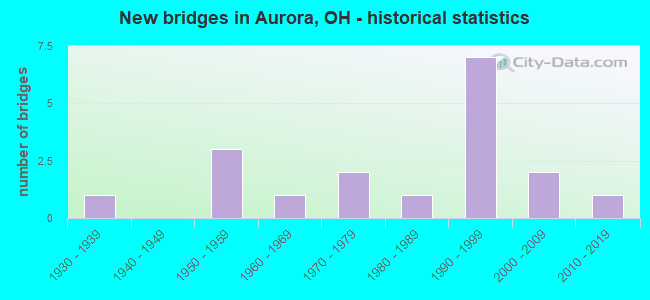
- New bridges - historical statistics
- 11930-1939
- 31950-1959
- 11960-1969
- 21970-1979
- 11980-1989
- 71990-1999
- 22000-2009
- 12010-2019
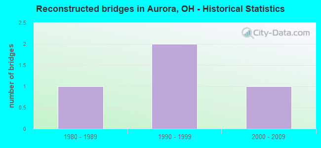
- Reconstructed bridges - Historical Statistics
- 11980-1989
- 21990-1999
- 12000-2009
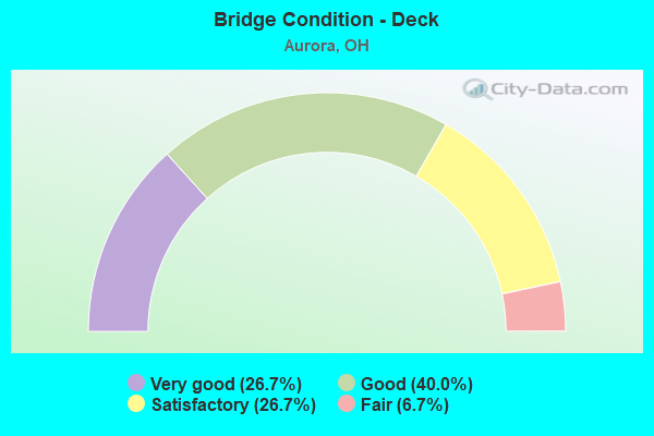
- Bridge Condition - Deck
- 26.7%Very good
- 40.0%Good
- 26.7%Satisfactory
- 6.7%Fair
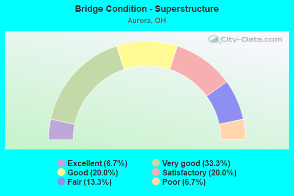
- Bridge Condition - Superstructure
- 6.7%Excellent
- 33.3%Very good
- 20.0%Good
- 20.0%Satisfactory
- 13.3%Fair
- 6.7%Poor
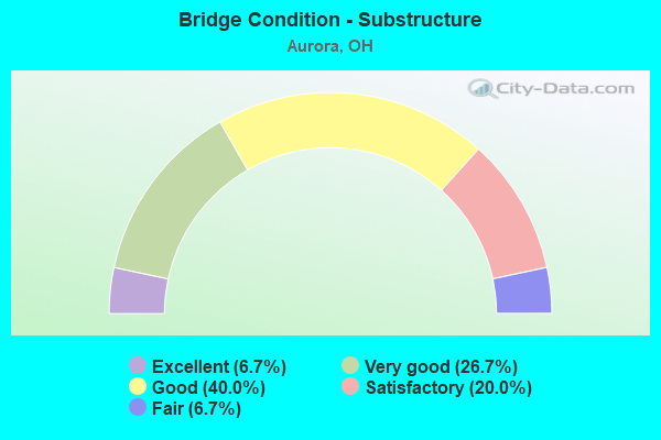
- Bridge Condition - Substructure
- 6.7%Excellent
- 26.7%Very good
- 40.0%Good
- 20.0%Satisfactory
- 6.7%Fair
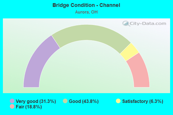
- Bridge Condition - Channel
- 31.3%Very good
- 43.8%Good
- 6.3%Satisfactory
- 18.8%Fair
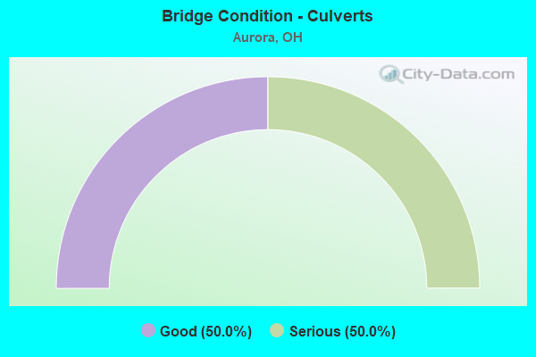
- Bridge Condition - Culverts
- 50.0%Good
- 50.0%Serious
Find on map >> Show street view
Structure Number: 2803445, Location: 3.01 MI W SR 44 (Lat: 41.381011, Lng: -81.274681), Route carried "on" structure: County highway C0032, Year Built: 1990, Status: Open, Structure Length: 6.98m (22.90ft), Average Daily Traffic: 20,040 (year 2001), Truck Traffic: 15%, Average Future Daily Traffic: 24,572 (year 2021), Design Load: HS 20+Mod, Features Intersected: USR 422 ALT (0616), Facility Carried by Structure: MUNN RD
Minimum Vertical Clearance: 30+ m (98+ ft), Kilometerpoint: 3.782, Lanes on structure: 2, Lanes under structure: 4, Owner: State Highway Agency, Approaching Roadway Width: 10.4m (34.1ft), Material/Design: Steel continuous, Design/Construction: Stringer/Multi-beam, Number Of Spans In Main Unit: 2, Length of Maximum Span: 34.4m (112.9ft), Curb-To-Curb Width: 9.1m (29.9ft), Out-to-Out Width: 10.1m (33.1ft)
Condition: Deck: Good, Superstructure: Good, Substructure: Good, Operating Rating: 42.1 metric tons, Method Used To Determine Operating Rating: Load Factor (LF) rating reported by rating factor (RF) method using MS18 loading, Inventory Rating: 32.4 metric tons, Method Used To Determine Inventory Rating: Load Factor (LF) rating reported by rating factor (RF) method using MS18 loading, Structural Evaluation: Better than present minimum criteria, Deck Geometry: Meets minimum limits, Underclear: Better than present minimum criteria, Approach Roadway Alignment: Equal to present desirable criteria, Designated Inspection Frequency: Every 24 months, Inspection Date: April 2021, Deck Structure Type: Other, Wearing Surface/Protective System: Wearing Surface: Latex Concrete, Deck Protection: Epoxy Coated Reinforcing
Find on map >> Show street view
Structure Number: 2803461, Location: 2.54 MI W OF SR 44 (Lat: 41.381769, Lng: -81.265561), Route carried "on" structure: US 422, Year Built: 1990, Status: Open, Structure Length: 3.75m (12.30ft), Average Daily Traffic: 8,852 (year 2018), Truck Traffic: 10%, Average Future Daily Traffic: 12,287 (year 2038), Design Load: HS 20+Mod, Features Intersected: BRIDGE CRK 2.53 MI. W 44
Minimum Vertical Clearance: 30+ m (98+ ft), Kilometerpoint: 10.654, Lanes on structure: 2, Base Highway Network: Yes, Owner: State Highway Agency, Approaching Roadway Width: 12.2m (40.0ft), Material/Design: Prestressed concrete, Design/Construction: Box Beam or Girders - Multiple, Number Of Spans In Main Unit: 3, Length of Maximum Span: 12.2m (40.0ft), Curb-To-Curb Width: 12.2m (40.0ft), Out-to-Out Width: 13.2m (43.3ft)
Condition: Deck: Good, Superstructure: Good, Substructure: Good, Channel: Good, Operating Rating: 42.1 metric tons, Method Used To Determine Operating Rating: Load Factor (LF) rating reported by rating factor (RF) method using MS18 loading, Inventory Rating: 32.4 metric tons, Method Used To Determine Inventory Rating: Load Factor (LF) rating reported by rating factor (RF) method using MS18 loading, Structural Evaluation: Better than present minimum criteria, Deck Geometry: Better than present minimum criteria, Waterway Adequacy: Equal to present desirable criteria, Approach Roadway Alignment: Equal to present desirable criteria, Designated Inspection Frequency: Every 24 months, Inspection Date: May 2021, Deck Structure Type: Other, Wearing Surface/Protective System: Wearing Surface: Monolithic Concrete, Membrane: Epoxy
Find on map >> Show street view
Structure Number: 2803496, Location: 3.54 MI W OF SR 44 (Lat: 41.381550, Lng: -81.265511), Route carried "on" structure: US 422, Year Built: 1990, Status: Open, Structure Length: 3.75m (12.30ft), Average Daily Traffic: 8,852 (year 2018), Truck Traffic: 10%, Average Future Daily Traffic: 12,287 (year 2038), Design Load: HS 20+Mod, Features Intersected: BRIDGE CRK 2.53 MI. W 44
Minimum Vertical Clearance: 30+ m (98+ ft), Kilometerpoint: 10.654, Lanes on structure: 2, Base Highway Network: Yes, Owner: State Highway Agency, Approaching Roadway Width: 12.2m (40.0ft), Material/Design: Prestressed concrete, Design/Construction: Box Beam or Girders - Multiple, Number Of Spans In Main Unit: 3, Length of Maximum Span: 12.2m (40.0ft), Curb-To-Curb Width: 12.2m (40.0ft), Out-to-Out Width: 13.2m (43.3ft)
Condition: Deck: Good, Superstructure: Good, Substructure: Good, Channel: Good, Operating Rating: 42.1 metric tons, Method Used To Determine Operating Rating: Load Factor (LF) rating reported by rating factor (RF) method using MS18 loading, Inventory Rating: 32.4 metric tons, Method Used To Determine Inventory Rating: Load Factor (LF) rating reported by rating factor (RF) method using MS18 loading, Structural Evaluation: Better than present minimum criteria, Deck Geometry: Better than present minimum criteria, Waterway Adequacy: Equal to present desirable criteria, Approach Roadway Alignment: Equal to present desirable criteria, Designated Inspection Frequency: Every 24 months, Inspection Date: May 2021, Deck Structure Type: Concrete Cast-file-Place, Wearing Surface/Protective System: Wearing Surface: Monolithic Concrete, Membrane: Epoxy
Find on map >> Show street view
Structure Number: 2830248, Location: .5MI S OF TAYLOR-MAY RD (Lat: 41.369719, Lng: -81.246111), Route carried "on" structure: County highway C0004, Year Built: 1960, Status: Open, Structure Length: 3.29m (10.79ft), Average Daily Traffic: 1,255 (year 2015), Truck Traffic: 2%, Average Future Daily Traffic: 1,742 (year 2035), Design Load: H 20, Features Intersected: LADUE RESERVOIR, Facility Carried by Structure: AUBURN RD
Minimum Vertical Clearance: 30+ m (98+ ft), Kilometerpoint: 2.462, Lanes on structure: 2, Owner: County Highway Agency, Approaching Roadway Width: 8.5m (27.9ft), Material/Design: Concrete continuous, Design/Construction: Slab, Number Of Spans In Main Unit: 3, Length of Maximum Span: 12.2m (40.0ft), Curb-To-Curb Width: 7.3m (24.0ft), Out-to-Out Width: 7.3m (24.0ft)
Condition: Deck: Satisfactory, Superstructure: Fair, Substructure: Good, Channel: Very good, Operating Rating: 51.8 metric tons, Method Used To Determine Operating Rating: Load Factor (LF) rating reported by rating factor (RF) method using MS18 loading, Inventory Rating: 32.4 metric tons, Method Used To Determine Inventory Rating: Load Factor (LF) rating reported by rating factor (RF) method using MS18 loading, Structural Evaluation: Somewhat better than minimum adequacy, Deck Geometry: Meets minimum limits, Waterway Adequacy: Superior to present desirable criteria, Approach Roadway Alignment: Equal to present desirable criteria, Designated Inspection Frequency: Every 12 months, Inspection Date: November 2021, Deck Structure Type: Concrete Cast-file-Place, Wearing Surface/Protective System: Wearing Surface: Bituminous
Find on map >> Show street view
Structure Number: 2830493, Location: 1/4 MI E OF GEAUGA LAKE (Lat: 41.361969, Lng: -81.367869), Route carried "on" structure: County highway C0607, Year Built: 1930, Status: Open, Structure Length: 1.71m (5.61ft), Average Daily Traffic: 4,504 (year 2019), Truck Traffic: 4%, Average Future Daily Traffic: 7,622 (year 2039), Design Load: H 15, Features Intersected: AURORA BR CHAGRIN RIVER, Facility Carried by Structure: PETTIBONE RD
Minimum Vertical Clearance: 30+ m (98+ ft), Kilometerpoint: 2.012, Lanes on structure: 2, Owner: County Highway Agency, Approaching Roadway Width: 7.3m (24.0ft), Material/Design: Concrete, Design/Construction: Tee Beam, Number Of Spans In Main Unit: 1, Length of Maximum Span: 15.9m (52.2ft), Curb-To-Curb Width: 6.9m (22.6ft), Out-to-Out Width: 6.9m (22.6ft)
Condition: Deck: Good, Superstructure: Fair, Substructure: Fair, Channel: Fair, Operating Rating: 42.1 metric tons, Method Used To Determine Operating Rating: Load Factor (LF) rating reported by rating factor (RF) method using MS18 loading, Inventory Rating: 25.9 metric tons, Method Used To Determine Inventory Rating: Load Factor (LF) rating reported by rating factor (RF) method using MS18 loading, Structural Evaluation: Somewhat better than minimum adequacy, Deck Geometry: High priority of replacement, Waterway Adequacy: Better than present minimum criteria, Approach Roadway Alignment: Equal to present desirable criteria, Designated Inspection Frequency: Every 12 months, Inspection Date: November 2021, Deck Structure Type: Concrete Cast-file-Place, Wearing Surface/Protective System: Wearing Surface: Bituminous
Find on map >> Show street view
Structure Number: 283059, Location: 500' N OF S SPRING VALLEY (Lat: 41.355669, Lng: -81.325719), Route carried "on" structure: County highway T0380, Year Built: 1957, Year Reconstructed: 1989, Status: Open, Structure Length: 0.82m (2.69ft), Average Daily Traffic: 1,949 (year 2015), Truck Traffic: 5%, Average Future Daily Traffic: 2,705 (year 2035), Design Load: HS 20, Features Intersected: SPRING CREEK, Facility Carried by Structure: RIVERVIEW DR
Minimum Vertical Clearance: 30+ m (98+ ft), Kilometerpoint: 0.499, Lanes on structure: 2, Owner: County Highway Agency, Approaching Roadway Width: 7.9m (25.9ft), Skew: 1 degrees, Material/Design: Steel, Design/Construction: Stringer/Multi-beam, Number Of Spans In Main Unit: 1, Length of Maximum Span: 7.3m (24.0ft), Curb-To-Curb Width: 7.6m (24.9ft), Out-to-Out Width: 7.9m (25.9ft)
Condition: Deck: Satisfactory, Superstructure: Poor, Substructure: Satisfactory, Channel: Good, Operating Rating: 61.6 metric tons, Method Used To Determine Operating Rating: Load Factor (LF) rating reported by rating factor (RF) method using MS18 loading, Inventory Rating: 38.9 metric tons, Method Used To Determine Inventory Rating: Load Factor (LF) rating reported by rating factor (RF) method using MS18 loading, Structural Evaluation: Meets minimum limits, Deck Geometry: Meets minimum limits, Waterway Adequacy: Superior to present desirable criteria, Approach Roadway Alignment: Equal to present desirable criteria, Designated Inspection Frequency: Every 12 months, Inspection Date: December 2021, Deck Structure Type: Corrugated Steel, Wearing Surface/Protective System: Wearing Surface: Bituminous
Find on map >> Show street view
Structure Number: 2832446, Location: .5 M. N. PORTAGE CTY LINE (Lat: 41.354561, Lng: -81.322950), Route carried "on" structure: County highway T0191, Year Built: 2018, Status: Open, Structure Length: 0.73m (2.40ft), Average Daily Traffic: 1,468 (year 2017), Truck Traffic: 2%, Average Future Daily Traffic: 2,038 (year 2037), Design Load: HL 93, Features Intersected: SPRING CREEK, Facility Carried by Structure: HASKINS RD
Minimum Vertical Clearance: 30+ m (98+ ft), Kilometerpoint: 0.772, Lanes on structure: 2, Owner: County Highway Agency, Approaching Roadway Width: 8.5m (27.9ft), Material/Design: Concrete, Design/Construction: Frame, Number Of Spans In Main Unit: 1, Length of Maximum Span: 6.7m (22.0ft), Curb-To-Curb Width: 8.5m (27.9ft), Out-to-Out Width: 18.3m (60.0ft)
Condition: Deck: Very good, Superstructure: Excellent, Substructure: Excellent, Channel: Very good, Operating Rating: 58.3 metric tons, Method Used To Determine Operating Rating: Load and Resistance Factor Rating (LRFR) rating reported by rating factor(RF) method using HL-93 loadings, Inventory Rating: 45.4 metric tons, Method Used To Determine Inventory Rating: Load and Resistance Factor Rating (LRFR) rating reported by rating factor(RF) method using HL-93 loadings, Structural Evaluation: Superior to present desirable criteria, Deck Geometry: Somewhat better than minimum adequacy, Waterway Adequacy: Better than present minimum criteria, Approach Roadway Alignment: Equal to present desirable criteria, Length Of Structure Improvement: 1.52m (4.99ft), Designated Inspection Frequency: Every 24 months, Inspection Date: December 2021, Total Project Cost: $205,000,000 ( Estimate for 2018), Deck Structure Type: Other, Wearing Surface/Protective System: Wearing Surface: Bituminous, Membrane: Preformed Fabric, Deck Protection: Other
Find on map >> Show street view
Structure Number: 2832569, Location: AT INT. OF THORPE (Lat: 41.377400, Lng: -81.263881), Route carried "on" structure: County highway T0186, Year Built: 1997, Status: Open, Structure Length: 2.35m (7.71ft), Average Daily Traffic: 618 (year 2017), Truck Traffic: 2%, Average Future Daily Traffic: 858 (year 2037), Design Load: HS 20+Mod, Features Intersected: BRIDGE CREEK, Facility Carried by Structure: TAYLOR MAY RD
Minimum Vertical Clearance: 30+ m (98+ ft), Kilometerpoint: 6.550, Lanes on structure: 2, Owner: County Highway Agency, Approaching Roadway Width: 5.8m (19.0ft), Material/Design: Prestressed concrete, Design/Construction: Box Beam or Girders - Multiple, Number Of Spans In Main Unit: 1, Length of Maximum Span: 23.0m (75.5ft), Curb-To-Curb Width: 9.1m (29.9ft), Out-to-Out Width: 9.3m (30.5ft)
Condition: Deck: Very good, Superstructure: Very good, Substructure: Very good, Channel: Very good, Operating Rating: 64.8 metric tons, Method Used To Determine Operating Rating: Load Factor (LF) rating reported by rating factor (RF) method using MS18 loading, Inventory Rating: 38.9 metric tons, Method Used To Determine Inventory Rating: Load Factor (LF) rating reported by rating factor (RF) method using MS18 loading, Structural Evaluation: Equal to present desirable criteria, Deck Geometry: Equal to present minimum criteria, Waterway Adequacy: Superior to present desirable criteria, Approach Roadway Alignment: Equal to present desirable criteria, Designated Inspection Frequency: Every 24 months, Inspection Date: December 2021, Deck Structure Type: Concrete Cast-file-Place, Wearing Surface/Protective System: Wearing Surface: Monolithic Concrete, Membrane: Other, Deck Protection: Epoxy Coated Reinforcing
Find on map >> Show street view
Structure Number: 2832739, Location: 1700' S. OF BARTHOLOMEW (Lat: 41.361600, Lng: -81.289781), Route carried "on" structure: County highway T0196, Year Built: 2003, Status: Open, Structure Length: 0.68m (2.23ft), Average Daily Traffic: 406 (year 2017), Truck Traffic: 2%, Average Future Daily Traffic: 564 (year 2037), Design Load: HS 20+Mod, Features Intersected: AURORA BR CHAGRIN RIVER, Facility Carried by Structure: QUINN RD
Minimum Vertical Clearance: 30+ m (98+ ft), Kilometerpoint: 0.161, Lanes on structure: 2, Owner: County Highway Agency, Approaching Roadway Width: 7.9m (25.9ft), Material/Design: Concrete, Design/Construction: Frame, Number Of Spans In Main Unit: 1, Length of Maximum Span: 6.2m (20.3ft), Curb-To-Curb Width: 7.9m (25.9ft), Out-to-Out Width: 14.6m (47.9ft)
Condition: Deck: Good, Superstructure: Very good, Substructure: Very good, Channel: Good, Operating Rating: 64.8 metric tons, Method Used To Determine Operating Rating: Load Factor (LF) rating reported by rating factor (RF) method using MS18 loading, Inventory Rating: 38.9 metric tons, Method Used To Determine Inventory Rating: Load Factor (LF) rating reported by rating factor (RF) method using MS18 loading, Structural Evaluation: Equal to present desirable criteria, Deck Geometry: Somewhat better than minimum adequacy, Waterway Adequacy: Better than present minimum criteria, Approach Roadway Alignment: Equal to present desirable criteria, Designated Inspection Frequency: Every 24 months, Inspection Date: October 2021, Deck Structure Type: Concrete Cast-file-Place, Wearing Surface/Protective System: Wearing Surface: Bituminous, Membrane: Preformed Fabric, Deck Protection: Other
Find on map >> Show street view
Structure Number: 2832933, Location: 0.31 Mi. EAST OF SR 306 (Lat: 41.355281, Lng: -81.333781), Route carried "on" structure: County highway T0378, Year Built: 2003, Status: Open, Structure Length: 0.80m (2.62ft), Average Daily Traffic: 1,949 (year 2015), Truck Traffic: 5%, Average Future Daily Traffic: 2,705 (year 2035), Design Load: HS 20+Mod, Features Intersected: AURORA BR CHAGRIN RIVER, Facility Carried by Structure: S SPRING VALLEY
Minimum Vertical Clearance: 30+ m (98+ ft), Kilometerpoint: 0.499, Lanes on structure: 2, Owner: County Highway Agency, Approaching Roadway Width: 7.3m (24.0ft), Material/Design: Concrete, Design/Construction: Culvert, Number Of Spans In Main Unit: 1, Length of Maximum Span: 7.4m (24.3ft)
Condition: Channel: Very good, Culverts: Good, Operating Rating: 71.3 metric tons, Method Used To Determine Operating Rating: Load Factor (LF) rating reported by rating factor (RF) method using MS18 loading, Inventory Rating: 42.1 metric tons, Method Used To Determine Inventory Rating: Load Factor (LF) rating reported by rating factor (RF) method using MS18 loading, Structural Evaluation: Better than present minimum criteria, Waterway Adequacy: Superior to present desirable criteria, Approach Roadway Alignment: Equal to present desirable criteria, Designated Inspection Frequency: Every 24 months, Inspection Date: December 2021, Wearing Surface/Protective System: Membrane: Preformed Fabric
Find on map >> Show street view
Structure Number: 2833018, Location: .8 MI. S. OF PETTIBONE RD (Lat: 41.357200, Lng: -81.360011), Route carried "on" structure: County highway T0184, Year Built: 1996, Status: Open, Structure Length: 2.35m (7.71ft), Average Daily Traffic: 429 (year 2017), Truck Traffic: 2%, Average Future Daily Traffic: 595 (year 2037), Design Load: HS 20+Mod, Features Intersected: AURORA BR CHAGRIN RIVER, Facility Carried by Structure: BREWSTER RD
Minimum Vertical Clearance: 30+ m (98+ ft), Kilometerpoint: 1.368, Lanes on structure: 2, Owner: County Highway Agency, Approaching Roadway Width: 5.5m (18.0ft), Skew: 2 degrees, Material/Design: Wood or Timber, Design/Construction: Stringer/Multi-beam, Number Of Spans In Main Unit: 1, Length of Maximum Span: 22.9m (75.1ft), Curb-To-Curb Width: 8.5m (27.9ft), Out-to-Out Width: 8.9m (29.2ft)
Condition: Deck: Good, Superstructure: Very good, Substructure: Very good, Channel: Fair, Operating Rating: 51.8 metric tons, Method Used To Determine Operating Rating: Allowable Stress (AS) rating reported by rating factor (RF) method using MS18 loading, Inventory Rating: 32.4 metric tons, Method Used To Determine Inventory Rating: Allowable Stress (AS) rating reported by rating factor (RF) method using MS18 loading, Structural Evaluation: Equal to present desirable criteria, Deck Geometry: Somewhat better than minimum adequacy, Waterway Adequacy: Superior to present desirable criteria, Approach Roadway Alignment: Equal to present desirable criteria, Designated Inspection Frequency: Every 24 months, Inspection Date: December 2021, Deck Structure Type: Wood or Timber, Wearing Surface/Protective System: Wearing Surface: Bituminous, Membrane: Other, Deck Protection: Other
Find on map >> Show street view
Structure Number: 6703259, Location: 1.65 MI W OF SR 43 (Lat: 41.309989, Lng: -81.378431), Route carried "on" structure: State highway 82, Year Built: 1992, Status: Open, Structure Length: 1.43m (4.69ft), Average Daily Traffic: 8,879 (year 2015), Truck Traffic: 5%, Average Future Daily Traffic: 12,324 (year 2035), Design Load: HS 20+Mod, Features Intersected: BR AURORA POND
Minimum Vertical Clearance: 30+ m (98+ ft), Kilometerpoint: 1.191, Lanes on structure: 2, Owner: State Highway Agency, Approaching Roadway Width: 13.4m (44.0ft), Material/Design: Prestressed concrete, Design/Construction: Box Beam or Girders - Multiple, Number Of Spans In Main Unit: 1, Length of Maximum Span: 14.0m (45.9ft), Curb-To-Curb Width: 12.2m (40.0ft), Out-to-Out Width: 12.2m (40.0ft)
Condition: Deck: Very good, Superstructure: Very good, Substructure: Very good, Channel: Very good, Operating Rating: 42.1 metric tons, Method Used To Determine Operating Rating: Load Factor (LF) rating reported by rating factor (RF) method using MS18 loading, Inventory Rating: 32.4 metric tons, Method Used To Determine Inventory Rating: Load Factor (LF) rating reported by rating factor (RF) method using MS18 loading, Structural Evaluation: Equal to present desirable criteria, Deck Geometry: Somewhat better than minimum adequacy, Waterway Adequacy: Equal to present desirable criteria, Approach Roadway Alignment: Better than present minimum criteria, Designated Inspection Frequency: Every 24 months, Inspection Date: April 2021, Deck Structure Type: Concrete Cast-file-Place, Wearing Surface/Protective System: Wearing Surface: Integral Concrete
Find on map >> Show street view
Structure Number: 6703283, Location: 0.81 MI E OF SR 306 (Lat: 41.317361, Lng: -81.329389), Route carried "on" structure: State highway 82, Year Built: 1977, Year Reconstructed: 2007, Status: Open, Structure Length: 1.37m (4.49ft), Average Daily Traffic: 8,149 (year 2015), Truck Traffic: 5%, Average Future Daily Traffic: 11,311 (year 2035), Design Load: HS 20+Mod, Features Intersected: AURORA BRANCH
Minimum Vertical Clearance: 30+ m (98+ ft), Kilometerpoint: 5.568, Lanes on structure: 2, Owner: State Highway Agency, Approaching Roadway Width: 12.2m (40.0ft), Skew: 2 degrees, Material/Design: Prestressed concrete, Design/Construction: Box Beam or Girders - Multiple, Number Of Spans In Main Unit: 1, Length of Maximum Span: 13.1m (43.0ft), Curb-To-Curb Width: 12.2m (40.0ft), Out-to-Out Width: 12.2m (40.0ft)
Condition: Deck: Very good, Superstructure: Very good, Substructure: Good, Channel: Good, Operating Rating: 42.1 metric tons, Method Used To Determine Operating Rating: Load Factor (LF) rating reported by rating factor (RF) method using MS18 loading, Inventory Rating: 32.4 metric tons, Method Used To Determine Inventory Rating: Load Factor (LF) rating reported by rating factor (RF) method using MS18 loading, Structural Evaluation: Better than present minimum criteria, Deck Geometry: Somewhat better than minimum adequacy, Waterway Adequacy: Equal to present desirable criteria, Approach Roadway Alignment: Better than present minimum criteria, Designated Inspection Frequency: Every 24 months, Inspection Date: April 2021, Deck Structure Type: Concrete Cast-file-Place, Wearing Surface/Protective System: Wearing Surface: Monolithic Concrete
Find on map >> Show street view
Structure Number: 6704743, Location: 1.89 MI E OF SR 82 .3M S (Lat: 41.343969, Lng: -81.342661), Route carried "on" structure: State highway 306, Year Built: 1952, Year Reconstructed: 1996, Status: Open, Structure Length: 4.15m (13.62ft), Average Daily Traffic: 8,155 (year 2015), Truck Traffic: 5%, Average Future Daily Traffic: 11,319 (year 2035), Design Load: HS 15, Features Intersected: BR CHAGRIN RIVER
Minimum Vertical Clearance: 30+ m (98+ ft), Kilometerpoint: 3.492, Lanes on structure: 2, Base Highway Network: Yes, Owner: State Highway Agency, Approaching Roadway Width: 6.1m (20.0ft), Skew: 1 degrees, Material/Design: Concrete continuous, Design/Construction: Slab, Number Of Spans In Main Unit: 3, Length of Maximum Span: 10.7m (35.1ft), Curb-To-Curb Width: 11.0m (36.1ft), Out-to-Out Width: 11.2m (36.7ft)
Condition: Deck: Satisfactory, Superstructure: Satisfactory, Substructure: Satisfactory, Channel: Good, Operating Rating: 32.4 metric tons, Method Used To Determine Operating Rating: Allowable Stress (AS) rating reported by rating factor (RF) method using MS18 loading, Inventory Rating: 29.2 metric tons, Method Used To Determine Inventory Rating: Allowable Stress (AS) rating reported by rating factor (RF) method using MS18 loading, Structural Evaluation: Equal to present minimum criteria, Deck Geometry: Meets minimum limits, Waterway Adequacy: Better than present minimum criteria, Approach Roadway Alignment: Better than present minimum criteria, Designated Inspection Frequency: Every 12 months, Inspection Date: April 2021, Deck Structure Type: Concrete Cast-file-Place, Wearing Surface/Protective System: Wearing Surface: Bituminous
Find on map >> Show street view
Structure Number: 6730329, Location: AURORA BR CHAGRIN RIVER (Lat: 41.304169, Lng: -81.310831), Route carried "on" structure: County highway T0254, Year Built: 1988, Status: Open, Structure Length: 0.73m (2.40ft), Average Daily Traffic: 636 (year 2015), Truck Traffic: 5%, Average Future Daily Traffic: 883 (year 2035), Design Load: HS 20, Features Intersected: AURORA BR CHAGRIN RIVER, Facility Carried by Structure: PIONEER TRAIL
Minimum Vertical Clearance: 30+ m (98+ ft), Kilometerpoint: 0.719, Lanes on structure: 2, Owner: County Highway Agency, Approaching Roadway Width: 5.8m (19.0ft), Material/Design: Steel, Design/Construction: Culvert, Number Of Spans In Main Unit: 2, Length of Maximum Span: 3.7m (12.1ft)
Condition: Channel: Fair, Culverts: Serious, Operating Rating: 48.6 metric tons, Method Used To Determine Operating Rating: Load Factor (LF) rating reported by rating factor (RF) method using MS18 loading, Inventory Rating: 38.9 metric tons, Method Used To Determine Inventory Rating: Load Factor (LF) rating reported by rating factor (RF) method using MS18 loading, Structural Evaluation: High priority of corrective action, Waterway Adequacy: Equal to present minimum criteria, Approach Roadway Alignment: Equal to present desirable criteria, Designated Inspection Frequency: Every 12 months, Inspection Date: October 2021
Find on map >> Show street view
Structure Number: 6733328, Location: 0.15 MI E OF JCT SR 306 (Lat: 41.347611, Lng: -81.336931), Route carried "on" structure: County highway T0269, Year Built: 1955, Year Reconstructed: 1997, Status: Open, Structure Length: 2.32m (7.61ft), Average Daily Traffic: 951 (year 2015), Truck Traffic: 5%, Average Future Daily Traffic: 1,320 (year 2035), Features Intersected: AURORA BR CHAGRIN RIVER, Facility Carried by Structure: TH176 CRACKEL RD.
Minimum Vertical Clearance: 30+ m (98+ ft), Kilometerpoint: 0.227, Lanes on structure: 2, Owner: County Highway Agency, Approaching Roadway Width: 6.4m (21.0ft), Material/Design: Steel, Design/Construction: Truss - Thru, Number Of Spans In Main Unit: 1, Length of Maximum Span: 21.9m (71.9ft), Curb-To-Curb Width: 6.0m (19.7ft), Out-to-Out Width: 6.9m (22.6ft)
Condition: Deck: Fair, Superstructure: Satisfactory, Substructure: Satisfactory, Channel: Satisfactory, Operating Rating: 48.6 metric tons, Method Used To Determine Operating Rating: Load Factor (LF) rating reported by rating factor (RF) method using MS18 loading, Inventory Rating: 29.2 metric tons, Method Used To Determine Inventory Rating: Load Factor (LF) rating reported by rating factor (RF) method using MS18 loading, Structural Evaluation: Equal to present minimum criteria, Deck Geometry: High priority of replacement, Waterway Adequacy: Better than present minimum criteria, Approach Roadway Alignment: Equal to present minimum criteria, Designated Inspection Frequency: Every 12 months, Critical Feature Inspection Frequency: Every 24 months, Inspection Date: August 2021, Critical Feature Inspection Date: August 2020, Deck Structure Type: Corrugated Steel, Wearing Surface/Protective System: Wearing Surface: Bituminous
Find on map >> Show street view
Structure Number: 7756054, Location: 3700 FT E OF STOW RD (Lat: 41.285231, Lng: -81.394419), Route carried "on" structure: County highway C0109, Year Built: 1979, Status: Open, Structure Length: 2.29m (7.51ft), Average Daily Traffic: 2,020 (year 2015), Truck Traffic: 5%, Average Future Daily Traffic: 2,804 (year 2035), Design Load: HS 20+Mod, Features Intersected: TINKERS CREEK, Facility Carried by Structure: OLD MILL RD
Minimum Vertical Clearance: 30+ m (98+ ft), Kilometerpoint: 3.911, Lanes on structure: 2, Owner: County Highway Agency, Approaching Roadway Width: 10.4m (34.1ft), Material/Design: Concrete continuous, Design/Construction: Slab, Number Of Spans In Main Unit: 3, Length of Maximum Span: 8.5m (27.9ft), Curb-To-Curb Width: 8.5m (27.9ft), Out-to-Out Width: 8.9m (29.2ft)
Condition: Deck: Satisfactory, Superstructure: Satisfactory, Substructure: Good, Channel: Good, Operating Rating: 64.8 metric tons, Method Used To Determine Operating Rating: Load Factor (LF) rating reported by rating factor (RF) method using MS18 loading, Inventory Rating: 38.9 metric tons, Method Used To Determine Inventory Rating: Load Factor (LF) rating reported by rating factor (RF) method using MS18 loading, Structural Evaluation: Equal to present minimum criteria, Deck Geometry: Meets minimum limits, Waterway Adequacy: Better than present minimum criteria, Approach Roadway Alignment: Equal to present desirable criteria, Designated Inspection Frequency: Every 12 months, Inspection Date: January 2021, Deck Structure Type: Concrete Cast-file-Place, Wearing Surface/Protective System: Wearing Surface: Bituminous
Find on map >> Show street view
Structure Number: 2803445, Location: 3.01 MI W SR 44 (Lat: 41.381011, Lng: -81.274681), Route carried "under" structure: US 422, Year Built: 1990, Structure Length: 0. m, Average Daily Traffic: 17,703 (year 2015), Truck Traffic: 10%, Features Intersected: MUNN ROAD, Facility Carried by Structure: MUNN RD
Minimum Vertical Clearance: 5.59m (18.34ft), Kilometerpoint: 9.897, Lanes on structure: 2, Lanes under structure: 4, Material/Design: Steel continuous, Design/Construction: Stringer/Multi-beam, Length of Maximum Span: 34.4m (112.9ft)