Bridge Statistics for Amesbury Town, Massachusetts (MA)
Condition, Traffic, Stress, Structural Evaluation, Project Costs
- National Bridge Inventory (NBI) Statistics
- 11Number of bridges
- 135ft / 41.1mTotal length
- $42,694,000Total costs
- 217,064Total average daily traffic
- 14,034Total average daily truck traffic
- National Bridge Inventory (NBI) Registered Bridges for Amesbury Town
- No street view available for this location
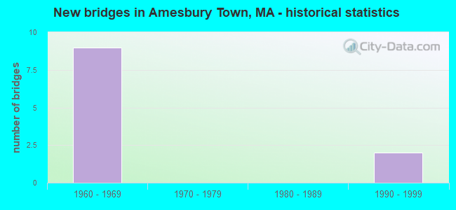
- New bridges - historical statistics
- 91960-1969
- 21990-1999


- Bridge Condition - Deck
- 14.3%Very good
- 14.3%Good
- 71.4%Fair

- Bridge Condition - Superstructure
- 14.3%Very good
- 14.3%Good
- 42.9%Satisfactory
- 28.6%Fair

- Bridge Condition - Substructure
- 14.3%Very good
- 14.3%Good
- 28.6%Satisfactory
- 42.9%Fair
Find on map >> Show street view
Structure Number: A070012QRMUNNBI, Location: JUST SOUTH NH LINE (Lat: 42.861750, Lng: -70.983239), Route carried "on" structure: City street , Year Built: 1995, Status: Open, Structure Length: 2.35m (7.71ft), Average Daily Traffic: 1,163 (year 2019), Average Future Daily Traffic: 829 (year 2032), Design Load: HS 20, Features Intersected: WATER POWWOW RIVER, Facility Carried by Structure: HWY NEWTON RD
Minimum Vertical Clearance: 30+ m (98+ ft), Kilometerpoint: 0.257, Lanes on structure: 2, Owner: Town or Township Highway Agency, Approaching Roadway Width: 6.1m (20.0ft), Skew: 1 degrees, Material/Design: Prestressed concrete, Design/Construction: Box Beam or Girders - Multiple, Number Of Spans In Main Unit: 1, Length of Maximum Span: 22.6m (74.1ft), Curb-To-Curb Width: 7.6m (24.9ft), Out-to-Out Width: 8.7m (28.5ft)
Condition: Deck: Good, Superstructure: Good, Substructure: Good, Channel: Good, Operating Rating: 87.5 metric tons, Method Used To Determine Operating Rating: Allowable Stress (AS), Inventory Rating: 42.6 metric tons, Method Used To Determine Inventory Rating: Allowable Stress (AS), Structural Evaluation: Better than present minimum criteria, Deck Geometry: Meets minimum limits, Waterway Adequacy: Superior to present desirable criteria, Approach Roadway Alignment: Equal to present desirable criteria, Length Of Structure Improvement: 2.40m (7.87ft), Designated Inspection Frequency: Every 24 months, Inspection Date: June 2021, Bridge Improvement Cost: $1,313,000, Roadway Improvement Cost: $132,000, Total Project Cost: $1,970,000 ( Estimate for 2022), Deck Structure Type: Concrete Precast Panels, Wearing Surface/Protective System: Wearing Surface: Bituminous, Membrane: Built-up
Find on map >> Show street view
Structure Number: A070022QTMUNNBI, Location: AT TREATMENT PLANT (Lat: 42.861969, Lng: -70.972456), Route carried "on" structure: City street , Year Built: 1994, Status: Open, Structure Length: 1.07m (3.51ft), Average Daily Traffic: 1,939 (year 2019), Truck Traffic: 7%, Average Future Daily Traffic: 2,448 (year 2032), Design Load: HS 20, Features Intersected: WATER POWWOW RIVER, Facility Carried by Structure: HWY NEWTON RD
Minimum Vertical Clearance: 30+ m (98+ ft), Kilometerpoint: 1.287, Lanes on structure: 2, Owner: Town or Township Highway Agency, Approaching Roadway Width: 7.3m (24.0ft), Material/Design: Prestressed concrete, Design/Construction: Slab, Number Of Spans In Main Unit: 1, Length of Maximum Span: 10.1m (33.1ft), Curb-To-Curb Width: 7.3m (24.0ft), Out-to-Out Width: 8.5m (27.9ft)
Condition: Deck: Very good, Superstructure: Very good, Substructure: Very good, Channel: Good, Operating Rating: 69.9 metric tons, Method Used To Determine Operating Rating: Allowable Stress (AS), Inventory Rating: 40.1 metric tons, Method Used To Determine Inventory Rating: Allowable Stress (AS), Structural Evaluation: Equal to present desirable criteria, Deck Geometry: Meets minimum limits, Waterway Adequacy: Somewhat better than minimum adequacy, Approach Roadway Alignment: Equal to present minimum criteria, Length Of Structure Improvement: 1.10m (3.61ft), Designated Inspection Frequency: Every 24 months, Underwater Inspection Frequency: Every 24 months, Inspection Date: November 2021, Underwater Inspection Date: April 2021, Bridge Improvement Cost: $633,000, Roadway Improvement Cost: $64,000, Total Project Cost: $950,000 ( Estimate for 2022), Deck Structure Type: Concrete Precast Panels, Wearing Surface/Protective System: Wearing Surface: Bituminous
Find on map >> Show street view
Structure Number: A070212W8DOTNBI, Location: 2.3 MI S EXIT 54 (Lat: 42.834881, Lng: -70.964958), Route carried "on" structure: Interstate 495, Year Built: 1964, Status: Temporarily open, Structure Length: 4.08m (13.39ft), Average Daily Traffic: 34,800 (year 2018), Truck Traffic: 10%, Average Future Daily Traffic: 96,410 (year 2032), Design Load: HS 20+Mod, Features Intersected: HWY MIDDLE RD
Minimum Vertical Clearance: 30+ m (98+ ft), Kilometerpoint: 187.421, Lanes on structure: 3, Lanes under structure: 2, Base Highway Network: Yes, Owner: State Highway Agency, Approaching Roadway Width: 15.2m (49.9ft), Skew: 5 degrees, Material/Design: Steel, Design/Construction: Stringer/Multi-beam, Number Of Spans In Main Unit: 3, Length of Maximum Span: 18.3m (60.0ft), Curb-To-Curb Width: 15.2m (49.9ft), Out-to-Out Width: 17.1m (56.1ft)
Condition: Deck: Fair, Superstructure: Fair, Substructure: Fair, Operating Rating: 45.4 metric tons, Method Used To Determine Operating Rating: Load Factor (LF), Inventory Rating: 27.2 metric tons, Method Used To Determine Inventory Rating: Load Factor (LF), Structural Evaluation: Somewhat better than minimum adequacy, Deck Geometry: Meets minimum limits, Underclear: Meets minimum limits, Approach Roadway Alignment: Equal to present desirable criteria, Length Of Structure Improvement: 4.10m (13.45ft), Designated Inspection Frequency: Every 24 months, Inspection Date: November 2021, Bridge Improvement Cost: $2,754,000, Roadway Improvement Cost: $276,000, Total Project Cost: $4,132,000 ( Estimate for 2022), Deck Structure Type: Concrete Cast-file-Place, Wearing Surface/Protective System: Wearing Surface: Bituminous, Membrane: Built-up
Find on map >> Show street view
Structure Number: A070212W9DOTNBI, Location: 2.3 MI S EXIT 54 (Lat: 42.834450, Lng: -70.965381), Route carried "on" structure: Interstate 495, Year Built: 1964, Status: Temporarily open, Structure Length: 4.08m (13.39ft), Average Daily Traffic: 40,300 (year 2018), Truck Traffic: 10%, Average Future Daily Traffic: 96,410 (year 2032), Design Load: HS 20+Mod, Features Intersected: HWY MIDDLE RD
Minimum Vertical Clearance: 30+ m (98+ ft), Kilometerpoint: 187.421, Lanes on structure: 3, Lanes under structure: 2, Base Highway Network: Yes, Owner: State Highway Agency, Approaching Roadway Width: 15.2m (49.9ft), Skew: 5 degrees, Material/Design: Steel, Design/Construction: Stringer/Multi-beam, Number Of Spans In Main Unit: 3, Length of Maximum Span: 18.3m (60.0ft), Curb-To-Curb Width: 15.2m (49.9ft), Out-to-Out Width: 17.1m (56.1ft)
Condition: Deck: Fair, Superstructure: Fair, Substructure: Fair, Operating Rating: 47.6 metric tons, Method Used To Determine Operating Rating: Load Factor (LF), Inventory Rating: 28.5 metric tons, Method Used To Determine Inventory Rating: Load Factor (LF), Structural Evaluation: Somewhat better than minimum adequacy, Deck Geometry: Meets minimum limits, Underclear: Meets minimum limits, Approach Roadway Alignment: Equal to present desirable criteria, Length Of Structure Improvement: 4.10m (13.45ft), Designated Inspection Frequency: Every 24 months, Inspection Date: November 2021, Bridge Improvement Cost: $2,754,000, Roadway Improvement Cost: $276,000, Total Project Cost: $4,132,000 ( Estimate for 2022), Deck Structure Type: Concrete Cast-file-Place, Wearing Surface/Protective System: Wearing Surface: Bituminous, Membrane: Built-up
Find on map >> Show street view
Structure Number: S0200731NDOTNBI, Location: .6 MI S OF NH STATE LINE (Lat: 42.873847, Lng: -70.887275), Route carried "on" structure: Ramp State highway 286, Year Built: 1967, Status: Open, Structure Length: 10.52m (34.51ft), Average Daily Traffic: 3,200 (year 2018), Truck Traffic: 10%, Average Future Daily Traffic: 4,084 (year 2033), Design Load: H 20, Features Intersected: I 95, Facility Carried by Structure: I 95 SB CONN TOLL
Minimum Vertical Clearance: 30+ m (98+ ft), Kilometerpoint: 0.949, Lanes on structure: 2, Lanes under structure: 8, Owner: State Highway Agency, Approaching Roadway Width: 6.7m (22.0ft), Skew: 4 degrees, Material/Design: Steel, Design/Construction: Stringer/Multi-beam, Number Of Spans In Main Unit: 4, Length of Maximum Span: 40.5m (132.9ft), Curb-To-Curb Width: 6.7m (22.0ft), Out-to-Out Width: 8.6m (28.2ft)
Condition: Deck: Fair, Superstructure: Satisfactory, Substructure: Satisfactory, Operating Rating: 51.4 metric tons, Method Used To Determine Operating Rating: Load Factor (LF), Inventory Rating: 30.8 metric tons, Method Used To Determine Inventory Rating: Load Factor (LF), Structural Evaluation: Equal to present minimum criteria, Deck Geometry: High priority of replacement, Underclear: Meets minimum limits, Approach Roadway Alignment: Better than present minimum criteria, Length Of Structure Improvement: 10.60m (34.78ft), Designated Inspection Frequency: Every 24 months, Inspection Date: Febuary 2022, Bridge Improvement Cost: $3,581,000, Roadway Improvement Cost: $359,000, Total Project Cost: $5,372,000 ( Estimate for 2022), Deck Structure Type: Concrete Cast-file-Place, Wearing Surface/Protective System: Wearing Surface: Bituminous, Membrane: Built-up
Find on map >> Show street view
Structure Number: S0200831PDOTNBI, Location: 1 MI S NEW HAMPSHIRE STAT (Lat: 42.867919, Lng: -70.890461), Route carried "on" structure: State highway 286, Year Built: 1967, Status: Posted for load, Structure Length: 8.78m (28.81ft), Average Daily Traffic: 3,800 (year 2020), Truck Traffic: 10%, Average Future Daily Traffic: 15,161 (year 2033), Design Load: H 20, Features Intersected: I 95
Minimum Vertical Clearance: 30+ m (98+ ft), Kilometerpoint: 0.016, Lanes on structure: 4, Lanes under structure: 8, Owner: State Highway Agency, Approaching Roadway Width: 13.4m (44.0ft), Skew: 3 degrees, Material/Design: Steel, Design/Construction: Stringer/Multi-beam, Number Of Spans In Main Unit: 2, Length of Maximum Span: 45.4m (149.0ft), Curb or Sidewalk Widths: Left: 1.0m (3.3ft), Right: 1.5m (4.9ft), Curb-To-Curb Width: 13.4m (44.0ft), Out-to-Out Width: 17.3m (56.8ft)
Condition: Deck: Fair, Superstructure: Satisfactory, Substructure: Satisfactory, Operating Rating: 87.5 metric tons, Method Used To Determine Operating Rating: Load Factor (LF), Inventory Rating: 52.4 metric tons, Method Used To Determine Inventory Rating: Load Factor (LF), Structural Evaluation: Equal to present minimum criteria, Deck Geometry: High priority of replacement, Underclear: High priority of corrective action, Approach Roadway Alignment: Equal to present desirable criteria, Length Of Structure Improvement: 8.80m (28.87ft), Designated Inspection Frequency: Every 24 months, Inspection Date: Febuary 2022, Bridge Improvement Cost: $12,002,000, Roadway Improvement Cost: $1,201,000, Total Project Cost: $18,004,000 ( Estimate for 2022), Deck Structure Type: Concrete Cast-file-Place, Wearing Surface/Protective System: Wearing Surface: Bituminous, Membrane: Built-up
Find on map >> Show street view
Structure Number: S020092XLDOTNBI, Location: AT END OF I495 (Lat: 42.856506, Lng: -70.896592), Route carried "on" structure: Interstate 495, Year Built: 1969, Status: Open, Structure Length: 10.24m (33.60ft), Average Daily Traffic: 25,862 (year 2020), Truck Traffic: 22%, Average Future Daily Traffic: 59,066 (year 2033), Design Load: HS 20, Features Intersected: I 95
Minimum Vertical Clearance: 30+ m (98+ ft), Kilometerpoint: 193.623, Lanes on structure: 2, Lanes under structure: 8, Base Highway Network: Yes, Owner: State Highway Agency, Approaching Roadway Width: 11.6m (38.1ft), Skew: 4 degrees, Material/Design: Steel, Design/Construction: Stringer/Multi-beam, Number Of Spans In Main Unit: 4, Length of Maximum Span: 37.2m (122.0ft), Curb-To-Curb Width: 11.6m (38.1ft), Out-to-Out Width: 13.4m (44.0ft)
Condition: Deck: Fair, Superstructure: Satisfactory, Substructure: Fair, Operating Rating: 56.8 metric tons, Method Used To Determine Operating Rating: Load Factor (LF), Inventory Rating: 34.0 metric tons, Method Used To Determine Inventory Rating: Load Factor (LF), Structural Evaluation: Somewhat better than minimum adequacy, Deck Geometry: Equal to present minimum criteria, Underclear: High priority of corrective action, Approach Roadway Alignment: Equal to present desirable criteria, Length Of Structure Improvement: 10.30m (33.79ft), Designated Inspection Frequency: Every 24 months, Inspection Date: Febuary 2022, Bridge Improvement Cost: $5,422,000, Roadway Improvement Cost: $543,000, Total Project Cost: $8,134,000 ( Estimate for 2022), Deck Structure Type: Concrete Cast-file-Place, Wearing Surface/Protective System: Wearing Surface: Bituminous, Membrane: Built-up
Find on map >> Show street view
Structure Number: A070272YBDOTNBI, Location: .6 MILES NORTH EXIT 55 (Lat: 42.850000, Lng: -70.900000), Route carried "under" structure: Interstate 495, Year Built: 1967, Structure Length: 0. m, Average Daily Traffic: 22,000 (year 0000), Features Intersected: I 495 NB, Facility Carried by Structure: HWY ELM ST
Minimum Vertical Clearance: 5.03m (16.50ft), Kilometerpoint: 192.289, Lanes on structure: 2, Lanes under structure: 2, Material/Design: Steel, Design/Construction: Stringer/Multi-beam, Length of Maximum Span: 18.9m (62.0ft)
Find on map >> Show street view
Structure Number: A070272YBDOTNBI, Location: .6 MILES NORTH EXIT 55 (Lat: 42.850000, Lng: -70.900000), Route carried "under" structure: Interstate 495, Year Built: 1967, Structure Length: 0. m, Average Daily Traffic: 22,000 (year 0000), Features Intersected: I 495 SB, Facility Carried by Structure: HWY ELM ST
Minimum Vertical Clearance: 5.03m (16.50ft), Kilometerpoint: 192.289, Lanes on structure: 2, Lanes under structure: 2, Material/Design: Steel, Design/Construction: Stringer/Multi-beam, Length of Maximum Span: 18.9m (62.0ft)
Find on map >> Show street view
Structure Number: S0200831PDOTNBI, Location: 1 MI S NEW HAMPSHIRE STAT (Lat: 42.866667, Lng: -70.900000), Route carried "under" structure: Interstate 95, Year Built: 1967, Structure Length: 0. m, Average Daily Traffic: 31,000 (year 0000), Features Intersected: I 95 NB, Facility Carried by Structure: ST286
Minimum Vertical Clearance: 5.33m (17.49ft), Kilometerpoint: 143.002, Lanes on structure: 4, Lanes under structure: 4, Material/Design: Steel, Design/Construction: Stringer/Multi-beam, Length of Maximum Span: 45.4m (149.0ft)
Find on map >> Show street view
Structure Number: S0200831PDOTNBI, Location: 1 MI S NEW HAMPSHIRE STAT (Lat: 42.866667, Lng: -70.900000), Route carried "under" structure: Interstate 95, Year Built: 1967, Structure Length: 0. m, Average Daily Traffic: 31,000 (year 0000), Features Intersected: I 95 SB, Facility Carried by Structure: ST286
Minimum Vertical Clearance: 5.33m (17.49ft), Kilometerpoint: 142.051, Lanes on structure: 4, Lanes under structure: 4, Material/Design: Steel, Design/Construction: Stringer/Multi-beam, Length of Maximum Span: 45.4m (149.0ft)