Bridge Statistics for Alafaya, Florida (FL)
Condition, Traffic, Stress, Structural Evaluation, Project Costs
- National Bridge Inventory (NBI) Statistics
- 26Number of bridges
- 295ft / 90.0mTotal length
- 449,660Total average daily traffic
- 26,238Total average daily truck traffic
- National Bridge Inventory (NBI) Registered Bridges for Alafaya
- No street view available for this location
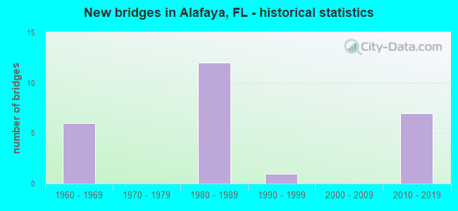
- New bridges - historical statistics
- 61960-1969
- 121980-1989
- 11990-1999
- 72010-2019

- Reconstructed bridges - Historical Statistics
- 11990-1999
- 02000-2009
- 12010-2019


- Bridge Condition - Deck
- 28.6%Very good
- 57.1%Good
- 14.3%Satisfactory

- Bridge Condition - Substructure
- 42.9%Very good
- 50.0%Good
- 7.1%Satisfactory

- Bridge Condition - Channel
- 72.7%Good
- 27.3%Satisfactory

- Bridge Condition - Culverts
- 80.0%Good
- 20.0%Satisfactory
Find on map >> Show street view
Structure Number: 750055, Location: 5.2Mi. E. of SR-417 (Lat: 28.451594, Lng: -81.145706), Route carried "on" structure: State highway 528, Year Built: 1967, Status: Open, Structure Length: 0.70m (2.30ft), Average Daily Traffic: 50,500 (year 2020), Truck Traffic: 7%, Average Future Daily Traffic: 87,618 (year 2042), Design Load: HS 20, Features Intersected: Jaspers Canal
Minimum Vertical Clearance: 30+ m (98+ ft), Kilometerpoint: 32.515, Lanes on structure: 4, Base Highway Network: Yes, Toll: On toll road, Owner: State Toll Authority, Approaching Roadway Width: 24.3m (79.7ft), Skew: 10 degrees, Material/Design: Concrete, Design/Construction: Culvert, Number Of Spans In Main Unit: 3, Length of Maximum Span: 2.1m (6.9ft)
Condition: Channel: Satisfactory, Culverts: Good, Operating Rating: 80.6 metric tons, Method Used To Determine Operating Rating: Load Factor (LF), Inventory Rating: 48.3 metric tons, Method Used To Determine Inventory Rating: Load Factor (LF), Structural Evaluation: Better than present minimum criteria, Waterway Adequacy: Equal to present minimum criteria, Approach Roadway Alignment: Equal to present desirable criteria, Designated Inspection Frequency: Every 24 months, Underwater Inspection Frequency: Every 24 months, Inspection Date: July 2020, Underwater Inspection Date: July 2020
Find on map >> Show street view
Structure Number: 750056, Location: SR-528 WB - Farm Access (Lat: 28.451694, Lng: -81.141642), Route carried "on" structure: State highway 528, Year Built: 1967, Status: Open, Structure Length: 2.51m (8.23ft), Average Daily Traffic: 25,250 (year 2020), Truck Traffic: 7%, Average Future Daily Traffic: 43,809 (year 2042), Design Load: HS 20, Features Intersected: Farm Access Road
Minimum Vertical Clearance: 30+ m (98+ ft), Kilometerpoint: 32.903, Lanes on structure: 2, Lanes under structure: 2, Base Highway Network: Yes, Toll: On toll road, Owner: State Toll Authority, Approaching Roadway Width: 11.0m (36.1ft), Skew: 20 degrees, Material/Design: Prestressed concrete continuous, Design/Construction: Stringer/Multi-beam, Number Of Spans In Main Unit: 3, Length of Maximum Span: 14.6m (47.9ft), Curb-To-Curb Width: 11.6m (38.1ft), Out-to-Out Width: 12.9m (42.3ft)
Condition: Deck: Satisfactory, Superstructure: Good, Substructure: Satisfactory, Operating Rating: 49.4 metric tons, Method Used To Determine Operating Rating: Load Factor (LF), Inventory Rating: 29.5 metric tons, Method Used To Determine Inventory Rating: Load Factor (LF), Structural Evaluation: Equal to present minimum criteria, Deck Geometry: Better than present minimum criteria, Underclear: High priority of corrective action, Approach Roadway Alignment: Equal to present desirable criteria, Designated Inspection Frequency: Every 24 months, Inspection Date: June 2020, Deck Structure Type: Concrete Cast-file-Place
Find on map >> Show street view
Structure Number: 750179, Location: SR-528 EB - Farm Access (Lat: 28.451500, Lng: -81.141661), Route carried "on" structure: State highway 528, Year Built: 1967, Status: Open, Structure Length: 2.51m (8.23ft), Average Daily Traffic: 25,250 (year 2020), Truck Traffic: 7%, Average Future Daily Traffic: 43,809 (year 2042), Design Load: HS 20, Features Intersected: Farm Access Road
Minimum Vertical Clearance: 30+ m (98+ ft), Kilometerpoint: 32.903, Lanes on structure: 2, Lanes under structure: 2, Base Highway Network: Yes, Toll: On toll road, Owner: State Toll Authority, Approaching Roadway Width: 11.0m (36.1ft), Material/Design: Prestressed concrete continuous, Design/Construction: Stringer/Multi-beam, Number Of Spans In Main Unit: 3, Length of Maximum Span: 14.6m (47.9ft), Curb-To-Curb Width: 11.6m (38.1ft), Out-to-Out Width: 12.9m (42.3ft)
Condition: Deck: Satisfactory, Superstructure: Good, Substructure: Good, Operating Rating: 49.4 metric tons, Method Used To Determine Operating Rating: Load Factor (LF), Inventory Rating: 29.6 metric tons, Method Used To Determine Inventory Rating: Load Factor (LF), Structural Evaluation: Better than present minimum criteria, Deck Geometry: Better than present minimum criteria, Underclear: High priority of corrective action, Approach Roadway Alignment: Equal to present desirable criteria, Designated Inspection Frequency: Every 24 months, Inspection Date: June 2020, Deck Structure Type: Concrete Cast-file-Place
Find on map >> Show street view
Structure Number: 7503, Location: 8.7 Miles East of CR-15 (Lat: 28.451447, Lng: -81.121864), Route carried "on" structure: State highway 528, Year Built: 1967, Status: Open, Structure Length: 0.64m (2.10ft), Average Daily Traffic: 50,500 (year 2020), Truck Traffic: 7%, Average Future Daily Traffic: 87,618 (year 2042), Design Load: HS 20, Features Intersected: Turkey Creek
Minimum Vertical Clearance: 30+ m (98+ ft), Kilometerpoint: 34.849, Lanes on structure: 4, Base Highway Network: Yes, Toll: On toll road, Owner: State Toll Authority, Approaching Roadway Width: 23.7m (77.8ft), Skew: 10 degrees, Material/Design: Concrete, Design/Construction: Culvert, Number Of Spans In Main Unit: 2, Length of Maximum Span: 3.3m (10.8ft)
Condition: Channel: Good, Culverts: Satisfactory, Operating Rating: 61.4 metric tons, Method Used To Determine Operating Rating: Load Factor (LF), Inventory Rating: 36.8 metric tons, Method Used To Determine Inventory Rating: Load Factor (LF), Structural Evaluation: Equal to present minimum criteria, Waterway Adequacy: Equal to present minimum criteria, Approach Roadway Alignment: Equal to present desirable criteria, Designated Inspection Frequency: Every 24 months, Underwater Inspection Frequency: Every 24 months, Inspection Date: July 2020, Underwater Inspection Date: July 2020
Find on map >> Show street view
Structure Number: 750332, Location: SR-528 WB - OUCRR & Rd (Lat: 28.451750, Lng: -81.161067), Route carried "on" structure: State highway 528, Year Built: 1984, Status: Open, Structure Length: 6.00m (19.69ft), Average Daily Traffic: 30,500 (year 2020), Truck Traffic: 6%, Average Future Daily Traffic: 52,918 (year 2042), Design Load: HS 20+Mod, Features Intersected: OUCRR & Access Road
Minimum Vertical Clearance: 30+ m (98+ ft), Kilometerpoint: 30.990, Lanes on structure: 2, Lanes under structure: 5, Base Highway Network: Yes, Toll: On toll road, Owner: State Toll Authority, Approaching Roadway Width: 11.0m (36.1ft), Material/Design: Prestressed concrete, Design/Construction: Stringer/Multi-beam, Number Of Spans In Main Unit: 4, Length of Maximum Span: 19.8m (65.0ft), Curb-To-Curb Width: 12.2m (40.0ft), Out-to-Out Width: 13.1m (43.0ft)
Condition: Deck: Good, Superstructure: Good, Substructure: Good, Operating Rating: 66.1 metric tons, Method Used To Determine Operating Rating: Load Factor (LF), Inventory Rating: 39.6 metric tons, Method Used To Determine Inventory Rating: Load Factor (LF), Structural Evaluation: Better than present minimum criteria, Deck Geometry: Better than present minimum criteria, Underclear: High priority of corrective action, Approach Roadway Alignment: Equal to present desirable criteria, Designated Inspection Frequency: Every 24 months, Inspection Date: July 2020, Deck Structure Type: Concrete Cast-file-Place
Find on map >> Show street view
Structure Number: 750333, Location: 4.2 Mi. E of SR-417 (Lat: 28.451581, Lng: -81.161092), Route carried "on" structure: State highway 528, Year Built: 1984, Year Reconstructed: 2017, Status: Open, Structure Length: 5.94m (19.49ft), Average Daily Traffic: 30,500 (year 2020), Truck Traffic: 6%, Average Future Daily Traffic: 52,918 (year 2042), Design Load: HL 93, Features Intersected: OUCRR & ICP Access Rd
Minimum Vertical Clearance: 30+ m (98+ ft), Kilometerpoint: 30.990, Lanes on structure: 3, Lanes under structure: 5, Base Highway Network: Yes, Toll: On toll road, Owner: State Toll Authority, Approaching Roadway Width: 13.9m (45.6ft), Material/Design: Prestressed concrete, Design/Construction: Stringer/Multi-beam, Number Of Spans In Main Unit: 4, Length of Maximum Span: 19.8m (65.0ft), Curb-To-Curb Width: 15.8m (51.8ft), Out-to-Out Width: 16.8m (55.1ft)
Condition: Deck: Good, Superstructure: Good, Substructure: Good, Operating Rating: 48.0 metric tons, Method Used To Determine Operating Rating: Load and Resistance Factor (LRFR), Inventory Rating: 37.0 metric tons, Method Used To Determine Inventory Rating: Load and Resistance Factor (LRFR), Structural Evaluation: Better than present minimum criteria, Deck Geometry: Better than present minimum criteria, Underclear: High priority of corrective action, Approach Roadway Alignment: Equal to present desirable criteria, Designated Inspection Frequency: Every 24 months, Inspection Date: July 2020, Deck Structure Type: Concrete Cast-file-Place
Find on map >> Show street view
Structure Number: 750848, Location: SR-50 WB over Econ River (Lat: 28.565483, Lng: -81.154061), Route carried "on" structure: State highway 50, Year Built: 2017, Status: Open, Structure Length: 10.61m (34.81ft), Average Daily Traffic: 20,500 (year 2020), Truck Traffic: 6%, Average Future Daily Traffic: 35,465 (year 2042), Design Load: HL 93, Features Intersected: Econlockhatchee River
Minimum Vertical Clearance: 30+ m (98+ ft), Kilometerpoint: 24.065, Lanes on structure: 2, Base Highway Network: Yes, Owner: State Highway Agency, Approaching Roadway Width: 15.4m (50.5ft), Material/Design: Prestressed concrete, Design/Construction: Stringer/Multi-beam, Number Of Spans In Main Unit: 4, Length of Maximum Span: 26.4m (86.6ft), Curb or Sidewalk Widths: Left: 1.8m (5.9ft), Right: 0.0m, Curb-To-Curb Width: 15.4m (50.5ft), Out-to-Out Width: 18.6m (61.0ft)
Condition: Deck: Good, Superstructure: Good, Substructure: Very good, Channel: Good, Operating Rating: 41.2 metric tons, Method Used To Determine Operating Rating: Load and Resistance Factor (LRFR), Inventory Rating: 37.6 metric tons, Method Used To Determine Inventory Rating: Load and Resistance Factor (LRFR), Structural Evaluation: Better than present minimum criteria, Deck Geometry: Superior to present desirable criteria, Waterway Adequacy: Equal to present desirable criteria, Approach Roadway Alignment: Equal to present desirable criteria, Designated Inspection Frequency: Every 24 months, Underwater Inspection Frequency: Every 24 months, Inspection Date: May 2021, Underwater Inspection Date: May 2021, Deck Structure Type: Concrete Cast-file-Place, Wearing Surface/Protective System: Wearing Surface: Monolithic Concrete
Find on map >> Show street view
Structure Number: 750849, Location: SR-50 EB Econ River (Lat: 28.565283, Lng: -81.154028), Route carried "on" structure: State highway 50, Year Built: 2016, Status: Open, Structure Length: 10.61m (34.81ft), Average Daily Traffic: 20,500 (year 2020), Truck Traffic: 6%, Average Future Daily Traffic: 35,465 (year 2042), Design Load: HL 93, Features Intersected: Econlockhatchee River
Minimum Vertical Clearance: 30+ m (98+ ft), Kilometerpoint: 24.065, Lanes on structure: 2, Base Highway Network: Yes, Owner: State Highway Agency, Approaching Roadway Width: 15.4m (50.5ft), Material/Design: Prestressed concrete, Design/Construction: Stringer/Multi-beam, Number Of Spans In Main Unit: 4, Length of Maximum Span: 26.4m (86.6ft), Curb or Sidewalk Widths: Left: 0.0m, Right: 1.8m (5.9ft), Curb-To-Curb Width: 15.4m (50.5ft), Out-to-Out Width: 18.6m (61.0ft)
Condition: Deck: Good, Superstructure: Good, Substructure: Very good, Channel: Good, Operating Rating: 41.2 metric tons, Method Used To Determine Operating Rating: Load and Resistance Factor (LRFR), Inventory Rating: 37.6 metric tons, Method Used To Determine Inventory Rating: Load and Resistance Factor (LRFR), Structural Evaluation: Better than present minimum criteria, Deck Geometry: Superior to present desirable criteria, Waterway Adequacy: Equal to present desirable criteria, Approach Roadway Alignment: Equal to present desirable criteria, Designated Inspection Frequency: Every 24 months, Underwater Inspection Frequency: Every 24 months, Inspection Date: May 2021, Underwater Inspection Date: May 2021, Deck Structure Type: Concrete Cast-file-Place, Wearing Surface/Protective System: Wearing Surface: Monolithic Concrete
Find on map >> Show street view
Structure Number: 754065, Location: 2.9 mi. East of SR-551 (Lat: 28.510064, Lng: -81.244158), Route carried "on" structure: Alternate County highway 552, Year Built: 1980, Year Reconstructed: 2001, Status: Open, Structure Length: 5.76m (18.90ft), Average Daily Traffic: 33,000 (year 2021), Truck Traffic: 3%, Average Future Daily Traffic: 57,255 (year 2042), Design Load: HS 20, Features Intersected: Little Econ River, Facility Carried by Structure: Curry Ford Road
Minimum Vertical Clearance: 30+ m (98+ ft), Kilometerpoint: 8.871, Lanes on structure: 6, Owner: County Highway Agency, Approaching Roadway Width: 27.2m (89.2ft), Skew: 20 degrees, Material/Design: Prestressed concrete, Design/Construction: Stringer/Multi-beam, Number Of Spans In Main Unit: 3, Length of Maximum Span: 19.2m (63.0ft), Curb or Sidewalk Widths: Left: 2.1m (6.9ft), Right: 2.1m (6.9ft), Curb-To-Curb Width: 27.2m (89.2ft), Out-to-Out Width: 43.2m (141.7ft)
Condition: Deck: Good, Superstructure: Good, Substructure: Good, Channel: Good, Operating Rating: 61.5 metric tons, Method Used To Determine Operating Rating: Load Factor (LF), Inventory Rating: 36.9 metric tons, Method Used To Determine Inventory Rating: Load Factor (LF), Structural Evaluation: Better than present minimum criteria, Deck Geometry: Better than present minimum criteria, Waterway Adequacy: Better than present minimum criteria, Approach Roadway Alignment: Better than present minimum criteria, Designated Inspection Frequency: Every 24 months, Underwater Inspection Frequency: Every 24 months, Inspection Date: October 2021, Underwater Inspection Date: October 2021, Deck Structure Type: Concrete Cast-file-Place
Find on map >> Show street view
Structure Number: 754076, Location: 0.2 mile S of Avalon Park (Lat: 28.564478, Lng: -81.162053), Route carried "on" structure: County highway , Year Built: 1987, Status: Open, Structure Length: 1.01m (3.31ft), Average Daily Traffic: 2,076 (year 2021), Truck Traffic: 5%, Average Future Daily Traffic: 2,408 (year 2042), Design Load: HS 20, Features Intersected: Canal, Facility Carried by Structure: Old Cheney Hwy
Minimum Vertical Clearance: 30+ m (98+ ft), Kilometerpoint: 0.000, Lanes on structure: 2, Owner: County Highway Agency, Approaching Roadway Width: 10.5m (34.4ft), Material/Design: Prestressed concrete, Design/Construction: Slab, Number Of Spans In Main Unit: 1, Length of Maximum Span: 10.1m (33.1ft), Curb or Sidewalk Widths: Left: 0.0m, Right: 2.1m (6.9ft), Curb-To-Curb Width: 10.5m (34.4ft), Out-to-Out Width: 13.5m (44.3ft)
Condition: Deck: Good, Superstructure: Good, Substructure: Good, Channel: Satisfactory, Operating Rating: 45.1 metric tons, Method Used To Determine Operating Rating: Load Factor (LF), Inventory Rating: 27.1 metric tons, Method Used To Determine Inventory Rating: Load Factor (LF), Structural Evaluation: Equal to present minimum criteria, Deck Geometry: Somewhat better than minimum adequacy, Waterway Adequacy: Equal to present desirable criteria, Approach Roadway Alignment: Equal to present desirable criteria, Designated Inspection Frequency: Every 24 months, Inspection Date: October 2021, Deck Structure Type: Concrete Precast Panels, Wearing Surface/Protective System: Wearing Surface: Bituminous
Find on map >> Show street view
Structure Number: 754082, Location: .4 Mi S of Lk Undrhill Rd (Lat: 28.534089, Lng: -81.242631), Route carried "on" structure: County highway 552, Year Built: 1989, Status: Open, Structure Length: 7.32m (24.02ft), Average Daily Traffic: 15,500 (year 2021), Truck Traffic: 2%, Average Future Daily Traffic: 26,893 (year 2042), Design Load: HS 20, Features Intersected: High Point Outfall Canal, Facility Carried by Structure: Dean Road
Minimum Vertical Clearance: 30+ m (98+ ft), Kilometerpoint: 12.332, Lanes on structure: 2, Owner: County Highway Agency, Approaching Roadway Width: 8.0m (26.2ft), Skew: 4 degrees, Material/Design: Prestressed concrete, Design/Construction: Stringer/Multi-beam, Number Of Spans In Main Unit: 2, Length of Maximum Span: 36.6m (120.1ft), Curb-To-Curb Width: 12.2m (40.0ft), Out-to-Out Width: 13.1m (43.0ft)
Condition: Deck: Good, Superstructure: Good, Substructure: Good, Channel: Good, Operating Rating: 48.4 metric tons, Method Used To Determine Operating Rating: Allowable Stress (AS), Inventory Rating: 40.8 metric tons, Method Used To Determine Inventory Rating: Allowable Stress (AS), Structural Evaluation: Better than present minimum criteria, Deck Geometry: Somewhat better than minimum adequacy, Waterway Adequacy: Equal to present minimum criteria, Approach Roadway Alignment: Equal to present desirable criteria, Designated Inspection Frequency: Every 24 months, Inspection Date: November 2021, Deck Structure Type: Concrete Cast-file-Place
Find on map >> Show street view
Structure Number: 754088, Location: 0.1 Mi South of SR-408 (Lat: 28.545278, Lng: -81.244278), Route carried "on" structure: County highway 552, Year Built: 1989, Status: Open, Structure Length: 0.76m (2.49ft), Average Daily Traffic: 15,500 (year 2021), Truck Traffic: 2%, Average Future Daily Traffic: 26,893 (year 2042), Design Load: HS 20, Features Intersected: Canal, Facility Carried by Structure: Dean Road
Minimum Vertical Clearance: 30+ m (98+ ft), Kilometerpoint: 0.000, Lanes on structure: 4, Owner: County Highway Agency, Approaching Roadway Width: 17.0m (55.8ft), Skew: 11 degrees, Material/Design: Concrete, Design/Construction: Culvert, Number Of Spans In Main Unit: 2, Length of Maximum Span: 3.7m (12.1ft)
Condition: Channel: Good, Culverts: Good, Operating Rating: 50.6 metric tons, Method Used To Determine Operating Rating: Load Factor (LF), Inventory Rating: 30.4 metric tons, Method Used To Determine Inventory Rating: Load Factor (LF), Structural Evaluation: Better than present minimum criteria, Waterway Adequacy: Superior to present desirable criteria, Approach Roadway Alignment: Equal to present desirable criteria, Designated Inspection Frequency: Every 24 months, Inspection Date: November 2021
Find on map >> Show street view
Structure Number: 754089, Location: W Side Dean Rd at SR-408 (Lat: 28.545383, Lng: -81.244706), Route carried "on" structure: ServiceCounty highway , Year Built: 1989, Status: Open, Structure Length: 0.72m (2.36ft), Average Daily Traffic: 1 (year 2021), Truck Traffic: 2%, Average Future Daily Traffic: 24 (year 2042), Design Load: HS 20, Features Intersected: Drainage Canal, Facility Carried by Structure: Dean Service Road
Minimum Vertical Clearance: 30+ m (98+ ft), Kilometerpoint: 0.000, Lanes on structure: 2, Owner: County Highway Agency, Approaching Roadway Width: 7.3m (24.0ft), Skew: 2 degrees, Material/Design: Concrete, Design/Construction: Culvert, Number Of Spans In Main Unit: 2, Length of Maximum Span: 3.4m (11.2ft), Curb-To-Curb Width: 12.4m (40.7ft), Out-to-Out Width: 13.2m (43.3ft)
Condition: Channel: Good, Culverts: Good, Operating Rating: 54.9 metric tons, Method Used To Determine Operating Rating: Load and Resistance Factor (LRFR), Inventory Rating: 42.5 metric tons, Method Used To Determine Inventory Rating: Load and Resistance Factor (LRFR), Structural Evaluation: Better than present minimum criteria, Deck Geometry: Superior to present desirable criteria, Waterway Adequacy: Superior to present desirable criteria, Approach Roadway Alignment: Equal to present desirable criteria, Designated Inspection Frequency: Every 24 months, Underwater Inspection Frequency: Every 24 months, Inspection Date: October 2021, Underwater Inspection Date: October 2021, Deck Structure Type: Concrete Cast-file-Place, Wearing Surface/Protective System: Wearing Surface: Bituminous
Find on map >> Show street view
Structure Number: 75409, Location: 30ftN of Lake Undrhill Rd (Lat: 28.547094, Lng: -81.203842), Route carried "on" structure: County highway , Year Built: 1988, Status: Open, Structure Length: 0.63m (2.07ft), Average Daily Traffic: 48,500 (year 2021), Truck Traffic: 6%, Average Future Daily Traffic: 84,148 (year 2042), Design Load: HS 20, Features Intersected: Canal, Facility Carried by Structure: Alafaya Trail
Minimum Vertical Clearance: 30+ m (98+ ft), Kilometerpoint: 0.000, Lanes on structure: 8, Owner: County Highway Agency, Approaching Roadway Width: 30.4m (99.7ft), Material/Design: Concrete, Design/Construction: Culvert, Number Of Spans In Main Unit: 2, Length of Maximum Span: 3.0m (9.8ft)
Condition: Channel: Good, Culverts: Good, Operating Rating: 40.4 metric tons, Method Used To Determine Operating Rating: Load Factor (LF), Inventory Rating: 24.2 metric tons, Method Used To Determine Inventory Rating: Load Factor (LF), Structural Evaluation: Somewhat better than minimum adequacy, Waterway Adequacy: Superior to present desirable criteria, Approach Roadway Alignment: Equal to present desirable criteria, Designated Inspection Frequency: Every 24 months, Inspection Date: November 2021
Find on map >> Show street view
Structure Number: 754113, Location: 0.25 Mi. South of SR-50 (Lat: 28.561928, Lng: -81.184006), Route carried "on" structure: County highway , Year Built: 1999, Status: Open, Structure Length: 3.75m (12.30ft), Average Daily Traffic: 1,275 (year 2020), Truck Traffic: 5%, Average Future Daily Traffic: 1,479 (year 2042), Design Load: HS 20, Features Intersected: Canal, Facility Carried by Structure: Bridgeway Blvd.
Minimum Vertical Clearance: 30+ m (98+ ft), Kilometerpoint: 0.016, Lanes on structure: 2, Owner: County Highway Agency, Approaching Roadway Width: 12.0m (39.4ft), Material/Design: Prestressed concrete, Design/Construction: Slab, Number Of Spans In Main Unit: 3, Length of Maximum Span: 12.2m (40.0ft), Curb or Sidewalk Widths: Left: 1.5m (4.9ft), Right: 0.0m, Curb-To-Curb Width: 12.0m (39.4ft), Out-to-Out Width: 15.2m (49.9ft)
Condition: Deck: Good, Superstructure: Good, Substructure: Good, Channel: Satisfactory, Operating Rating: 55.3 metric tons, Method Used To Determine Operating Rating: Load Factor (LF), Inventory Rating: 32.7 metric tons, Method Used To Determine Inventory Rating: Load Factor (LF), Structural Evaluation: Better than present minimum criteria, Deck Geometry: Equal to present minimum criteria, Waterway Adequacy: Superior to present desirable criteria, Approach Roadway Alignment: Equal to present desirable criteria, Designated Inspection Frequency: Every 24 months, Inspection Date: November 2020, Deck Structure Type: Concrete Precast Panels, Wearing Surface/Protective System: Wearing Surface: Bituminous
Find on map >> Show street view
Structure Number: 754163, Location: 3.5 Miles East of SR 417 (Lat: 28.450000, Lng: -81.173333), Route carried "on" structure: Ramp State highway 528, Year Built: 2017, Status: Open, Structure Length: 9.31m (30.54ft), Average Daily Traffic: 4,900 (year 2020), Truck Traffic: 6%, Average Future Daily Traffic: 8,502 (year 2042), Design Load: HL 93, Features Intersected: AAF RR
Minimum Vertical Clearance: 30.45m (99.90ft), Kilometerpoint: 0.325, Lanes on structure: 2, Base Highway Network: Yes, Owner: State Toll Authority, Approaching Roadway Width: 12.2m (40.0ft), Material/Design: Prestressed concrete, Design/Construction: Stringer/Multi-beam, Number Of Spans In Main Unit: 2, Length of Maximum Span: 48.2m (158.1ft), Curb-To-Curb Width: 12.2m (40.0ft), Out-to-Out Width: 13.1m (43.0ft)
Condition: Deck: Very good, Superstructure: Good, Substructure: Very good, Operating Rating: 55.6 metric tons, Method Used To Determine Operating Rating: Load and Resistance Factor (LRFR), Inventory Rating: 38.3 metric tons, Method Used To Determine Inventory Rating: Load and Resistance Factor (LRFR), Structural Evaluation: Better than present minimum criteria, Deck Geometry: Superior to present desirable criteria, Approach Roadway Alignment: Better than present minimum criteria, Designated Inspection Frequency: Every 24 months, Inspection Date: October 2021, Deck Structure Type: Concrete Cast-file-Place
Find on map >> Show street view
Structure Number: 754164, Location: 0.1 Mi. E of Innov. Way (Lat: 28.450917, Lng: -81.168111), Route carried "on" structure: Ramp State highway 528, Year Built: 2018, Status: Open, Structure Length: 10.48m (34.38ft), Average Daily Traffic: 1,400 (year 2020), Truck Traffic: 6%, Average Future Daily Traffic: 2,429 (year 2042), Design Load: HL 93, Features Intersected: AAF RR, Facility Carried by Structure: Ramp C
Minimum Vertical Clearance: 30+ m (98+ ft), Kilometerpoint: 0.169, Lanes on structure: 2, Toll: On toll road, Owner: State Toll Authority, Approaching Roadway Width: 12.2m (40.0ft), Material/Design: Prestressed concrete, Design/Construction: Stringer/Multi-beam, Number Of Spans In Main Unit: 2, Length of Maximum Span: 53.8m (176.5ft), Curb-To-Curb Width: 12.2m (40.0ft), Out-to-Out Width: 13.1m (43.0ft)
Condition: Deck: Very good, Superstructure: Good, Substructure: Very good, Operating Rating: 65.7 metric tons, Method Used To Determine Operating Rating: Load and Resistance Factor (LRFR), Inventory Rating: 44.5 metric tons, Method Used To Determine Inventory Rating: Load and Resistance Factor (LRFR), Structural Evaluation: Better than present minimum criteria, Deck Geometry: Superior to present desirable criteria, Approach Roadway Alignment: Better than present minimum criteria, Designated Inspection Frequency: Every 24 months, Inspection Date: October 2021, Deck Structure Type: Concrete Cast-file-Place
Find on map >> Show street view
Structure Number: 754165, Location: 0.7Mi S of Monument Pkwy (Lat: 28.451611, Lng: -81.170444), Route carried "on" structure: Other road , Year Built: 2018, Status: Open, Structure Length: 7.25m (23.79ft), Average Daily Traffic: 1,200 (year 2018), Truck Traffic: 2%, Average Future Daily Traffic: 2,082 (year 2040), Design Load: HL 93, Features Intersected: SR-528, Facility Carried by Structure: Innovation Way
Minimum Vertical Clearance: 30+ m (98+ ft), Kilometerpoint: 0.000, Lanes on structure: 8, Lanes under structure: 6, Base Highway Network: Yes, Toll: On toll road, Owner: State Toll Authority, Approaching Roadway Width: 31.7m (104.0ft), Skew: 30 degrees, Material/Design: Prestressed concrete, Design/Construction: Stringer/Multi-beam, Number Of Spans In Main Unit: 2, Length of Maximum Span: 38.9m (127.6ft), Curb or Sidewalk Widths: Left: 1.5m (4.9ft), Right: 1.5m (4.9ft), Curb-To-Curb Width: 31.7m (104.0ft), Out-to-Out Width: 46.8m (153.5ft)
Condition: Deck: Very good, Superstructure: Good, Substructure: Very good, Operating Rating: 55.4 metric tons, Method Used To Determine Operating Rating: Load and Resistance Factor (LRFR), Inventory Rating: 38.5 metric tons, Method Used To Determine Inventory Rating: Load and Resistance Factor (LRFR), Structural Evaluation: Better than present minimum criteria, Deck Geometry: Somewhat better than minimum adequacy, Underclear: Superior to present desirable criteria, Approach Roadway Alignment: Equal to present desirable criteria, Designated Inspection Frequency: Every 24 months, Inspection Date: October 2021, Deck Structure Type: Concrete Cast-file-Place
Find on map >> Show street view
Structure Number: 754166, Location: 0.75Mi S of Monument Pkwy (Lat: 28.450972, Lng: -81.170361), Route carried "on" structure: State highway , Year Built: 2018, Status: Open, Structure Length: 3.54m (11.61ft), Average Daily Traffic: 1,200 (year 2018), Truck Traffic: 2%, Average Future Daily Traffic: 2,082 (year 2040), Design Load: HL 93, Features Intersected: AAF RR, Facility Carried by Structure: Innovation Way
Minimum Vertical Clearance: 30+ m (98+ ft), Kilometerpoint: 0.000, Lanes on structure: 8, Base Highway Network: Yes, Owner: State Toll Authority, Approaching Roadway Width: 31.7m (104.0ft), Skew: 30 degrees, Material/Design: Prestressed concrete, Design/Construction: Stringer/Multi-beam, Number Of Spans In Main Unit: 1, Length of Maximum Span: 35.4m (116.1ft), Curb or Sidewalk Widths: Left: 1.5m (4.9ft), Right: 1.5m (4.9ft), Curb-To-Curb Width: 31.7m (104.0ft), Out-to-Out Width: 46.8m (153.5ft)
Condition: Deck: Very good, Superstructure: Good, Substructure: Very good, Operating Rating: 51.8 metric tons, Method Used To Determine Operating Rating: Load and Resistance Factor (LRFR), Inventory Rating: 37.2 metric tons, Method Used To Determine Inventory Rating: Load and Resistance Factor (LRFR), Structural Evaluation: Better than present minimum criteria, Deck Geometry: Somewhat better than minimum adequacy, Approach Roadway Alignment: Equal to present desirable criteria, Designated Inspection Frequency: Every 24 months, Inspection Date: October 2021, Deck Structure Type: Concrete Cast-file-Place
Find on map >> Show street view
Structure Number: 750056, Location: SR-528 WB - Farm Access (Lat: 28.451694, Lng: -81.141642), Route carried "under" structure: ServiceCounty highway , Year Built: 1967, Structure Length: 0. m, Average Daily Traffic: 4 (year 2020), Features Intersected: Farm Access Road, Facility Carried by Structure: SR-528 WB
Minimum Vertical Clearance: 3.78m (12.40ft), Kilometerpoint: 0.000, Lanes on structure: 2, Lanes under structure: 2, Material/Design: Prestressed concrete continuous, Design/Construction: Stringer/Multi-beam, Length of Maximum Span: 14.6m (47.9ft)
Find on map >> Show street view
Structure Number: 750179, Location: SR-528 EB - Farm Access (Lat: 28.451500, Lng: -81.141661), Route carried "under" structure: ServiceCounty highway , Year Built: 1967, Structure Length: 0. m, Average Daily Traffic: 4 (year 2020), Features Intersected: Farm Access Road, Facility Carried by Structure: SR-528
Minimum Vertical Clearance: 3.78m (12.40ft), Kilometerpoint: 0.000, Lanes on structure: 2, Lanes under structure: 2, Material/Design: Prestressed concrete continuous, Design/Construction: Stringer/Multi-beam, Length of Maximum Span: 14.6m (47.9ft)
Find on map >> Show street view
Structure Number: 750332, Location: SR-528 WB - OUCRR & Rd (Lat: 28.451750, Lng: -81.161067), Route carried "under" structure: ServiceOther road , Year Built: 1984, Structure Length: 0. m, Average Daily Traffic: 1,300 (year 2020), Truck Traffic: 7%, Features Intersected: OUCRR & Access Road, Facility Carried by Structure: SR-528
Minimum Vertical Clearance: 6.92m (22.70ft), Kilometerpoint: 0.457, Lanes on structure: 2, Lanes under structure: 4, Material/Design: Prestressed concrete, Design/Construction: Stringer/Multi-beam, Length of Maximum Span: 19.8m (65.0ft)
Find on map >> Show street view
Structure Number: 750332, Location: SR-528 WB - OUCRR & Rd (Lat: 28.451750, Lng: -81.161067), Route carried "under" structure: Ramp Other road , Year Built: 1984, Structure Length: 0. m, Average Daily Traffic: 4,000 (year 2020), Truck Traffic: 7%, Features Intersected: OUCRR & Access Road, Facility Carried by Structure: SR-528
Minimum Vertical Clearance: 6.07m (19.91ft), Kilometerpoint: 1.271, Lanes on structure: 2, Lanes under structure: 1, Material/Design: Prestressed concrete, Design/Construction: Stringer/Multi-beam, Length of Maximum Span: 19.8m (65.0ft)
Find on map >> Show street view
Structure Number: 750333, Location: 4.2 Mi. E of SR-417 (Lat: 28.451581, Lng: -81.161092), Route carried "under" structure: ServiceOther road , Year Built: 1984, Structure Length: 0. m, Average Daily Traffic: 1,300 (year 2020), Truck Traffic: 7%, Features Intersected: OUCRR & ICP Access Rd, Facility Carried by Structure: SR-528
Minimum Vertical Clearance: 6.07m (19.91ft), Kilometerpoint: 0.480, Lanes on structure: 3, Lanes under structure: 4, Material/Design: Prestressed concrete, Design/Construction: Stringer/Multi-beam, Length of Maximum Span: 19.8m (65.0ft)
Find on map >> Show street view
Structure Number: 750333, Location: 4.2 Mi. E of SR-417 (Lat: 28.451581, Lng: -81.161092), Route carried "under" structure: Ramp Other road , Year Built: 1984, Structure Length: 0. m, Average Daily Traffic: 4,000 (year 2020), Truck Traffic: 7%, Features Intersected: OUCRR & ICP Access Rd, Facility Carried by Structure: SR-528
Minimum Vertical Clearance: 6.07m (19.91ft), Kilometerpoint: 1.247, Lanes on structure: 3, Lanes under structure: 1, Material/Design: Prestressed concrete, Design/Construction: Stringer/Multi-beam, Length of Maximum Span: 19.8m (65.0ft)
Find on map >> Show street view
Structure Number: 754165, Location: 0.7Mi S of Monument Pkwy (Lat: 28.451611, Lng: -81.170444), Route carried "under" structure: State highway 528, Year Built: 2018, Structure Length: 0. m, Average Daily Traffic: 61,000 (year 2020), Truck Traffic: 6%, Features Intersected: SR-528, Facility Carried by Structure: Innovation Way
Minimum Vertical Clearance: 6.89m (22.60ft), Kilometerpoint: 30.063, Lanes on structure: 8, Lanes under structure: 6, Toll: On toll road, Material/Design: Prestressed concrete, Design/Construction: Stringer/Multi-beam, Length of Maximum Span: 38.9m (127.6ft)