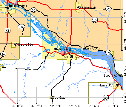
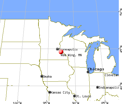
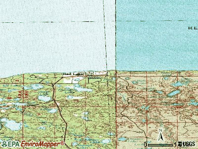
Red Wing, Minnesota

Red Wing: On Barns Bluff looking North
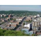
Red Wing: Red Wing Down Town View west
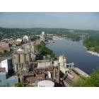
Red Wing: Red Wing Mississippi east to west bend
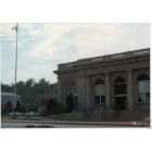
Red Wing: POST OFFICE
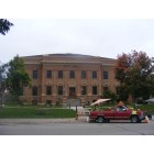
Red Wing: Red Wing City Hall

Red Wing: Levee Park taken from St. James Hotel

Red Wing: Enterance at Memorial Park
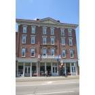
Red Wing: Historic St. James Hotel in downtown Red Wing, MN.

Red Wing: On Barns Bluff towards city
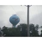
Red Wing: Red Wing Water Tower
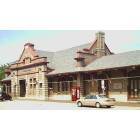
Red Wing: Train Station at Redwing, Mn.
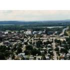
Red Wing: East end of Red Wing taken from Memorial Park
- add
your
Submit your own pictures of this city and show them to the world
- OSM Map
- General Map
- Google Map
- MSN Map
Population change since 2000: +3.4%
 |
| Males: 8,373 | |
| Females: 8,299 |
| Median resident age: | 43.0 years |
| Minnesota median age: | 39.0 years |
Zip codes: 55089.
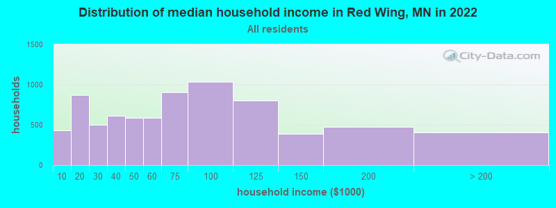
| Red Wing: | $63,582 |
| MN: | $82,338 |
Estimated per capita income in 2022: $38,161 (it was $21,678 in 2000)
Red Wing city income, earnings, and wages data
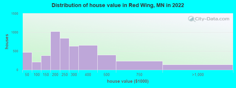
Estimated median house or condo value in 2022: $233,317 (it was $108,200 in 2000)
| Red Wing: | $233,317 |
| MN: | $314,600 |
Mean prices in 2022: all housing units: $250,955; detached houses: $265,001; townhouses or other attached units: $246,431; in 2-unit structures: $503,899; in 3-to-4-unit structures: $220,773; in 5-or-more-unit structures: $174,474; mobile homes: $47,609
Median gross rent in 2022: $926.
(10.9% for White Non-Hispanic residents, 71.9% for Black residents, 5.7% for Hispanic or Latino residents, 23.1% for American Indian residents, 0.5% for other race residents, 6.2% for two or more races residents)
Detailed information about poverty and poor residents in Red Wing, MN


- 14,27185.5%White alone
- 9155.5%Hispanic
- 5203.1%Black alone
- 4072.4%Two or more races
- 2491.5%American Indian alone
- 1320.8%Asian alone
- 230.1%Other race alone
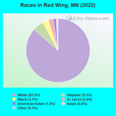
Races in Red Wing detailed stats: ancestries, foreign born residents, place of birth
According to our research of Minnesota and other state lists, there were 4 registered sex offenders living in Red Wing, Minnesota as of June 10, 2024.
The ratio of all residents to sex offenders in Red Wing is 4,173 to 1.
Type |
2009 |
2010 |
2011 |
2012 |
2013 |
2014 |
2015 |
2016 |
2017 |
2018 |
2019 |
2020 |
2021 |
2022 |
|---|---|---|---|---|---|---|---|---|---|---|---|---|---|---|
| Murders (per 100,000) | 0 (0.0) | 0 (0.0) | 0 (0.0) | 0 (0.0) | 0 (0.0) | 0 (0.0) | 0 (0.0) | 0 (0.0) | 1 (6.0) | 1 (6.1) | 1 (6.1) | 0 (0.0) | 0 (0.0) | 0 (0.0) |
| Rapes (per 100,000) | 6 (38.4) | 10 (60.8) | 6 (36.2) | 4 (24.1) | 14 (84.9) | 12 (72.6) | 18 (109.3) | 8 (48.7) | 8 (48.4) | 11 (67.1) | 3 (18.3) | 15 (92.0) | 11 (67.0) | 10 (59.0) |
| Robberies (per 100,000) | 4 (25.6) | 2 (12.2) | 6 (36.2) | 6 (36.2) | 2 (12.1) | 2 (12.1) | 3 (18.2) | 6 (36.5) | 6 (36.3) | 5 (30.5) | 4 (24.4) | 4 (24.5) | 1 (6.1) | 1 (5.9) |
| Assaults (per 100,000) | 19 (121.5) | 16 (97.2) | 22 (132.6) | 26 (156.8) | 19 (115.2) | 22 (133.1) | 24 (145.7) | 25 (152.0) | 29 (175.3) | 24 (146.3) | 30 (182.8) | 22 (134.9) | 27 (164.5) | 37 (218.1) |
| Burglaries (per 100,000) | 113 (722.4) | 102 (619.7) | 138 (832.0) | 95 (573.0) | 68 (412.4) | 82 (496.1) | 56 (339.9) | 95 (577.8) | 87 (526.0) | 54 (329.2) | 66 (402.2) | 62 (380.3) | 49 (298.6) | 49 (288.9) |
| Thefts (per 100,000) | 348 (2,225) | 357 (2,169) | 479 (2,888) | 529 (3,191) | 447 (2,711) | 401 (2,426) | 324 (1,967) | 362 (2,202) | 369 (2,231) | 356 (2,170) | 323 (1,969) | 403 (2,472) | 440 (2,681) | 357 (2,105) |
| Auto thefts (per 100,000) | 17 (108.7) | 13 (79.0) | 22 (132.6) | 31 (187.0) | 24 (145.6) | 26 (157.3) | 15 (91.1) | 29 (176.4) | 24 (145.1) | 18 (109.7) | 37 (225.5) | 26 (159.5) | 33 (201.1) | 21 (123.8) |
| Arson (per 100,000) | 1 (6.4) | 2 (12.2) | 5 (30.1) | 2 (12.1) | 5 (30.3) | 1 (6.1) | 3 (18.2) | 0 (0.0) | 0 (0.0) | 0 (0.0) | 3 (18.3) | 2 (12.3) | 1 (6.1) | 1 (5.9) |
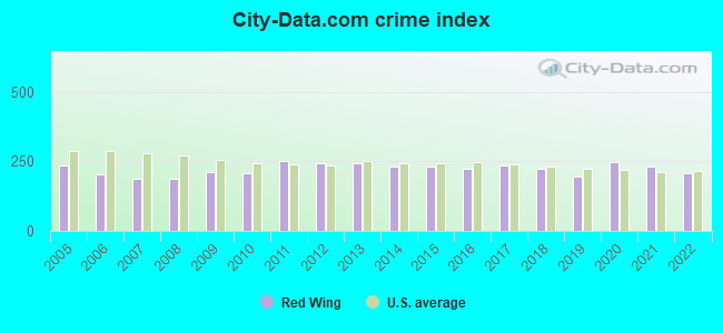
| City-Data.com crime index | 210.9 | 208.2 | 250.7 | 244.2 | 243.6 | 232.7 | 231.8 | 222.9 | 234.4 | 222.9 | 195.6 | 246.2 | 232.6 | 206.9 |
The City-Data.com crime index weighs serious crimes and violent crimes more heavily. Higher means more crime, U.S. average is 246.1. It adjusts for the number of visitors and daily workers commuting into cities.
Crime rate in Red Wing detailed stats: murders, rapes, robberies, assaults, burglaries, thefts, arson
Full-time law enforcement employees in 2021, including police officers: 30 (26 officers - 22 male; 4 female).
| Officers per 1,000 residents here: | 1.58 |
| Minnesota average: | 1.76 |
 Recent articles from our blog. Our writers, many of them Ph.D. graduates or candidates, create easy-to-read articles on a wide variety of topics.

 | Commute to the Twin City area from red wing (28 replies) |
| Move to Red Wing (6 replies) |
| In desperate need of a handyman in the Red Wing area! (7 replies) |
| Need your help moving for work to Wanamingo, MN (7 replies) |
| Potential Visit to Minnesota - crime concern? (34 replies) |
| Anyone live in Red Wing? Wondering about closeness to Prairie Island... (5 replies) |
Latest news from Red Wing, MN collected exclusively by city-data.com from local newspapers, TV, and radio stations
Ancestries: German (33.5%), Norwegian (9.0%), American (4.6%), Irish (3.9%), English (3.7%), Swedish (3.0%).
Current Local Time: CST time zone
Elevation: 750 feet
Land area: 35.4 square miles.
Population density: 471 people per square mile (low).
448 residents are foreign born (1.9% Latin America).
| This city: | 2.7% |
| Minnesota: | 8.5% |
Median real estate property taxes paid for housing units with mortgages in 2022: $2,425 (1.0%)
Median real estate property taxes paid for housing units with no mortgage in 2022: $2,773 (1.2%)
Nearest city with pop. 50,000+: Eagan, MN  (34.4 miles , pop. 63,557).
Nearest city with pop. 200,000+: St. Paul, MN (38.2 miles , pop. 287,151).
Nearest city with pop. 1,000,000+: Chicago, IL (309.9 miles , pop. 2,896,016).
Nearest cities:
), ), ), ), ), ), Latitude: 44.57 N, Longitude: 92.56 W
Daytime population change due to commuting: +4,421 (+26.5%)
Workers who live and work in this city: 6,069 (79.0%)
Area code: 651

Red Wing tourist attractions:
Red Wing, Minnesota accommodation & food services, waste management - Economy and Business Data
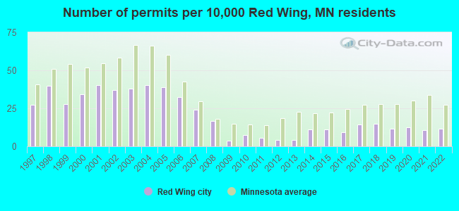
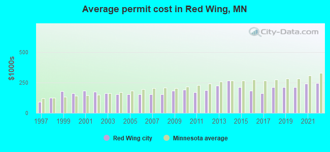
Single-family new house construction building permits:
- 2022: 19 buildings, average cost: $245,300
- 2021: 17 buildings, average cost: $242,900
- 2020: 20 buildings, average cost: $213,900
- 2019: 19 buildings, average cost: $211,900
- 2018: 24 buildings, average cost: $215,400
- 2017: 23 buildings, average cost: $161,700
- 2016: 15 buildings, average cost: $181,600
- 2015: 18 buildings, average cost: $215,300
- 2014: 18 buildings, average cost: $267,500
- 2013: 7 buildings, average cost: $223,600
- 2012: 7 buildings, average cost: $187,200
- 2011: 9 buildings, average cost: $171,000
- 2010: 12 buildings, average cost: $190,800
- 2009: 6 buildings, average cost: $182,300
- 2008: 27 buildings, average cost: $155,900
- 2007: 39 buildings, average cost: $155,900
- 2006: 52 buildings, average cost: $155,900
- 2005: 63 buildings, average cost: $156,000
- 2004: 65 buildings, average cost: $155,300
- 2003: 61 buildings, average cost: $162,400
- 2002: 60 buildings, average cost: $176,200
- 2001: 65 buildings, average cost: $182,700
- 2000: 55 buildings, average cost: $162,900
- 1999: 45 buildings, average cost: $178,500
- 1998: 64 buildings, average cost: $125,200
- 1997: 44 buildings, average cost: $89,800
| Here: | 2.6% |
| Minnesota: | 2.6% |
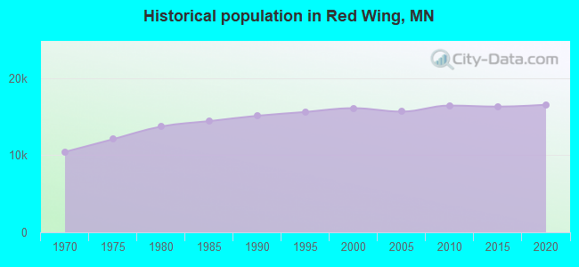
Population change in the 1990s: +891 (+5.9%).
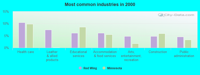
- Health care (10.4%)
- Leather & allied products (7.4%)
- Educational services (6.1%)
- Accommodation & food services (6.1%)
- Arts, entertainment, recreation (4.8%)
- Construction (4.7%)
- Public administration (4.5%)
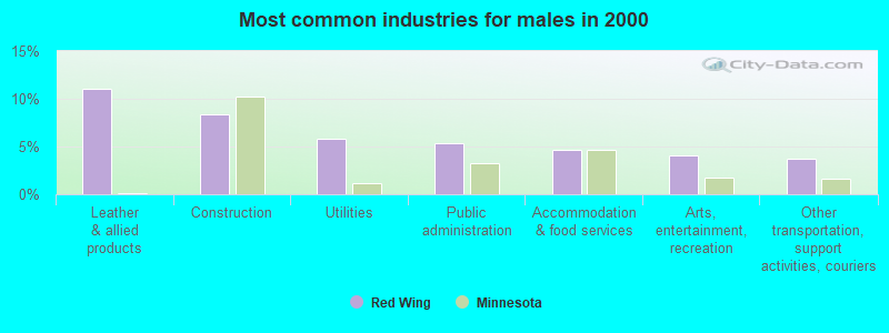
- Leather & allied products (11.1%)
- Construction (8.4%)
- Utilities (5.8%)
- Public administration (5.4%)
- Accommodation & food services (4.6%)
- Arts, entertainment, recreation (4.0%)
- Other transportation, support activities, couriers (3.7%)
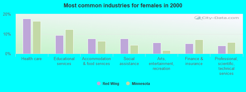
- Health care (17.7%)
- Educational services (9.3%)
- Accommodation & food services (7.7%)
- Social assistance (7.6%)
- Arts, entertainment, recreation (5.6%)
- Finance & insurance (5.1%)
- Professional, scientific, technical services (4.0%)

- Other production occupations, including supervisors (6.6%)
- Other office and administrative support workers, including supervisors (3.2%)
- Other management occupations, except farmers and farm managers (3.1%)
- Building and grounds cleaning and maintenance occupations (3.1%)
- Driver/sales workers and truck drivers (3.1%)
- Other sales and related occupations, including supervisors (3.1%)
- Retail sales workers, except cashiers (3.0%)
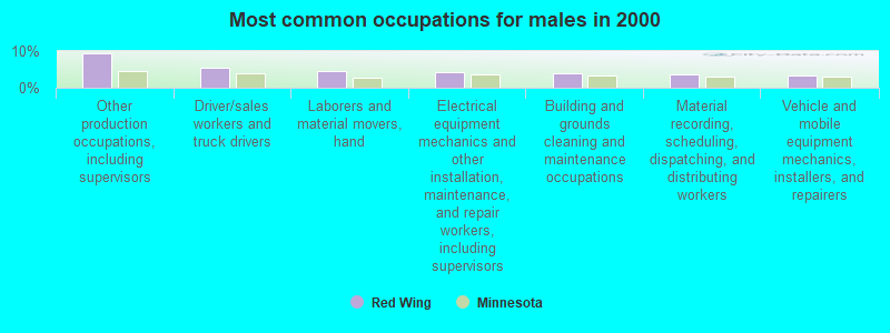
- Other production occupations, including supervisors (9.3%)
- Driver/sales workers and truck drivers (5.3%)
- Laborers and material movers, hand (4.4%)
- Electrical equipment mechanics and other installation, maintenance, and repair workers, including supervisors (4.3%)
- Building and grounds cleaning and maintenance occupations (4.1%)
- Material recording, scheduling, dispatching, and distributing workers (3.6%)
- Vehicle and mobile equipment mechanics, installers, and repairers (3.4%)

- Other office and administrative support workers, including supervisors (5.6%)
- Secretaries and administrative assistants (4.8%)
- Nursing, psychiatric, and home health aides (4.8%)
- Health technologists and technicians (4.7%)
- Retail sales workers, except cashiers (4.3%)
- Child care workers (4.2%)
- Other production occupations, including supervisors (3.6%)
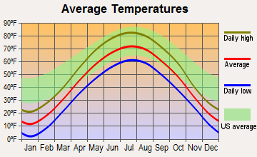
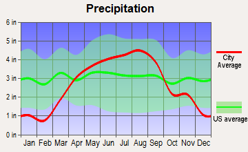
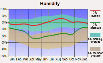
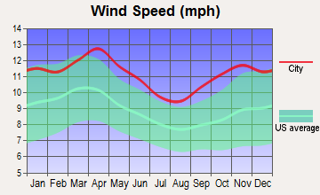
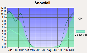
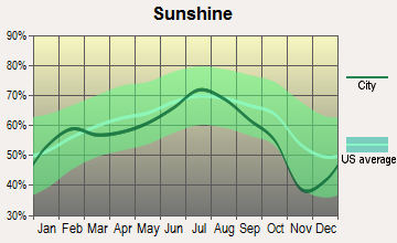
Average climate in Red Wing, Minnesota
Based on data reported by over 4,000 weather stations
|
|

(lower is better)
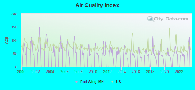
Air Quality Index (AQI) level in 2022 was 45.8. This is significantly better than average.
| City: | 45.8 |
| U.S.: | 72.6 |
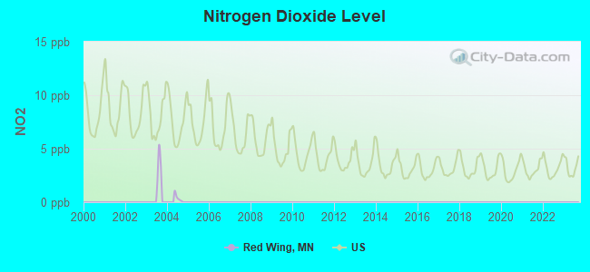
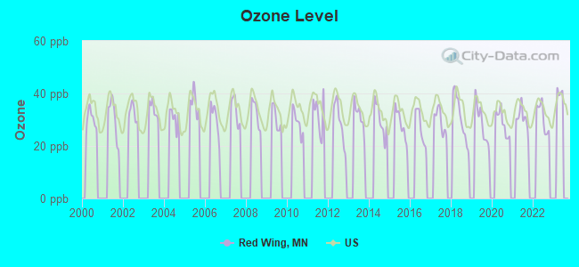
Ozone [ppb] level in 2022 was 30.9. This is about average. Closest monitor was 19.0 miles away from the city center.
| City: | 30.9 |
| U.S.: | 33.3 |
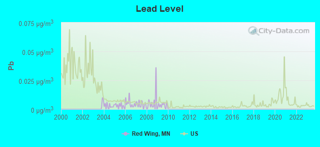
Lead (Pb) [µg/m3] level in 2009 was 0.00337. This is significantly better than average. Closest monitor was 1.2 miles away from the city center.
| City: | 0.00337 |
| U.S.: | 0.00931 |
Tornado activity:
Red Wing-area historical tornado activity is slightly above Minnesota state average. It is 31% greater than the overall U.S. average.
On 6/4/1958, a category F5 (max. wind speeds 261-318 mph) tornado 25.8 miles away from the Red Wing city center killed 21 people and injured 74 people and caused between $5,000,000 and $50,000,000 in damages.
On 7/27/1987, a category F3 (max. wind speeds 158-206 mph) tornado 7.8 miles away from the city center caused between $500,000 and $5,000,000 in damages.
Earthquake activity:
Red Wing-area historical earthquake activity is significantly above Minnesota state average. It is 49% greater than the overall U.S. average.On 7/9/1975 at 14:54:15, a magnitude 4.6 (4.6 MB, Class: Light, Intensity: IV - V) earthquake occurred 186.1 miles away from the city center
On 6/5/1993 at 01:24:53, a magnitude 4.1 (4.1 LG, Depth: 6.2 mi) earthquake occurred 197.5 miles away from Red Wing center
On 3/4/1983 at 06:32:18, a magnitude 4.6 (4.4 MB, 4.6 LG, 4.4 ML) earthquake occurred 339.2 miles away from the city center
On 6/28/2004 at 06:10:52, a magnitude 4.2 (4.2 MW, Depth: 6.2 mi) earthquake occurred 283.6 miles away from the city center
On 4/18/2008 at 09:36:59, a magnitude 5.4 (5.1 MB, 4.8 MS, 5.4 MW, 5.2 MW, Class: Moderate, Intensity: VI - VII) earthquake occurred 487.1 miles away from Red Wing center
On 10/20/1995 at 15:57:18, a magnitude 3.7 (3.7 LG, Depth: 3.1 mi, Class: Light, Intensity: II - III) earthquake occurred 226.1 miles away from the city center
Magnitude types: regional Lg-wave magnitude (LG), body-wave magnitude (MB), local magnitude (ML), surface-wave magnitude (MS), moment magnitude (MW)
Natural disasters:
The number of natural disasters in Goodhue County (16) is near the US average (15).Major Disasters (Presidential) Declared: 12
Emergencies Declared: 2
Causes of natural disasters: Floods: 12, Storms: 8, Tornadoes: 4, Winds: 2, Hurricane: 1, Ice Storm: 1, Winter Storm: 1, Other: 1 (Note: some incidents may be assigned to more than one category).
Hospitals in Red Wing:
- MAYO CLINIC HEALTH SYSTEM IN RED WING (Voluntary non-profit - Private, provides emergency services, 701 HEWITT BOULEVARD, PO BOX 95)
- RED WING REGIONAL HOSPICE (1407 WEST FOURTH STREET, BOX 134)
- REM RIVER BLUFFS (PARK HEIGHTS) (2606 MALMQUIST AVENUE)
- VASA CHILDRENS HOME (5225 W HWY 61)
Nursing Homes in Red Wing:
- HAVEN HOMES OF RED WING (213 PIONEER RD)
- RED WING HEALTH CENTER (1412 WEST FOURTH STREET)
- RED WING NURS HOME (1400 W 4TH ST)
- SEMINARY HOME (906 COLLEGE AVENUE)
- ST BRIGID'S AT HI-PARK (213 PIONEER ROAD)
Dialysis Facilities in Red Wing:
Home Health Centers in Red Wing:
Airports and heliports located in Red Wing:
- Red Wing Regional Airport (RGK) (Runways: 1, Air Taxi Ops: 220, Itinerant Ops: 7,430, Local Ops: 5,700, Military Ops: 700)
- Fairview Red Wing Medical Center Heliport (97MN)
Nuclear power plants:
- Prairie Island 1. Westinghouse Electric Corp.Fluor. Westinghouse Electric Corp.Northern States Power Co.Pressurized Water Reactor (PWR). Net Output: 503 MWe. Operable. Initial criticality: 12/1973. Commercial start: 12/1973..
- Prairie Island 2. Westinghouse Electric Corp.Fluor. Westinghouse Electric Corp.Northern States Power Co.Pressurized Water Reactor (PWR). Net Output: 500 MWe. Operable. Initial criticality: 12/1974. Commercial start: 12/1974..
Colleges/universities with over 2000 students nearest to Red Wing:
- University of Wisconsin-River Falls (about 21 miles; River Falls, WI; Full-time enrollment: 5,868)
- Dakota County Technical College (about 29 miles; Rosemount, MN; FT enrollment: 2,478)
- Inver Hills Community College (about 31 miles; Inver Grove Heights, MN; FT enrollment: 4,049)
- St Olaf College (about 32 miles; Northfield, MN; FT enrollment: 3,141)
- Metropolitan State University (about 37 miles; Saint Paul, MN; FT enrollment: 6,159)
- Saint Paul College (about 38 miles; Saint Paul, MN; FT enrollment: 4,778)
- University of Wisconsin-Stout (about 39 miles; Menomonie, WI; FT enrollment: 8,120)
Public high schools in Red Wing:
- MCF-REDWING, MAGINNIS HIGH SCHOOL (Location: 1079 HWY 292, Grades: 8-12)
- RED WING SENIOR HIGH (Location: 2451 EAGLE RIDGE DR, Grades: 8-12)
- REACH PROGRAMS (Location: 601 BUCHANAN ST, Grades: PK-12)
- TOWER VIEW ALTERNATIVE HIGH SCHOOL (Location: 154 TOWER VIEW DRIVE, Grades: 10-12)
- RED WING HIGH SCHOOL INDEPENDENT ST (Location: 2451 EAGLE RIDGE DR, Grades: 9-12)
- PATHWAYS PROGRAM AT RED WING HIGH S (Location: 2451 EAGLE RIDGE BLVD, Grades: 8-9)
Public elementary/middle schools in Red Wing:
- BURNSIDE ELEMENTARY. (Location: 5001 LEARNING LN, Grades: 2-4)
- SUNNYSIDE ELEMENTARY (Location: 1669 SOUTHWOOD AVE, Grades: KG-2)
- TWIN BLUFF MIDDLE SCHOOL (Location: 2120 TWIN BLUFF RD, Grades: 5-7)
- PATHWAYS PROGRAM (Location: 2120 TWIN BLUFF ROAD, Grades: 6-7)
Private elementary/middle school in Red Wing:
- ST JOHNS LUTHERAN SCHOOL (Students: 65, Location: 421 EAST AVE, Grades: KG-8)
User-submitted facts and corrections:
- In 2001 Red Wing was chosen as #1 town in Minnesota. added by Sheridan
Points of interest:
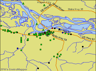
Notable locations in Red Wing: Red Wing Country Club (A), Red Wing (B), Riverfront Centre (C), Mississippi National Golf Links (D), Goodhue County Courthouse (E), Milwaukee Depot (F), Red Wing Shoe Museum (G), Red Wing Library (H), Red Wing City Hall (I), Goodhue County Historical Society Museum (J), Goodhue County Sheriffs Office (K), Red Wing Police Department (L), Red Wing Fire Department (M). Display/hide their locations on the map
Shopping Center: Red Wing Mall (1). Display/hide its location on the map
Churches in Red Wing include: Messiah Episcopal Church (A), Our Redeemer Lutheran Church (B), Church of Christ (C), Assembly of God Church (D), Open Door Alliance Church (E), Berean Baptist Church (F), New Life United Pentecostal Church (G), Apostolic Gospel Church (H), Jehovahs Witnesses Congregation (I). Display/hide their locations on the map
Cemeteries: Oakwood Cemetery (1), Burnside Cemetery (2), Calvary Cemetery (3), Saint Johns Cemetery (4), Goodhue County Poor Farm Cemetery (5), Mount Carmel Cemetery (6). Display/hide their locations on the map
Lakes, reservoirs, and swamps: Birch Lake (A), Pool 3 (B), Wildcat Lake (C), Upper Round Lake (D), Sturgeon Lake (E), Spring Creek Lake (F), Round Lake (G), Pickerel Slough (H). Display/hide their locations on the map
Streams, rivers, and creeks: Trout Brook (A), Crooked Creek (B), Catfish Slu (C), Cannon River (D), Spring Creek (E), Hay Creek (F), Vermillion River (G), Vermillion Slough (H). Display/hide their locations on the map
Parks in Red Wing include: Sunnyside/Roosevelt Park (1), Soldiers Memorial Park (2), South Park (3), Red Wing Region Historical Marker (4), Barn Bluff Historical Marker (5), William Colvill Historical Marker (6), Minnesota State Training School Entrance Walls (7), Red Wing Wayside Park (8), Espen Island State Wildlife Management Area (9). Display/hide their locations on the map
Tourist attractions: Goodhue County History Center (Museums; 1166 Oak Street) (1), Red Wing Pottery Museum (Cultural Attractions- Events- & Facilities; Pottery Place Mall) (2). Display/hide their approximate locations on the map
Hotels: St James Hotel (406 Main Street Suite A) (1), St. James Hotel (406 Main Street) (2), Golden Lantern Inn (721 East Ave.) (3), Americinn of Red Wing (1819 Old West Main Street) (4), Best Western Quiet House (752 Withers Harbor Drive) (5), Parkway Motel (3425 Highway 61 West) (6), Red Wing-Days Inn (955 E 7th St) (7), Rodeway Inn (235 Withers Harbor Drive) (8), St James Hotel Red Wing (406 Main Street Suite A) (9). Display/hide their approximate locations on the map
Court: Goodhue County Government Offices - Goodhue County Justice Center- Court Administra (454 West 6th) (1). Display/hide its approximate location on the map
Birthplace of: Ned Locke - Television personality, Patrick Flueger - Actor, Nick Schommer - Football player, Cully Lidberg - Football player.
Drinking water stations with addresses in Red Wing and their reported violations in the past:
YMCA CAMP PEPIN - NEW WELL (Address: 434 MAIN STREET , Serves WI, Population served: 125, Groundwater):Past health violations:
- MCL, Monthly (TCR) - In JUL-2008, Contaminant: Coliform. Follow-up actions: St Public Notif requested (JUL-08-2008), St Violation/Reminder Notice (JUL-08-2008), St Public Notif received (JUL-09-2008), St Compliance achieved (JUL-15-2008)
Drinking water stations with addresses in Red Wing that have no violations reported:
| This city: | 2.3 people |
| Minnesota: | 2.5 people |
| This city: | 61.7% |
| Whole state: | 64.6% |
| This city: | 7.4% |
| Whole state: | 6.9% |
Likely homosexual households (counted as self-reported same-sex unmarried-partner households)
- Lesbian couples: 0.3% of all households
- Gay men: 0.2% of all households
People in group quarters in Red Wing in 2010:
- 236 people in nursing facilities/skilled-nursing facilities
- 102 people in correctional facilities intended for juveniles
- 67 people in group homes intended for adults
- 55 people in local jails and other municipal confinement facilities
- 43 people in workers' group living quarters and job corps centers
- 17 people in group homes for juveniles (non-correctional)
- 14 people in emergency and transitional shelters (with sleeping facilities) for people experiencing homelessness
- 4 people in residential treatment centers for adults
People in group quarters in Red Wing in 2000:
- 294 people in nursing homes
- 181 people in unknown juvenile institutions
- 107 people in homes for the mentally retarded
- 51 people in local jails and other confinement facilities (including police lockups)
- 30 people in other noninstitutional group quarters
- 29 people in hospitals/wards and hospices for chronically ill
- 29 people in other hospitals or wards for chronically ill
Banks with branches in Red Wing (2011 data):
- White Rock Bank: Red Wing Downtown Branch at 203 East Avenue, branch established on 2003/05/14; North Service Drive Branch at 3141 North Service Drive, branch established on 2003/12/23. Info updated 2006/11/03: Bank assets: $140.5 mil, Deposits: $122.0 mil, headquarters in Cannon Falls, MN, positive income, Agricultural Specialization, 7 total offices, Holding Company: 215 Holding Co.
- Wells Fargo Bank, National Association: Red Wing Branch at 401 Plum Street, branch established on 2001/01/02. Info updated 2011/04/05: Bank assets: $1,161,490.0 mil, Deposits: $905,653.0 mil, headquarters in Sioux Falls, SD, positive income, 6395 total offices, Holding Company: Wells Fargo & Company
- Alliance Bank: Red Wing Branch at 840 Technology Drive, branch established on 2008/01/07. Info updated 2007/03/09: Bank assets: $594.8 mil, Deposits: $509.0 mil, headquarters in Lake City, MN, positive income, Commercial Lending Specialization, 15 total offices, Holding Company: Alliance Financial Services, Inc.
- Citizens Community Federal: Red Wing Branch at 295 Tyler Road S, branch established on 2008/03/03. Info updated 2011/07/21: Bank assets: $530.8 mil, Deposits: $444.7 mil, headquarters in Eau Claire, WI, positive income, Mortgage Lending Specialization, 28 total offices
- Merchants Bank, National Association: Redwing Branch at 2835 South Service Drive, branch established on 2002/02/14. Info updated 2012/01/06: Bank assets: $1,241.1 mil, Deposits: $1,007.4 mil, headquarters in Winona, MN, positive income, Commercial Lending Specialization, 19 total offices, Holding Company: Merchants Financial Group, Inc.
- Minnesota First Credit and Savings, Incorporated: Red Wing at 144 Tyler Road North, branch established on 2009/06/01. Info updated 2009/12/23: Bank assets: $29.6 mil, Deposits: $24.5 mil, headquarters in Rochester, MN, positive income, Mortgage Lending Specialization, 4 total offices
- Associated Bank, National Association: Red Wing Branch at 222 Bush Street, branch established on 1874/01/01. Info updated 2008/09/12: Bank assets: $21,715.0 mil, Deposits: $15,244.4 mil, headquarters in Green Bay, WI, positive income, Commercial Lending Specialization, 282 total offices, Holding Company: Associated Banc-Corp
- The First State Bank of Red Wing: The First State Bank Of Red Wing at 3209 South Service Drive, branch established on 1915/10/14. Info updated 2011/03/08: Bank assets: $71.2 mil, Deposits: $63.0 mil, local headquarters, positive income, 3 total offices, Holding Company: Noble Bank Holding Company, Inc.
For population 15 years and over in Red Wing:
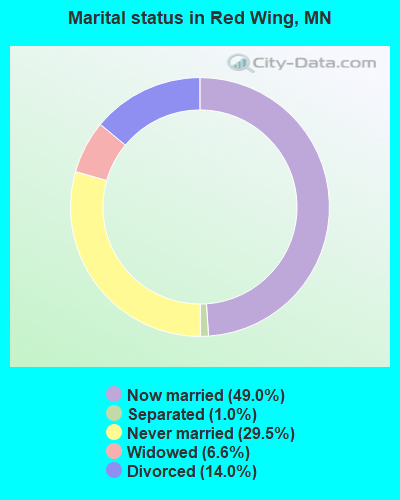
- Never married: 29.5%
- Now married: 49.0%
- Separated: 1.0%
- Widowed: 6.6%
- Divorced: 14.0%
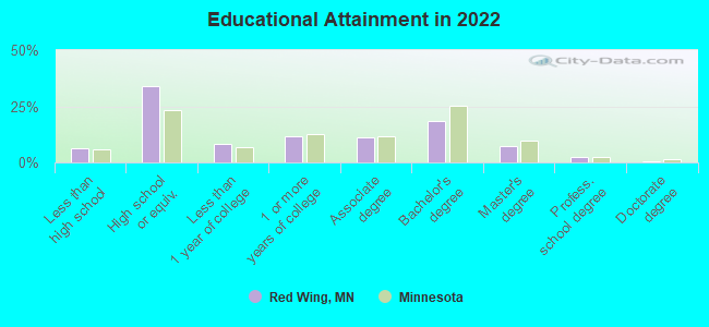
For population 25 years and over in Red Wing:
- High school or higher: 92.7%
- Bachelor's degree or higher: 27.4%
- Graduate or professional degree: 9.5%
- Unemployed: 3.5%
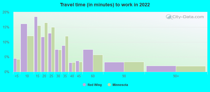
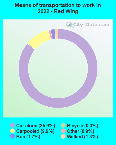
- Mean travel time to work (commute): 18.6 minutes
| Here: | 9.9 |
| Minnesota average: | 10.9 |


Graphs represent county-level data. Detailed 2008 Election Results
Neighborhoods in Red Wing:
(Red Wing, Minnesota Neighborhood Map)Religion statistics for Red Wing, MN (based on Goodhue County data)
| Religion | Adherents | Congregations |
|---|---|---|
| Mainline Protestant | 18,320 | 36 |
| Evangelical Protestant | 5,901 | 40 |
| Catholic | 5,805 | 8 |
| Other | 489 | 3 |
| None | 15,668 | - |
Food Environment Statistics:
| Here: | 2.62 / 10,000 pop. |
| Minnesota: | 1.83 / 10,000 pop. |
| Goodhue County: | 0.22 / 10,000 pop. |
| Minnesota: | 0.13 / 10,000 pop. |
| This county: | 5.69 / 10,000 pop. |
| Minnesota: | 3.90 / 10,000 pop. |
| Here: | 7.43 / 10,000 pop. |
| State: | 6.98 / 10,000 pop. |
| This county: | 6.7% |
| Minnesota: | 6.5% |
| Here: | 28.0% |
| Minnesota: | 25.9% |
| Here: | 13.3% |
| Minnesota: | 13.0% |
Health and Nutrition:
| This city: | 48.8% |
| Minnesota: | 50.6% |
| Here: | 44.8% |
| State: | 48.4% |
| Red Wing: | 28.9 |
| Minnesota: | 28.5 |
| Here: | 22.8% |
| Minnesota: | 21.0% |
| Red Wing: | 11.1% |
| Minnesota: | 9.8% |
| Here: | 6.8 |
| Minnesota: | 6.8 |
| Here: | 34.6% |
| Minnesota: | 33.5% |
| Red Wing: | 54.9% |
| Minnesota: | 57.7% |
| Red Wing: | 76.8% |
| Minnesota: | 79.3% |
More about Health and Nutrition of Red Wing, MN Residents
| Local government employment and payroll (March 2022) | |||||
| Function | Full-time employees | Monthly full-time payroll | Average yearly full-time wage | Part-time employees | Monthly part-time payroll |
|---|---|---|---|---|---|
| Firefighters | 28 | $228,115 | $97,764 | 29 | $12,441 |
| Police Protection - Officers | 27 | $188,362 | $83,716 | 0 | $0 |
| Solid Waste Management | 25 | $130,854 | $62,810 | 0 | $0 |
| Streets and Highways | 19 | $119,086 | $75,212 | 0 | $0 |
| Financial Administration | 17 | $133,607 | $94,311 | 8 | $8,440 |
| Other Government Administration | 14 | $101,197 | $86,740 | 11 | $8,151 |
| Other and Unallocable | 13 | $85,389 | $78,821 | 0 | $0 |
| Parks and Recreation | 12 | $72,563 | $72,563 | 10 | $465 |
| Sewerage | 10 | $62,218 | $74,662 | 0 | $0 |
| Water Supply | 8 | $48,005 | $72,008 | 0 | $0 |
| Local Libraries | 6 | $40,760 | $81,520 | 8 | $16,396 |
| Police - Other | 5 | $25,121 | $60,290 | 6 | $335 |
| Fire - Other | 1 | $3,952 | $47,424 | 0 | $0 |
| Totals for Government | 185 | $1,239,229 | $80,382 | 72 | $46,228 |
Red Wing government finances - Expenditure in 2021 (per resident):
- Construction - Regular Highways: $5,521,000 ($331.15)
- Current Operations - Solid Waste Management: $7,192,000 ($431.38)
Health - Other: $5,792,000 ($347.41)
Police Protection: $5,310,000 ($318.50)
Sewerage: $4,686,000 ($281.07)
Regular Highways: $4,108,000 ($246.40)
General - Other: $3,999,000 ($239.86)
Water Utilities: $3,079,000 ($184.68)
Local Fire Protection: $2,920,000 ($175.14)
Parks and Recreation: $2,917,000 ($174.96)
Libraries: $1,308,000 ($78.45)
Financial Administration: $711,000 ($42.65)
Miscellaneous Commercial Activities - Other: $358,000 ($21.47)
Central Staff Services: $258,000 ($15.48)
Air Transportation: $250,000 ($15.00)
Transit Utilities: $31,000 ($1.86)
- General - Interest on Debt: $1,459,000 ($87.51)
- Other Capital Outlay - Solid Waste Management: $2,629,000 ($157.69)
Parks and Recreation: $1,749,000 ($104.91)
Sewerage: $759,000 ($45.53)
Regular Highways: $498,000 ($29.87)
Water Utilities: $322,000 ($19.31)
Police Protection: $270,000 ($16.19)
General - Other: $258,000 ($15.48)
Health - Other: $105,000 ($6.30)
Air Transportation: $18,000 ($1.08)
- Water Utilities - Interest on Debt: $110,000 ($6.60)
Red Wing government finances - Revenue in 2021 (per resident):
- Charges - Sewerage: $5,154,000 ($309.14)
Hospital Public: $4,680,000 ($280.71)
Solid Waste Management: $4,632,000 ($277.83)
Regular Highways: $1,987,000 ($119.18)
Parks and Recreation: $998,000 ($59.86)
Other: $598,000 ($35.87)
Miscellaneous Commercial Activities: $296,000 ($17.75)
Air Transportation: $80,000 ($4.80)
- Federal Intergovernmental - Health and Hospitals: $1,323,000 ($79.35)
Other: $702,000 ($42.11)
- Local Intergovernmental - Other: $357,000 ($21.41)
- Miscellaneous - Special Assessments: $867,000 ($52.00)
General Revenue - Other: $851,000 ($51.04)
Interest Earnings: $617,000 ($37.01)
Fines and Forfeits: $45,000 ($2.70)
- Revenue - Water Utilities: $4,180,000 ($250.72)
- State Intergovernmental - Other: $2,203,000 ($132.14)
Highways: $1,294,000 ($77.62)
General Local Government Support: $799,000 ($47.92)
Health and Hospitals: $88,000 ($5.28)
- Tax - Property: $23,765,000 ($1425.44)
Other License: $279,000 ($16.73)
Public Utilities Sales: $241,000 ($14.46)
Other Selective Sales: $188,000 ($11.28)
Red Wing government finances - Debt in 2021 (per resident):
- Long Term Debt - Beginning Outstanding - Unspecified Public Purpose: $48,386,000 ($2902.23)
Outstanding Unspecified Public Purpose: $42,590,000 ($2554.58)
Beginning Outstanding - Public Debt for Private Purpose: $15,597,000 ($935.52)
Outstanding Nonguaranteed - Industrial Revenue: $14,465,000 ($867.62)
Retired Unspecified Public Purpose: $5,796,000 ($347.65)
Retired Nonguaranteed - Public Debt for Private Purpose: $1,132,000 ($67.90)
Red Wing government finances - Cash and Securities in 2021 (per resident):
- Other Funds - Cash and Securities: $466,000 ($27.95)
- Sinking Funds - Cash and Securities: $14,465,000 ($867.62)
| Businesses in Red Wing, MN | ||||
| Name | Count | Name | Count | |
|---|---|---|---|---|
| Ace Hardware | 1 | McDonald's | 1 | |
| AmericInn | 1 | Menards | 1 | |
| Applebee's | 1 | New Balance | 1 | |
| Arby's | 1 | Nike | 3 | |
| Best Western | 1 | OfficeMax | 1 | |
| Caribou Coffee | 1 | Pizza Hut | 1 | |
| Chevrolet | 1 | RadioShack | 1 | |
| Curves | 1 | Rodeway Inn | 1 | |
| Dairy Queen | 1 | Sears | 1 | |
| Days Inn | 1 | Slumberland | 1 | |
| Domino's Pizza | 1 | Subway | 2 | |
| Famous Footwear | 1 | Super 8 | 1 | |
| FedEx | 1 | T-Mobile | 3 | |
| Ford | 1 | Target | 1 | |
| H&R Block | 1 | U-Haul | 1 | |
| JCPenney | 1 | UPS | 4 | |
| La-Z-Boy | 1 | Vans | 1 | |
| Lane Furniture | 1 | Walgreens | 2 | |
| MasterBrand Cabinets | 5 | Walmart | 1 | |
| Maurices | 1 | YMCA | 1 | |
Strongest AM radio stations in Red Wing:
- KCUE (1250 AM; 1 kW; RED WING, MN; Owner: SORENSON BROADCASTING CORP.)
- WCTS (1030 AM; 50 kW; MAPLEWOOD, MN; Owner: CNTL. BAPT. THEO/AL SEMI MINNEAPOLIS)
- KFAN (1130 AM; 50 kW; MINNEAPOLIS, MN; Owner: AMFM RADIO LICENSES, L.L.C.)
- KSTP (1500 AM; 50 kW; ST. PAUL, MN; Owner: KSTP-AM, LLC (DELAWARE))
- KTIS (900 AM; 25 kW; MINNEAPOLIS, MN; Owner: NORTHWESTERN COLLEGE)
- WCCO (830 AM; 50 kW; MINNEAPOLIS, MN; Owner: INFINITY MEDIA CORPORATION)
- WDGY (630 AM; 8 kW; HUDSON, WI; Owner: 630 RADIO, INCORPORATED)
- WMEQ (880 AM; 10 kW; MENOMONIE, WI; Owner: CAPSTAR TX LIMITED PARTNERSHIP)
- WMNN (1330 AM; 10 kW; MINNEAPOLIS, MN; Owner: MINNESOTA PUBLIC RADIO.)
- KOLM (1520 AM; 10 kW; ROCHESTER, MN; Owner: OLMSTED COUNTY BROADCASTING COMPANY)
- KKMS (980 AM; 5 kW; RICHFIELD, MN)
- WEBC (560 AM; 50 kW; DULUTH, MN)
- KUOM (770 AM; daytime; 5 kW; MINNEAPOLIS, MN)
Strongest FM radio stations in Red Wing:
- K297AF (107.3 FM; RED WING, MN; Owner: KRCH OF MINNESOTA, INC.)
- KWNG (105.9 FM; RED WING, MN; Owner: SORENSON BROADCASTING CORPORATION)
- WCAL (89.3 FM; NORTHFIELD, MN; Owner: ST. OLAF COLLEGE)
- WXPT (104.1 FM; ST. LOUIS PARK, MN; Owner: THE AUDIO HOUSE, INC.)
- KNOW-FM (91.1 FM; MINNEAPOLIS-ST. PAUL, MN; Owner: MINNESOTA PUBLIC RADIO)
- WLTE (102.9 FM; MINNEAPOLIS, MN; Owner: INFINITY MEDIA CORPORATION)
- KNXR (97.5 FM; ROCHESTER, MN; Owner: UNITED AUDIO CORPORATION)
- KSTP-FM (94.5 FM; ST. PAUL, MN; Owner: KSTP-FM, LLC, A DELAWARE LLC)
- KLSE-FM (91.7 FM; ROCHESTER, MN; Owner: MINNESOTA PUBLIC RADIO)
- KLCH (94.9 FM; LAKE CITY, MN; Owner: WAITT RADIO, INC.)
- KEEY-FM (102.1 FM; ST. PAUL, MN; Owner: AMFM RADIO LICENSES, L.L.C.)
- KTIS-FM (98.5 FM; MINNEAPOLIS, MN; Owner: NORTHWESTERN COLLEGE)
- KZSE (90.7 FM; ROCHESTER, MN; Owner: MINNESOTA PUBLIC RADIO)
- KDWB-FM (101.3 FM; RICHFIELD, MN; Owner: AMFM RADIO LICENSES, L.L.C.)
- KQRS-FM (92.5 FM; GOLDEN VALLEY, MN; Owner: KQRS, Inc.)
- KSJN (99.5 FM; MINNEAPOLIS, MN; Owner: MINNESOTA PUBLIC RADIO)
- KXXR (93.7 FM; MINNEAPOLIS, MN; Owner: KQRS, INC.)
- KMFX-FM (102.5 FM; LAKE CITY, MN; Owner: CLEAR CHANNEL BROADCASTING LICENSES, INC.)
- WGVX (105.1 FM; LAKEVILLE, MN; Owner: KQRS, INC.)
- WEVR-FM (106.3 FM; RIVER FALLS, WI; Owner: HANTEN BROADCASTING COMPANY, INC.)
TV broadcast stations around Red Wing:
- KMSP-TV (Channel 9; MINNEAPOLIS, MN; Owner: FOX TELEVISION STATIONS, INC.)
- KARE (Channel 11; MINNEAPOLIS, MN; Owner: MULTIMEDIA HOLDINGS CORPORATION)
- KSTP-TV (Channel 5; ST. PAUL, MN; Owner: HUBBARD BROADCASTING, INC.)
- KTCA-TV (Channel 2; ST. PAUL, MN; Owner: TWIN CITIES PUBLIC TELEVISION, INC.)
- KXLT-TV (Channel 47; ROCHESTER, MN; Owner: SHOCKLEY BROADCASTING, LLC)
- WCCO-TV (Channel 4; MINNEAPOLIS, MN; Owner: CBS BROADCASTING INC.)
- KTCI-TV (Channel 17; ST. PAUL, MN; Owner: TWIN CITIES PUBLIC TELEVISION, INC.)
- KSTC-TV (Channel 45; MINNEAPOLIS, MN; Owner: HUBBARD BROADCASTING, INC.)
- KMWB (Channel 23; MINNEAPOLIS, MN; Owner: KLGT LICENSEE, LLC)
- WFTC (Channel 29; MINNEAPOLIS, MN; Owner: FOX TELEVISION STATIONS, INC.)
- WHWC-TV (Channel 28; MENOMONIE, WI; Owner: STATE OF WISCONSIN - EDUCATIONAL COMMUNICATIONS BOARD)
- National Bridge Inventory (NBI) Statistics
- 64Number of bridges
- 860ft / 262mTotal length
- $996,001,000Total costs
- 284,454Total average daily traffic
- 13,880Total average daily truck traffic
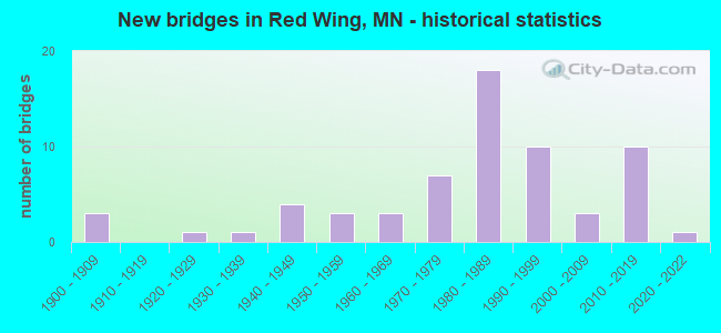
- New bridges - historical statistics
- 31900-1909
- 11920-1929
- 11930-1939
- 41940-1949
- 31950-1959
- 31960-1969
- 71970-1979
- 181980-1989
- 101990-1999
- 32000-2009
- 102010-2019
- 12020-2022
FCC Registered Antenna Towers: 103 (See the full list of FCC Registered Antenna Towers)
FCC Registered Commercial Land Mobile Towers: 1 (See the full list of FCC Registered Commercial Land Mobile Towers in Red Wing, MN)
FCC Registered Private Land Mobile Towers: 3 (See the full list of FCC Registered Private Land Mobile Towers)
FCC Registered Broadcast Land Mobile Towers: 24 (See the full list of FCC Registered Broadcast Land Mobile Towers)
FCC Registered Microwave Towers: 27 (See the full list of FCC Registered Microwave Towers in this town)
FCC Registered Paging Towers: 5 (See the full list of FCC Registered Paging Towers)
FCC Registered Maritime Coast & Aviation Ground Towers: 8 (See the full list of FCC Registered Maritime Coast & Aviation Ground Towers)
FCC Registered Amateur Radio Licenses: 85 (See the full list of FCC Registered Amateur Radio Licenses in Red Wing)
FAA Registered Aircraft: 22 (See the full list of FAA Registered Aircraft in Red Wing)
2002 - 2018 National Fire Incident Reporting System (NFIRS) incidents
- Fire incident types reported to NFIRS in Red Wing, MN
- 28941.2%Structure Fires
- 23233.1%Outside Fires
- 14120.1%Mobile Property/Vehicle Fires
- 395.6%Other
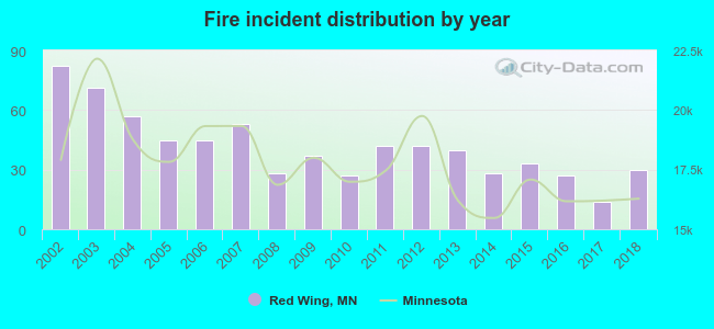 Based on the data from the years 2002 - 2018 the average number of fires per year is 41. The highest number of fires - 82 took place in 2002, and the least - 14 in 2017. The data has a dropping trend.
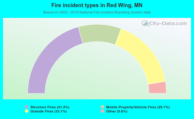 When looking into fire subcategories, the most incidents belonged to: Structure Fires (41.2%), and Outside Fires (33.1%).
Fire-safe hotels and motels in Red Wing, Minnesota:
- Best Western Rivertown Inn & Suites, 752 Withers Hbr Dr, Red Wing, Minnesota 55066 , Phone: (651) 388-1577, Fax: (651) 388-1150
- Country Inn & Suites, 4275 Hwy 61 W, Red Wing, Minnesota 55066 , Phone: (651) 388-9000, Fax: (651) 388-9009
- Red Wing Nichols Inn, 1750 Hwy 61, Red Wing, Minnesota 55066 , Phone: (651) 388-6633, Fax: (651) 388-7512
- Red Wing Americinn, 1819 Old W Main, Red Wing, Minnesota 55066 , Phone: (651) 385-9060, Fax: (651) 385-8139
- St. James Hotel, 406 Main St, Red wing, Minnesota 55066 , Phone: (651) 388-2846, Fax: (651) 388-5226
- Holiday Inn Express & Suites Red Wing MN, 1919 Old W Main St, Red wing, Minnesota 55066 , Phone: (651) 327-2225
| Most common first names in Red Wing, MN among deceased individuals | ||
| Name | Count | Lived (average) |
|---|---|---|
| John | 115 | 78.3 years |
| William | 88 | 78.6 years |
| Robert | 80 | 72.0 years |
| Helen | 79 | 80.5 years |
| Anna | 68 | 87.9 years |
| Mary | 64 | 81.0 years |
| Charles | 61 | 78.5 years |
| George | 59 | 79.7 years |
| Dorothy | 59 | 79.6 years |
| Arthur | 58 | 79.3 years |
| Most common last names in Red Wing, MN among deceased individuals | ||
| Last name | Count | Lived (average) |
|---|---|---|
| Johnson | 175 | 80.6 years |
| Anderson | 121 | 80.4 years |
| Nelson | 78 | 80.4 years |
| Olson | 76 | 81.4 years |
| Peterson | 64 | 80.3 years |
| Larson | 61 | 81.1 years |
| Swanson | 57 | 80.4 years |
| Carlson | 52 | 81.5 years |
| Miller | 46 | 81.4 years |
| Hanson | 31 | 78.8 years |
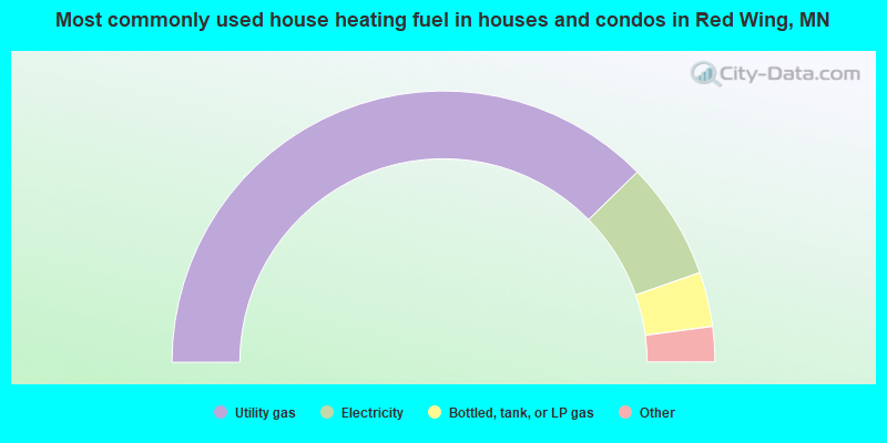
- 75.3%Utility gas
- 14.0%Electricity
- 6.5%Bottled, tank, or LP gas
- 1.9%Other fuel
- 1.2%Wood
- 1.1%No fuel used
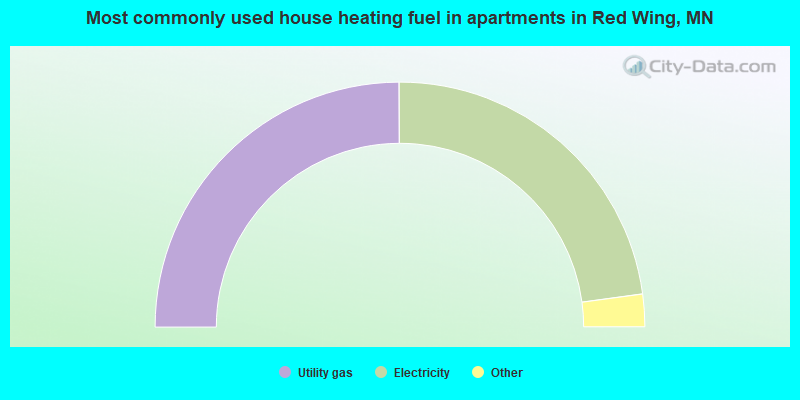
- 49.9%Utility gas
- 45.8%Electricity
- 2.7%No fuel used
- 1.0%Bottled, tank, or LP gas
- 0.5%Other fuel
Red Wing compared to Minnesota state average:
- Unemployed percentage significantly below state average.
- Black race population percentage below state average.
- Foreign-born population percentage significantly below state average.
- Length of stay since moving in significantly above state average.
- Institutionalized population percentage above state average.
Red Wing on our top lists:
- #29 on the list of "Top 101 cities with the largest percentage of people in unknown juvenile institutions (population 1,000+)"

|
|
Total of 193 patent applications in 2008-2024.