Mount Selman, Texas
Submit your own pictures of this place and show them to the world
- OSM Map
- General Map
- Google Map
- MSN Map

| Males: 2,109 | |
| Females: 2,191 |
| Median resident age: | 37.4 years |
| Texas median age: | 32.3 years |
Zip code: 75757
| Mount Selman: | $69,283 |
| TX: | $72,284 |
Estimated per capita income in 2022: $32,748 (it was $16,816 in 2000)
Mount Selman CCD income, earnings, and wages data
Estimated median house or condo value in 2022: $183,248 (it was $59,000 in 2000)
| Mount Selman: | $183,248 |
| TX: | $275,400 |
Mean prices in 2022: all housing units: $240,617; detached houses: $257,111; townhouses or other attached units: over $1,000,000; in 2-unit structures: $439,387; mobile homes: $124,284; occupied boats, rvs, vans, etc.: $26,643
Detailed information about poverty and poor residents in Mount Selman, TX


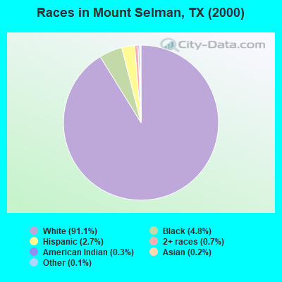
- 3,80491.1%White alone
- 2024.8%Black alone
- 1132.7%Hispanic
- 280.7%Two or more races
- 140.3%American Indian alone
- 80.2%Asian alone
- 60.1%Other race alone
Races in Mount Selman detailed stats: ancestries, foreign born residents, place of birth
 Recent articles from our blog. Our writers, many of them Ph.D. graduates or candidates, create easy-to-read articles on a wide variety of topics.
Current Local Time: CST time zone
Land area: 94.1 square miles.
Population density: 46 people per square mile (very low).

| Mount Selman CCD: | 1.3% ($759) |
| Texas: | 1.8% ($1,393) |
Nearest city with pop. 50,000+: Tyler, TX  (16.4 miles , pop. 83,650).
Nearest city with pop. 200,000+: Garland, TX (94.3 miles , pop. 215,768).
Nearest city with pop. 1,000,000+: Dallas, TX (97.7 miles , pop. 1,188,580).
Nearest cities:
), ), )Latitude: 32.10 N, Longitude: 95.33 W
Area code commonly used in this area: 903

| Here: | 4.0% |
| Texas: | 3.5% |
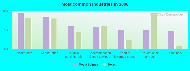
- Health care (9.5%)
- Construction (8.4%)
- Public administration (6.0%)
- Accommodation & food services (5.8%)
- Food & beverage stores (5.1%)
- Educational services (5.0%)
- Machinery (4.8%)
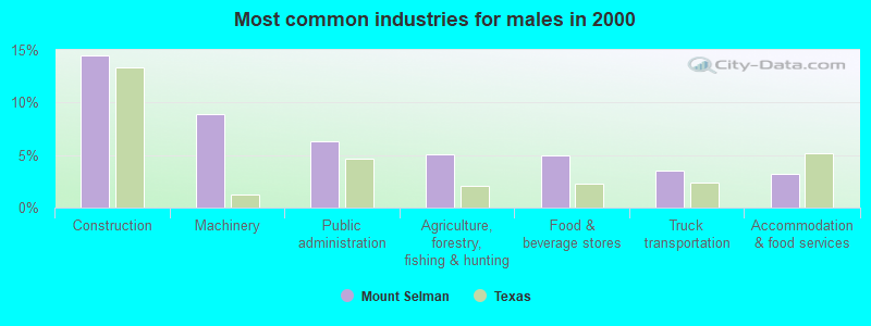
- Construction (14.5%)
- Machinery (8.9%)
- Public administration (6.3%)
- Agriculture, forestry, fishing & hunting (5.0%)
- Food & beverage stores (4.9%)
- Truck transportation (3.5%)
- Accommodation & food services (3.2%)
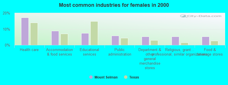
- Health care (17.1%)
- Accommodation & food services (8.8%)
- Educational services (7.4%)
- Public administration (5.8%)
- Department & other general merchandise stores (5.3%)
- Religious, grantmaking, civic, professional, similar organizations (5.3%)
- Food & beverage stores (5.2%)
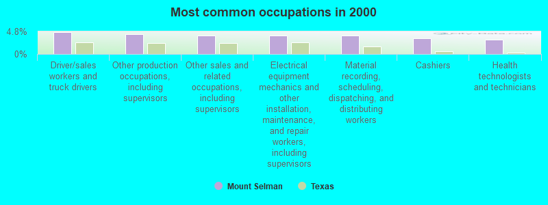
- Driver/sales workers and truck drivers (4.6%)
- Other production occupations, including supervisors (4.2%)
- Other sales and related occupations, including supervisors (4.0%)
- Electrical equipment mechanics and other installation, maintenance, and repair workers, including supervisors (3.9%)
- Material recording, scheduling, dispatching, and distributing workers (3.9%)
- Cashiers (3.4%)
- Health technologists and technicians (3.0%)
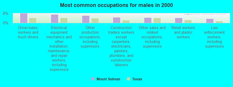
- Driver/sales workers and truck drivers (8.0%)
- Electrical equipment mechanics and other installation, maintenance, and repair workers, including supervisors (7.2%)
- Other production occupations, including supervisors (6.3%)
- Construction traders workers except carpenters, electricians, painters, plumbers, and construction laborers (4.8%)
- Other sales and related occupations, including supervisors (4.6%)
- Metal workers and plastic workers (4.3%)
- Law enforcement workers, including supervisors (3.7%)

- Health technologists and technicians (6.4%)
- Secretaries and administrative assistants (5.9%)
- Cashiers (5.9%)
- Material recording, scheduling, dispatching, and distributing workers (4.6%)
- Bookkeeping, accounting, and auditing clerks (4.5%)
- Waiters and waitresses (4.4%)
- Information and record clerks, except customer service representatives (4.4%)
Average climate in Mount Selman, Texas
Based on data reported by over 4,000 weather stations


(lower is better)
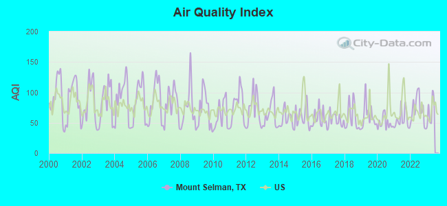
Air Quality Index (AQI) level in 2022 was 71.4. This is about average.
| City: | 71.4 |
| U.S.: | 72.6 |
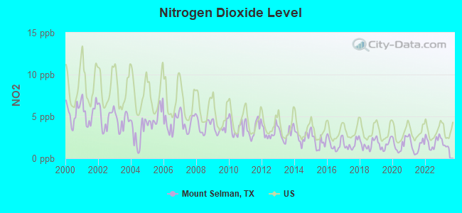
Nitrogen Dioxide (NO2) [ppb] level in 2022 was 1.96. This is significantly better than average. Closest monitor was 17.7 miles away from the city center.
| City: | 1.96 |
| U.S.: | 5.11 |
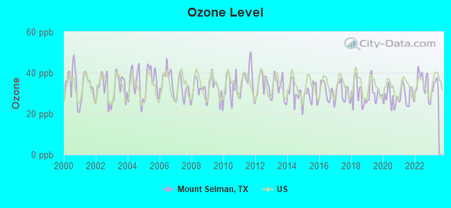
Ozone [ppb] level in 2022 was 34.7. This is about average. Closest monitor was 17.7 miles away from the city center.
| City: | 34.7 |
| U.S.: | 33.3 |
Tornado activity:
Mount Selman-area historical tornado activity is above Texas state average. It is 95% greater than the overall U.S. average.
On 4/26/1991, a category F3 (max. wind speeds 158-206 mph) tornado 3.9 miles away from the Mount Selman place center injured one person and caused between $50,000 and $500,000 in damages.
On 4/12/1955, a category F3 tornado 5.8 miles away from the place center injured 7 people and caused between $50,000 and $500,000 in damages.
Earthquake activity:
Mount Selman-area historical earthquake activity is significantly above Texas state average. It is 361% greater than the overall U.S. average.On 5/17/2012 at 08:12:00, a magnitude 4.8 (4.8 MW, Depth: 3.1 mi, Class: Light, Intensity: IV - V) earthquake occurred 57.8 miles away from Mount Selman center
On 11/6/2011 at 03:53:10, a magnitude 5.7 (5.7 MW, Depth: 3.2 mi, Class: Moderate, Intensity: VI - VII) earthquake occurred 251.3 miles away from the city center
On 9/3/2016 at 12:02:44, a magnitude 5.8 (5.8 MW, Depth: 3.5 mi) earthquake occurred 312.8 miles away from Mount Selman center
On 9/2/2013 at 23:51:15, a magnitude 4.3 (4.3 MW, Depth: 2.9 mi) earthquake occurred 54.7 miles away from Mount Selman center
On 9/2/2013 at 21:52:38, a magnitude 4.2 (4.2 MW, Depth: 3.0 mi) earthquake occurred 48.2 miles away from the city center
On 1/25/2013 at 07:01:19, a magnitude 4.1 (4.1 MB, Depth: 3.1 mi) earthquake occurred 63.2 miles away from the city center
Magnitude types: body-wave magnitude (MB), moment magnitude (MW)
Natural disasters:
The number of natural disasters in Cherokee County (20) is greater than the US average (15).Major Disasters (Presidential) Declared: 12
Emergencies Declared: 7
Causes of natural disasters: Storms: 8, Floods: 7, Hurricanes: 5, Tornadoes: 5, Fires: 4, Wind: 1, Winter Storm: 1, Other: 2 (Note: some incidents may be assigned to more than one category).
Hospitals and medical centers near Mount Selman:
- TWIN OAKS HEALTH AND REHABILITATION CENTER (Nursing Home, about 9 miles away; JACKSONVILLE, TX)
- MSHC BONNER STREET PLAZA, LLC (Nursing Home, about 11 miles away; JACKSONVILLE, TX)
- EAST TEXAS MEDICAL CENTER JACKSONVILLE Acute Care Hospitals (about 11 miles away; JACKSONVILLE, TX)
- LONGLEAF MEADOWS HEALTHCARE CENTER (Nursing Home, about 11 miles away; TYLER, TX)
- GARDENDALE REHABILITATION AND NURSING CENTER (Nursing Home, about 11 miles away; JACKSONVILLE, TX)
- OAK BROOK HEALTH CARE CENTER (Nursing Home, about 11 miles away; WHITEHOUSE, TX)
- HOMECARE NETWORK EAST INC (Home Health Center, about 11 miles away; JACKSONVILLE, TX)
Airports located in Mount Selman:
- Tarrant Field Airport (6X0) (Runways: 1, Itinerant Ops: 75, Local Ops: 400)
Colleges/universities with over 2000 students nearest to Mount Selman:
- The University of Texas at Tyler (about 16 miles; Tyler, TX; Full-time enrollment: 5,774)
- Tyler Junior College (about 17 miles; Tyler, TX; FT enrollment: 8,104)
- Trinity Valley Community College (about 32 miles; Athens, TX; FT enrollment: 5,333)
- Kilgore College (about 34 miles; Kilgore, TX; FT enrollment: 3,127)
- LeTourneau University (about 44 miles; Longview, TX; FT enrollment: 2,357)
- Stephen F Austin State University (about 57 miles; Nacogdoches, TX; FT enrollment: 11,542)
- Angelina College (about 67 miles; Lufkin, TX; FT enrollment: 3,478)
Points of interest:
Notable locations in Mount Selman: Mount Selman Speed Bowl (A), Lake Palestine East Volunteer Fire Department (B), North Cherokee County Volunteer Fire Department Station 1 (C). Display/hide their locations on the map
Churches in Mount Selman include: Taylors Chapel (A), Corinth Church (B), Mount Nebo Church (C), Mount Nevelton Church (D). Display/hide their locations on the map
Cemeteries: Tarrant Cemetery (1), Douglas Cemetery (2), Pleasant Hill Cemetery (3), Tecula Cemetery (4), Thompson Cemetery (5), Larissa Cemetery (6). Display/hide their locations on the map
Lakes and reservoirs: Stockton Lake (A), Brown Lake (B), Blackburn Pond (C), Hollywood Lake (D), Greenhead Lake (E), Brock Lake (F), Bullard Club Lake (G), Miles Lake (H). Display/hide their locations on the map
Streams, rivers, and creeks: Wallace Branch (A), Stone Chimney Creek (B), Rome Branch (C), Pierson Branch (D), Hetty Branch (E), Double Branch (F), Brushy Creek (G), Blue Branch (H), Birches Creek (I). Display/hide their locations on the map
| This place: | 2.6 people |
| Texas: | 2.8 people |
| This place: | 76.0% |
| Whole state: | 69.9% |
| This place: | 5.2% |
| Whole state: | 6.0% |
Likely homosexual households (counted as self-reported same-sex unmarried-partner households)
- Lesbian couples: 0.3% of all households
- Gay men: 0.5% of all households
| This place: | 13.9% |
| Whole state: | 15.4% |
| This place: | 3.8% |
| Whole state: | 6.7% |
For population 15 years and over in Mount Selman:
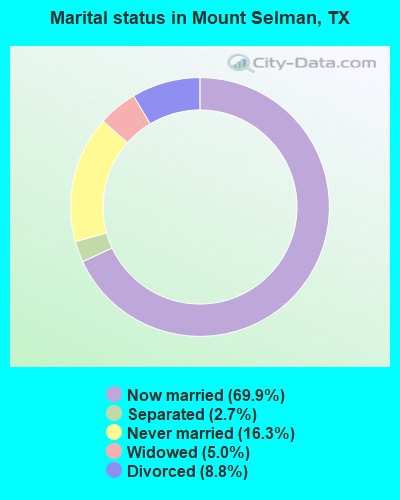
- Never married: 16.3%
- Now married: 69.9%
- Separated: 2.7%
- Widowed: 5.0%
- Divorced: 8.8%
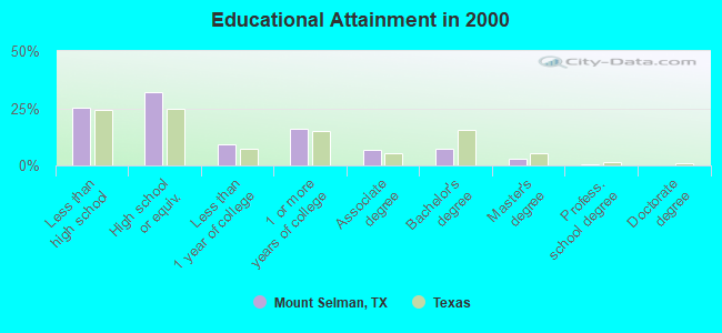
For population 25 years and over in Mount Selman:
- High school or higher: 74.6%
- Bachelor's degree or higher: 10.7%
- Graduate or professional degree: 3.4%
- Unemployed: 4.4%
- Mean travel time to work (commute): 29.7 minutes
| Here: | 10.4 |
| Texas average: | 15.6 |
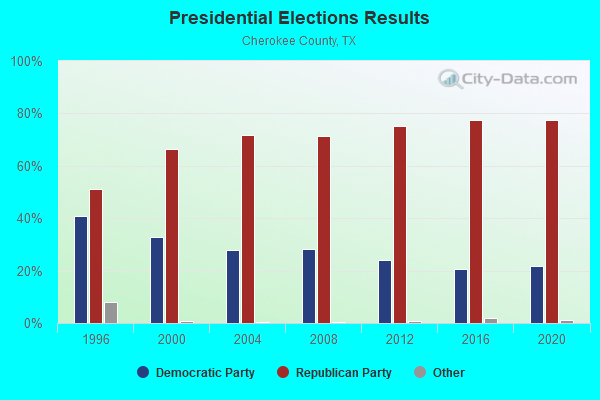
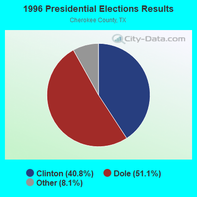
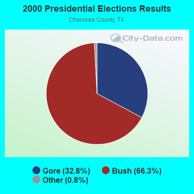
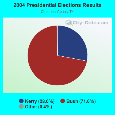

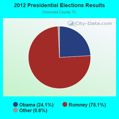
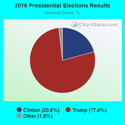
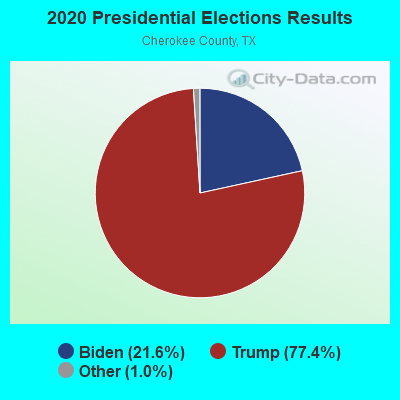
Graphs represent county-level data. Detailed 2008 Election Results
Religion statistics for Mount Selman, TX (based on Cherokee County data)

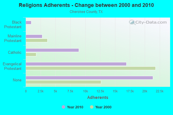
| Religion | Adherents | Congregations |
|---|---|---|
| Evangelical Protestant | 16,878 | 83 |
| Catholic | 8,917 | 4 |
| Mainline Protestant | 2,742 | 26 |
| Black Protestant | 922 | 11 |
| Orthodox | 18 | 1 |
| Other | 6 | 2 |
| None | 21,362 | - |
Food Environment Statistics:
| Here: | 1.25 / 10,000 pop. |
| State: | 1.47 / 10,000 pop. |
| Cherokee County: | 0.21 / 10,000 pop. |
| Texas: | 0.14 / 10,000 pop. |
| Cherokee County: | 1.46 / 10,000 pop. |
| Texas: | 1.11 / 10,000 pop. |
| Cherokee County: | 3.12 / 10,000 pop. |
| Texas: | 3.95 / 10,000 pop. |
| Cherokee County: | 4.37 / 10,000 pop. |
| State: | 6.13 / 10,000 pop. |
| Cherokee County: | 9.4% |
| State: | 8.9% |
| Cherokee County: | 27.4% |
| Texas: | 26.6% |
| This county: | 16.7% |
| Texas: | 15.7% |
Strongest AM radio stations in Mount Selman:
- KTBB (600 AM; 5 kW; TYLER, TX; Owner: CITADEL BROADCASTING COMPANY)
- KOFY (1060 AM; daytime; 10 kW; GILMER, TX; Owner: JERRY RUSSELL D/B/A THE RUSSELL COMPANY)
- KEBE (1400 AM; 1 kW; JACKSONVILLE, TX; Owner: WALLER BROADCASTING, INC.)
- KEEL (710 AM; 50 kW; SHREVEPORT, LA; Owner: CITICASTERS LICENSES, L.P.)
- KFXR (1190 AM; 50 kW; DALLAS, TX; Owner: CLEAR CHANNEL BROADCASTING LICENSES, INC.)
- KRLD (1080 AM; 50 kW; DALLAS, TX; Owner: TEXAS INFINITY BROADCASTING L.P.)
- KWKH (1130 AM; 50 kW; SHREVEPORT, LA; Owner: CITICASTERS LICENSES, L.P.)
- WBAP (820 AM; 50 kW; FORT WORTH, TX; Owner: WBAP-KSCS OPERATING, LTD.)
- KZEY (690 AM; 1 kW; TYLER, TX; Owner: COMMUNITY BROADCAST GROUP, INC.)
- KSKY (660 AM; 20 kW; BALCH SPRINGS, TX; Owner: BISON MEDIA, INC.)
- KWRD (1470 AM; 5 kW; HENDERSON, TX; Owner: JERRY RUSSELL D/B/A THE RUSSELL COMPANY)
- KESS (1270 AM; 50 kW; FORT WORTH, TX; Owner: KESS-AM LICENSE CORP.)
- KTRH (740 AM; 50 kW; HOUSTON, TX; Owner: AMFM TEXAS LICENSES LIMITED PARTNERSHIP)
Strongest FM radio stations in Mount Selman:
- KOOI (106.5 FM; JACKSONVILLE, TX; Owner: WALLER BROADCASTING, INC.)
- KBJS (90.3 FM; JACKSONVILLE, TX; Owner: EAST TEXAS MEDIA ASSOCIATION, INC.)
- KTYL-FM (93.1 FM; TYLER, TX; Owner: CAPSTAR TX LIMITED PARTNERSHIP)
- KOYE (96.7 FM; FRANKSTON, TX; Owner: WALLER MEDIA, LLC)
- KPXI (100.7 FM; OVERTON, TX; Owner: INSPIRATION MEDIA OF TEXAS, LLC)
- KNUE (101.5 FM; TYLER, TX; Owner: CAPSTAR TX LIMITED PARTNERSHIP)
- KISX (107.3 FM; WHITEHOUSE, TX; Owner: CAPSTAR TX LIMITED PARTNERSHIP)
- KGLY (91.3 FM; TYLER, TX; Owner: EDUC. RADIO FOUND. OF E. TEXAS, INC.)
- KLJT (102.3 FM; JACKSONVILLE, TX; Owner: WALLER BROADCASTING, INC.)
- KVNE (89.5 FM; TYLER, TX; Owner: EDUC. RADIO FOUND. OF E. TEXAS, INC.)
- K259AQ (99.7 FM; TYLER, TX; Owner: NORTH TEXAS PUBLIC BROADCASTING, INC.)
- KTPB (88.7 FM; KILGORE, TX; Owner: KILGORE JUNIOR COLLEGE)
- KBLZ (102.7 FM; WINONA, TX; Owner: S.O. 2,000, LC)
- KYKX (105.7 FM; LONGVIEW, TX; Owner: WALLER MEDIA, LLC)
- KYYK (98.3 FM; PALESTINE, TX; Owner: HIGHTOWER RADIO, INC.)
- K243AE (96.5 FM; TYLER, TX; Owner: CAPSTAR TX LIMITED PARTNERSHIP)
- KKTX-FM (96.1 FM; KILGORE, TX; Owner: CAPSTAR TX LIMITED PARTNERSHIP)
- KYFP (89.1 FM; PALESTINE, TX; Owner: BIBLE BROADCASTING NETWORK, INC.)
- KDOK (92.1 FM; TYLER, TX; Owner: CITADEL BROADCASTING COMPANY)
- KKUS (104.1 FM; TYLER, TX; Owner: WALLER MEDIA, LLC)
TV broadcast stations around Mount Selman:
- KETK-TV (Channel 56; JACKSONVILLE, TX; Owner: KETK LICENSEE L.P.)
- K26GA (Channel 26; TYLER/JACKSONVILLE, TX; Owner: THREE ANGELS BROADCASTING NETWORK)
- KLSB-TV (Channel 19; NACOGDOCHES, TX; Owner: KLSB ACQUISITION CORP.)
- KFXK (Channel 51; LONGVIEW, TX; Owner: WARWICK COMMUNICATIONS, INC.)
- KLTV (Channel 7; TYLER, TX; Owner: CIVCO, INC.)
- KTPN-LP (Channel 48; TYLER, TX; Owner: WARWICK COMMUNICATIONS, INC.)
- K20DL (Channel 20; TYLER, TX; Owner: PROGRESSIVE CABLE COMMUNICATIONS)
- KLPN-LP (Channel 58; LONGVIEW, TX; Owner: WARWICK COMMUNICATIONS, INC.)
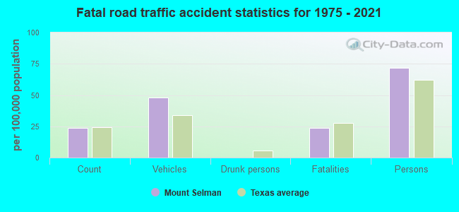
Mount Selman fatal accident list:
FCC Registered Antenna Towers:
10 (See the full list of FCC Registered Antenna Towers in Mount Selman)FCC Registered Broadcast Land Mobile Towers:
1- 1.8 Mi W Of Mount Selmand And S Of Hwy 855 (Lat: 32.061389 Lon: -95.314167), Type: Tower, Structure height: 445 m, Overall height: 447 m, Call Sign: WPIB884,
Assigned Frequencies: 937.400 MHz, 937.437 MHz, 937.462 MHz, Grant Date: 06/03/2015, Expiration Date: 08/23/2025, Certifier: David Poole, Registrant: Oncor / Hcl, 1616 Woodall Rodgers Freeway, Dallas, TX 75202, Phone: (214) 486-5230, Email:
FCC Registered Microwave Towers:
7- 1.8 Mi W (Lat: 32.061250 Lon: -95.314111), Structure height: 429.2 m, Overall height: 447.1 m, Call Sign: WPNJ352,
Assigned Frequencies: 21825.0 MHz, Grant Date: 10/09/2002, Expiration Date: 12/09/2012, Cancellation Date: 02/09/2013, Registrant: Shaw Pittman LLP, 2300 N Street, Nw, Washington, DC 20037-1128, Phone: (202) 663-8217, Fax: (202) 663-8007, Email:
- Mt. Selman Tower, 1.8 Mi W Of Mount Selman And S Of Hwy 855 (Lat: 32.061389 Lon: -95.314167), Type: Tower, Structure height: 445 m, Overall height: 447 m, Call Sign: WQDF351,
Assigned Frequencies: 7050.00 MHz, Grant Date: 08/10/2005, Expiration Date: 08/01/2022, Certifier: Wayne Elmore, Registrant: Nexstar Media Inc., 545 E. John Carpenter Freeway, Suite 700, Irving, TX 75062, Phone: (972) 373-8800, Fax: (972) 373-8888, Email:
- Mt Selman, 1.8 Mi W Of Mount Selmand And S Of Hwy 855 (Lat: 32.061389 Lon: -95.314167), Type: Tower, Structure height: 445 m, Overall height: 447 m, Call Sign: WQFN349,
Assigned Frequencies: 7100.00 MHz, Grant Date: 08/22/2006, Expiration Date: 08/01/2030, Certifier: Sheldon H Galloway, Registrant: Cozen O\'Connor, 277 Park Avenue, New York, NY 10172, Phone: (212) 883-4923, Fax: (866) 316-9689, Email:
- ketk xmtr, 1.8 Mi W Of Mount Selmand And S Of Hwy 855 (Lat: 32.061389 Lon: -95.314167), Type: Tower, Structure height: 445 m, Overall height: 447 m, Call Sign: WQLJ754, Grant Date: 02/16/2010, Expiration Date: 08/01/2022, Certifier: Greg Boulanger, Registrant: Nexstar Media Inc., 545 E. John Carpenter Freeway, Irving, TX 75062, Phone: (972) 373-8800, Fax: (972) 373-8888, Email:
- Lone Star, 1.8 Mi W Of Mount Selmand And S Of Hwy 855 (Lat: 32.061389 Lon: -95.314167), Type: Gtower, Structure height: 445 m, Overall height: 447 m, Call Sign: WRAQ808,
Assigned Frequencies: 6063.80 MHz, 6004.50 MHz, Grant Date: 02/01/2018, Expiration Date: 02/01/2028, Certifier: Dennis Skruhak, Registrant: Keller And Heckman LLP, 1001 G Street Nw, Suite 500 West, Washington, DC 20001, Phone: (202) 434-4100, Fax: (202) 434-4646, Email:
- Mt SELMAN, 1.8 Mi W Of Mount Selmand And S Of Hwy 855 (Lat: 32.061389 Lon: -95.314167), Type: Ltower, Structure height: 445 m, Overall height: 447 m, Call Sign: WRCM840,
Assigned Frequencies: 6555.00 MHz, 6555.00 MHz, 6555.00 MHz, 6555.00 MHz, Grant Date: 11/14/2018, Expiration Date: 11/14/2028, Certifier: Don J Clevenger, Registrant: Micronet Communications, Inc., 812 Lexington Dr, Plano, TX 75075, Phone: (972) 422-7200, Email:
- KETK Tower, 1.8 Mi W Of Mount Selmand And S Of Hwy 855 (Lat: 32.061389 Lon: -95.314167), Type: Tower, Structure height: 445 m, Overall height: 447 m, Call Sign: KC23616, Grant Date: 09/24/1987, Expiration Date: 08/01/2022, Registrant: Nexstar Media Inc., 545 E. John Carpenter Freeway, Suite 700, Irving, TX 75062, Phone: (972) 373-8800, Fax: (972) 373-8888, Email:
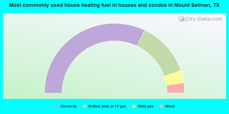
- 64.2%Electricity
- 25.3%Bottled, tank, or LP gas
- 5.7%Utility gas
- 4.8%Wood
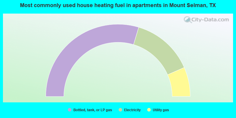
- 59.3%Bottled, tank, or LP gas
- 27.6%Electricity
- 13.1%Utility gas
Mount Selman compared to Texas state average:
- Median house value below state average.
- Unemployed percentage significantly below state average.
- Black race population percentage below state average.
- Hispanic race population percentage significantly below state average.
- Median age above state average.
- Foreign-born population percentage significantly below state average.
- Renting percentage significantly below state average.
- Length of stay since moving in significantly above state average.
- Number of rooms per house significantly below state average.
- House age significantly below state average.
- Number of college students below state average.
- Percentage of population with a bachelor's degree or higher below state average.