Hanover, Montana
Submit your own pictures of this place and show them to the world
- OSM Map
- General Map
- Google Map
- MSN Map

| Males: 376 | |
| Females: 327 |
| Median resident age: | 39.7 years |
| Montana median age: | 37.5 years |
Zip code: 59451
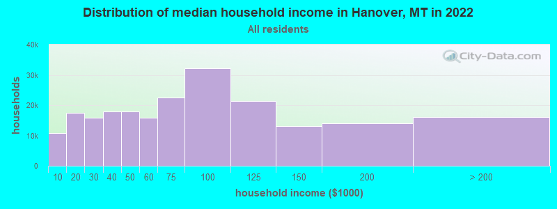
| Hanover: | $59,877 |
| MT: | $67,631 |
Estimated per capita income in 2022: $29,562 (it was $13,206 in 2000)
Hanover CCD income, earnings, and wages data
Estimated median house or condo value in 2022: $200,886 (it was $67,500 in 2000)
| Hanover: | $200,886 |
| MT: | $366,400 |
Detailed information about poverty and poor residents in Hanover, MT


- 72797.5%White alone
- 101.3%Hispanic
- 50.7%Two or more races
- 30.4%American Indian alone
- 10.1%Asian alone

Races in Hanover detailed stats: ancestries, foreign born residents, place of birth
 Recent articles from our blog. Our writers, many of them Ph.D. graduates or candidates, create easy-to-read articles on a wide variety of topics.
Current Local Time: MST time zone
Elevation: 3752 feet
Land area: 595.6 square miles.
Population density: 1.2 people per square mile (very low).

| Hanover CCD: | 0.8% ($550) |
| Montana: | 1.3% ($1,212) |
Nearest city with pop. 50,000+: Great Falls, MT  (89.1 miles , pop. 56,690).
Nearest city with pop. 200,000+: West Adams, CO (554.9 miles , pop. 259,628).
Nearest city with pop. 1,000,000+: Phoenix, AZ (957.7 miles , pop. 1,321,045).
Nearest cities:
), ), ), Latitude: 47.23 N, Longitude: 109.43 W
Area code commonly used in this area: 406

| Here: | 3.8% |
| Montana: | 3.8% |

- Agriculture, forestry, fishing & hunting (53.9%)
- Health care (8.3%)
- Educational services (7.3%)
- Public administration (4.0%)
- Construction (3.1%)
- Accommodation & food services (2.8%)
- Food & beverage stores (2.1%)

- Agriculture, forestry, fishing & hunting (68.0%)
- Construction (5.1%)
- Accommodation & food services (3.5%)
- Public administration (3.1%)
- Utilities (2.7%)
- Food & beverage stores (2.0%)
- Educational services (2.0%)

- Agriculture, forestry, fishing & hunting (32.3%)
- Health care (19.8%)
- Educational services (15.6%)
- Public administration (5.4%)
- Professional, scientific, technical services (4.2%)
- Farm product raw materials merchant wholesalers (2.4%)
- Food & beverage stores (2.4%)

- Farmers and farm managers (37.4%)
- Building and grounds cleaning and maintenance occupations (7.1%)
- Agricultural workers, including supervisors (7.1%)
- Cooks and food preparation workers (4.5%)
- Registered nurses (3.3%)
- Other management occupations, except farmers and farm managers (2.4%)
- Electrical equipment mechanics and other installation, maintenance, and repair workers, including supervisors (2.4%)

- Farmers and farm managers (54.7%)
- Agricultural workers, including supervisors (10.2%)
- Electrical equipment mechanics and other installation, maintenance, and repair workers, including supervisors (3.9%)
- Construction traders workers except carpenters, electricians, painters, plumbers, and construction laborers (3.1%)
- Top executives (2.3%)
- Pipelayers, plumbers, pipefitters, and steamfitters (2.3%)
- Other sales and related occupations, including supervisors (2.0%)

- Building and grounds cleaning and maintenance occupations (16.2%)
- Farmers and farm managers (10.8%)
- Cooks and food preparation workers (10.2%)
- Registered nurses (7.2%)
- Other healthcare support occupations (5.4%)
- Other management occupations, except farmers and farm managers (4.8%)
- Bookkeeping, accounting, and auditing clerks (4.8%)
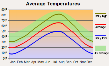
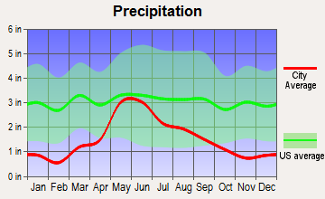
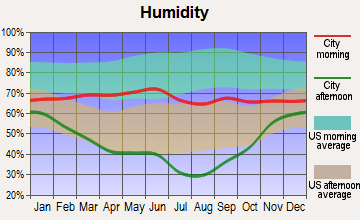
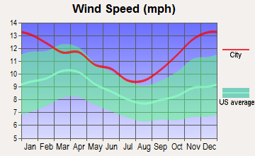
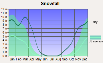
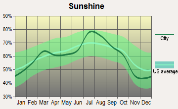
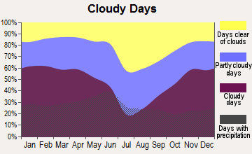
Average climate in Hanover, Montana
Based on data reported by over 4,000 weather stations
(lower is better)

Air Quality Index (AQI) level in 2022 was 53.7. This is better than average.
| City: | 53.7 |
| U.S.: | 72.6 |

Nitrogen Dioxide (NO2) [ppb] level in 2022 was 0.561. This is significantly better than average. Closest monitor was 12.6 miles away from the city center.
| City: | 0.561 |
| U.S.: | 5.109 |

Ozone [ppb] level in 2022 was 36.9. This is about average. Closest monitor was 12.6 miles away from the city center.
| City: | 36.9 |
| U.S.: | 33.3 |

Particulate Matter (PM10) [µg/m3] level in 2022 was 9.52. This is significantly better than average. Closest monitor was 3.4 miles away from the city center.
| City: | 9.52 |
| U.S.: | 19.21 |

Particulate Matter (PM2.5) [µg/m3] level in 2022 was 4.59. This is significantly better than average. Closest monitor was 12.6 miles away from the city center.
| City: | 4.59 |
| U.S.: | 8.11 |
Earthquake activity:
Hanover-area historical earthquake activity is significantly above Montana state average. It is 581% greater than the overall U.S. average.On 8/18/1959 at 06:37:13, a magnitude 7.7 (7.7 UK, Class: Major, Intensity: VIII - XII) earthquake occurred 193.5 miles away from Hanover center, causing $26,000,000 total damage
On 10/28/1983 at 14:06:06, a magnitude 7.3 (6.2 MB, 7.3 MS, 7.0 MW) earthquake occurred 303.7 miles away from Hanover center, causing 2 deaths (2 shaking deaths) and 3 injuries, causing $15,000,000 total damage
On 6/30/1975 at 18:54:13, a magnitude 6.1 (5.6 MB, 5.9 MS, 6.1 UK, 6.1 ML, Class: Strong, Intensity: VII - IX) earthquake occurred 187.7 miles away from Hanover center
On 7/6/2017 at 06:30:17, a magnitude 5.8 (5.8 MW, Depth: 7.6 mi, Class: Moderate, Intensity: VI - VII) earthquake occurred 150.3 miles away from Hanover center
On 3/31/2020 at 23:52:30, a magnitude 6.5 (6.5 MW, Depth: 7.5 mi) earthquake occurred 334.1 miles away from the city center
On 7/26/2005 at 04:08:37, a magnitude 5.7 (5.7 MB, 5.2 MS, 5.6 MW) earthquake occurred 196.6 miles away from Hanover center
Magnitude types: body-wave magnitude (MB), local magnitude (ML), surface-wave magnitude (MS), moment magnitude (MW)
Natural disasters:
The number of natural disasters in Fergus County (7) is smaller than the US average (15).Major Disasters (Presidential) Declared: 5
Emergencies Declared: 1
Causes of natural disasters: Floods: 4, Storms: 2, Fire: 1, Heavy Rain: 1, Hurricane: 1, Landslide: 1, Snow: 1, Other: 1 (Note: some incidents may be assigned to more than one category).
Hospitals and medical centers near Hanover:
- CENTRAL MONTANA MC HOME HEALTH (Home Health Center, about 12 miles away; LEWISTOWN, MT)
- CENTRAL MONTANA MEDICAL CTR (Hospital, about 12 miles away; LEWISTOWN, MT)
- CENTRAL MONTANA SKILLED NURSING (Nursing Home, about 12 miles away; LEWISTOWN, MT)
- MONTANA MENTAL HEALTH NURSING HOME (Nursing Home, about 12 miles away; LEWISTOWN, MT)
- VALLE VISTA MANOR (Nursing Home, about 13 miles away; LEWISTOWN, MT)
Colleges/universities with over 2000 students nearest to Hanover:
- Montana State University-Billings (about 109 miles; Billings, MT; Full-time enrollment: 4,319)
- Montana State University (about 133 miles; Bozeman, MT; FT enrollment: 12,942)
- Sheridan College (about 209 miles; Sheridan, WY; FT enrollment: 2,070)
- The University of Montana (about 217 miles; Missoula, MT; FT enrollment: 13,602)
- Brigham Young University-Idaho (about 263 miles; Rexburg, ID; FT enrollment: 30,522)
- Black Hills State University (about 328 miles; Spearfish, SD; FT enrollment: 3,166)
- Idaho State University (about 336 miles; Pocatello, ID; FT enrollment: 10,350)
Points of interest:
Notable locations in Hanover: Maiden Fur Farm (A), The Horse Ranch (B), Roy Junction (C), Amherst (D), Hruska Fishing Access Site (E), Spring Creek Colony (F), Ruins of Fort Maginnis (G), Hilger Fire Department (H). Display/hide their locations on the map
Churches in Hanover include: Saint Victor Church (A), Presbyterian Church (B). Display/hide their locations on the map
Cemeteries: Fort Maginnis Cemetery (1), Gilt Edge Cemetery (2), Kendall Cemetery (3), Hilger Cemetery (4). Display/hide their locations on the map
Creeks: Cottonwood Creek (A), West Fork Salt Creek (B), East Fork Salt Creek (C), Middle Fork Salt Creek (D), Big Spring Creek (E), Alkali Creek (F), Box Elder Creek (G), Burnette Creek (H), Coyote Creek (I). Display/hide their locations on the map
| This place: | 2.3 people |
| Montana: | 2.4 people |
| This place: | 75.0% |
| Whole state: | 62.8% |
| This place: | 3.1% |
| Whole state: | 6.7% |
Likely homosexual households (counted as self-reported same-sex unmarried-partner households)
- Lesbian couples: 0.0% of all households
- Gay men: 0.4% of all households
| This place: | 26.0% |
| Whole state: | 14.6% |
| This place: | 8.9% |
| Whole state: | 5.8% |
86 people in agriculture workers' dormitories on farms in 2000
For population 15 years and over in Hanover:

- Never married: 26.0%
- Now married: 64.6%
- Separated: 0.3%
- Widowed: 1.9%
- Divorced: 7.5%
For population 25 years and over in Hanover:
- High school or higher: 85.2%
- Bachelor's degree or higher: 15.8%
- Graduate or professional degree: 1.7%
- Unemployed: 1.4%
- Mean travel time to work (commute): 14.6 minutes


| Here: | 10.2 |
| Montana average: | 10.4 |
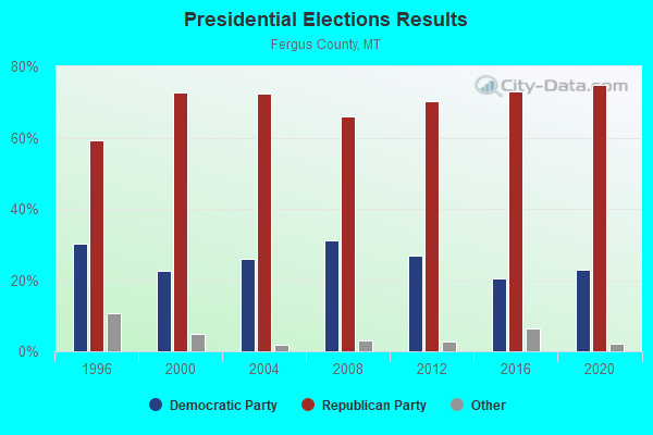
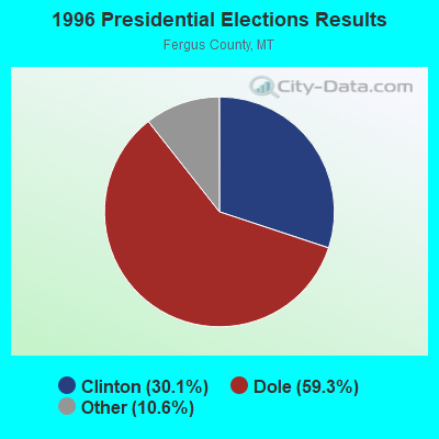

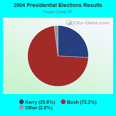
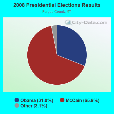
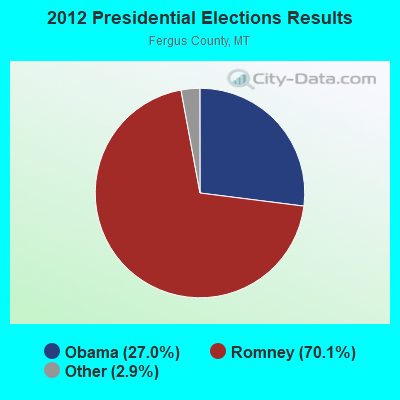
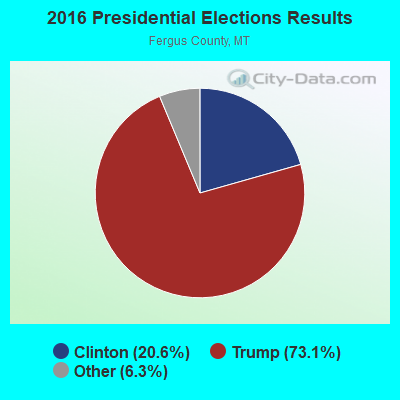
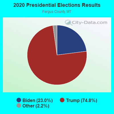
Graphs represent county-level data. Detailed 2008 Election Results
Religion statistics for Hanover, MT (based on Fergus County data)
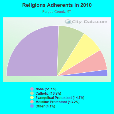
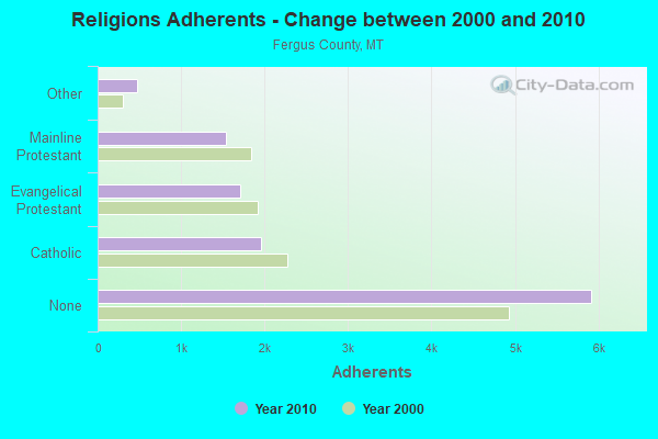
| Religion | Adherents | Congregations |
|---|---|---|
| Catholic | 1,954 | 6 |
| Evangelical Protestant | 1,708 | 20 |
| Mainline Protestant | 1,535 | 10 |
| Other | 470 | 2 |
| None | 5,919 | - |
Food Environment Statistics:
| Fergus County: | 5.37 / 10,000 pop. |
| Montana: | 2.55 / 10,000 pop. |
| This county: | 4.48 / 10,000 pop. |
| State: | 4.69 / 10,000 pop. |
| Here: | 15.23 / 10,000 pop. |
| State: | 10.38 / 10,000 pop. |
| This county: | 8.9% |
| State: | 7.2% |
| This county: | 23.6% |
| Montana: | 23.1% |
| This county: | 5.3% |
| Montana: | 10.7% |
Strongest AM radio stations in Hanover:
- KXLO (1230 AM; 1 kW; LEWISTOWN, MT; Owner: KXLO BROADCAST, INC.)
- KERR (750 AM; 50 kW; POLSON, MT; Owner: ANDERSON RADIO BROADCASTING, INC.)
- KMON (560 AM; 5 kW; GREAT FALLS, MT; Owner: COMMONWEALTH LICENSE SUBSIDIARY, LLC)
- KGVW (640 AM; 10 kW; BELGRADE, MT; Owner: GALLATIN VALLEY WITNESS, INC.)
- KOFI (1180 AM; 50 kW; KALISPELL, MT; Owner: KOFI, INC.)
- KURL (730 AM; 5 kW; BILLINGS, MT; Owner: ELENBAAS MEDIA, INC.)
- KGHL (790 AM; 5 kW; BILLINGS, MT; Owner: NEW NORTHWEST BROADCASTERS, LLC)
- KKGR (680 AM; daytime; 5 kW; EAST HELENA, MT; Owner: KKGR, INC.)
- KEIN (1310 AM; 5 kW; GREAT FALLS, MT; Owner: MUNSON RADIO, INC.)
- KSEN (1150 AM; 10 kW; SHELBY, MT; Owner: CAPSTAR TX LIMITED PARTNERSHIP)
- KTWO (1030 AM; 50 kW; CASPER, WY; Owner: CITICASTERS LICENSES, L.P.)
- KBUL (970 AM; 5 kW; BILLINGS, MT; Owner: CAPSTAR TX LIMITED PARTNERSHIP)
- KBOI (670 AM; 50 kW; BOISE, ID; Owner: CITADEL BROADCASTING COMPANY)
Strongest FM radio stations in Hanover:
- KEHT (100.3 FM; GREAT FALLS, MT; Owner: GEORGE S. FLINN, JR.)
- K203AE (88.5 FM; LEWISTOWN, MT; Owner: MONTANA STATE UNIVERSITY-BILLINGS)
TV broadcast stations around Hanover:
- KBAO (Channel 13; LEWISTOWN, MT; Owner: SUNBELT COMMUNICATIONS COMPANY)
- K43DC (Channel 43; LEWISTOWN, MT; Owner: KFBB CORPORATION)
- K47DP (Channel 47; LEWISTOWN, MT; Owner: MMM LICENSE LLC)
- K45CS (Channel 45; LEWISTOWN, MT; Owner: KRTV COMMUNICATIONS, INC.)
- K29AA (Channel 13; LEWISTOWN, MT; Owner: BLACKTAIL TV TAX DISTRICT)
FCC Registered Antenna Towers:
2- Ne 1/4 Of Sw 1/4 Of Section 2, T16n, R17e, Fergus County (Lat: 47.177778 Lon: -109.536111), Type: 60.7, Overall height: 60.7 m, Registrant: Sunbelt Broadcasting Company, Las V-egas, Phone: (702) 642-3333
- Ne 1/4 Of Sw 1/4 Of Section 2, T16n, R17e, Fergus County (Lat: 47.177778 Lon: -109.536111), Type: 10.4, Overall height: 6.1 m, Registrant: Sunbelt Broadcasting Company, Las V-egas, Phone: (702) 642-3333
FCC Registered Microwave Towers:
1- HANOVER, 1.1 Mi Ne (Lat: 47.134139 Lon: -109.539333), Overall height: 8.5 m, Call Sign: WFY529,
Assigned Frequencies: 11325.0 MHz, 11565.0 MHz, 11325.0 MHz, 11565.0 MHz, Grant Date: 09/06/2000, Expiration Date: 08/01/2010, Cancellation Date: 10/25/2001, Registrant: Qwest Corporation, 700 W. Mineral Avenue, Room Co G1.24, Littleton, CO 80120, Phone: (303) 707-8706, Fax: (303) 707-9775, Email:
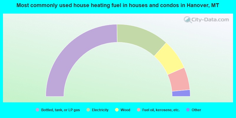
- 49.5%Bottled, tank, or LP gas
- 23.7%Electricity
- 13.6%Wood
- 10.1%Fuel oil, kerosene, etc.
- 1.5%Coal or coke
- 1.0%Other fuel
- 0.5%Utility gas
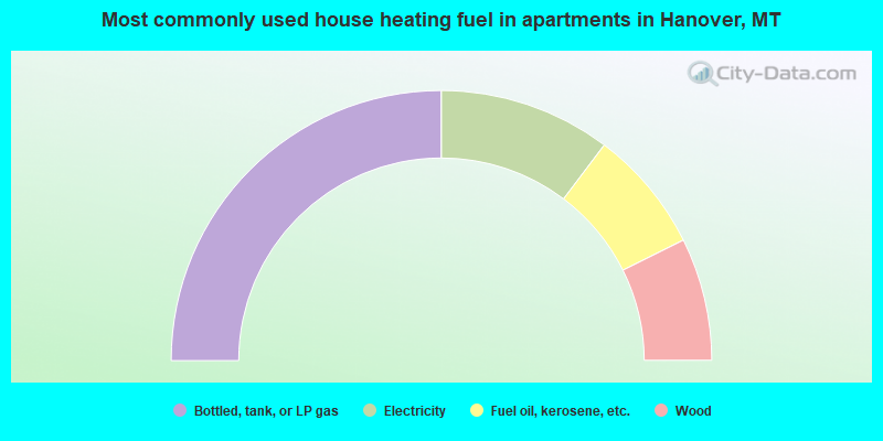
- 50.0%Bottled, tank, or LP gas
- 20.6%Electricity
- 14.7%Fuel oil, kerosene, etc.
- 14.7%Wood
Hanover compared to Montana state average:
- Median house value below state average.
- Unemployed percentage significantly below state average.
- Black race population percentage significantly below state average.
- Hispanic race population percentage significantly below state average.
- Foreign-born population percentage significantly below state average.
- Renting percentage below state average.
- Length of stay since moving in significantly above state average.
- Number of rooms per house significantly below state average.
- House age significantly below state average.
- Number of college students significantly below state average.
- Percentage of population with a bachelor's degree or higher below state average.
Hanover on our top lists:
- #25 on the list of "Top 101 cities with the most cars per house, population 500+"
- #1 on the list of "Top 101 counties with the lowest Particulate Matter (PM10) Annual air pollution readings in 2012 (µg/m3)"
- #3 on the list of "Top 101 counties with the lowest Particulate Matter (PM2.5) Annual air pollution readings in 2012 (µg/m3)"
- #5 on the list of "Top 101 counties with the lowest surface withdrawal of fresh water for public supply"
- #27 on the list of "Top 101 counties with the lowest Nitrogen Dioxide air pollution readings in 2012 (ppm)"
- #45 on the list of "Top 101 counties with the lowest Ozone (1-hour) air pollution readings in 2012 (ppm)"