Freetown, Massachusetts
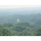
Freetown: View from profile rock( freetown forest)
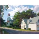
Freetown: Congregational-Christian Church and Parsonage in East Freetown
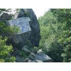
Freetown: Profile rock (freetown forest)

Freetown: Assonet Bay Sunset
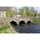
Freetown: Elm Street Bridge - constructed 1822
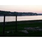
Freetown: Assonet Bay Sunset 2
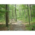
Freetown: Walk in the woods( freetown forest)
Freetown: townsend, ma
- add
your
Submit your own pictures of this town and show them to the world
- OSM Map
- Google Map
- MSN Map
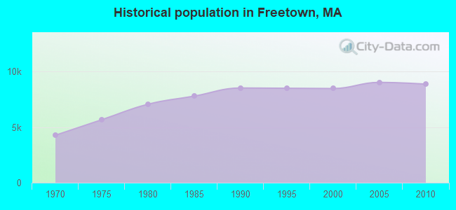
Population change since 2000: +4.7%
 |
| Males: 4,452 | |
| Females: 4,418 |
| Median resident age: | 42.4 years |
| Massachusetts median age: | 39.2 years |
Zip codes: 02702.
| Freetown: | $121,074 |
| MA: | $94,488 |
Estimated per capita income in 2022: $49,421 (it was $24,237 in 2000)
Freetown town income, earnings, and wages data
Estimated median house or condo value in 2022: $481,044 (it was $163,800 in 2000)
| Freetown: | $481,044 |
| MA: | $534,700 |
Mean prices in 2022: all housing units: $449,660; detached houses: $484,124; townhouses or other attached units: $382,766; in 2-unit structures: $322,469; in 3-to-4-unit structures: $355,875; in 5-or-more-unit structures: $269,714; mobile homes: $156,871; occupied boats, rvs, vans, etc.: $49,834
Detailed information about poverty and poor residents in Freetown, MA
Compare current foreclosures near Freetown, MA:
| Photo | Address | Area | Beds / Baths | Price | Details |
|---|---|---|---|---|---|

|
#1
Somerset Ave
Taunton, MA 02780
|
3,196 sq. feet
|
3 baths 4 beds |
$754,900
|
show details |

|
#2
County St
East Taunton, MA 02718
|
1,157 sq. feet
|
1 baths 1 beds |
$219,900
|
show details |

|
#3
Peckham St
New Bedford, MA 02746
|
3,089 sq. feet
|
3 baths 9 beds |
show details | |

|
#4
Melville St
Fall River, MA 02724
|
2,733 sq. feet
|
3 baths 6 beds |
show details | |

|
#5
Willis St
New Bedford, MA 02740
|
1,973 sq. feet
|
2 baths 4 beds |
show details | |

|
#6
Woodland Ave
Seekonk, MA 02771
|
4,611 sq. feet
|
4 baths 4 beds |
show details | |

|
#7
Belleville Rd
New Bedford, MA 02745
|
- sq. feet
|
2 baths 5 beds |
show details | |

|
#8
Terry Ln E
Wareham, MA 02571
|
1,412 sq. feet
|
1 baths 4 beds |
show details | |

|
#9
Boyds Ln
Portsmouth, RI 02871
|
1,144 sq. feet
|
1 baths 3 beds |
show details | |

|
#10
Powhattan Dr
East Taunton, MA 02718
|
1,632 sq. feet
|
1 baths 3 beds |
show details |
| Photo | Address | Area | Beds / Baths | Price | Details |
|---|---|---|---|---|---|

|
#11
Swifts Beach Road A/k/a 84 Swift S Beach Road
Wareham, MA 02571
|
- sq. feet
|
1 baths 3 beds |
show details | |

|
#12
Bay St
Fall River, MA 02724
|
1,848 sq. feet
|
1 baths 3 beds |
show details | |

|
#13
Dwinell Rd
Taunton, MA 02780
|
1,632 sq. feet
|
2 baths 4 beds |
show details | |

|
#14
Detroit Ave
Warren, RI 02885
|
1,518 sq. feet
|
1 baths 3 beds |
show details | |

|
#15
N Main St
Middleboro, MA 02346
|
1,898 sq. feet
|
2 baths 4 beds |
show details | |

|
#16
Oak St
New Bedford, MA 02740
|
1,460 sq. feet
|
2 baths 3 beds |
show details | |

|
#17
Ashland St
Taunton, MA 02780
|
1,680 sq. feet
|
2 baths 4 beds |
show details | |

|
#18
Homestead Ave
Acushnet, MA 02743
|
936 sq. feet
|
1 baths 3 beds |
show details | |

|
#19
Point Rd
Marion, MA 02738
|
660 sq. feet
|
1 baths 2 beds |
show details | |

|
#20
Gifford Ave
North Dartmouth, MA 02747
|
1,518 sq. feet
|
1 baths 4 beds |
show details |
| Photo | Address | Area | Beds / Baths | Price | Details |
|---|---|---|---|---|---|

|
#21
Mill St
New Bedford, MA 02740
|
1,542 sq. feet
|
1 baths 3 beds |
show details | |

|
#22
Chace Ave
Warren, RI 02885
|
1,224 sq. feet
|
1 baths 2 beds |
show details | |

|
#23
Mayo Dr
Warren, RI 02885
|
1,739 sq. feet
|
1 baths 3 beds |
show details | |

|
#24
Everett St
Middleboro, MA 02346
|
1,188 sq. feet
|
1 baths 3 beds |
show details | |

|
#25
Spruce St
Middleboro, MA 02346
|
1,846 sq. feet
|
3 baths 4 beds |
show details | |

|
#26
County St
New Bedford, MA 02740
|
2,624 sq. feet
|
4 baths 4 beds |
show details | |

|
#27
Cedar St
Rehoboth, MA 02769
|
3,606 sq. feet
|
3 baths 4 beds |
show details | |

|
#28
Whittier St
Fall River, MA 02724
|
972 sq. feet
|
1 baths 2 beds |
show details | |

|
#29
Dellawanda Rd
Swansea, MA 02777
|
1,052 sq. feet
|
1 baths 2 beds |
show details | |

|
#30
Oak St
Middleboro, MA 02346
|
1,589 sq. feet
|
2 baths 3 beds |
show details |
| Photo | Address | Area | Beds / Baths | Price | Details |
|---|---|---|---|---|---|

|
#31
Hedge St
Fairhaven, MA 02719
|
878 sq. feet
|
1 baths 2 beds |
show details | |

|
#32
Reed St
New Bedford, MA 02740
|
1,742 sq. feet
|
1 baths 4 beds |
show details | |

|
#33
Chancery St
New Bedford, MA 02740
|
1,327 sq. feet
|
1 baths 3 beds |
show details | |

|
#34
Benson St
Middleboro, MA 02346
|
1,456 sq. feet
|
1 baths 3 beds |
show details | |

|
#35
Main St
Fairhaven, MA 02719
|
2,412 sq. feet
|
2 baths 4 beds |
show details | |

|
#36
Townsend St
Fall River, MA 02724
|
1,040 sq. feet
|
1 baths 3 beds |
show details | |

|
#37
Wareham St
Middleboro, MA 02346
|
1,114 sq. feet
|
1 baths 1 beds |
show details | |

|
#38
Chestnut St
New Bedford, MA 02740
|
2,860 sq. feet
|
2 baths 4 beds |
show details | |

|
#39
Forest St
Middleboro, MA 02346
|
1,343 sq. feet
|
2 baths 3 beds |
show details | |

|
#40
Rounds St
New Bedford, MA 02740
|
1,450 sq. feet
|
1 baths 4 beds |
show details |
| Photo | Address | Area | Beds / Baths | Price | Details |
|---|---|---|---|---|---|

|
#41
Appleton St
Fall River, MA 02724
|
662 sq. feet
|
1 baths 3 beds |
show details | |

|
#42
Mariano Bishop Blvd
Fall River, MA 02721
|
1,085 sq. feet
|
1 baths 3 beds |
show details | |

|
#43
Sproat St
Middleboro, MA 02346
|
1,574 sq. feet
|
1 baths 3 beds |
show details | |

|
#44
Ridgecrest Ave
Fairhaven, MA 02719
|
2,524 sq. feet
|
4 baths 4 beds |
show details | |

|
#45
Marchand Way
Norton, MA 02766
|
1,296 sq. feet
|
2 baths 2 beds |
show details | |

|
#46
Monroe St
Taunton, MA 02780
|
900 sq. feet
|
1 baths 2 beds |
show details | |

|
#47
Vinnicum Rd
Swansea, MA 02777
|
1,867 sq. feet
|
1 baths 2 beds |
show details | |

|
#48
Bolton St
New Bedford, MA 02740
|
1,072 sq. feet
|
1 baths 2 beds |
show details | |

|
#49
Winterville Rd
New Bedford, MA 02740
|
993 sq. feet
|
1 baths 3 beds |
show details | |

|
Check over 1 million property listings on Foreclosure.com!
|
browse all offers | |||

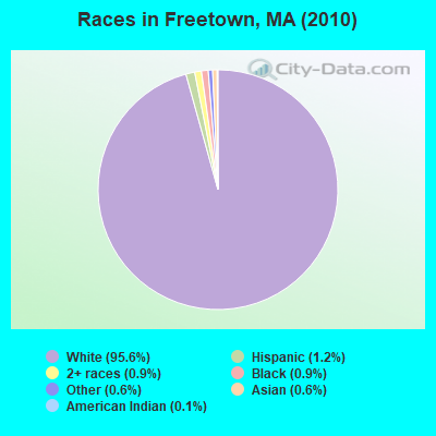
- 8,48095.6%White alone
- 1091.2%Hispanic
- 770.9%Black alone
- 830.9%Two or more races
- 550.6%Asian alone
- 570.6%Other race alone
- 90.1%American Indian alone
Races in Freetown detailed stats: ancestries, foreign born residents, place of birth
According to our research of Massachusetts and other state lists, there was 1 registered sex offender living in Freetown, Massachusetts as of May 28, 2024.
The ratio of all residents to sex offenders in Freetown is 8,870 to 1.
The ratio of registered sex offenders to all residents in this city is much lower than the state average.
Type |
2009 |
2010 |
2011 |
2012 |
2013 |
2014 |
2015 |
2016 |
2017 |
2018 |
2019 |
2020 |
2021 |
2022 |
|---|---|---|---|---|---|---|---|---|---|---|---|---|---|---|
| Murders (per 100,000) | 0 (0.0) | 0 (0.0) | 0 (0.0) | 0 (0.0) | 0 (0.0) | 0 (0.0) | 0 (0.0) | 0 (0.0) | 0 (0.0) | 0 (0.0) | 0 (0.0) | 0 (0.0) | 0 (0.0) | 0 (0.0) |
| Rapes (per 100,000) | 2 (22.0) | 1 (11.3) | 0 (0.0) | 0 (0.0) | 3 (33.3) | 2 (22.0) | 3 (32.8) | 3 (32.6) | 4 (42.8) | 4 (42.5) | 5 (53.3) | 1 (10.6) | 4 (41.8) | 2 (21.6) |
| Robberies (per 100,000) | 2 (22.0) | 4 (45.1) | 1 (11.2) | 2 (22.3) | 2 (22.2) | 2 (22.0) | 2 (21.9) | 2 (21.7) | 2 (21.4) | 1 (10.6) | 2 (21.3) | 0 (0.0) | 0 (0.0) | 0 (0.0) |
| Assaults (per 100,000) | 32 (351.5) | 28 (315.7) | 14 (156.9) | 10 (111.6) | 16 (177.9) | 21 (230.8) | 21 (229.5) | 16 (173.9) | 17 (182.0) | 19 (202.0) | 8 (85.2) | 19 (202.1) | 12 (125.4) | 22 (237.9) |
| Burglaries (per 100,000) | 48 (527.3) | 33 (372.0) | 62 (694.8) | 75 (837.1) | 54 (600.3) | 37 (406.6) | 37 (404.3) | 22 (239.2) | 30 (321.1) | 9 (95.7) | 16 (170.4) | 12 (127.6) | 10 (104.5) | 11 (119.0) |
| Thefts (per 100,000) | 90 (988.7) | 73 (823.0) | 98 (1,098) | 111 (1,239) | 74 (822.6) | 82 (901.1) | 68 (743.1) | 71 (771.8) | 59 (631.5) | 47 (499.8) | 28 (298.3) | 26 (276.6) | 26 (271.8) | 40 (432.6) |
| Auto thefts (per 100,000) | 15 (164.8) | 15 (169.1) | 6 (67.2) | 14 (156.2) | 9 (100.0) | 14 (153.8) | 7 (76.5) | 12 (130.4) | 12 (128.4) | 11 (117.0) | 7 (74.6) | 1 (10.6) | 3 (31.4) | 6 (64.9) |
| Arson (per 100,000) | 8 (87.9) | 1 (11.3) | 2 (22.4) | 1 (11.2) | 2 (22.2) | 4 (44.0) | 1 (10.9) | 3 (32.6) | 1 (10.7) | 1 (10.6) | 1 (10.7) | 0 (0.0) | 0 (0.0) | 2 (21.6) |
| City-Data.com crime index | 184.1 | 158.2 | 132.7 | 149.7 | 151.8 | 147.1 | 142.8 | 125.4 | 135.1 | 113.7 | 95.9 | 69.8 | 79.2 | 95.7 |
The City-Data.com crime index weighs serious crimes and violent crimes more heavily. Higher means more crime, U.S. average is 246.1. It adjusts for the number of visitors and daily workers commuting into cities.
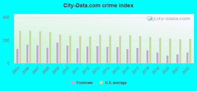
Crime rate in Freetown detailed stats: murders, rapes, robberies, assaults, burglaries, thefts, arson
Full-time law enforcement employees in 2021, including police officers: 21 (20 officers - 19 male; 1 female).
| Officers per 1,000 residents here: | 2.09 |
| Massachusetts average: | 2.53 |
 Recent articles from our blog. Our writers, many of them Ph.D. graduates or candidates, create easy-to-read articles on a wide variety of topics.
Ancestries: Portuguese (32.1%), English (17.4%), French (16.8%), Irish (13.4%), French Canadian (9.9%), Polish (7.4%).
Current Local Time: EST time zone
Incorporated in 1683
Land area: 36.6 square miles.
Population density: 242 people per square mile (very low).
549 residents are foreign born (4.5% Europe, 0.8% Asia).
| This town: | 6.5% |
| Massachusetts: | 12.2% |
| Freetown town: | 1.2% ($1,926) |
| Massachusetts: | 1.3% ($2,336) |
Nearest city with pop. 50,000+: Fall River, MA  (8.1 miles , pop. 91,938).
Nearest city with pop. 200,000+: Boston, MA (38.1 miles , pop. 589,141).
Nearest city with pop. 1,000,000+: Bronx, NY (161.1 miles , pop. 1,332,650).
Nearest cities:
), ), )Latitude: 41.77 N, Longitude: 71.03 W
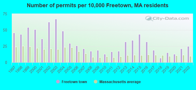
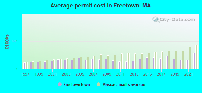
Single-family new house construction building permits:
- 2022: 21 buildings, average cost: $287,600
- 2021: 18 buildings, average cost: $159,400
- 2020: 11 buildings, average cost: $173,900
- 2019: 13 buildings, average cost: $185,200
- 2018: 6 buildings, average cost: $233,100
- 2017: 16 buildings, average cost: $194,400
- 2016: 27 buildings, average cost: $207,600
- 2015: 37 buildings, average cost: $211,900
- 2014: 29 buildings, average cost: $189,100
- 2013: 27 buildings, average cost: $151,600
- 2012: 15 buildings, average cost: $139,500
- 2011: 14 buildings, average cost: $139,500
- 2010: 11 buildings, average cost: $156,300
- 2009: 16 buildings, average cost: $182,700
- 2008: 15 buildings, average cost: $175,800
- 2007: 18 buildings, average cost: $189,000
- 2006: 22 buildings, average cost: $170,900
- 2005: 25 buildings, average cost: $197,100
- 2004: 41 buildings, average cost: $170,600
- 2003: 57 buildings, average cost: $171,400
- 2002: 53 buildings, average cost: $175,100
- 2001: 31 buildings, average cost: $144,900
- 2000: 43 buildings, average cost: $140,000
- 1999: 46 buildings, average cost: $126,500
- 1998: 37 buildings, average cost: $127,700
- 1997: 39 buildings, average cost: $124,300
| Here: | 3.6% |
| Massachusetts: | 3.5% |
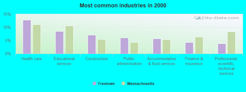
- Health care (12.8%)
- Educational services (8.5%)
- Construction (7.1%)
- Public administration (6.0%)
- Accommodation & food services (5.6%)
- Finance & insurance (4.3%)
- Professional, scientific, technical services (3.8%)
- Construction (13.4%)
- Public administration (8.2%)
- Repair & maintenance (4.8%)
- Health care (4.6%)
- Accommodation & food services (4.1%)
- Truck transportation (3.5%)
- Finance & insurance (3.2%)
- Health care (20.9%)
- Educational services (14.1%)
- Accommodation & food services (7.2%)
- Finance & insurance (5.4%)
- Professional, scientific, technical services (5.1%)
- Public administration (3.9%)
- Social assistance (3.5%)
- Other production occupations, including supervisors (4.4%)
- Other management occupations, except farmers and farm managers (4.3%)
- Retail sales workers, except cashiers (3.9%)
- Other sales and related occupations, including supervisors (3.5%)
- Registered nurses (3.3%)
- Preschool, kindergarten, elementary, and middle school teachers (3.2%)
- Secretaries and administrative assistants (2.9%)
- Other production occupations, including supervisors (6.3%)
- Electrical equipment mechanics and other installation, maintenance, and repair workers, including supervisors (5.5%)
- Engineers (4.8%)
- Other management occupations, except farmers and farm managers (4.5%)
- Retail sales workers, except cashiers (4.2%)
- Metal workers and plastic workers (4.0%)
- Other sales and related occupations, including supervisors (3.6%)
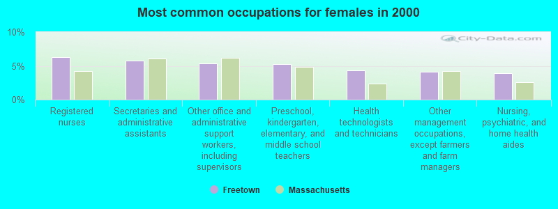
- Registered nurses (6.3%)
- Secretaries and administrative assistants (5.8%)
- Other office and administrative support workers, including supervisors (5.4%)
- Preschool, kindergarten, elementary, and middle school teachers (5.3%)
- Health technologists and technicians (4.4%)
- Other management occupations, except farmers and farm managers (4.1%)
- Nursing, psychiatric, and home health aides (3.9%)
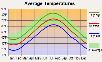
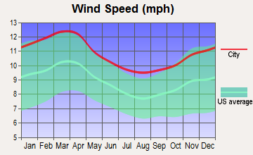
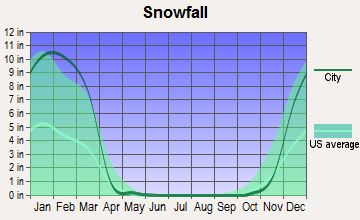
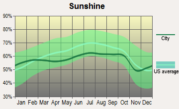
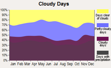
Average climate in Freetown, Massachusetts
Based on data reported by over 4,000 weather stations
(lower is better)
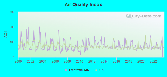
Air Quality Index (AQI) level in 2022 was 65.8. This is about average.
| City: | 65.8 |
| U.S.: | 72.6 |
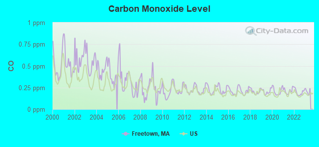
Carbon Monoxide (CO) [ppm] level in 2022 was 0.196. This is better than average. Closest monitor was 17.8 miles away from the city center.
| City: | 0.196 |
| U.S.: | 0.251 |
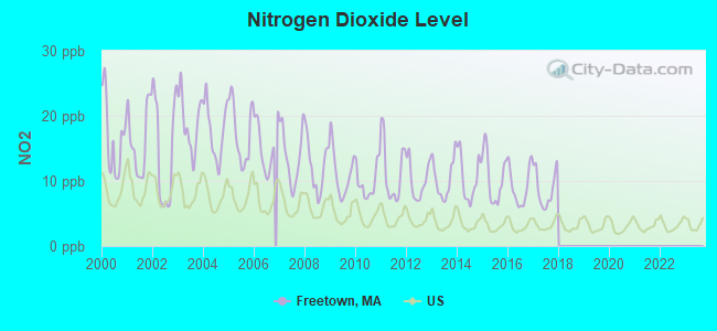
Nitrogen Dioxide (NO2) [ppb] level in 2017 was 8.78. This is significantly worse than average. Closest monitor was 7.9 miles away from the city center.
| City: | 8.78 |
| U.S.: | 5.11 |
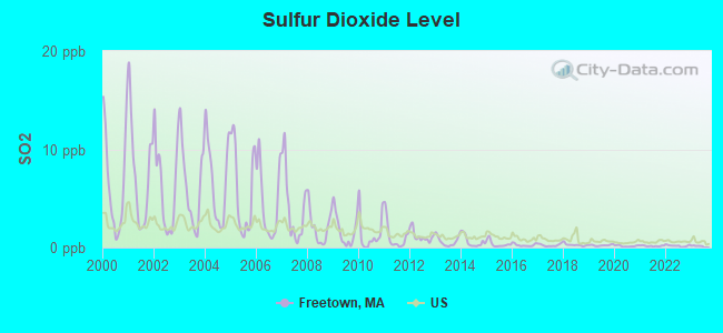
Sulfur Dioxide (SO2) [ppb] level in 2022 was 0.179. This is significantly better than average. Closest monitor was 5.5 miles away from the city center.
| City: | 0.179 |
| U.S.: | 1.515 |
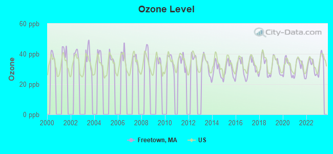
Ozone [ppb] level in 2022 was 31.2. This is about average. Closest monitor was 9.5 miles away from the city center.
| City: | 31.2 |
| U.S.: | 33.3 |
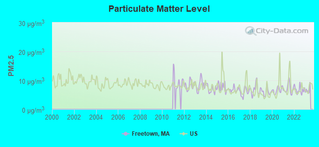
Particulate Matter (PM2.5) [µg/m3] level in 2022 was 6.75. This is better than average. Closest monitor was 9.5 miles away from the city center.
| City: | 6.75 |
| U.S.: | 8.11 |
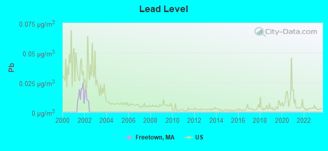
Lead (Pb) [µg/m3] level in 2001 was 0.0155. This is significantly worse than average. Closest monitor was 7.9 miles away from the city center.
| City: | 0.0155 |
| U.S.: | 0.0093 |
Tornado activity:
Freetown-area historical tornado activity is below Massachusetts state average. It is 64% smaller than the overall U.S. average.
On 6/9/1953, a category F3 (max. wind speeds 158-206 mph) tornado 21.1 miles away from the Freetown town center injured 17 people and caused between $500,000 and $5,000,000 in damages.
On 6/9/1953, a category F4 (max. wind speeds 207-260 mph) tornado 44.4 miles away from the town center killed 90 people and injured 1228 people and caused between $50,000,000 and $500,000,000 in damages.
Earthquake activity:
Freetown-area historical earthquake activity is significantly above Massachusetts state average. It is 75% smaller than the overall U.S. average.On 10/7/1983 at 10:18:46, a magnitude 5.3 (5.1 MB, 5.3 LG, 5.1 ML, Class: Moderate, Intensity: VI - VII) earthquake occurred 225.8 miles away from Freetown center
On 4/20/2002 at 10:50:47, a magnitude 5.3 (5.3 ML, Depth: 3.0 mi) earthquake occurred 232.5 miles away from Freetown center
On 1/19/1982 at 00:14:42, a magnitude 4.7 (4.5 MB, 4.7 MD, 4.5 LG, Class: Light, Intensity: IV - V) earthquake occurred 123.0 miles away from the city center
On 10/16/2012 at 23:12:25, a magnitude 4.7 (4.7 ML, Depth: 10.0 mi) earthquake occurred 127.6 miles away from the city center
On 4/20/2002 at 10:50:47, a magnitude 5.2 (5.2 MB, 4.2 MS, 5.2 MW, 5.0 MW) earthquake occurred 231.7 miles away from the city center
On 8/22/1992 at 12:20:32, a magnitude 4.8 (4.8 MB, 3.8 MS, 4.7 LG, Depth: 6.2 mi) earthquake occurred 188.2 miles away from Freetown center
Magnitude types: regional Lg-wave magnitude (LG), body-wave magnitude (MB), duration magnitude (MD), local magnitude (ML), surface-wave magnitude (MS), moment magnitude (MW)
Natural disasters:
The number of natural disasters in Bristol County (23) is greater than the US average (15).Major Disasters (Presidential) Declared: 12
Emergencies Declared: 11
Causes of natural disasters: Floods: 8, Hurricanes: 7, Storms: 5, Snows: 3, Snowstorms: 3, Winter Storms: 3, Blizzards: 2, Explosion: 1, Heavy Rain: 1, Snowfall: 1, Tropical Storm: 1, Wind: 1 (Note: some incidents may be assigned to more than one category).
Hospitals and medical centers near Freetown:
- SARAH BRAYTON NURSING CARE CTR (Nursing Home, about 5 miles away; FALL RIVER, MA)
- SASSAQUIN NURSING HOME, INC (Nursing Home, about 5 miles away; NEW BEDFORD, MA)
- SOUTHEAST MASS HEALTH AND REHABILITATION CENTER (Nursing Home, about 5 miles away; NEW BEDFORD, MA)
- OAKS, THE (Nursing Home, about 5 miles away; NEW BEDFORD, MA)
- NEW BEDFORD REHABILITATION HOSPITAL (Hospital, about 5 miles away; NEW BEDFORD, MA)
- PARKWOOD HOSPITAL , INC (Hospital, about 5 miles away; NEW BEDFORD, MA)
- CATHOLIC MEMORIAL HOME (Nursing Home, about 6 miles away; FALL RIVER, MA)
Colleges/universities with over 2000 students nearest to Freetown:
- Bristol Community College (about 6 miles; Fall River, MA; Full-time enrollment: 5,707)
- University of Massachusetts-Dartmouth (about 11 miles; North Dartmouth, MA; FT enrollment: 7,545)
- Roger Williams University (about 15 miles; Bristol, RI; FT enrollment: 4,375)
- Bridgewater State University (about 16 miles; Bridgewater, MA; FT enrollment: 9,802)
- Brown University (about 20 miles; Providence, RI; FT enrollment: 8,458)
- Rhode Island School of Design (about 20 miles; Providence, RI; FT enrollment: 2,714)
- Stonehill College (about 21 miles; Easton, MA; FT enrollment: 2,563)
Public elementary/middle school in Freetown:
- FREETOWN ELEMENTARY SCHOOL (Students: 546, Location: 43 BULLOCK ROAD, Grades: PK-3)
Points of interest:
Notable locations in Freetown: Camp Welch (A), Freetown Fire Department Station 2 (B), Freetown Fire Department Station 3 Headquarters (C). Display/hide their locations on the map
Church in Freetown: Saint Bernards Church (A). Display/hide its location on the map
Cemeteries: Old Quaker Cemetery (1), Lawton Cemetery (2), Assonet Burying Ground (3), Winslow Cemetery (4), Richmond Cemetery (5), White Cemetery (6), Chace Cemetery (7). Display/hide their locations on the map
Lakes, reservoirs, and swamps: Twinings Pond (A), Betty Spring (B), Assonet River Reservoir (C), Terry Brook Pond (D), Forge Pond (E), Cedar Swamp (F), Bolton Cedar Swamp (G). Display/hide their locations on the map
Streams, rivers, and creeks: Fall Brook (A), Ashley Brook (B), Rattlesnake Brook (C), Quaker Brook (D), Mother Brook (E). Display/hide their locations on the map
Park in Freetown: Cathedral Camp (1). Display/hide its location on the map
Birthplace of: Marcus Morton - Politician, Nathaniel B. Borden - Politician, Richard Borden - Manufacturing businesspeople, Simeon Borden - Civil engineer.
| This town: | 2.8 people |
| Massachusetts: | 2.5 people |
| This town: | 80.1% |
| Whole state: | 63.0% |
| This town: | 6.5% |
| Whole state: | 7.0% |
Likely homosexual households (counted as self-reported same-sex unmarried-partner households)
- Lesbian couples: 0.5% of all households
- Gay men: 0.4% of all households
| This town: | 5.0% |
| Whole state: | 9.3% |
| This town: | 2.5% |
| Whole state: | 4.4% |
People in group quarters in Freetown in 2010:
- 48 people in residential schools for people with disabilities
- 24 people in residential treatment centers for juveniles (non-correctional)
- 10 people in correctional facilities intended for juveniles
- 8 people in group homes intended for adults
- 2 people in other noninstitutional facilities
40 people in homes for abused, dependent, and neglected children in 2000
For population 15 years and over in Freetown:
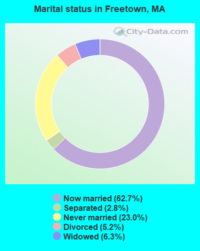
- Never married: 23.0%
- Now married: 62.7%
- Separated: 2.8%
- Widowed: 6.3%
- Divorced: 5.2%
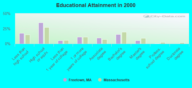
For population 25 years and over in Freetown:
- High school or higher: 82.4%
- Bachelor's degree or higher: 21.7%
- Graduate or professional degree: 6.3%
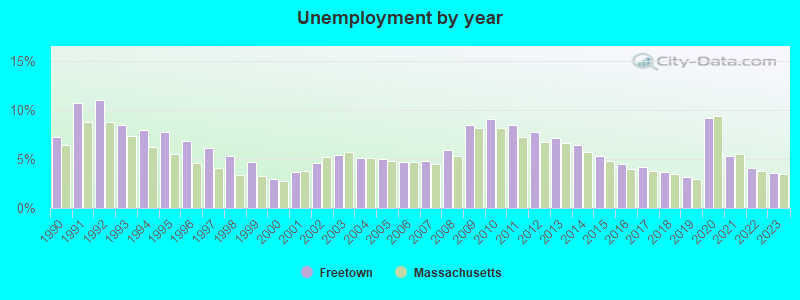
- Unemployed: 2.1%
- Mean travel time to work (commute): 26.7 minutes
| Here: | 12.7 |
| Massachusetts average: | 13.1 |
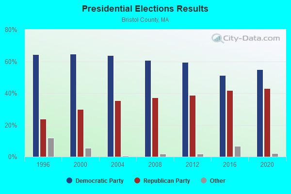
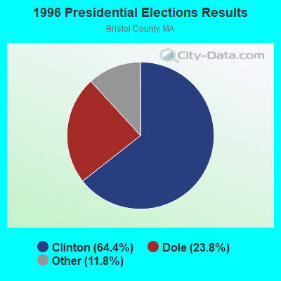
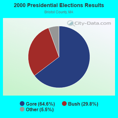
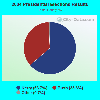
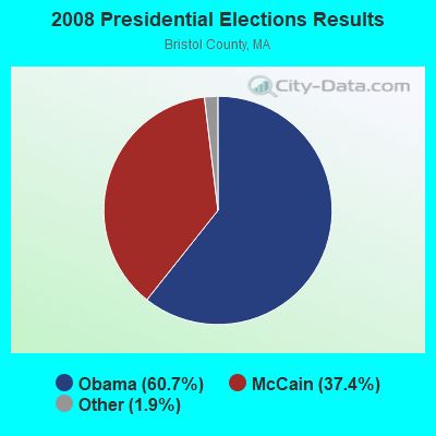
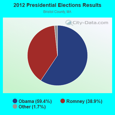
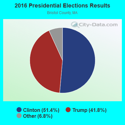
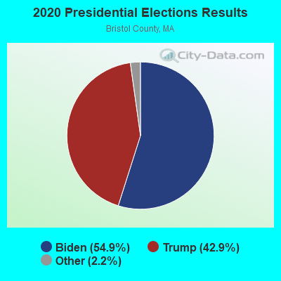
Graphs represent county-level data. Detailed 2008 Election Results
Religion statistics for Freetown, MA (based on Bristol County data)
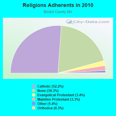
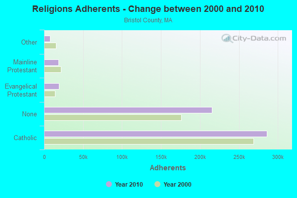
| Religion | Adherents | Congregations |
|---|---|---|
| Catholic | 286,113 | 72 |
| Evangelical Protestant | 18,765 | 128 |
| Mainline Protestant | 18,246 | 83 |
| Other | 7,807 | 33 |
| Orthodox | 1,565 | 4 |
| Black Protestant | 511 | 5 |
| None | 215,278 | - |
Food Environment Statistics:
| Bristol County: | 2.00 / 10,000 pop. |
| Massachusetts: | 1.98 / 10,000 pop. |
| This county: | 0.09 / 10,000 pop. |
| State: | 0.05 / 10,000 pop. |
| Bristol County: | 1.93 / 10,000 pop. |
| Massachusetts: | 2.22 / 10,000 pop. |
| Bristol County: | 2.35 / 10,000 pop. |
| State: | 1.77 / 10,000 pop. |
| Bristol County: | 8.20 / 10,000 pop. |
| State: | 8.76 / 10,000 pop. |
| Bristol County: | 9.5% |
| State: | 8.1% |
| Bristol County: | 26.9% |
| Massachusetts: | 22.5% |
| Bristol County: | 14.4% |
| State: | 16.5% |
4.76% of this county's 2021 resident taxpayers lived in other counties in 2020 ($70,162 average adjusted gross income)
| Here: | 4.76% |
| Massachusetts average: | 6.35% |
0.01% of residents moved from foreign countries ($64 average AGI)
Bristol County: 0.01% Massachusetts average: 0.01%
Top counties from which taxpayers relocated into this county between 2020 and 2021:
| from Plymouth County, MA | |
| from Norfolk County, MA | |
| from Providence County, RI |
4.63% of this county's 2020 resident taxpayers moved to other counties in 2021 ($72,404 average adjusted gross income)
| Here: | 4.63% |
| Massachusetts average: | 7.18% |
0.01% of residents moved to foreign countries ($83 average AGI)
Bristol County: 0.01% Massachusetts average: 0.02%
Top counties to which taxpayers relocated from this county between 2020 and 2021:
| to Plymouth County, MA | |
| to Providence County, RI | |
| to Norfolk County, MA |
Strongest AM radio stations in Freetown:
- WALE (990 AM; 50 kW; GREENVILLE, RI; Owner: NORTH AMERICAN BROADCASTING CO., INC.)
- WSAR (1480 AM; 5 kW; FALL RIVER, MA; Owner: BRISTOL COUNTY BROADCASTING, INC.)
- WEEI (850 AM; 50 kW; BOSTON, MA; Owner: ENTERCOM BOSTON LICENSE, LLC)
- WBZ (1030 AM; 50 kW; BOSTON, MA; Owner: INFINITY BROADCASTING OPERATIONS, INC.)
- WBSM (1420 AM; 5 kW; NEW BEDFORD, MA; Owner: CITADEL BROADCASTING COMPANY)
- WPRO (630 AM; 5 kW; PROVIDENCE, RI; Owner: CITADEL BROADCASTING COMPANY)
- WRKO (680 AM; 50 kW; BOSTON, MA; Owner: ENTERCOM BOSTON LICENSE, LLC)
- WKOX (1200 AM; 50 kW; FRAMINGHAM, MA; Owner: CAPSTAR TX LIMITED PARTNERSHIP)
- WBIX (1060 AM; 40 kW; NATICK, MA; Owner: LANGER BROADCASTING CORPORATION)
- WHJJ (920 AM; 5 kW; PROVIDENCE, RI)
- WSKO (790 AM; 5 kW; PROVIDENCE, RI; Owner: CITADEL BROADCASTING COMPANY)
- WAMG (890 AM; 25 kW; DEDHAM, MA; Owner: MEGA COMMUNICATIONS OF DEDHAM LICENSEE, LLC)
- WCRN (830 AM; 50 kW; WORCESTER, MA; Owner: CARTER BROADCASTING CORPORATION)
Strongest FM radio stations in Freetown:
- WWBB (101.5 FM; PROVIDENCE, RI; Owner: CLEAR CHANNEL BROADCASTING LICENSES, INC.)
- WCTK (98.1 FM; NEW BEDFORD, MA; Owner: HALL COMMUNICATIONS, INC.)
- WJFD-FM (97.3 FM; NEW BEDFORD, MA; Owner: EDMUND DINIS, TRUSTEE)
- WSNE-FM (93.3 FM; TAUNTON, MA; Owner: CAPSTAR TX LIMITED PARTNERSHIP)
- WFHN (107.1 FM; FAIRHAVEN, MA; Owner: CITADEL BROADCASTING COMPANY)
- WSMU-FM (91.1 FM; NORTH DARTMOUTH, MA; Owner: UNIVERSITY OF MASSACHUSETTS)
- WKKB (100.3 FM; MIDDLETOWN, RI; Owner: CITADEL BROADCASTING COMPANY)
- WBRU (95.5 FM; PROVIDENCE, RI; Owner: BROWN BROADCASTING SERVICE, INC.)
- WHJY (94.1 FM; PROVIDENCE, RI; Owner: CAPSTAR TX LIMITED PARTNERSHIP)
- WBOT (97.7 FM; BROCKTON, MA; Owner: RADIO ONE LICENSES, LLC)
- WBMX (98.5 FM; BOSTON, MA; Owner: INFINITY RADIO OPERATIONS INC.)
- WBOS (92.9 FM; BROOKLINE, MA; Owner: GREATER BOSTON RADIO, INC.)
- WJMN (94.5 FM; BOSTON, MA; Owner: AMFM RADIO LICENSES, L.L.C.)
- WCRB (102.5 FM; WALTHAM, MA; Owner: CHARLES RIVER BROADCASTING WCRB LICE)
- WTKK (96.9 FM; BOSTON, MA; Owner: GREATER BOSTON RADIO, INC.)
- WROR-FM (105.7 FM; FRAMINGHAM, MA; Owner: GREATER BOSTON RADIO, INC.)
- WXKS-FM (107.9 FM; MEDFORD, MA; Owner: AMFM RADIO LICENSES, L.L.C.)
- WMJX (106.7 FM; BOSTON, MA; Owner: GREATER BOSTON RADIO, INC.)
- WPRO-FM (92.3 FM; PROVIDENCE, RI; Owner: CITADEL BROADCASTING COMPANY)
- WGBH (89.7 FM; BOSTON, MA; Owner: WGBH EDUCATIONAL FOUNDATION)
TV broadcast stations around Freetown:
- WLWC (Channel 28; NEW BEDFORD, MA; Owner: C-28 FCC LICENSEE SUBSIDIARY, LLC)
- WLNE-TV (Channel 6; NEW BEDFORD, MA; Owner: FREEDOM BROADCASTING OF SOUTHERN NEW ENGLAND, INC.)
- WPRI-TV (Channel 12; PROVIDENCE, RI; Owner: TVL BROADCASTING OF RHODE ISLAND, LLC)
- WNAC-TV (Channel 64; PROVIDENCE, RI; Owner: WNAC, LLC)
- WJAR (Channel 10; PROVIDENCE, RI; Owner: OUTLET BROADCASTING, INC.)
- WWDP (Channel 46; NORWELL, MA; Owner: NORWELL TELEVISION, LLC)
- WSBE-TV (Channel 36; PROVIDENCE, RI; Owner: RHODE ISLAND PUBLIC TELECOM. AUTHORITY)
- WCVB-TV (Channel 5; BOSTON, MA; Owner: WCVB HEARST-ARGYLE TV, INC.)
- WGBH-TV (Channel 2; BOSTON, MA; Owner: WGBH EDUCATIONAL FOUNDATION)
- WPXQ (Channel 69; BLOCK ISLAND, RI; Owner: OCEAN STATE TELEVISION, L.L.C.)
- WHDH-TV (Channel 7; BOSTON, MA; Owner: WHDH-TV)
- WMFP (Channel 62; LAWRENCE, MA; Owner: WSAH LICENSE, INC.)
- WSBK-TV (Channel 38; BOSTON, MA; Owner: VIACOM INC.)
- WLVI-TV (Channel 56; CAMBRIDGE, MA; Owner: WLVI, INC.)
- WBZ-TV (Channel 4; BOSTON, MA; Owner: VIACOM INC.)
- WGBX-TV (Channel 44; BOSTON, MA; Owner: WGBH EDUCATIONAL FOUNDATION)
- WFXT (Channel 25; BOSTON, MA; Owner: FOX TELEVISION STATIONS INC.)
- WBPX (Channel 68; BOSTON, MA; Owner: PAXSON BOSTON-68 LICENSE, INC.)
- WUTF (Channel 66; MARLBOROUGH, MA; Owner: TELEFUTURA BOSTON LLC)
- W40BO (Channel 40; BOSTON, MA; Owner: PAXSON COMMUNICATIONS LPTV, INC.)
- WTMU-LP (Channel 32; BOSTON, MA; Owner: ZGS BOSTON, INC.)
- WCEA-LP (Channel 58; BOSTON, MA; Owner: CHANNEL 19 TV CORPORATION)
- WRIW-LP (Channel 50; PROVIDENCE, RI; Owner: ZGS PROVIDENCE, INC.)
Medal of Honor Recipients
Medal of Honor Recipient born in Freetown: John M. Deane.
- National Bridge Inventory (NBI) Statistics
- 15Number of bridges
- 151ft / 45.5mTotal length
- $40,795,000Total costs
- 220,715Total average daily traffic
- 12,020Total average daily truck traffic
- 326,127Total future (year 21) average daily traffic
- New bridges - historical statistics
- 2Before 1900
- 11940-1949
- 71950-1959
- 21960-1969
- 11980-1989
- 22010-2019
FCC Registered Antenna Towers:
12 (See the full list of FCC Registered Antenna Towers in Freetown)FCC Registered Broadcast Land Mobile Towers:
1- Lat: 41.771667 Lon: -71.010306, Call Sign: WRPR940,
Assigned Frequencies: 452.268 MHz, 457.268 MHz, Grant Date: 03/10/2022, Expiration Date: 03/10/2032, Certifier: Charlie Montelongo, Registrant: Master Meter Inc., 101 Regency Parkway, Mansfield, TX 76063-5093, Phone: (817) 842-8000, Fax: (817) 842-8030, Email:
FCC Registered Microwave Towers:
3- FREETOWN S MAIN, 165 South Main Street (Lat: 41.772694 Lon: -71.095056), Type: Pole, Structure height: 43.3 m, Overall height: 44.8 m, Call Sign: WPVU993,
Assigned Frequencies: 10603.1 MHz, Grant Date: 08/26/2002, Expiration Date: 08/26/2012, Cancellation Date: 09/10/2002, Certifier: Kellye E Abernathy, Registrant: Cingular Wireless LLC, 17330 Preston Road, Suite 100a, Dallas, TX 75252, Phone: (972) 733-2025, Fax: (972) 733-5924
- ITW, 107 Braley Road (Lat: 41.754306 Lon: -70.965306), Type: Gtower, Structure height: 91.4 m, Overall height: 96 m, Call Sign: WRVS824,
Assigned Frequencies: 10775.0 MHz, Grant Date: 01/03/2023, Expiration Date: 01/03/2033, Certifier: Carlton E Abbott, Jr., Registrant: Langone & Associates, 87 Emerald Court, Tewksbury, MA 01876, Phone: (508) 633-2470, Email:
- PD, 15 Memorial Drive (Lat: 41.762917 Lon: -71.012833), Type: Ltower, Structure height: 54.9 m, Call Sign: WRVS825,
Assigned Frequencies: 11255.0 MHz, 11265.0 MHz, Grant Date: 01/03/2023, Expiration Date: 01/03/2033, Certifier: Carlton E Abbott, Jr., Registrant: Langone & Associates, 87 Emerald Court, Tewksbury, MA 01876, Phone: (508) 633-2470, Email:
FCC Registered Amateur Radio Licenses:
1- Call Sign: N1ZQZ, Licensee ID: L01312561, Grant Date: 05/24/2017, Expiration Date: 08/20/2027, Certifier: Vincent T Doliveira, Registrant: Vincent T Doliveira, 44 Huron Ave, Freetown, MA 02717
- 78.0%Fuel oil, kerosene, etc.
- 9.4%Bottled, tank, or LP gas
- 7.3%Utility gas
- 2.7%Electricity
- 1.3%Wood
- 1.0%Coal or coke
- 0.3%No fuel used
- 63.2%Fuel oil, kerosene, etc.
- 18.6%Bottled, tank, or LP gas
- 8.8%Utility gas
- 6.9%Electricity
- 2.5%Wood
Freetown compared to Massachusetts state average:
- Unemployed percentage significantly below state average.
- Black race population percentage significantly below state average.
- Hispanic race population percentage significantly below state average.
- Foreign-born population percentage significantly below state average.
- Renting percentage significantly below state average.
- Length of stay since moving in significantly above state average.
- Number of rooms per house significantly below state average.
- House age significantly below state average.
- Percentage of population with a bachelor's degree or higher below state average.
Freetown on our top lists:
- #5 on the list of "Top 101 cities with largest percentage of females in occupations: bus drivers (population 5,000+)"
- #8 on the list of "Top 101 cities with largest percentage of females in industries: music stores (population 5,000+)"
- #18 on the list of "Top 101 cities with largest percentage of females in industries: other transportation, and support activities, and couriers (population 5,000+)"
- #24 on the list of "Top 101 cities with largest percentage of males in industries: clothing and accessories, including shoe, stores (population 5,000+)"
- #26 on the list of "Top 101 cities with largest percentage of males in industries: leather and allied products (population 5,000+)"
- #36 on the list of "Top 101 cities with largest percentage of males in industries: recyclable material merchant wholesalers (population 5,000+)"
- #37 on the list of "Top 101 cities with largest percentage of males in industries: groceries and related products merchant wholesalers (population 5,000+)"
- #40 on the list of "Top 101 cities with largest percentage of males in industries: apparel (population 5,000+)"
- #41 on the list of "Top 101 cities with largest percentage of females in industries: vending machine operators (population 5,000+)"
- #42 on the list of "Top 101 cities with largest percentage of females in occupations: other health diagnosing and treating practitioners and technical occupations (population 5,000+)"
- #47 on the list of "Top 101 cities with largest percentage of males in industries: u. s. postal service (population 5,000+)"
- #51 on the list of "Top 101 cities with largest percentage of males in occupations: bus drivers (population 5,000+)"
- #51 on the list of "Top 101 cities with the largest percentage of people in homes for abused, dependent, and neglected children (population 1,000+)"
- #53 on the list of "Top 101 cities with largest percentage of males in occupations: printing workers (population 5,000+)"
- #53 on the list of "Top 101 cities with largest percentage of males in industries: retail florists (population 5,000+)"
- #74 on the list of "Top 101 cities with largest percentage of females in occupations: transportation, tourism, and lodging attendants (population 5,000+)"
- #75 on the list of "Top 101 cities with largest percentage of females in occupations: other food preparation and serving workers including supervisors (population 5,000+)"
- #75 on the list of "Top 101 cities with largest percentage of females in industries: fuel dealers (population 5,000+)"
- #79 on the list of "Top 101 cities with largest percentage of males in industries: textile mills and textile products (population 5,000+)"
- #90 on the list of "Top 101 cities with largest percentage of males in industries: alcoholic beverages merchant wholesalers (population 5,000+)"
- #50 (02702) on the list of "Top 101 zip codes with the largest percentage of Portuguese first ancestries"
- #14 on the list of "Top 101 counties with the lowest percentage of residents that keep firearms around their homes"
- #29 on the list of "Top 101 counties with the lowest percentage of residents relocating to foreign countries in 2011 (pop. 50,000+)"
- #32 on the list of "Top 101 counties with the most Catholic congregations"
- #34 on the list of "Top 101 counties with the highest percentage of residents that smoked 100+ cigarettes in their lives"
- #41 on the list of "Top 101 counties with the most Catholic adherents"

|
Total of 7 patent applications in 2008-2024.