Bridge Statistics for Wawarsing, New York (NY)
Condition, Traffic, Stress, Structural Evaluation, Project Costs
- National Bridge Inventory (NBI) Statistics
- 33Number of bridges
- 377ft / 115mTotal length
- $101,576,000Total costs
- 70,421Total average daily traffic
- 5,065Total average daily truck traffic
- National Bridge Inventory (NBI) Registered Bridges for Wawarsing
- No street view available for this location
- New bridges - historical statistics
- 1Before 1900
- 11910-1919
- 21920-1929
- 41930-1939
- 51950-1959
- 41960-1969
- 31970-1979
- 11980-1989
- 71990-1999
- 32000-2009
- 22010-2019
- Reconstructed bridges - Historical Statistics
- 11960-1969
- 01970-1979
- 61980-1989
- 31990-1999
- 12000-2009
- 12010-2019
- Bridge Condition - Deck
- 7.1%Excellent
- 25.0%Good
- 46.4%Satisfactory
- 17.9%Fair
- 3.6%Poor
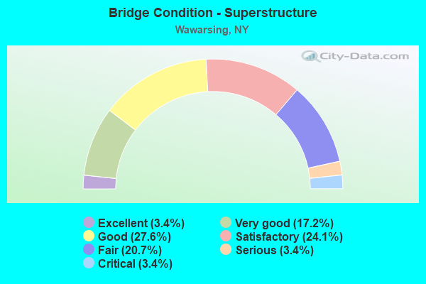
- Bridge Condition - Superstructure
- 3.4%Excellent
- 17.2%Very good
- 27.6%Good
- 24.1%Satisfactory
- 20.7%Fair
- 3.4%Serious
- 3.4%Critical
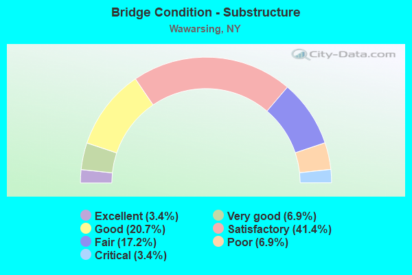
- Bridge Condition - Substructure
- 3.4%Excellent
- 6.9%Very good
- 20.7%Good
- 41.4%Satisfactory
- 17.2%Fair
- 6.9%Poor
- 3.4%Critical
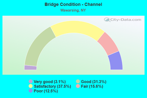
- Bridge Condition - Channel
- 3.1%Very good
- 31.3%Good
- 37.5%Satisfactory
- 15.6%Fair
- 12.5%Poor
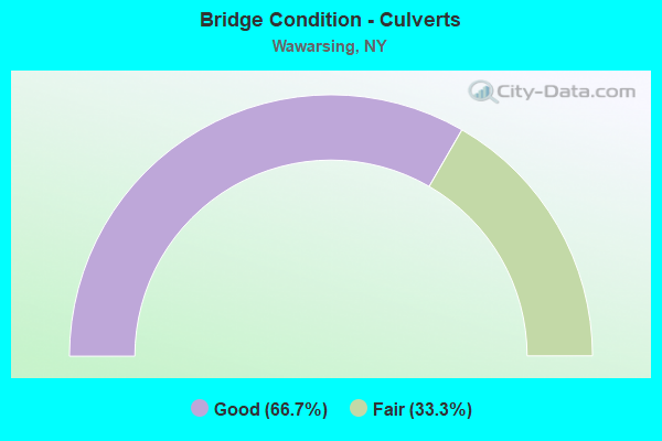
- Bridge Condition - Culverts
- 66.7%Good
- 33.3%Fair
Find on map >> Show street view
Structure Number: 102541, Location: JCT RTE 44+RONDOUT CR (Lat: 41.770100, Lng: -74.311361), Route carried "on" structure: US 44, Year Built: 1957, Year Reconstructed: 1987, Status: Open, Structure Length: 8.08m (26.51ft), Average Daily Traffic: 3,177 (year 2019), Truck Traffic: 7%, Average Future Daily Traffic: 3,191 (year 2040), Design Load: HS 20, Features Intersected: RONDOUT CREEK
Minimum Vertical Clearance: 30+ m (98+ ft), Kilometerpoint: 0.225, Lanes on structure: 2, Base Highway Network: Yes, Owner: State Highway Agency, Approaching Roadway Width: 11.6m (38.1ft), Skew: 2 degrees, Material/Design: Steel, Design/Construction: Stringer/Multi-beam, Number Of Spans In Main Unit: 3, Length of Maximum Span: 26.5m (86.9ft), Curb-To-Curb Width: 11.4m (37.4ft), Out-to-Out Width: 12.0m (39.4ft)
Condition: Deck: Satisfactory, Superstructure: Good, Substructure: Poor, Channel: Satisfactory, Operating Rating: 80.7 metric tons, Method Used To Determine Operating Rating: Load Factor (LF), Inventory Rating: 48.1 metric tons, Method Used To Determine Inventory Rating: Load Factor (LF), Structural Evaluation: Meets minimum limits, Deck Geometry: Somewhat better than minimum adequacy, Waterway Adequacy: Somewhat better than minimum adequacy, Approach Roadway Alignment: Equal to present desirable criteria, Length Of Structure Improvement: 8.07m (26.48ft), Designated Inspection Frequency: Every 24 months, Inspection Date: May 2021, Bridge Improvement Cost: $3,646,000, Roadway Improvement Cost: $2,135,000, Total Project Cost: $5,780,000 ( Estimate for 2021), Deck Structure Type: Concrete Cast-file-Place, Wearing Surface/Protective System: Wearing Surface: Integral Concrete, Deck Protection: Epoxy Coated Reinforcing
Find on map >> Show street view
Structure Number: 102542, Location: 0.6 MI E JCT RTS 44+209 (Lat: 41.767494, Lng: -74.303372), Route carried "on" structure: US 44, Year Built: 1957, Year Reconstructed: 1969, Status: Open, Structure Length: 0.85m (2.79ft), Average Daily Traffic: 3,177 (year 2019), Truck Traffic: 7%, Average Future Daily Traffic: 3,191 (year 2040), Design Load: H 20, Features Intersected: KERHONKSON RESERVOIR OUT
Minimum Vertical Clearance: 30+ m (98+ ft), Kilometerpoint: 0.981, Lanes on structure: 2, Base Highway Network: Yes, Owner: State Highway Agency, Approaching Roadway Width: 12.2m (40.0ft), Material/Design: Concrete, Design/Construction: Frame, Number Of Spans In Main Unit: 2, Length of Maximum Span: 3.6m (11.8ft), Curb-To-Curb Width: 13.4m (44.0ft), Out-to-Out Width: 19.2m (63.0ft)
Condition: Superstructure: Fair, Substructure: Fair, Channel: Satisfactory, Structural Evaluation: Somewhat better than minimum adequacy, Deck Geometry: Better than present minimum criteria, Waterway Adequacy: Meets minimum limits, Approach Roadway Alignment: Equal to present desirable criteria, Length Of Structure Improvement: 0.85m (2.79ft), Designated Inspection Frequency: Every 24 months, Inspection Date: May 2021, Bridge Improvement Cost: $956,000, Roadway Improvement Cost: $560,000, Total Project Cost: $1,516,000 ( Estimate for 2021)
Find on map >> Show street view
Structure Number: 102543, Location: 0.8 MI E JCT RTS 44+209 (Lat: 41.766633, Lng: -74.299728), Route carried "on" structure: US 44, Year Built: 1957, Status: Open, Structure Length: 0.73m (2.40ft), Average Daily Traffic: 3,177 (year 2019), Truck Traffic: 7%, Average Future Daily Traffic: 3,191 (year 2040), Design Load: H 20, Features Intersected: KERHONKSON RES IN
Minimum Vertical Clearance: 30+ m (98+ ft), Kilometerpoint: 1.303, Lanes on structure: 2, Base Highway Network: Yes, Owner: State Highway Agency, Approaching Roadway Width: 11.6m (38.1ft), Skew: 1 degrees, Material/Design: Concrete continuous, Design/Construction: Culvert, Number Of Spans In Main Unit: 2, Length of Maximum Span: 3.0m (9.8ft)
Condition: Channel: Poor, Culverts: Fair, Inventory Rating: 60.8 metric tons, Method Used To Determine Inventory Rating: Load Factor (LF), Structural Evaluation: Somewhat better than minimum adequacy, Waterway Adequacy: Meets minimum limits, Approach Roadway Alignment: Equal to present desirable criteria, Length Of Structure Improvement: 0.73m (2.40ft), Designated Inspection Frequency: Every 24 months, Inspection Date: August 2021, Bridge Improvement Cost: $444,000, Roadway Improvement Cost: $260,000, Total Project Cost: $705,000 ( Estimate for 2021)
Find on map >> Show street view
Structure Number: 102544, Location: 2.9 MI E JCT RTS 44 & 209 (Lat: 41.745725, Lng: -74.281206), Route carried "on" structure: US 44, Year Built: 1997, Status: Open, Structure Length: 1.16m (3.81ft), Average Daily Traffic: 3,177 (year 2019), Truck Traffic: 7%, Average Future Daily Traffic: 3,191 (year 2040), Design Load: HS 25 or greater, Features Intersected: STONY KILL
Minimum Vertical Clearance: 30+ m (98+ ft), Kilometerpoint: 4.650, Lanes on structure: 2, Base Highway Network: Yes, Owner: State Highway Agency, Approaching Roadway Width: 12.8m (42.0ft), Skew: 1 degrees, Material/Design: Concrete, Design/Construction: Frame, Number Of Spans In Main Unit: 1, Length of Maximum Span: 10.6m (34.8ft), Curb-To-Curb Width: 12.2m (40.0ft), Out-to-Out Width: 12.8m (42.0ft)
Condition: Deck: Good, Superstructure: Good, Substructure: Good, Channel: Satisfactory, Operating Rating: 63.5 metric tons, Method Used To Determine Operating Rating: Load Factor (LF), Inventory Rating: 38.1 metric tons, Method Used To Determine Inventory Rating: Load Factor (LF), Structural Evaluation: Better than present minimum criteria, Deck Geometry: Equal to present minimum criteria, Waterway Adequacy: Somewhat better than minimum adequacy, Approach Roadway Alignment: Equal to present desirable criteria, Length Of Structure Improvement: 1.15m (3.77ft), Designated Inspection Frequency: Every 24 months, Inspection Date: April 2021, Bridge Improvement Cost: $1,055,000, Roadway Improvement Cost: $618,000, Total Project Cost: $1,673,000 ( Estimate for 2021)
Find on map >> Show street view
Structure Number: 102659, Location: 5.2 MI W JCT SH 52 + US 2 (Lat: 41.726703, Lng: -74.487675), Route carried "on" structure: State highway 52, Year Built: 1950, Year Reconstructed: 1992, Status: Open, Structure Length: 6.19m (20.31ft), Average Daily Traffic: 3,869 (year 2020), Truck Traffic: 10%, Average Future Daily Traffic: 3,905 (year 2040), Design Load: HS 20, Features Intersected: WEST BRANCH BEER KILL
Minimum Vertical Clearance: 30+ m (98+ ft), Kilometerpoint: 7.176, Lanes on structure: 2, Base Highway Network: Yes, Owner: State Highway Agency, Approaching Roadway Width: 12.2m (40.0ft), Skew: 1 degrees, Material/Design: Steel continuous, Design/Construction: Stringer/Multi-beam, Number Of Spans In Main Unit: 3, Length of Maximum Span: 21.9m (71.9ft), Curb-To-Curb Width: 12.2m (40.0ft), Out-to-Out Width: 12.8m (42.0ft)
Condition: Deck: Good, Superstructure: Very good, Substructure: Satisfactory, Channel: Good, Operating Rating: 56.2 metric tons, Method Used To Determine Operating Rating: Load Factor (LF), Inventory Rating: 33.6 metric tons, Method Used To Determine Inventory Rating: Load Factor (LF), Structural Evaluation: Equal to present minimum criteria, Deck Geometry: Equal to present minimum criteria, Waterway Adequacy: Somewhat better than minimum adequacy, Approach Roadway Alignment: Equal to present desirable criteria, Length Of Structure Improvement: 6.18m (20.28ft), Designated Inspection Frequency: Every 24 months, Inspection Date: October 2020, Bridge Improvement Cost: $4,335,000, Roadway Improvement Cost: $2,538,000, Total Project Cost: $6,873,000 ( Estimate for 2021), Deck Structure Type: Concrete Cast-file-Place, Wearing Surface/Protective System: Wearing Surface: Bituminous, Membrane: Other, Deck Protection: Epoxy Coated Reinforcing
Find on map >> Show street view
Structure Number: 10266, Location: 1.3 MI W JCT SH 52 & US 2 (Lat: 41.725617, Lng: -74.415228), Route carried "on" structure: State highway 52, Year Built: 1998, Status: Open, Structure Length: 2.90m (9.51ft), Average Daily Traffic: 3,869 (year 2020), Truck Traffic: 10%, Average Future Daily Traffic: 3,887 (year 2040), Design Load: HS 25 or greater, Features Intersected: N. OLD GREENFIELD RD - C
Minimum Vertical Clearance: 30+ m (98+ ft), Kilometerpoint: 13.403, Lanes on structure: 2, Lanes under structure: 2, Base Highway Network: Yes, Owner: State Highway Agency, Approaching Roadway Width: 12.2m (40.0ft), Material/Design: Prestressed concrete, Design/Construction: Box Beam or Girders - Multiple, Number Of Spans In Main Unit: 1, Length of Maximum Span: 28.0m (91.9ft), Curb-To-Curb Width: 12.2m (40.0ft), Out-to-Out Width: 13.2m (43.3ft)
Condition: Deck: Satisfactory, Superstructure: Satisfactory, Substructure: Fair, Channel: Good, Operating Rating: 70.6 metric tons, Method Used To Determine Operating Rating: Load and Resistance Factor Rating (LRFR) rating reported by rating factor(RF) method using HL-93 loadings, Inventory Rating: 54.4 metric tons, Method Used To Determine Inventory Rating: Load and Resistance Factor Rating (LRFR) rating reported by rating factor(RF) method using HL-93 loadings, Structural Evaluation: Somewhat better than minimum adequacy, Deck Geometry: Equal to present minimum criteria, Underclear: High priority of corrective action, Waterway Adequacy: Somewhat better than minimum adequacy, Approach Roadway Alignment: Equal to present desirable criteria, Length Of Structure Improvement: 2.89m (9.48ft), Designated Inspection Frequency: Every 24 months, Inspection Date: September 2020, Bridge Improvement Cost: $1,389,000, Roadway Improvement Cost: $813,000, Total Project Cost: $2,202,000 ( Estimate for 2021), Deck Structure Type: Concrete Cast-file-Place, Wearing Surface/Protective System: Wearing Surface: Bituminous, Deck Protection: Epoxy Coated Reinforcing
Find on map >> Show street view
Structure Number: 102663, Location: 1.8 MI E JCT SH 52 & US 2 (Lat: 41.694164, Lng: -74.392658), Route carried "on" structure: State highway 52, Year Built: 1991, Status: Open, Structure Length: 13.14m (43.11ft), Average Daily Traffic: 2,513 (year 2014), Truck Traffic: 7%, Average Future Daily Traffic: 3,052 (year 2040), Design Load: HS 20+Mod, Features Intersected: SOUTH GULLY CREEK
Minimum Vertical Clearance: 30+ m (98+ ft), Kilometerpoint: 18.407, Lanes on structure: 2, Base Highway Network: Yes, Owner: State Highway Agency, Approaching Roadway Width: 12.2m (40.0ft), Material/Design: Steel continuous, Design/Construction: Stringer/Multi-beam, Number Of Spans In Main Unit: 3, Length of Maximum Span: 49.0m (160.8ft), Curb-To-Curb Width: 12.2m (40.0ft), Out-to-Out Width: 13.0m (42.7ft)
Condition: Deck: Satisfactory, Superstructure: Good, Substructure: Satisfactory, Channel: Good, Operating Rating: 55.7 metric tons, Method Used To Determine Operating Rating: Load and Resistance Factor Rating (LRFR) rating reported by rating factor(RF) method using HL-93 loadings, Inventory Rating: 43.4 metric tons, Method Used To Determine Inventory Rating: Load and Resistance Factor Rating (LRFR) rating reported by rating factor(RF) method using HL-93 loadings, Structural Evaluation: Equal to present minimum criteria, Deck Geometry: Equal to present minimum criteria, Waterway Adequacy: Equal to present minimum criteria, Approach Roadway Alignment: Equal to present desirable criteria, Length Of Structure Improvement: 13.13m (43.08ft), Designated Inspection Frequency: Every 24 months, Inspection Date: August 2020, Bridge Improvement Cost: $6,398,000, Roadway Improvement Cost: $3,747,000, Total Project Cost: $10,145,000 ( Estimate for 2021), Deck Structure Type: Concrete Cast-file-Place, Wearing Surface/Protective System: Wearing Surface: Integral Concrete, Deck Protection: Epoxy Coated Reinforcing
Find on map >> Show street view
Structure Number: 102708, Location: 5.4 MI W JCT RTS 55+209 (Lat: 41.791769, Lng: -74.414072), Route carried "on" structure: State highway 55, Year Built: 1939, Year Reconstructed: 2010, Status: Open, Structure Length: 9.81m (32.19ft), Average Daily Traffic: 785 (year 2011), Truck Traffic: 8%, Average Future Daily Traffic: 818 (year 2040), Design Load: H 20, Features Intersected: RONDOUT CREEK
Minimum Vertical Clearance: 4.57m (14.99ft), Kilometerpoint: 8.302, Lanes on structure: 2, Base Highway Network: Yes, Owner: State Highway Agency, Approaching Roadway Width: 7.9m (25.9ft), Skew: 5 degrees, Material/Design: Steel, Design/Construction: Truss - Thru, Number Of Spans In Main Unit: 1, Number Of Approach Spans: 2, Length of Maximum Span: 54.8m (179.8ft), Curb-To-Curb Width: 7.9m (25.9ft), Out-to-Out Width: 8.8m (28.9ft)
Condition: Deck: Satisfactory, Superstructure: Satisfactory, Substructure: Good, Channel: Good, Operating Rating: 58.1 metric tons, Method Used To Determine Operating Rating: Load Factor (LF), Inventory Rating: 34.5 metric tons, Method Used To Determine Inventory Rating: Load Factor (LF), Structural Evaluation: Equal to present minimum criteria, Deck Geometry: Somewhat better than minimum adequacy, Waterway Adequacy: Equal to present minimum criteria, Approach Roadway Alignment: Meets minimum limits, Length Of Structure Improvement: 9.81m (32.19ft), Designated Inspection Frequency: Every 24 months, Critical Feature Inspection Frequency: Every 24 months, Inspection Date: June 2021, Critical Feature Inspection Date: June 2021, Bridge Improvement Cost: $6,714,000, Roadway Improvement Cost: $3,932,000, Total Project Cost: $10,646,000 ( Estimate for 2021), Deck Structure Type: Concrete Cast-file-Place, Wearing Surface/Protective System: Wearing Surface: Integral Concrete, Deck Protection: Epoxy Coated Reinforcing
Find on map >> Show street view
Structure Number: 102709, Location: 1.8 MI W JCT RTS 55+209 (Lat: 41.757475, Lng: -74.381128), Route carried "on" structure: State highway 55, Year Built: 2017, Status: Open, Structure Length: 5.00m (16.40ft), Average Daily Traffic: 1,917 (year 2019), Truck Traffic: 7%, Average Future Daily Traffic: 2,371 (year 2040), Design Load: HL 93, Features Intersected: RONDOUT CREEK
Minimum Vertical Clearance: 30+ m (98+ ft), Kilometerpoint: 14.143, Lanes on structure: 2, Base Highway Network: Yes, Owner: State Highway Agency, Approaching Roadway Width: 11.6m (38.1ft), Material/Design: Steel, Design/Construction: Stringer/Multi-beam, Number Of Spans In Main Unit: 1, Length of Maximum Span: 48.2m (158.1ft), Curb-To-Curb Width: 11.6m (38.1ft), Out-to-Out Width: 12.5m (41.0ft)
Condition: Deck: Excellent, Superstructure: Excellent, Substructure: Excellent, Channel: Very good, Operating Rating: 65.1 metric tons, Method Used To Determine Operating Rating: Load and Resistance Factor Rating (LRFR) rating reported by rating factor(RF) method using HL-93 loadings, Inventory Rating: 50.2 metric tons, Method Used To Determine Inventory Rating: Load and Resistance Factor Rating (LRFR) rating reported by rating factor(RF) method using HL-93 loadings, Structural Evaluation: Superior to present desirable criteria, Deck Geometry: Equal to present minimum criteria, Waterway Adequacy: Equal to present desirable criteria, Approach Roadway Alignment: Equal to present desirable criteria, Length Of Structure Improvement: 4.99m (16.37ft), Designated Inspection Frequency: Every 24 months, Inspection Date: July 2020, Bridge Improvement Cost: $2,850,000, Roadway Improvement Cost: $1,669,000, Total Project Cost: $4,519,000 ( Estimate for 2021), Deck Structure Type: Concrete Cast-file-Place, Wearing Surface/Protective System: Wearing Surface: Integral Concrete, Deck Protection: Epoxy Coated Reinforcing
Find on map >> Show street view
Structure Number: 10271, Location: 0.9 MI W JCT RTS 55+209 (Lat: 41.746125, Lng: -74.384247), Route carried "on" structure: State highway 55, Year Built: 1969, Year Reconstructed: 2014, Status: Open, Structure Length: 4.08m (13.39ft), Average Daily Traffic: 1,917 (year 2019), Truck Traffic: 7%, Average Future Daily Traffic: 2,371 (year 2040), Design Load: H 20, Features Intersected: RONDOUT CREEK
Minimum Vertical Clearance: 30+ m (98+ ft), Kilometerpoint: 15.639, Lanes on structure: 2, Base Highway Network: Yes, Owner: State Highway Agency, Approaching Roadway Width: 10.1m (33.1ft), Material/Design: Steel, Design/Construction: Stringer/Multi-beam, Number Of Spans In Main Unit: 1, Length of Maximum Span: 39.3m (128.9ft), Curb-To-Curb Width: 9.9m (32.5ft), Out-to-Out Width: 10.9m (35.8ft)
Condition: Deck: Excellent, Superstructure: Good, Substructure: Good, Channel: Good, Operating Rating: 54.4 metric tons, Method Used To Determine Operating Rating: Load and Resistance Factor Rating (LRFR) rating reported by rating factor(RF) method using HL-93 loadings, Inventory Rating: 42.1 metric tons, Method Used To Determine Inventory Rating: Load and Resistance Factor Rating (LRFR) rating reported by rating factor(RF) method using HL-93 loadings, Structural Evaluation: Better than present minimum criteria, Deck Geometry: Somewhat better than minimum adequacy, Waterway Adequacy: Superior to present desirable criteria, Approach Roadway Alignment: Equal to present desirable criteria, Length Of Structure Improvement: 4.08m (13.39ft), Designated Inspection Frequency: Every 24 months, Inspection Date: September 2020, Bridge Improvement Cost: $2,498,000, Roadway Improvement Cost: $1,463,000, Total Project Cost: $3,960,000 ( Estimate for 2021), Deck Structure Type: Concrete Cast-file-Place, Wearing Surface/Protective System: Wearing Surface: Monolithic Concrete, Deck Protection: Epoxy Coated Reinforcing
Find on map >> Show street view
Structure Number: 102711, Location: 1.6 MI N JCT RTS 209+55 (Lat: 41.757544, Lng: -74.358728), Route carried "on" structure: US 209, Year Built: 1933, Year Reconstructed: 1994, Status: Open, Structure Length: 3.57m (11.71ft), Average Daily Traffic: 9,022 (year 2019), Truck Traffic: 7%, Average Future Daily Traffic: 9,064 (year 2040), Design Load: HS 25 or greater, Features Intersected: VER NOOY KILL
Minimum Vertical Clearance: 30+ m (98+ ft), Kilometerpoint: 13.049, Lanes on structure: 2, Base Highway Network: Yes, Owner: State Highway Agency, Approaching Roadway Width: 11.0m (36.1ft), Skew: 2 degrees, Material/Design: Steel, Design/Construction: Stringer/Multi-beam, Number Of Spans In Main Unit: 1, Length of Maximum Span: 33.5m (109.9ft), Curb or Sidewalk Widths: Left: 0.0m, Right: 1.8m (5.9ft), Curb-To-Curb Width: 11.0m (36.1ft), Out-to-Out Width: 13.1m (43.0ft)
Condition: Deck: Good, Superstructure: Good, Substructure: Good, Channel: Good, Inventory Rating: 79.8 metric tons, Method Used To Determine Inventory Rating: Load Factor (LF), Structural Evaluation: Better than present minimum criteria, Deck Geometry: Meets minimum limits, Waterway Adequacy: Superior to present desirable criteria, Approach Roadway Alignment: Meets minimum limits, Length Of Structure Improvement: 3.56m (11.68ft), Designated Inspection Frequency: Every 24 months, Inspection Date: December 2020, Bridge Improvement Cost: $2,435,000, Roadway Improvement Cost: $1,426,000, Total Project Cost: $3,861,000 ( Estimate for 2021), Deck Structure Type: Concrete Cast-file-Place, Wearing Surface/Protective System: Wearing Surface: Integral Concrete, Deck Protection: Epoxy Coated Reinforcing
Find on map >> Show street view
Structure Number: 104071, Location: 4.5 MI S JCT RTS 209+52 (Lat: 41.661806, Lng: -74.425281), Route carried "on" structure: US 209, Year Built: 1961, Status: Open, Structure Length: 3.26m (10.70ft), Average Daily Traffic: 4,887 (year 2018), Truck Traffic: 7%, Average Future Daily Traffic: 4,909 (year 2040), Design Load: HS 20, Features Intersected: HOMOWACK KILL
Minimum Vertical Clearance: 30+ m (98+ ft), Kilometerpoint: 0.113, Lanes on structure: 2, Base Highway Network: Yes, Owner: State Highway Agency, Approaching Roadway Width: 12.2m (40.0ft), Skew: 5 degrees, Material/Design: Steel, Design/Construction: Stringer/Multi-beam, Number Of Spans In Main Unit: 1, Length of Maximum Span: 30.4m (99.7ft), Curb-To-Curb Width: 8.5m (27.9ft), Out-to-Out Width: 10.1m (33.1ft)
Condition: Deck: Fair, Superstructure: Fair, Substructure: Satisfactory, Channel: Satisfactory, Operating Rating: 73.5 metric tons, Method Used To Determine Operating Rating: Load Factor (LF), Inventory Rating: 43.5 metric tons, Method Used To Determine Inventory Rating: Load Factor (LF), Structural Evaluation: Somewhat better than minimum adequacy, Deck Geometry: Meets minimum limits, Waterway Adequacy: Meets minimum limits, Approach Roadway Alignment: Equal to present desirable criteria, Length Of Structure Improvement: 3.26m (10.70ft), Designated Inspection Frequency: Every 24 months, Inspection Date: June 2021, Bridge Improvement Cost: $1,739,000, Roadway Improvement Cost: $1,018,000, Total Project Cost: $2,757,000 ( Estimate for 2021), Deck Structure Type: Concrete Cast-file-Place, Wearing Surface/Protective System: Wearing Surface: Bituminous
Find on map >> Show street view
Structure Number: 104072, Location: 1.7 MI S JCT RTS 209 + 52 (Lat: 41.696497, Lng: -74.409711), Route carried "on" structure: US 209, Year Built: 1993, Status: Open, Structure Length: 0.91m (2.99ft), Average Daily Traffic: 4,887 (year 2018), Truck Traffic: 7%, Average Future Daily Traffic: 4,909 (year 2040), Design Load: HS 25 or greater, Features Intersected: LEUREN KILL
Minimum Vertical Clearance: 30+ m (98+ ft), Kilometerpoint: 4.618, Lanes on structure: 2, Base Highway Network: Yes, Owner: State Highway Agency, Approaching Roadway Width: 12.2m (40.0ft), Skew: 3 degrees, Material/Design: Concrete, Design/Construction: Culvert, Number Of Spans In Main Unit: 1, Length of Maximum Span: 8.8m (28.9ft), Curb-To-Curb Width: 12.2m (40.0ft), Out-to-Out Width: 18.1m (59.4ft)
Condition: Channel: Poor, Culverts: Good, Operating Rating: 71.0 metric tons, Method Used To Determine Operating Rating: Load and Resistance Factor Rating (LRFR) rating reported by rating factor(RF) method using HL-93 loadings, Inventory Rating: 54.8 metric tons, Method Used To Determine Inventory Rating: Load and Resistance Factor Rating (LRFR) rating reported by rating factor(RF) method using HL-93 loadings, Structural Evaluation: Better than present minimum criteria, Deck Geometry: Equal to present minimum criteria, Waterway Adequacy: Meets minimum limits, Approach Roadway Alignment: Equal to present desirable criteria, Length Of Structure Improvement: 0.91m (2.99ft), Designated Inspection Frequency: Every 24 months, Inspection Date: September 2021, Bridge Improvement Cost: $935,000, Roadway Improvement Cost: $548,000, Total Project Cost: $1,483,000 ( Estimate for 2021)
Find on map >> Show street view
Structure Number: 104074, Location: JCT RTE 209 & ROUNDOUT CR (Lat: 41.738208, Lng: -74.376794), Route carried "on" structure: US 209, Year Built: 1991, Status: Open, Structure Length: 4.63m (15.19ft), Average Daily Traffic: 11,922 (year 2011), Truck Traffic: 7%, Average Future Daily Traffic: 11,978 (year 2040), Design Load: HS 20, Features Intersected: RONDOUT CREEK
Minimum Vertical Clearance: 30+ m (98+ ft), Kilometerpoint: 10.249, Lanes on structure: 3, Base Highway Network: Yes, Owner: State Highway Agency, Approaching Roadway Width: 14.0m (45.9ft), Material/Design: Steel, Design/Construction: Stringer/Multi-beam, Number Of Spans In Main Unit: 1, Length of Maximum Span: 45.1m (148.0ft), Curb or Sidewalk Widths: Left: 1.5m (4.9ft), Right: 0.0m, Curb-To-Curb Width: 14.0m (45.9ft), Out-to-Out Width: 16.2m (53.1ft)
Condition: Deck: Satisfactory, Superstructure: Very good, Substructure: Satisfactory, Channel: Satisfactory, Operating Rating: 95.6 metric tons, Method Used To Determine Operating Rating: Load and Resistance Factor Rating (LRFR) rating reported by rating factor(RF) method using HL-93 loadings, Inventory Rating: 73.9 metric tons, Method Used To Determine Inventory Rating: Load and Resistance Factor Rating (LRFR) rating reported by rating factor(RF) method using HL-93 loadings, Structural Evaluation: Equal to present minimum criteria, Deck Geometry: Somewhat better than minimum adequacy, Waterway Adequacy: Somewhat better than minimum adequacy, Approach Roadway Alignment: Equal to present desirable criteria, Length Of Structure Improvement: 4.63m (15.19ft), Designated Inspection Frequency: Every 24 months, Inspection Date: December 2020, Bridge Improvement Cost: $3,651,000, Roadway Improvement Cost: $2,138,000, Total Project Cost: $5,788,000 ( Estimate for 2021), Deck Structure Type: Concrete Cast-file-Place, Wearing Surface/Protective System: Wearing Surface: Integral Concrete, Deck Protection: Epoxy Coated Reinforcing
Find on map >> Show street view
Structure Number: 109134, Location: 4.3 MI S JCT RTS 209+52 (Lat: 41.665617, Lng: -74.424939), Route carried "on" structure: US 209, Year Built: 1961, Status: Open, Structure Length: 2.74m (8.99ft), Average Daily Traffic: 4,887 (year 2018), Truck Traffic: 7%, Average Future Daily Traffic: 4,909 (year 2040), Design Load: HS 20, Features Intersected: SANDBURG CREEK
Minimum Vertical Clearance: 30+ m (98+ ft), Kilometerpoint: 0.547, Lanes on structure: 2, Base Highway Network: Yes, Owner: State Highway Agency, Approaching Roadway Width: 11.6m (38.1ft), Skew: 1 degrees, Material/Design: Steel, Design/Construction: Stringer/Multi-beam, Number Of Spans In Main Unit: 1, Length of Maximum Span: 25.6m (84.0ft), Curb or Sidewalk Widths: Left: 0.5m (1.6ft), Right: 0.5m (1.6ft), Curb-To-Curb Width: 9.8m (32.2ft), Out-to-Out Width: 11.3m (37.1ft)
Condition: Deck: Satisfactory, Superstructure: Satisfactory, Substructure: Satisfactory, Channel: Fair, Operating Rating: 21.7 metric tons, Method Used To Determine Operating Rating: Load and Resistance Factor Rating (LRFR) rating reported by rating factor(RF) method using HL-93 loadings, Inventory Rating: 16.8 metric tons, Method Used To Determine Inventory Rating: Load and Resistance Factor Rating (LRFR) rating reported by rating factor(RF) method using HL-93 loadings, Structural Evaluation: Meets minimum limits, Deck Geometry: Meets minimum limits, Waterway Adequacy: Meets minimum limits, Approach Roadway Alignment: Equal to present desirable criteria, Length Of Structure Improvement: 2.74m (8.99ft), Designated Inspection Frequency: Every 24 months, Inspection Date: August 2021, Bridge Improvement Cost: $1,694,000, Roadway Improvement Cost: $992,000, Total Project Cost: $2,686,000 ( Estimate for 2021), Deck Structure Type: Concrete Cast-file-Place, Wearing Surface/Protective System: Wearing Surface: Bituminous
Find on map >> Show street view
Structure Number: 202723, Location: 3.4 MI NW OF LACKAWACK (Lat: 41.822756, Lng: -74.453822), Route carried "on" structure: Other road 55A, Year Built: 2000, Status: Open, Structure Length: 6.77m (22.21ft), Average Daily Traffic: 697 (year 2016), Truck Traffic: 3%, Average Future Daily Traffic: 976 (year 2036), Features Intersected: TROUT CREEK
Minimum Vertical Clearance: 30+ m (98+ ft), Kilometerpoint: 3.186, Lanes on structure: 2, Base Highway Network: Yes, Owner: Local Agency, Approaching Roadway Width: 9.8m (32.2ft), Material/Design: Steel continuous, Design/Construction: Stringer/Multi-beam, Number Of Spans In Main Unit: 2, Length of Maximum Span: 36.5m (119.8ft), Curb-To-Curb Width: 9.8m (32.2ft), Out-to-Out Width: 10.7m (35.1ft)
Condition: Deck: Good, Superstructure: Very good, Substructure: Very good, Channel: Good, Inventory Rating: 59.9 metric tons, Method Used To Determine Inventory Rating: Load Factor (LF), Structural Evaluation: Equal to present desirable criteria, Deck Geometry: Equal to present minimum criteria, Waterway Adequacy: Somewhat better than minimum adequacy, Approach Roadway Alignment: Equal to present minimum criteria, Length Of Structure Improvement: 6.76m (22.18ft), Designated Inspection Frequency: Every 24 months, Inspection Date: September 2021, Bridge Improvement Cost: $3,772,000, Roadway Improvement Cost: $2,209,000, Total Project Cost: $5,982,000 ( Estimate for 2021), Deck Structure Type: Concrete Cast-file-Place, Wearing Surface/Protective System: Wearing Surface: Monolithic Concrete, Deck Protection: Epoxy Coated Reinforcing
Find on map >> Show street view
Structure Number: 222476, Location: AT SPRING GLEN (Lat: 41.665808, Lng: -74.429500), Route carried "on" structure: Other road , Year Built: 1988, Status: Open, Structure Length: 2.10m (6.89ft), Average Daily Traffic: 416 (year 2017), Truck Traffic: 8%, Average Future Daily Traffic: 582 (year 2037), Design Load: HS 20, Features Intersected: SANDBURG CREEK, Facility Carried by Structure: OLD ROUTE 209
Minimum Vertical Clearance: 30+ m (98+ ft), Kilometerpoint: 0.579, Lanes on structure: 2, Owner: Town or Township Highway Agency, Approaching Roadway Width: 7.9m (25.9ft), Skew: 2 degrees, Material/Design: Steel, Design/Construction: Stringer/Multi-beam, Number Of Spans In Main Unit: 1, Length of Maximum Span: 19.8m (65.0ft), Curb or Sidewalk Widths: Left: 1.2m (3.9ft), Right: 0.0m, Curb-To-Curb Width: 7.9m (25.9ft), Out-to-Out Width: 9.8m (32.2ft)
Condition: Deck: Good, Superstructure: Satisfactory, Substructure: Satisfactory, Channel: Satisfactory, Operating Rating: 53.8 metric tons, Method Used To Determine Operating Rating: Load and Resistance Factor Rating (LRFR) rating reported by rating factor(RF) method using HL-93 loadings, Inventory Rating: 41.5 metric tons, Method Used To Determine Inventory Rating: Load and Resistance Factor Rating (LRFR) rating reported by rating factor(RF) method using HL-93 loadings, Structural Evaluation: Equal to present minimum criteria, Deck Geometry: Somewhat better than minimum adequacy, Waterway Adequacy: Somewhat better than minimum adequacy, Approach Roadway Alignment: Equal to present desirable criteria, Length Of Structure Improvement: 2.10m (6.89ft), Designated Inspection Frequency: Every 24 months, Inspection Date: April 2021, Bridge Improvement Cost: $1,138,000, Roadway Improvement Cost: $667,000, Total Project Cost: $1,805,000 ( Estimate for 2021), Deck Structure Type: Concrete Cast-file-Place, Wearing Surface/Protective System: Wearing Surface: Bituminous, Membrane: Other, Deck Protection: Epoxy Coated Reinforcing
Find on map >> Show street view
Structure Number: 222479, Location: .7 MI SE OF WAWARSING (Lat: 41.750361, Lng: -74.350189), Route carried "on" structure: Other road , Year Built: 1915, Year Reconstructed: 2001, Status: Closed, Structure Length: 6.10m (20.01ft), Average Daily Traffic: 233 (year 2017), Truck Traffic: 4%, Average Future Daily Traffic: 326 (year 2037), Features Intersected: RONDOUT CREEK, Facility Carried by Structure: PORT BEN ROAD
Minimum Vertical Clearance: 4.06m (13.32ft), Kilometerpoint: 1.062, Lanes on structure: 1, Owner: Town or Township Highway Agency, Approaching Roadway Width: 6.1m (20.0ft), Material/Design: Steel, Design/Construction: Truss - Thru, Number Of Spans In Main Unit: 1, Length of Maximum Span: 60.4m (198.2ft), Curb-To-Curb Width: 5.3m (17.4ft), Out-to-Out Width: 5.6m (18.4ft)
Condition: Deck: Fair, Superstructure: Serious, Substructure: Fair, Channel: Satisfactory, Waterway Adequacy: Equal to present desirable criteria, Approach Roadway Alignment: Somewhat better than minimum adequacy, Bridge Posting: Required (Relationship of Operating Rating to Maximum Legal Load: > 39.9% below), Length Of Structure Improvement: 6.09m (19.98ft), Designated Inspection Frequency: Every 12 months, Critical Feature Inspection Frequency: Every 12 months, Inspection Date: September 2021, Critical Feature Inspection Date: September 2021, Bridge Improvement Cost: $2,475,000, Roadway Improvement Cost: $1,449,000, Total Project Cost: $3,924,000 ( Estimate for 2021), Deck Structure Type: Open Grating, Wearing Surface/Protective System: Wearing Surface: Other
Find on map >> Show street view
Structure Number: 226444, Location: 2.7 MI NE OF DAIRYLAND (Lat: 41.759700, Lng: -74.490339), Route carried "on" structure: Other road , Year Built: 1979, Status: Open, Structure Length: 1.13m (3.71ft), Average Daily Traffic: 127 (year 2017), Truck Traffic: 8%, Average Future Daily Traffic: 178 (year 2037), Features Intersected: BEER KILL, Facility Carried by Structure: GEIGER ROAD
Minimum Vertical Clearance: 30+ m (98+ ft), Kilometerpoint: 1.287, Lanes on structure: 2, Owner: Town or Township Highway Agency, Approaching Roadway Width: 6.1m (20.0ft), Material/Design: Steel, Design/Construction: Stringer/Multi-beam, Number Of Spans In Main Unit: 1, Length of Maximum Span: 10.3m (33.8ft), Curb-To-Curb Width: 8.5m (27.9ft), Out-to-Out Width: 9.1m (29.9ft)
Condition: Deck: Satisfactory, Superstructure: Very good, Substructure: Good, Channel: Satisfactory, Operating Rating: 28.8 metric tons, Method Used To Determine Operating Rating: Load and Resistance Factor Rating (LRFR) rating reported by rating factor(RF) method using HL-93 loadings, Inventory Rating: 22.4 metric tons, Method Used To Determine Inventory Rating: Load and Resistance Factor Rating (LRFR) rating reported by rating factor(RF) method using HL-93 loadings, Structural Evaluation: Equal to present minimum criteria, Deck Geometry: Equal to present minimum criteria, Waterway Adequacy: Somewhat better than minimum adequacy, Approach Roadway Alignment: Equal to present minimum criteria, Length Of Structure Improvement: 1.12m (3.67ft), Designated Inspection Frequency: Every 24 months, Inspection Date: March 2021, Bridge Improvement Cost: $660,000, Roadway Improvement Cost: $387,000, Total Project Cost: $1,047,000 ( Estimate for 2021), Deck Structure Type: Concrete Cast-file-Place, Wearing Surface/Protective System: Wearing Surface: Bituminous
Find on map >> Show street view
Structure Number: 226445, Location: 1.7 MI E OF GREENFIELD PK (Lat: 41.725022, Lng: -74.454142), Route carried "on" structure: Other road , Year Built: 1965, Status: Open, Structure Length: 1.22m (4.00ft), Truck Traffic: 10%, Features Intersected: WEST BRANCH BEER KILL, Facility Carried by Structure: BARBARA ROAD
Minimum Vertical Clearance: 30+ m (98+ ft), Kilometerpoint: 0.000, Lanes on structure: 2, Owner: Town or Township Highway Agency, Approaching Roadway Width: 7.3m (24.0ft), Material/Design: Steel, Design/Construction: Girder and Floorbeam System, Number Of Spans In Main Unit: 1, Length of Maximum Span: 11.2m (36.7ft), Curb-To-Curb Width: 9.1m (29.9ft), Out-to-Out Width: 9.4m (30.8ft)
Condition: Deck: Fair, Superstructure: Fair, Substructure: Fair, Channel: Poor, Operating Rating: 24.0 metric tons, Method Used To Determine Operating Rating: Load and Resistance Factor Rating (LRFR) rating reported by rating factor(RF) method using HL-93 loadings, Inventory Rating: 18.5 metric tons, Method Used To Determine Inventory Rating: Load and Resistance Factor Rating (LRFR) rating reported by rating factor(RF) method using HL-93 loadings, Structural Evaluation: Somewhat better than minimum adequacy, Deck Geometry: Better than present minimum criteria, Waterway Adequacy: Superior to present desirable criteria, Approach Roadway Alignment: High priority of corrective action, Length Of Structure Improvement: 1.21m (3.97ft), Designated Inspection Frequency: Every 24 months, Inspection Date: December 2021, Bridge Improvement Cost: $670,000, Roadway Improvement Cost: $392,000, Total Project Cost: $1,063,000 ( Estimate for 2021), Deck Structure Type: Open Grating, Wearing Surface/Protective System: Wearing Surface: Other
Find on map >> Show street view
Structure Number: 226446, Location: 1.1 MI SW OF KERHONKSON (Lat: 41.760381, Lng: -74.310233), Route carried "on" structure: Other road , Year Built: 1976, Status: Open, Structure Length: 0.98m (3.22ft), Average Daily Traffic: 292 (year 2020), Truck Traffic: 8%, Average Future Daily Traffic: 409 (year 2040), Features Intersected: TRIBUTARY to RONDOUT CRE, Facility Carried by Structure: FORDEMOOR ROAD
Minimum Vertical Clearance: 30+ m (98+ ft), Kilometerpoint: 2.993, Lanes on structure: 2, Owner: Town or Township Highway Agency, Approaching Roadway Width: 6.7m (22.0ft), Material/Design: Steel, Design/Construction: Stringer/Multi-beam, Number Of Spans In Main Unit: 1, Length of Maximum Span: 8.8m (28.9ft), Curb-To-Curb Width: 8.5m (27.9ft), Out-to-Out Width: 9.1m (29.9ft)
Condition: Deck: Good, Superstructure: Satisfactory, Substructure: Satisfactory, Channel: Satisfactory, Operating Rating: 72.6 metric tons, Method Used To Determine Operating Rating: Load Factor (LF), Inventory Rating: 43.5 metric tons, Method Used To Determine Inventory Rating: Load Factor (LF), Structural Evaluation: Equal to present minimum criteria, Deck Geometry: Equal to present minimum criteria, Waterway Adequacy: Superior to present desirable criteria, Approach Roadway Alignment: Equal to present desirable criteria, Length Of Structure Improvement: 0.97m (3.18ft), Designated Inspection Frequency: Every 24 months, Inspection Date: September 2020, Bridge Improvement Cost: $693,000, Roadway Improvement Cost: $406,000, Total Project Cost: $1,098,000 ( Estimate for 2021), Deck Structure Type: Concrete Cast-file-Place, Wearing Surface/Protective System: Wearing Surface: Bituminous
Find on map >> Show street view
Structure Number: 227014, Location: .5 MI JCT Rt.209 & Plank (Lat: 41.744389, Lng: -74.360819), Route carried "on" structure: Other road , Year Built: 1992, Status: Open, Structure Length: 0.70m (2.30ft), Features Intersected: Criminal Creek, Facility Carried by Structure: Berme Road
Minimum Vertical Clearance: 30+ m (98+ ft), Kilometerpoint: 3.475, Lanes on structure: 2, Owner: Town or Township Highway Agency, Approaching Roadway Width: 7.0m (23.0ft), Material/Design: Concrete continuous, Design/Construction: Culvert, Number Of Spans In Main Unit: 2, Length of Maximum Span: 3.4m (11.2ft), Curb-To-Curb Width: 9.2m (30.2ft), Out-to-Out Width: 10.1m (33.1ft)
Condition: Channel: Fair, Culverts: Good, Operating Rating: 74.9 metric tons, Method Used To Determine Operating Rating: Field evaluation and documented engineering judgment, Inventory Rating: 32.7 metric tons, Method Used To Determine Inventory Rating: Field evaluation and documented engineering judgment, Structural Evaluation: Better than present minimum criteria, Deck Geometry: Better than present minimum criteria, Waterway Adequacy: Meets minimum limits, Approach Roadway Alignment: Equal to present desirable criteria, Length Of Structure Improvement: 0.70m (2.30ft), Designated Inspection Frequency: Every 24 months, Inspection Date: June 2020, Bridge Improvement Cost: $374,000, Roadway Improvement Cost: $219,000, Total Project Cost: $592,000 ( Estimate for 2021), Wearing Surface/Protective System: Wearing Surface: Bituminous
Find on map >> Show street view
Structure Number: 334638, Location: 1.8 MI SW OF ELLENVILLE (Lat: 41.689311, Lng: -74.408706), Route carried "on" structure: Other road , Year Built: 1929, Year Reconstructed: 1990, Status: Open, Structure Length: 1.98m (6.50ft), Average Daily Traffic: 40 (year 2017), Truck Traffic: 8%, Average Future Daily Traffic: 56 (year 2037), Design Load: HS 20, Features Intersected: SANDBURG CREEK, Facility Carried by Structure: HANG GLIDER ROAD
Minimum Vertical Clearance: 30+ m (98+ ft), Kilometerpoint: 0.306, Lanes on structure: 2, Owner: County Highway Agency, Approaching Roadway Width: 8.2m (26.9ft), Material/Design: Steel, Design/Construction: Stringer/Multi-beam, Number Of Spans In Main Unit: 1, Length of Maximum Span: 18.5m (60.7ft), Curb-To-Curb Width: 6.4m (21.0ft), Out-to-Out Width: 7.1m (23.3ft)
Condition: Deck: Satisfactory, Superstructure: Satisfactory, Substructure: Critical, Channel: Poor, Operating Rating: 48.9 metric tons, Method Used To Determine Operating Rating: Load and Resistance Factor Rating (LRFR) rating reported by rating factor(RF) method using HL-93 loadings, Inventory Rating: 37.6 metric tons, Method Used To Determine Inventory Rating: Load and Resistance Factor Rating (LRFR) rating reported by rating factor(RF) method using HL-93 loadings, Structural Evaluation: High priority of replacement, Deck Geometry: Somewhat better than minimum adequacy, Waterway Adequacy: Equal to present desirable criteria, Approach Roadway Alignment: Equal to present desirable criteria, Length Of Structure Improvement: 1.98m (6.50ft), Designated Inspection Frequency: Every 24 months, Inspection Date: March 2020, Bridge Improvement Cost: $513,000, Roadway Improvement Cost: $300,000, Total Project Cost: $813,000 ( Estimate for 2021), Deck Structure Type: Wood or Timber, Wearing Surface/Protective System: Wearing Surface: Bituminous, Membrane: Other
Find on map >> Show street view
Structure Number: 334643, Location: 1.9 MI SE JCT RTS 55A&55 (Lat: 41.773242, Lng: -74.400697), Route carried "on" structure: ServiceOther road , Year Built: 1931, Year Reconstructed: 1993, Status: Closed, Structure Length: 3.05m (10.01ft), Average Daily Traffic: 151 (year 2019), Truck Traffic: 8%, Average Future Daily Traffic: 211 (year 2039), Features Intersected: RONDOUT CREEK, Facility Carried by Structure: SPORTSMANS ROAD
Minimum Vertical Clearance: 30+ m (98+ ft), Kilometerpoint: 3.154, Lanes on structure: 2, Owner: County Highway Agency, Approaching Roadway Width: 7.3m (24.0ft), Material/Design: Steel, Design/Construction: Truss - Thru, Number Of Spans In Main Unit: 1, Length of Maximum Span: 29.2m (95.8ft), Curb-To-Curb Width: 5.5m (18.0ft), Out-to-Out Width: 5.8m (19.0ft)
Condition: Deck: Fair, Superstructure: Critical, Substructure: Satisfactory, Channel: Satisfactory, Deck Geometry: High priority of corrective action, Waterway Adequacy: Superior to present desirable criteria, Approach Roadway Alignment: Equal to present desirable criteria, Bridge Posting: Required (Relationship of Operating Rating to Maximum Legal Load: > 39.9% below), Length Of Structure Improvement: 3.04m (9.97ft), Designated Inspection Frequency: Every 12 months, Critical Feature Inspection Frequency: Every 12 months, Inspection Date: June 2021, Critical Feature Inspection Date: June 2021, Bridge Improvement Cost: $1,636,000, Roadway Improvement Cost: $958,000, Total Project Cost: $2,595,000 ( Estimate for 2021), Deck Structure Type: Wood or Timber, Wearing Surface/Protective System: Wearing Surface: Bituminous
Find on map >> Show street view
Structure Number: 334648, Location: AT NAPANOCH (Lat: 41.743242, Lng: -74.366500), Route carried "on" structure: County highway , Year Built: 1934, Year Reconstructed: 1988, Status: Open, Structure Length: 4.21m (13.81ft), Average Daily Traffic: 1,637 (year 2018), Truck Traffic: 6%, Average Future Daily Traffic: 2,292 (year 2038), Design Load: HS 20, Features Intersected: RONDOUT CREEK, Facility Carried by Structure: INSTITUTION ROAD
Minimum Vertical Clearance: 30+ m (98+ ft), Kilometerpoint: 1.094, Lanes on structure: 2, Owner: County Highway Agency, Approaching Roadway Width: 8.5m (27.9ft), Material/Design: Steel, Design/Construction: Girder and Floorbeam System, Number Of Spans In Main Unit: 1, Length of Maximum Span: 40.5m (132.9ft), Curb-To-Curb Width: 8.4m (27.6ft), Out-to-Out Width: 9.8m (32.2ft)
Condition: Deck: Satisfactory, Superstructure: Good, Substructure: Satisfactory, Channel: Fair, Operating Rating: 59.3 metric tons, Method Used To Determine Operating Rating: Load and Resistance Factor Rating (LRFR) rating reported by rating factor(RF) method using HL-93 loadings, Inventory Rating: 45.7 metric tons, Method Used To Determine Inventory Rating: Load and Resistance Factor Rating (LRFR) rating reported by rating factor(RF) method using HL-93 loadings, Structural Evaluation: Equal to present minimum criteria, Deck Geometry: Meets minimum limits, Waterway Adequacy: Meets minimum limits, Approach Roadway Alignment: Equal to present desirable criteria, Length Of Structure Improvement: 4.20m (13.78ft), Designated Inspection Frequency: Every 24 months, Critical Feature Inspection Frequency: Every 24 months, Inspection Date: September 2020, Critical Feature Inspection Date: September 2020, Bridge Improvement Cost: $2,572,000, Roadway Improvement Cost: $1,506,000, Total Project Cost: $4,077,000 ( Estimate for 2021), Deck Structure Type: Concrete Cast-file-Place, Wearing Surface/Protective System: Wearing Surface: Integral Concrete, Deck Protection: Epoxy Coated Reinforcing
Find on map >> Show street view
Structure Number: 334653, Location: 1 MI NE JCT Rts. 44 & 209 (Lat: 41.773064, Lng: -74.297175), Route carried "on" structure: County highway , Year Built: 2011, Status: Open, Structure Length: 5.00m (16.40ft), Average Daily Traffic: 2,344 (year 2019), Truck Traffic: 6%, Average Future Daily Traffic: 3,282 (year 2039), Design Load: HS 25 or greater, Features Intersected: RONDOUT CREEK, Facility Carried by Structure: COUNTY ROAD 77
Minimum Vertical Clearance: 30+ m (98+ ft), Kilometerpoint: 0.209, Lanes on structure: 2, Owner: County Highway Agency, Approaching Roadway Width: 9.1m (29.9ft), Material/Design: Prestressed concrete, Design/Construction: Box Beam or Girders - Multiple, Number Of Spans In Main Unit: 2, Length of Maximum Span: 24.5m (80.4ft), Curb or Sidewalk Widths: Left: 1.6m (5.2ft), Right: 1.6m (5.2ft), Curb-To-Curb Width: 9.1m (29.9ft), Out-to-Out Width: 13.3m (43.6ft)
Condition: Deck: Satisfactory, Superstructure: Good, Substructure: Very good, Channel: Good, Operating Rating: 95.3 metric tons, Method Used To Determine Operating Rating: Load and Resistance Factor Rating (LRFR) rating reported by rating factor(RF) method using HL-93 loadings, Inventory Rating: 73.5 metric tons, Method Used To Determine Inventory Rating: Load and Resistance Factor Rating (LRFR) rating reported by rating factor(RF) method using HL-93 loadings, Structural Evaluation: Better than present minimum criteria, Deck Geometry: Meets minimum limits, Waterway Adequacy: Somewhat better than minimum adequacy, Approach Roadway Alignment: Equal to present desirable criteria, Length Of Structure Improvement: 4.99m (16.37ft), Designated Inspection Frequency: Every 24 months, Inspection Date: April 2021, Bridge Improvement Cost: $2,200,000, Roadway Improvement Cost: $1,288,000, Total Project Cost: $3,488,000 ( Estimate for 2021), Deck Structure Type: Concrete Cast-file-Place, Wearing Surface/Protective System: Wearing Surface: Integral Concrete, Deck Protection: Epoxy Coated Reinforcing
Find on map >> Show street view
Structure Number: 334661, Location: 2 MI NW JCT 55 & 209 (Lat: 41.767483, Lng: -74.371267), Route carried "on" structure: Other road , Year Built: 2009, Status: Open, Structure Length: 1.98m (6.50ft), Average Daily Traffic: 23 (year 2018), Truck Traffic: 4%, Average Future Daily Traffic: 32 (year 2038), Design Load: HS 20, Features Intersected: VERNOOY KILL, Facility Carried by Structure: Cutler Road
Minimum Vertical Clearance: 30+ m (98+ ft), Kilometerpoint: 1.303, Lanes on structure: 2, Owner: County Highway Agency, Approaching Roadway Width: 6.4m (21.0ft), Material/Design: Steel, Design/Construction: Stringer/Multi-beam, Number Of Spans In Main Unit: 1, Length of Maximum Span: 19.5m (64.0ft), Curb-To-Curb Width: 6.4m (21.0ft), Out-to-Out Width: 7.0m (23.0ft)
Condition: Deck: Good, Superstructure: Very good, Substructure: Satisfactory, Channel: Fair, Operating Rating: 77.1 metric tons, Method Used To Determine Operating Rating: Load Factor (LF), Inventory Rating: 46.3 metric tons, Method Used To Determine Inventory Rating: Load Factor (LF), Structural Evaluation: Equal to present minimum criteria, Deck Geometry: Somewhat better than minimum adequacy, Waterway Adequacy: Superior to present desirable criteria, Approach Roadway Alignment: Meets minimum limits, Length Of Structure Improvement: 1.98m (6.50ft), Designated Inspection Frequency: Every 24 months, Inspection Date: October 2020, Bridge Improvement Cost: $656,000, Roadway Improvement Cost: $384,000, Total Project Cost: $1,039,000 ( Estimate for 2021), Deck Structure Type: Concrete Precast Panels, Wearing Surface/Protective System: Wearing Surface: Bituminous
Find on map >> Show street view
Structure Number: 334687, Location: 2.9 MI N OF GREENFIELD PK (Lat: 41.769617, Lng: -74.486467), Route carried "on" structure: County highway , Year Built: 1953, Status: Open, Structure Length: 2.04m (6.69ft), Average Daily Traffic: 175 (year 2015), Truck Traffic: 8%, Average Future Daily Traffic: 245 (year 2035), Design Load: H 20, Features Intersected: BOTSFORD BROOK, Facility Carried by Structure: ULSTER HEIGHTS RD
Minimum Vertical Clearance: 30+ m (98+ ft), Kilometerpoint: 4.602, Lanes on structure: 2, Owner: County Highway Agency, Approaching Roadway Width: 6.7m (22.0ft), Material/Design: Steel, Design/Construction: Stringer/Multi-beam, Number Of Spans In Main Unit: 1, Length of Maximum Span: 18.8m (61.7ft), Curb or Sidewalk Widths: Left: 0.0m, Right: 1.3m (4.3ft), Curb-To-Curb Width: 6.7m (22.0ft), Out-to-Out Width: 9.0m (29.5ft)
Condition: Deck: Poor, Superstructure: Fair, Substructure: Fair, Channel: Good, Operating Rating: 40.8 metric tons, Method Used To Determine Operating Rating: Load Factor (LF), Inventory Rating: 24.5 metric tons, Method Used To Determine Inventory Rating: Load Factor (LF), Structural Evaluation: Somewhat better than minimum adequacy, Deck Geometry: Meets minimum limits, Waterway Adequacy: Somewhat better than minimum adequacy, Approach Roadway Alignment: Somewhat better than minimum adequacy, Length Of Structure Improvement: 2.04m (6.69ft), Designated Inspection Frequency: Every 24 months, Inspection Date: November 2020, Bridge Improvement Cost: $1,383,000, Roadway Improvement Cost: $810,000, Total Project Cost: $2,193,000 ( Estimate for 2021), Deck Structure Type: Concrete Cast-file-Place, Wearing Surface/Protective System: Wearing Surface: Bituminous
Find on map >> Show street view
Structure Number: 334705, Location: 2.9 MI NW OF ELLENVILLE (Lat: 41.744942, Lng: -74.431086), Route carried "on" structure: Other road , Year Built: 2001, Status: Open, Structure Length: 1.71m (5.61ft), Average Daily Traffic: 102 (year 2017), Truck Traffic: 8%, Average Future Daily Traffic: 143 (year 2037), Design Load: HS 20, Features Intersected: BEER KILL, Facility Carried by Structure: MARCUS ROAD
Minimum Vertical Clearance: 30+ m (98+ ft), Kilometerpoint: 1.239, Lanes on structure: 2, Owner: County Highway Agency, Approaching Roadway Width: 7.9m (25.9ft), Skew: 1 degrees, Material/Design: Steel, Design/Construction: Stringer/Multi-beam, Number Of Spans In Main Unit: 1, Length of Maximum Span: 16.7m (54.8ft), Curb-To-Curb Width: 7.9m (25.9ft), Out-to-Out Width: 8.3m (27.2ft)
Condition: Deck: Fair, Superstructure: Fair, Substructure: Satisfactory, Channel: Satisfactory, Operating Rating: 48.0 metric tons, Method Used To Determine Operating Rating: Load and Resistance Factor Rating (LRFR) rating reported by rating factor(RF) method using HL-93 loadings, Inventory Rating: 36.9 metric tons, Method Used To Determine Inventory Rating: Load and Resistance Factor Rating (LRFR) rating reported by rating factor(RF) method using HL-93 loadings, Structural Evaluation: Somewhat better than minimum adequacy, Deck Geometry: Somewhat better than minimum adequacy, Waterway Adequacy: Somewhat better than minimum adequacy, Approach Roadway Alignment: Equal to present desirable criteria, Length Of Structure Improvement: 1.70m (5.58ft), Designated Inspection Frequency: Every 24 months, Inspection Date: April 2021, Bridge Improvement Cost: $788,000, Roadway Improvement Cost: $461,000, Total Project Cost: $1,250,000 ( Estimate for 2021), Deck Structure Type: Corrugated Steel, Wearing Surface/Protective System: Wearing Surface: Bituminous, Membrane: Other
Find on map >> Show street view
Structure Number: 334723, Location: 1.4 MI E OF WAWARSING (Lat: 41.763028, Lng: -74.333556), Route carried "on" structure: Other road , Year Built: 1896, Year Reconstructed: 1994, Status: Open, Structure Length: 5.27m (17.29ft), Average Daily Traffic: 292 (year 2020), Truck Traffic: 8%, Average Future Daily Traffic: 409 (year 2040), Design Load: HS 25 or greater, Features Intersected: RONDOUT CREEK, Facility Carried by Structure: FOORDMORE RD
Minimum Vertical Clearance: 30+ m (98+ ft), Kilometerpoint: 0.756, Lanes on structure: 2, Owner: County Highway Agency, Approaching Roadway Width: 6.4m (21.0ft), Material/Design: Steel, Design/Construction: Stringer/Multi-beam, Number Of Spans In Main Unit: 2, Length of Maximum Span: 26.2m (86.0ft), Curb-To-Curb Width: 6.4m (21.0ft), Out-to-Out Width: 6.6m (21.7ft)
Condition: Deck: Satisfactory, Superstructure: Fair, Substructure: Good, Channel: Fair, Inventory Rating: 59.9 metric tons, Method Used To Determine Inventory Rating: Load Factor (LF), Structural Evaluation: Somewhat better than minimum adequacy, Deck Geometry: Meets minimum limits, Waterway Adequacy: Meets minimum limits, Approach Roadway Alignment: Equal to present minimum criteria, Length Of Structure Improvement: 5.27m (17.29ft), Designated Inspection Frequency: Every 24 months, Inspection Date: October 2020, Bridge Improvement Cost: $1,648,000, Roadway Improvement Cost: $965,000, Total Project Cost: $2,612,000 ( Estimate for 2021), Deck Structure Type: Corrugated Steel, Wearing Surface/Protective System: Wearing Surface: Bituminous
Find on map >> Show street view
Structure Number: 334787, Location: 1.0 MI SW OF ELLENVILLE (Lat: 41.701989, Lng: -74.404428), Route carried "on" structure: Other road , Year Built: 1970, Status: Open, Structure Length: 2.26m (7.41ft), Average Daily Traffic: 329 (year 2017), Truck Traffic: 4%, Average Future Daily Traffic: 461 (year 2037), Design Load: HS 20, Features Intersected: SANDBURG CREEK, Facility Carried by Structure: ARROWHEAD ROAD
Minimum Vertical Clearance: 30+ m (98+ ft), Kilometerpoint: 0.322, Lanes on structure: 2, Owner: County Highway Agency, Approaching Roadway Width: 7.0m (23.0ft), Material/Design: Steel, Design/Construction: Stringer/Multi-beam, Number Of Spans In Main Unit: 1, Length of Maximum Span: 21.3m (69.9ft), Curb or Sidewalk Widths: Left: 0.3m (1.0ft), Right: 0.3m (1.0ft), Curb-To-Curb Width: 7.3m (24.0ft), Out-to-Out Width: 8.5m (27.9ft)
Condition: Deck: Satisfactory, Superstructure: Good, Substructure: Satisfactory, Channel: Satisfactory, Operating Rating: 86.8 metric tons, Method Used To Determine Operating Rating: Load and Resistance Factor Rating (LRFR) rating reported by rating factor(RF) method using HL-93 loadings, Inventory Rating: 66.7 metric tons, Method Used To Determine Inventory Rating: Load and Resistance Factor Rating (LRFR) rating reported by rating factor(RF) method using HL-93 loadings, Structural Evaluation: Equal to present minimum criteria, Deck Geometry: Somewhat better than minimum adequacy, Waterway Adequacy: Meets minimum limits, Approach Roadway Alignment: Better than present minimum criteria, Length Of Structure Improvement: 2.25m (7.38ft), Designated Inspection Frequency: Every 24 months, Inspection Date: October 2020, Bridge Improvement Cost: $1,161,000, Roadway Improvement Cost: $680,000, Total Project Cost: $1,840,000 ( Estimate for 2021), Deck Structure Type: Concrete Cast-file-Place, Wearing Surface/Protective System: Wearing Surface: Bituminous
Find on map >> Show street view
Structure Number: 336519, Location: 1.3 MI NW OF ELLENVILLE (Lat: 41.725103, Lng: -74.415756), Route carried "on" structure: County highway , Year Built: 1924, Year Reconstructed: 1999, Status: Open, Structure Length: 1.58m (5.18ft), Average Daily Traffic: 80 (year 2019), Truck Traffic: 4%, Average Future Daily Traffic: 112 (year 2039), Features Intersected: WEST BRNCH BEER KILL, Facility Carried by Structure: OLD GREENFIELD RD
Minimum Vertical Clearance: 30+ m (98+ ft), Kilometerpoint: 0.048, Lanes on structure: 2, Owner: County Highway Agency, Approaching Roadway Width: 7.3m (24.0ft), Skew: 3 degrees, Material/Design: Steel, Design/Construction: Stringer/Multi-beam, Number Of Spans In Main Unit: 1, Length of Maximum Span: 15.2m (49.9ft), Curb-To-Curb Width: 9.4m (30.8ft), Out-to-Out Width: 10.3m (33.8ft)
Condition: Deck: Satisfactory, Superstructure: Satisfactory, Substructure: Poor, Channel: Good, Operating Rating: 37.2 metric tons, Method Used To Determine Operating Rating: Load Factor (LF), Inventory Rating: 22.7 metric tons, Method Used To Determine Inventory Rating: Load Factor (LF), Structural Evaluation: Meets minimum limits, Deck Geometry: Better than present minimum criteria, Waterway Adequacy: Somewhat better than minimum adequacy, Approach Roadway Alignment: Somewhat better than minimum adequacy, Length Of Structure Improvement: 1.58m (5.18ft), Designated Inspection Frequency: Every 24 months, Inspection Date: July 2021, Bridge Improvement Cost: $986,000, Roadway Improvement Cost: $578,000, Total Project Cost: $1,564,000 ( Estimate for 2021), Deck Structure Type: Concrete Cast-file-Place, Wearing Surface/Protective System: Wearing Surface: Integral Concrete, Deck Protection: Epoxy Coated Reinforcing
Find on map >> Show street view
Structure Number: 10266, Location: 1.3 MI W JCT SH 52 & US 2 (Lat: 41.725617, Lng: -74.415228), Route carried "under" structure: County highway , Year Built: 1998, Structure Length: 0. m, Average Daily Traffic: 300 (year 1980), Features Intersected: N. OLD GREENFIELD RD - C, Facility Carried by Structure: RTE 52
Minimum Vertical Clearance: 4.37m (14.34ft), Kilometerpoint: 0.000, Lanes on structure: 2, Lanes under structure: 2, Material/Design: Prestressed concrete, Design/Construction: Box Beam or Girders - Multiple, Length of Maximum Span: 28.0m (91.9ft)