Bridge Statistics for Truth or Consequences, New Mexico (NM)
Condition, Traffic, Stress, Structural Evaluation, Project Costs
- National Bridge Inventory (NBI) Statistics
- 41Number of bridges
- 463ft / 141mTotal length
- $5,424,000Total costs
- 163,631Total average daily traffic
- 39,082Total average daily truck traffic
- National Bridge Inventory (NBI) Registered Bridges for Truth or Consequences
- No street view available for this location
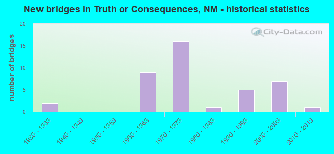
- New bridges - historical statistics
- 21930-1939
- 91960-1969
- 161970-1979
- 11980-1989
- 51990-1999
- 72000-2009
- 12010-2019

- Reconstructed bridges - Historical Statistics
- 11960-1969
- 01970-1979
- 01980-1989
- 01990-1999
- 02000-2009
- 12010-2019


- Bridge Condition - Deck
- 68.2%Good
- 27.3%Satisfactory
- 4.5%Poor

- Bridge Condition - Superstructure
- 59.1%Good
- 31.8%Satisfactory
- 9.1%Fair

- Bridge Condition - Substructure
- 50.0%Good
- 36.4%Satisfactory
- 13.6%Fair

- Bridge Condition - Channel
- 65.2%Good
- 8.7%Satisfactory
- 21.7%Fair
- 4.3%Poor

- Bridge Condition - Culverts
- 55.6%Good
- 44.4%Satisfactory
Find on map >> Show street view
Structure Number: 1756, Location: 5.3 M N of T OR C/exit 83 (Lat: 33.204914, Lng: -107.251142), Route carried "on" structure: State highway 181, Year Built: 1935, Status: Open, Structure Length: 3.11m (10.20ft), Average Daily Traffic: 150 (year 2020), Truck Traffic: 20%, Average Future Daily Traffic: 129 (year 2040), Design Load: H 15, Features Intersected: Yapple Canyon
Minimum Vertical Clearance: 30+ m (98+ ft), Kilometerpoint: 6.164, Lanes on structure: 2, Owner: State Highway Agency, Approaching Roadway Width: 7.0m (23.0ft), Material/Design: Steel, Design/Construction: Stringer/Multi-beam, Number Of Spans In Main Unit: 2, Length of Maximum Span: 15.2m (49.9ft), Curb-To-Curb Width: 7.5m (24.6ft), Out-to-Out Width: 8.2m (26.9ft)
Condition: Deck: Poor, Superstructure: Satisfactory, Substructure: Fair, Channel: Poor, Operating Rating: 43.7 metric tons, Method Used To Determine Operating Rating: Load Factor (LF), Inventory Rating: 24.3 metric tons, Method Used To Determine Inventory Rating: Load Factor (LF), Structural Evaluation: Somewhat better than minimum adequacy, Deck Geometry: Somewhat better than minimum adequacy, Waterway Adequacy: Equal to present desirable criteria, Approach Roadway Alignment: Better than present minimum criteria, Length Of Structure Improvement: 3.11m (10.20ft), Designated Inspection Frequency: Every 12 months, Inspection Date: August 2021, Bridge Improvement Cost: $123,000, Roadway Improvement Cost: $12,000, Total Project Cost: $185,000 ( Estimate for 2020), Deck Structure Type: Concrete Cast-file-Place
Find on map >> Show street view
Structure Number: 2076, Location: 1.25 MI S OF EXIT-89/I-25 (Lat: 33.269786, Lng: -107.279186), Route carried "on" structure: State highway 181, Year Built: 1939, Status: Open, Structure Length: 0.99m (3.25ft), Average Daily Traffic: 380 (year 2020), Truck Traffic: 21%, Average Future Daily Traffic: 327 (year 2040), Design Load: H 15, Features Intersected: CEDAR CANYON
Minimum Vertical Clearance: 30+ m (98+ ft), Kilometerpoint: 13.905, Lanes on structure: 2, Owner: State Highway Agency, Approaching Roadway Width: 7.3m (24.0ft), Material/Design: Concrete continuous, Design/Construction: Culvert, Number Of Spans In Main Unit: 5, Length of Maximum Span: 1.8m (5.9ft)
Condition: Channel: Fair, Culverts: Satisfactory, Operating Rating: 34.3 metric tons, Method Used To Determine Operating Rating: Load Factor (LF), Inventory Rating: 24.5 metric tons, Method Used To Determine Inventory Rating: Load Factor (LF), Structural Evaluation: Equal to present minimum criteria, Waterway Adequacy: Better than present minimum criteria, Approach Roadway Alignment: Equal to present desirable criteria, Designated Inspection Frequency: Every 24 months, Inspection Date: January 2022
Find on map >> Show street view
Structure Number: 6438, Location: 2.4 mi NE Exit 75/I-25 (Lat: 33.127947, Lng: -107.259958), Route carried "on" structure: State highway 11, Year Built: 1963, Status: Open, Structure Length: 1.34m (4.40ft), Average Daily Traffic: 8,136 (year 2020), Truck Traffic: 7%, Average Future Daily Traffic: 11,449 (year 2040), Design Load: HS 20, Features Intersected: UNNAMED WATERWAY
Minimum Vertical Clearance: 30+ m (98+ ft), Kilometerpoint: 1.786, Lanes on structure: 4, Base Highway Network: Yes, Owner: State Highway Agency, Approaching Roadway Width: 21.1m (69.2ft), Skew: 4 degrees, Material/Design: Concrete continuous, Design/Construction: Culvert, Number Of Spans In Main Unit: 3, Length of Maximum Span: 3.0m (9.8ft)
Condition: Channel: Fair, Culverts: Satisfactory, Operating Rating: 39.2 metric tons, Method Used To Determine Operating Rating: Load Factor (LF), Inventory Rating: 32.7 metric tons, Method Used To Determine Inventory Rating: Load Factor (LF), Structural Evaluation: Equal to present minimum criteria, Waterway Adequacy: Better than present minimum criteria, Approach Roadway Alignment: Equal to present desirable criteria, Designated Inspection Frequency: Every 24 months, Inspection Date: June 2020
Find on map >> Show street view
Structure Number: 679, Location: Junction I-25 and NM-181 (Lat: 33.223011, Lng: -107.256025), Route carried "on" structure: Interstate 25, Year Built: 1967, Status: Open, Structure Length: 6.98m (22.90ft), Average Daily Traffic: 7,108 (year 2020), Truck Traffic: 37%, Average Future Daily Traffic: 12,168 (year 2040), Design Load: HS 20, Features Intersected: NM-181
Minimum Vertical Clearance: 30+ m (98+ ft), Kilometerpoint: 134.879, Lanes on structure: 2, Lanes under structure: 2, Base Highway Network: Yes, Owner: State Highway Agency, Approaching Roadway Width: 13.9m (45.6ft), Skew: 6 degrees, Material/Design: Prestressed concrete, Design/Construction: Stringer/Multi-beam, Number Of Spans In Main Unit: 3, Length of Maximum Span: 25.6m (84.0ft), Curb-To-Curb Width: 13.1m (43.0ft), Out-to-Out Width: 14.1m (46.3ft)
Condition: Deck: Satisfactory, Superstructure: Satisfactory, Substructure: Satisfactory, Operating Rating: 53.5 metric tons, Method Used To Determine Operating Rating: Load Factor (LF), Inventory Rating: 30.8 metric tons, Method Used To Determine Inventory Rating: Load Factor (LF), Structural Evaluation: Equal to present minimum criteria, Deck Geometry: Superior to present desirable criteria, Underclear: Somewhat better than minimum adequacy, Approach Roadway Alignment: Equal to present desirable criteria, Length Of Structure Improvement: 6.10m (20.01ft), Designated Inspection Frequency: Every 24 months, Inspection Date: March 2020, Bridge Improvement Cost: $200,000, Roadway Improvement Cost: $25,000, Total Project Cost: $300,000 ( Estimate for 2030), Deck Structure Type: Concrete Cast-file-Place, Wearing Surface/Protective System: Wearing Surface: Epoxy Overlay
Find on map >> Show street view
Structure Number: 6791, Location: Junction of I-25/NM-181 (Lat: 33.223692, Lng: -107.256639), Route carried "on" structure: Interstate 25, Year Built: 1967, Status: Open, Structure Length: 7.53m (24.70ft), Average Daily Traffic: 5,106 (year 2020), Truck Traffic: 37%, Average Future Daily Traffic: 8,742 (year 2040), Design Load: HS 20, Features Intersected: NM-181
Minimum Vertical Clearance: 30+ m (98+ ft), Kilometerpoint: 134.879, Lanes on structure: 2, Lanes under structure: 2, Base Highway Network: Yes, Owner: State Highway Agency, Approaching Roadway Width: 13.7m (44.9ft), Skew: 6 degrees, Material/Design: Prestressed concrete, Design/Construction: Stringer/Multi-beam, Number Of Spans In Main Unit: 3, Length of Maximum Span: 25.6m (84.0ft), Curb-To-Curb Width: 12.6m (41.3ft), Out-to-Out Width: 14.1m (46.3ft)
Condition: Deck: Satisfactory, Superstructure: Fair, Substructure: Satisfactory, Operating Rating: 56.7 metric tons, Method Used To Determine Operating Rating: Load Factor (LF), Inventory Rating: 34.0 metric tons, Method Used To Determine Inventory Rating: Load Factor (LF), Structural Evaluation: Somewhat better than minimum adequacy, Deck Geometry: Better than present minimum criteria, Underclear: Somewhat better than minimum adequacy, Approach Roadway Alignment: Equal to present desirable criteria, Length Of Structure Improvement: 7.53m (24.70ft), Designated Inspection Frequency: Every 24 months, Inspection Date: March 2020, Bridge Improvement Cost: $570,000, Roadway Improvement Cost: $57,000, Total Project Cost: $855,000 ( Estimate for 2030), Deck Structure Type: Concrete Cast-file-Place, Wearing Surface/Protective System: Wearing Surface: Epoxy Overlay
Find on map >> Show street view
Structure Number: 6792, Location: 5.2 Mi N Jct I-25/NM-181 (Lat: 33.293611, Lng: -107.286519), Route carried "on" structure: State highway 2027, Year Built: 1967, Status: Open, Structure Length: 5.58m (18.31ft), Average Daily Traffic: 39 (year 2020), Truck Traffic: 13%, Average Future Daily Traffic: 73 (year 2040), Design Load: HS 20, Features Intersected: I-25 NBLS/SBLS
Minimum Vertical Clearance: 30+ m (98+ ft), Kilometerpoint: 1.931, Lanes on structure: 2, Lanes under structure: 4, Owner: State Highway Agency, Approaching Roadway Width: 9.5m (31.2ft), Material/Design: Prestressed concrete, Design/Construction: Stringer/Multi-beam, Number Of Spans In Main Unit: 4, Length of Maximum Span: 15.8m (51.8ft), Curb-To-Curb Width: 9.5m (31.2ft), Out-to-Out Width: 10.4m (34.1ft)
Condition: Deck: Good, Superstructure: Fair, Substructure: Satisfactory, Operating Rating: 53.5 metric tons, Method Used To Determine Operating Rating: Load Factor (LF), Inventory Rating: 32.4 metric tons, Method Used To Determine Inventory Rating: Load Factor (LF), Structural Evaluation: Somewhat better than minimum adequacy, Deck Geometry: Better than present minimum criteria, Underclear: Meets minimum limits, Approach Roadway Alignment: Equal to present minimum criteria, Length Of Structure Improvement: 6.10m (20.01ft), Designated Inspection Frequency: Every 24 months, Inspection Date: December 2020, Bridge Improvement Cost: $200,000, Roadway Improvement Cost: $25,000, Total Project Cost: $300,000 ( Estimate for 2030), Deck Structure Type: Concrete Cast-file-Place
Find on map >> Show street view
Structure Number: 6895, Location: 3.1 MI N OF NM-181 (Lat: 33.266947, Lng: -107.269906), Route carried "on" structure: Interstate 25, Year Built: 1967, Year Reconstructed: 1972, Status: Open, Structure Length: 0.62m (2.03ft), Average Daily Traffic: 5,106 (year 2020), Truck Traffic: 37%, Average Future Daily Traffic: 8,742 (year 2040), Design Load: HS 20, Features Intersected: CEDAR CANYON
Minimum Vertical Clearance: 30+ m (98+ ft), Kilometerpoint: 139.868, Lanes on structure: 4, Base Highway Network: Yes, Owner: State Highway Agency, Approaching Roadway Width: 26.3m (86.3ft), Skew: 20 degrees, Material/Design: Concrete continuous, Design/Construction: Culvert, Number Of Spans In Main Unit: 2, Length of Maximum Span: 3.0m (9.8ft)
Condition: Channel: Satisfactory, Culverts: Satisfactory, Operating Rating: 98.0 metric tons, Method Used To Determine Operating Rating: Load Factor (LF), Inventory Rating: 32.7 metric tons, Method Used To Determine Inventory Rating: Load Factor (LF), Structural Evaluation: Equal to present minimum criteria, Waterway Adequacy: Equal to present desirable criteria, Approach Roadway Alignment: Equal to present desirable criteria, Designated Inspection Frequency: Every 24 months, Inspection Date: June 2020
Find on map >> Show street view
Structure Number: 7103, Location: 0.7 M N Williamsburg (Lat: 33.122967, Lng: -107.293725), Route carried "on" structure: Interstate 25, Year Built: 1970, Status: Open, Structure Length: 5.94m (19.49ft), Average Daily Traffic: 7,269 (year 2020), Truck Traffic: 37%, Average Future Daily Traffic: 12,443 (year 2040), Design Load: HS 20, Features Intersected: Local Rd 51Z004/Mud Sprg
Minimum Vertical Clearance: 30+ m (98+ ft), Kilometerpoint: 121.988, Lanes on structure: 2, Lanes under structure: 2, Base Highway Network: Yes, Owner: State Highway Agency, Approaching Roadway Width: 11.4m (37.4ft), Material/Design: Prestressed concrete, Design/Construction: Stringer/Multi-beam, Number Of Spans In Main Unit: 3, Length of Maximum Span: 19.2m (63.0ft), Curb-To-Curb Width: 11.6m (38.1ft), Out-to-Out Width: 12.5m (41.0ft)
Condition: Deck: Good, Superstructure: Satisfactory, Substructure: Good, Channel: Good, Operating Rating: 54.5 metric tons, Method Used To Determine Operating Rating: Load Factor (LF), Inventory Rating: 32.7 metric tons, Method Used To Determine Inventory Rating: Load Factor (LF), Structural Evaluation: Equal to present minimum criteria, Deck Geometry: Equal to present minimum criteria, Underclear: Somewhat better than minimum adequacy, Waterway Adequacy: Better than present minimum criteria, Approach Roadway Alignment: Equal to present desirable criteria, Designated Inspection Frequency: Every 24 months, Inspection Date: March 2020, Deck Structure Type: Concrete Cast-file-Place, Wearing Surface/Protective System: Wearing Surface: Epoxy Overlay
Find on map >> Show street view
Structure Number: 7104, Location: 0.7 M N Jct Loop 001/I-25 (Lat: 33.123172, Lng: -107.293908), Route carried "on" structure: Interstate 25, Year Built: 1970, Status: Open, Structure Length: 5.94m (19.49ft), Average Daily Traffic: 7,269 (year 2020), Truck Traffic: 37%, Average Future Daily Traffic: 12,443 (year 2040), Design Load: HS 20, Features Intersected: Local Rd/Mud Spring Aryo
Minimum Vertical Clearance: 30+ m (98+ ft), Kilometerpoint: 121.988, Lanes on structure: 2, Lanes under structure: 2, Base Highway Network: Yes, Owner: State Highway Agency, Approaching Roadway Width: 11.6m (38.1ft), Material/Design: Prestressed concrete, Design/Construction: Stringer/Multi-beam, Number Of Spans In Main Unit: 3, Length of Maximum Span: 19.2m (63.0ft), Curb-To-Curb Width: 11.6m (38.1ft), Out-to-Out Width: 12.5m (41.0ft)
Condition: Deck: Good, Superstructure: Good, Substructure: Satisfactory, Channel: Good, Operating Rating: 54.5 metric tons, Method Used To Determine Operating Rating: Load Factor (LF), Inventory Rating: 32.7 metric tons, Method Used To Determine Inventory Rating: Load Factor (LF), Structural Evaluation: Equal to present minimum criteria, Deck Geometry: Equal to present minimum criteria, Underclear: Somewhat better than minimum adequacy, Waterway Adequacy: Better than present minimum criteria, Approach Roadway Alignment: Equal to present desirable criteria, Designated Inspection Frequency: Every 24 months, Inspection Date: March 2020, Deck Structure Type: Concrete Cast-file-Place, Wearing Surface/Protective System: Wearing Surface: Epoxy Overlay
Find on map >> Show street view
Structure Number: 7117, Location: North T or C Interchange (Lat: 33.157119, Lng: -107.253311), Route carried "on" structure: City street 11, Year Built: 1970, Status: Open, Structure Length: 7.71m (25.30ft), Average Daily Traffic: 2,643 (year 2020), Truck Traffic: 7%, Average Future Daily Traffic: 7,929 (year 2040), Design Load: HS 20, Features Intersected: I-25 NBL/SBL
Minimum Vertical Clearance: 30+ m (98+ ft), Kilometerpoint: 8.803, Lanes on structure: 2, Lanes under structure: 4, Base Highway Network: Yes, Owner: State Highway Agency, Approaching Roadway Width: 9.0m (29.5ft), Material/Design: Prestressed concrete, Design/Construction: Stringer/Multi-beam, Number Of Spans In Main Unit: 4, Length of Maximum Span: 26.2m (86.0ft), Curb-To-Curb Width: 9.3m (30.5ft), Out-to-Out Width: 10.4m (34.1ft)
Condition: Deck: Good, Superstructure: Good, Substructure: Good, Operating Rating: 54.5 metric tons, Method Used To Determine Operating Rating: Load Factor (LF), Inventory Rating: 31.0 metric tons, Method Used To Determine Inventory Rating: Load Factor (LF), Structural Evaluation: Better than present minimum criteria, Deck Geometry: Meets minimum limits, Underclear: Somewhat better than minimum adequacy, Approach Roadway Alignment: Equal to present desirable criteria, Length Of Structure Improvement: 7.71m (25.30ft), Designated Inspection Frequency: Every 24 months, Inspection Date: May 2021, Bridge Improvement Cost: $422,000, Roadway Improvement Cost: $42,000, Total Project Cost: $634,000 ( Estimate for 2020), Deck Structure Type: Concrete Cast-file-Place
Find on map >> Show street view
Structure Number: 7118, Location: 0.9 M N TorC Interchange (Lat: 33.170506, Lng: -107.253100), Route carried "on" structure: Interstate 25, Year Built: 1970, Status: Open, Structure Length: 15.73m (51.61ft), Average Daily Traffic: 6,124 (year 2020), Truck Traffic: 37%, Average Future Daily Traffic: 10,483 (year 2040), Design Load: HS 20, Features Intersected: Cuchillo Negro Creek/Rd
Minimum Vertical Clearance: 4.57m (14.99ft), Kilometerpoint: 129.005, Lanes on structure: 2, Lanes under structure: 2, Base Highway Network: Yes, Owner: State Highway Agency, Approaching Roadway Width: 11.8m (38.7ft), Skew: 4 degrees, Material/Design: Prestressed concrete continuous, Design/Construction: Stringer/Multi-beam, Number Of Spans In Main Unit: 7, Length of Maximum Span: 21.9m (71.9ft), Curb-To-Curb Width: 11.6m (38.1ft), Out-to-Out Width: 12.5m (41.0ft)
Condition: Deck: Good, Superstructure: Satisfactory, Substructure: Fair, Channel: Fair, Operating Rating: 53.9 metric tons, Method Used To Determine Operating Rating: Load Factor (LF), Inventory Rating: 25.6 metric tons, Method Used To Determine Inventory Rating: Load Factor (LF), Structural Evaluation: Somewhat better than minimum adequacy, Deck Geometry: Equal to present minimum criteria, Underclear: High priority of corrective action, Waterway Adequacy: Better than present minimum criteria, Approach Roadway Alignment: Equal to present desirable criteria, Length Of Structure Improvement: 6.10m (20.01ft), Designated Inspection Frequency: Every 24 months, Inspection Date: September 2020, Bridge Improvement Cost: $150,000, Roadway Improvement Cost: $50,000, Total Project Cost: $500,000 ( Estimate for 2030), Deck Structure Type: Concrete Cast-file-Place, Wearing Surface/Protective System: Wearing Surface: Latex Concrete, Deck Protection: Epoxy Coated Reinforcing
Find on map >> Show street view
Structure Number: 7119, Location: 0.9 M N I-25/T or C (Lat: 33.170756, Lng: -107.253369), Route carried "on" structure: Interstate 25, Year Built: 1970, Status: Open, Structure Length: 15.73m (51.61ft), Average Daily Traffic: 6,124 (year 2020), Truck Traffic: 37%, Average Future Daily Traffic: 10,483 (year 2040), Design Load: HS 20, Features Intersected: Cuchillo Negro Creek/lRd
Minimum Vertical Clearance: 30+ m (98+ ft), Kilometerpoint: 129.005, Lanes on structure: 2, Lanes under structure: 2, Base Highway Network: Yes, Owner: State Highway Agency, Approaching Roadway Width: 11.5m (37.7ft), Skew: 4 degrees, Material/Design: Prestressed concrete continuous, Design/Construction: Stringer/Multi-beam, Number Of Spans In Main Unit: 7, Length of Maximum Span: 21.9m (71.9ft), Curb-To-Curb Width: 11.7m (38.4ft), Out-to-Out Width: 12.5m (41.0ft)
Condition: Deck: Good, Superstructure: Good, Substructure: Fair, Channel: Fair, Operating Rating: 53.9 metric tons, Method Used To Determine Operating Rating: Load Factor (LF), Inventory Rating: 25.6 metric tons, Method Used To Determine Inventory Rating: Load Factor (LF), Structural Evaluation: Somewhat better than minimum adequacy, Deck Geometry: Equal to present minimum criteria, Underclear: High priority of corrective action, Waterway Adequacy: Equal to present desirable criteria, Approach Roadway Alignment: Equal to present desirable criteria, Length Of Structure Improvement: 6.10m (20.01ft), Designated Inspection Frequency: Every 24 months, Inspection Date: September 2020, Bridge Improvement Cost: $150,000, Roadway Improvement Cost: $50,000, Total Project Cost: $500,000 ( Estimate for 2030), Deck Structure Type: Concrete Cast-file-Place, Wearing Surface/Protective System: Deck Protection: Epoxy Coated Reinforcing
Find on map >> Show street view
Structure Number: 712, Location: 2.7 Mi N T or C N Interch (Lat: 33.210692, Lng: -107.255339), Route carried "on" structure: Interstate 25, Year Built: 1970, Status: Open, Structure Length: 3.11m (10.20ft), Average Daily Traffic: 6,124 (year 2020), Truck Traffic: 37%, Average Future Daily Traffic: 10,483 (year 2040), Design Load: HS 20, Features Intersected: Yapple Canyon
Minimum Vertical Clearance: 30+ m (98+ ft), Kilometerpoint: 133.495, Lanes on structure: 2, Base Highway Network: Yes, Owner: State Highway Agency, Approaching Roadway Width: 11.9m (39.0ft), Skew: 3 degrees, Material/Design: Concrete continuous, Design/Construction: Slab, Number Of Spans In Main Unit: 3, Length of Maximum Span: 12.2m (40.0ft), Curb-To-Curb Width: 11.7m (38.4ft), Out-to-Out Width: 12.5m (41.0ft)
Condition: Deck: Satisfactory, Superstructure: Satisfactory, Substructure: Satisfactory, Channel: Satisfactory, Operating Rating: 56.2 metric tons, Method Used To Determine Operating Rating: Load Factor (LF), Inventory Rating: 33.7 metric tons, Method Used To Determine Inventory Rating: Load Factor (LF), Structural Evaluation: Equal to present minimum criteria, Deck Geometry: Equal to present minimum criteria, Waterway Adequacy: Equal to present minimum criteria, Approach Roadway Alignment: Equal to present desirable criteria, Designated Inspection Frequency: Every 24 months, Inspection Date: March 2020, Deck Structure Type: Concrete Cast-file-Place, Wearing Surface/Protective System: Deck Protection: Epoxy Coated Reinforcing
Find on map >> Show street view
Structure Number: 7121, Location: 2.7 Mi N T or C N Interch (Lat: 33.211058, Lng: -107.255831), Route carried "on" structure: Interstate 25, Year Built: 1970, Status: Open, Structure Length: 3.11m (10.20ft), Average Daily Traffic: 6,124 (year 2020), Truck Traffic: 37%, Average Future Daily Traffic: 10,483 (year 2040), Design Load: HS 20, Features Intersected: Yapple Canyon
Minimum Vertical Clearance: 30+ m (98+ ft), Kilometerpoint: 133.495, Lanes on structure: 2, Base Highway Network: Yes, Owner: State Highway Agency, Approaching Roadway Width: 11.9m (39.0ft), Skew: 3 degrees, Material/Design: Concrete continuous, Design/Construction: Slab, Number Of Spans In Main Unit: 3, Length of Maximum Span: 12.2m (40.0ft), Curb-To-Curb Width: 11.6m (38.1ft), Out-to-Out Width: 12.5m (41.0ft)
Condition: Deck: Satisfactory, Superstructure: Satisfactory, Substructure: Good, Channel: Good, Operating Rating: 56.2 metric tons, Method Used To Determine Operating Rating: Load Factor (LF), Inventory Rating: 33.7 metric tons, Method Used To Determine Inventory Rating: Load Factor (LF), Structural Evaluation: Equal to present minimum criteria, Deck Geometry: Equal to present minimum criteria, Waterway Adequacy: Equal to present minimum criteria, Approach Roadway Alignment: Equal to present desirable criteria, Designated Inspection Frequency: Every 24 months, Inspection Date: March 2020, Deck Structure Type: Concrete Cast-file-Place, Wearing Surface/Protective System: Wearing Surface: Epoxy Overlay, Deck Protection: Epoxy Coated Reinforcing
Find on map >> Show street view
Structure Number: 7152, Location: 3.3 M N Jct Loop 001/I-25 (Lat: 33.147072, Lng: -107.258769), Route carried "on" structure: Interstate 25, Year Built: 1970, Status: Open, Structure Length: 4.60m (15.09ft), Average Daily Traffic: 7,269 (year 2020), Truck Traffic: 37%, Average Future Daily Traffic: 12,443 (year 2040), Design Load: HS 20, Features Intersected: Country Club Rd
Minimum Vertical Clearance: 30+ m (98+ ft), Kilometerpoint: 126.205, Lanes on structure: 2, Lanes under structure: 2, Base Highway Network: Yes, Owner: State Highway Agency, Approaching Roadway Width: 12.6m (41.3ft), Skew: 1 degrees, Material/Design: Prestressed concrete, Design/Construction: Stringer/Multi-beam, Number Of Spans In Main Unit: 3, Length of Maximum Span: 17.1m (56.1ft), Curb-To-Curb Width: 12.6m (41.3ft), Out-to-Out Width: 13.7m (44.9ft)
Condition: Deck: Satisfactory, Superstructure: Good, Substructure: Satisfactory, Operating Rating: 53.9 metric tons, Method Used To Determine Operating Rating: Load Factor (LF), Inventory Rating: 32.7 metric tons, Method Used To Determine Inventory Rating: Load Factor (LF), Structural Evaluation: Equal to present minimum criteria, Deck Geometry: Better than present minimum criteria, Underclear: Better than present minimum criteria, Approach Roadway Alignment: Equal to present desirable criteria, Designated Inspection Frequency: Every 24 months, Inspection Date: March 2020, Deck Structure Type: Concrete Cast-file-Place
Find on map >> Show street view
Structure Number: 7153, Location: 3.3 M N Jct Loop 001/I-25 (Lat: 33.147308, Lng: -107.258906), Route carried "on" structure: Interstate 25, Year Built: 1970, Status: Open, Structure Length: 4.63m (15.19ft), Average Daily Traffic: 7,269 (year 2020), Truck Traffic: 37%, Average Future Daily Traffic: 12,443 (year 2040), Design Load: HS 20, Features Intersected: Country Club Rd
Minimum Vertical Clearance: 30+ m (98+ ft), Kilometerpoint: 126.205, Lanes on structure: 2, Lanes under structure: 2, Base Highway Network: Yes, Owner: State Highway Agency, Approaching Roadway Width: 12.6m (41.3ft), Skew: 1 degrees, Material/Design: Prestressed concrete, Design/Construction: Stringer/Multi-beam, Number Of Spans In Main Unit: 3, Length of Maximum Span: 17.1m (56.1ft), Curb-To-Curb Width: 12.8m (42.0ft), Out-to-Out Width: 13.7m (44.9ft)
Condition: Deck: Good, Superstructure: Good, Substructure: Satisfactory, Operating Rating: 53.9 metric tons, Method Used To Determine Operating Rating: Load Factor (LF), Inventory Rating: 32.7 metric tons, Method Used To Determine Inventory Rating: Load Factor (LF), Structural Evaluation: Equal to present minimum criteria, Deck Geometry: Equal to present desirable criteria, Underclear: Equal to present minimum criteria, Approach Roadway Alignment: Equal to present desirable criteria, Designated Inspection Frequency: Every 24 months, Inspection Date: March 2020, Deck Structure Type: Concrete Cast-file-Place
Find on map >> Show street view
Structure Number: 8974, Location: 5.58 MI E OF NM-181 (Lat: 33.236283, Lng: -107.349072), Route carried "on" structure: State highway 52, Year Built: 1995, Status: Open, Structure Length: 2.68m (8.79ft), Average Daily Traffic: 207 (year 2020), Truck Traffic: 20%, Average Future Daily Traffic: 178 (year 2040), Design Load: HS 20, Features Intersected: Unnamed Waterway
Minimum Vertical Clearance: 30+ m (98+ ft), Kilometerpoint: 8.787, Lanes on structure: 2, Owner: State Highway Agency, Approaching Roadway Width: 7.9m (25.9ft), Material/Design: Concrete continuous, Design/Construction: Culvert, Number Of Spans In Main Unit: 6, Length of Maximum Span: 4.3m (14.1ft)
Condition: Channel: Fair, Culverts: Satisfactory, Operating Rating: 32.7 metric tons, Method Used To Determine Operating Rating: Load Factor (LF), Inventory Rating: 26.1 metric tons, Method Used To Determine Inventory Rating: Load Factor (LF), Structural Evaluation: Equal to present minimum criteria, Waterway Adequacy: Equal to present desirable criteria, Approach Roadway Alignment: Better than present minimum criteria, Designated Inspection Frequency: Every 24 months, Inspection Date: July 2021
Find on map >> Show street view
Structure Number: 9104, Location: 0.9 Mi N Jct I-10 & I (Lat: 32.279725, Lng: -106.736131), Route carried "on" structure: Interstate 25, Year Built: 2001, Status: Open, Structure Length: 3.23m (10.60ft), Average Daily Traffic: 7,877 (year 2020), Truck Traffic: 13%, Average Future Daily Traffic: 14,515 (year 2040), Design Load: HS 20, Features Intersected: Wells-Geothermal Drive
Minimum Vertical Clearance: 30+ m (98+ ft), Kilometerpoint: 1.448, Lanes on structure: 4, Lanes under structure: 2, Base Highway Network: Yes, Owner: State Highway Agency, Approaching Roadway Width: 15.1m (49.5ft), Skew: 31 degrees, Material/Design: Prestressed concrete, Design/Construction: Stringer/Multi-beam, Number Of Spans In Main Unit: 1, Length of Maximum Span: 31.7m (104.0ft), Curb-To-Curb Width: 13.4m (44.0ft), Out-to-Out Width: 32.0m (105.0ft)
Condition: Deck: Good, Superstructure: Good, Substructure: Good, Operating Rating: 73.2 metric tons, Method Used To Determine Operating Rating: Load Factor (LF), Inventory Rating: 26.9 metric tons, Method Used To Determine Inventory Rating: Load Factor (LF), Structural Evaluation: Equal to present minimum criteria, Deck Geometry: High priority of replacement, Underclear: Superior to present desirable criteria, Approach Roadway Alignment: Equal to present desirable criteria, Designated Inspection Frequency: Every 24 months, Inspection Date: March 2021, Deck Structure Type: Concrete Cast-file-Place, Wearing Surface/Protective System: Wearing Surface: Epoxy Overlay, Deck Protection: Epoxy Coated Reinforcing
Find on map >> Show street view
Structure Number: 9105, Location: 0.9 M N Jct I-10 & I-25 (Lat: 32.279842, Lng: -106.735947), Route carried "on" structure: State highway 2003, Year Built: 2001, Status: Open, Structure Length: 3.23m (10.60ft), Average Daily Traffic: 6,806 (year 2020), Truck Traffic: 7%, Average Future Daily Traffic: 11,091 (year 2040), Design Load: HS 20, Features Intersected: Well-Geothermal Drive
Minimum Vertical Clearance: 30+ m (98+ ft), Kilometerpoint: 1.448, Lanes on structure: 2, Lanes under structure: 2, Owner: State Highway Agency, Approaching Roadway Width: 13.4m (44.0ft), Skew: 1 degrees, Material/Design: Prestressed concrete, Design/Construction: Stringer/Multi-beam, Number Of Spans In Main Unit: 1, Length of Maximum Span: 31.1m (102.0ft), Curb-To-Curb Width: 13.4m (44.0ft), Out-to-Out Width: 14.0m (45.9ft)
Condition: Deck: Good, Superstructure: Good, Substructure: Good, Operating Rating: 58.3 metric tons, Method Used To Determine Operating Rating: Load Factor (LF), Inventory Rating: 32.4 metric tons, Method Used To Determine Inventory Rating: Load Factor (LF), Structural Evaluation: Better than present minimum criteria, Deck Geometry: Equal to present minimum criteria, Underclear: Better than present minimum criteria, Approach Roadway Alignment: Equal to present desirable criteria, Designated Inspection Frequency: Every 24 months, Inspection Date: March 2021, Deck Structure Type: Concrete Cast-file-Place, Wearing Surface/Protective System: Deck Protection: Epoxy Coated Reinforcing
Find on map >> Show street view
Structure Number: 9227, Location: 0.1 Mi N Paradise Blvd (Lat: 35.193406, Lng: -106.727569), Route carried "on" structure: City street 5260, Year Built: 1999, Status: Open, Structure Length: 1.19m (3.90ft), Average Daily Traffic: 10,649 (year 2020), Truck Traffic: 7%, Average Future Daily Traffic: 11,928 (year 2040), Design Load: HS 20, Features Intersected: Piedras Marcadas Arroyo
Minimum Vertical Clearance: 30+ m (98+ ft), Kilometerpoint: 0.000, Lanes on structure: 4, Owner: City or Municipal Highway Agency, Approaching Roadway Width: 7.3m (24.0ft), Skew: 21 degrees, Material/Design: Concrete continuous, Design/Construction: Culvert, Number Of Spans In Main Unit: 3, Length of Maximum Span: 3.0m (9.8ft), Curb or Sidewalk Widths: Left: 1.8m (5.9ft), Right: 0.0m
Condition: Channel: Good, Culverts: Good, Operating Rating: 53.5 metric tons, Method Used To Determine Operating Rating: Load Factor (LF), Inventory Rating: 32.4 metric tons, Method Used To Determine Inventory Rating: Load Factor (LF), Structural Evaluation: Better than present minimum criteria, Waterway Adequacy: Equal to present desirable criteria, Approach Roadway Alignment: Equal to present desirable criteria, Designated Inspection Frequency: Every 24 months, Inspection Date: Febuary 2022
Find on map >> Show street view
Structure Number: 9228, Location: 0.5 Mi N Paseo del Norte (Lat: 35.193025, Lng: -106.736183), Route carried "on" structure: City street 1001, Year Built: 1999, Status: Open, Structure Length: 0.88m (2.89ft), Average Daily Traffic: 3,791 (year 2020), Truck Traffic: 7%, Average Future Daily Traffic: 4,247 (year 2040), Design Load: HS 20, Features Intersected: Piedras Marcadas Arroyo, Facility Carried by Structure: Rainbow Blvd NBL
Minimum Vertical Clearance: 30+ m (98+ ft), Kilometerpoint: 0.805, Lanes on structure: 2, Owner: City or Municipal Highway Agency, Approaching Roadway Width: 7.7m (25.3ft), Material/Design: Prestressed concrete, Design/Construction: Box Beam or Girders - Multiple, Number Of Spans In Main Unit: 1, Length of Maximum Span: 8.2m (26.9ft), Curb or Sidewalk Widths: Left: 0.0m, Right: 4.0m (13.1ft), Curb-To-Curb Width: 7.7m (25.3ft), Out-to-Out Width: 16.0m (52.5ft)
Condition: Deck: Good, Superstructure: Good, Substructure: Good, Channel: Good, Operating Rating: 53.5 metric tons, Method Used To Determine Operating Rating: Load Factor (LF), Inventory Rating: 32.4 metric tons, Method Used To Determine Inventory Rating: Load Factor (LF), Structural Evaluation: Better than present minimum criteria, Deck Geometry: High priority of replacement, Waterway Adequacy: Equal to present desirable criteria, Approach Roadway Alignment: Equal to present desirable criteria, Designated Inspection Frequency: Every 24 months, Inspection Date: Febuary 2022, Deck Structure Type: Concrete Precast Panels, Wearing Surface/Protective System: Wearing Surface: Bituminous
Find on map >> Show street view
Structure Number: 9229, Location: 0.5 M N Paseo del Norte (Lat: 35.193011, Lng: -106.736447), Route carried "on" structure: City street 1363, Year Built: 1999, Status: Open, Structure Length: 0.91m (2.99ft), Average Daily Traffic: 3,791 (year 2020), Truck Traffic: 7%, Average Future Daily Traffic: 4,247 (year 2040), Design Load: HS 20, Features Intersected: Piedras Marcadas Arroyo, Facility Carried by Structure: RAINBOW BLVD SBL
Minimum Vertical Clearance: 30+ m (98+ ft), Kilometerpoint: 0.080, Lanes on structure: 2, Owner: City or Municipal Highway Agency, Approaching Roadway Width: 7.5m (24.6ft), Material/Design: Prestressed concrete, Design/Construction: Box Beam or Girders - Multiple, Number Of Spans In Main Unit: 1, Length of Maximum Span: 8.2m (26.9ft), Curb or Sidewalk Widths: Left: 3.7m (12.1ft), Right: 0.0m, Curb-To-Curb Width: 7.7m (25.3ft), Out-to-Out Width: 16.2m (53.1ft)
Condition: Deck: Good, Superstructure: Good, Substructure: Good, Channel: Good, Operating Rating: 53.5 metric tons, Method Used To Determine Operating Rating: Load Factor (LF), Inventory Rating: 32.4 metric tons, Method Used To Determine Inventory Rating: Load Factor (LF), Structural Evaluation: Better than present minimum criteria, Deck Geometry: High priority of replacement, Waterway Adequacy: Equal to present desirable criteria, Approach Roadway Alignment: Equal to present desirable criteria, Designated Inspection Frequency: Every 24 months, Inspection Date: Febuary 2022, Deck Structure Type: Concrete Precast Panels, Wearing Surface/Protective System: Wearing Surface: Bituminous, Deck Protection: Epoxy Coated Reinforcing
Find on map >> Show street view
Structure Number: 9231, Location: 0.3 M W Rainbow Blvd (Lat: 35.191783, Lng: -106.741575), Route carried "on" structure: City street 1000, Year Built: 1999, Status: Open, Structure Length: 0.70m (2.30ft), Average Daily Traffic: 1,637 (year 2020), Truck Traffic: 7%, Average Future Daily Traffic: 2,668 (year 2040), Design Load: HS 20, Features Intersected: Piedras Marcadas Arroyo, Facility Carried by Structure: Ventana Ranch RD
Minimum Vertical Clearance: 30+ m (98+ ft), Kilometerpoint: 0.000, Lanes on structure: 2, Owner: City or Municipal Highway Agency, Approaching Roadway Width: 11.0m (36.1ft), Material/Design: Prestressed concrete, Design/Construction: Box Beam or Girders - Multiple, Number Of Spans In Main Unit: 1, Length of Maximum Span: 6.7m (22.0ft), Curb or Sidewalk Widths: Left: 3.2m (10.5ft), Right: 3.2m (10.5ft), Curb-To-Curb Width: 11.0m (36.1ft), Out-to-Out Width: 18.3m (60.0ft)
Condition: Deck: Good, Superstructure: Good, Substructure: Good, Channel: Good, Operating Rating: 53.5 metric tons, Method Used To Determine Operating Rating: Load Factor (LF), Inventory Rating: 32.4 metric tons, Method Used To Determine Inventory Rating: Load Factor (LF), Structural Evaluation: Better than present minimum criteria, Deck Geometry: Equal to present minimum criteria, Waterway Adequacy: Equal to present desirable criteria, Approach Roadway Alignment: Equal to present desirable criteria, Designated Inspection Frequency: Every 24 months, Inspection Date: Febuary 2022, Deck Structure Type: Concrete Precast Panels, Wearing Surface/Protective System: Wearing Surface: Bituminous, Deck Protection: Epoxy Coated Reinforcing
Find on map >> Show street view
Structure Number: 9232, Location: 0.2 M S Paseo del Norte (Lat: 35.176767, Lng: -106.687636), Route carried "on" structure: City street 4079, Year Built: 1988, Status: Open, Structure Length: 0.82m (2.69ft), Average Daily Traffic: 21,326 (year 2020), Truck Traffic: 7%, Average Future Daily Traffic: 21,787 (year 2040), Design Load: HS 20, Features Intersected: Piedras Marcadas Arroyo, Facility Carried by Structure: Golf Course Road
Minimum Vertical Clearance: 30+ m (98+ ft), Kilometerpoint: 2.092, Lanes on structure: 4, Owner: City or Municipal Highway Agency, Approaching Roadway Width: 15.5m (50.9ft), Skew: 21 degrees, Material/Design: Prestressed concrete, Design/Construction: Box Beam or Girders - Multiple, Number Of Spans In Main Unit: 1, Length of Maximum Span: 7.6m (24.9ft), Curb or Sidewalk Widths: Left: 2.1m (6.9ft), Right: 2.1m (6.9ft), Curb-To-Curb Width: 15.5m (50.9ft), Out-to-Out Width: 30.5m (100.1ft)
Condition: Deck: Satisfactory, Superstructure: Satisfactory, Substructure: Satisfactory, Channel: Good, Operating Rating: 53.5 metric tons, Method Used To Determine Operating Rating: Load Factor (LF), Inventory Rating: 32.4 metric tons, Method Used To Determine Inventory Rating: Load Factor (LF), Structural Evaluation: Equal to present minimum criteria, Deck Geometry: Meets minimum limits, Waterway Adequacy: Equal to present desirable criteria, Approach Roadway Alignment: Equal to present desirable criteria, Designated Inspection Frequency: Every 24 months, Inspection Date: Febuary 2022, Deck Structure Type: Concrete Precast Panels, Wearing Surface/Protective System: Wearing Surface: Bituminous
Find on map >> Show street view
Structure Number: 94, Location: 2.2 MI E OF LOOP-11/TRUTH (Lat: 33.148886, Lng: -107.221517), Route carried "on" structure: State highway 51, Year Built: 2007, Status: Open, Structure Length: 7.27m (23.85ft), Average Daily Traffic: 1,384 (year 2020), Truck Traffic: 7%, Average Future Daily Traffic: 2,256 (year 2040), Design Load: HS 20, Features Intersected: CUCHILLO CREEK
Minimum Vertical Clearance: 30+ m (98+ ft), Kilometerpoint: 3.541, Lanes on structure: 2, Owner: State Highway Agency, Approaching Roadway Width: 12.6m (41.3ft), Material/Design: Prestressed concrete continuous, Design/Construction: Stringer/Multi-beam, Number Of Spans In Main Unit: 3, Length of Maximum Span: 27.6m (90.6ft), Curb or Sidewalk Widths: Left: 0.0m, Right: 2.3m (7.5ft), Curb-To-Curb Width: 11.0m (36.1ft), Out-to-Out Width: 13.7m (44.9ft)
Condition: Deck: Good, Superstructure: Good, Substructure: Good, Channel: Good, Operating Rating: 67.4 metric tons, Method Used To Determine Operating Rating: Load Factor (LF), Inventory Rating: 35.3 metric tons, Method Used To Determine Inventory Rating: Load Factor (LF), Structural Evaluation: Better than present minimum criteria, Deck Geometry: Equal to present minimum criteria, Waterway Adequacy: Equal to present desirable criteria, Approach Roadway Alignment: Equal to present desirable criteria, Designated Inspection Frequency: Every 24 months, Inspection Date: Febuary 2022, Deck Structure Type: Concrete Cast-file-Place, Wearing Surface/Protective System: Deck Protection: Epoxy Coated Reinforcing
Find on map >> Show street view
Structure Number: 9401, Location: 3.1 MI E OF LOOP-11\TRUTH (Lat: 33.144919, Lng: -107.208883), Route carried "on" structure: State highway 51, Year Built: 2007, Status: Open, Structure Length: 10.86m (35.63ft), Average Daily Traffic: 590 (year 2020), Truck Traffic: 21%, Average Future Daily Traffic: 507 (year 2040), Design Load: HS 20, Features Intersected: RIO GRANDE
Minimum Vertical Clearance: 30+ m (98+ ft), Kilometerpoint: 4.989, Lanes on structure: 2, Owner: State Highway Agency, Approaching Roadway Width: 12.7m (41.7ft), Skew: 2 degrees, Material/Design: Prestressed concrete continuous, Design/Construction: Stringer/Multi-beam, Number Of Spans In Main Unit: 4, Length of Maximum Span: 26.8m (87.9ft), Curb or Sidewalk Widths: Left: 0.0m, Right: 2.3m (7.5ft), Curb-To-Curb Width: 11.0m (36.1ft), Out-to-Out Width: 13.7m (44.9ft)
Condition: Deck: Good, Superstructure: Good, Substructure: Good, Channel: Good, Operating Rating: 74.4 metric tons, Method Used To Determine Operating Rating: Load Factor (LF), Inventory Rating: 33.6 metric tons, Method Used To Determine Inventory Rating: Load Factor (LF), Structural Evaluation: Better than present minimum criteria, Deck Geometry: Better than present minimum criteria, Waterway Adequacy: Equal to present desirable criteria, Approach Roadway Alignment: Equal to present desirable criteria, Designated Inspection Frequency: Every 24 months, Inspection Date: Febuary 2022, Deck Structure Type: Concrete Cast-file-Place, Wearing Surface/Protective System: Deck Protection: Epoxy Coated Reinforcing
Find on map >> Show street view
Structure Number: 9472, Location: 1.8 MI. EAST ON BROAD AVE (Lat: 33.126744, Lng: -107.268889), Route carried "on" structure: City street 51001, Year Built: 2003, Status: Open, Structure Length: 1.12m (3.67ft), Average Daily Traffic: 56 (year 2020), Average Future Daily Traffic: 94 (year 2040), Design Load: HS 20, Features Intersected: Flood Control Ditch, Facility Carried by Structure: 51-A001
Minimum Vertical Clearance: 30+ m (98+ ft), Kilometerpoint: 0.000, Lanes on structure: 2, Owner: City or Municipal Highway Agency, Approaching Roadway Width: 9.1m (29.9ft), Material/Design: Concrete continuous, Design/Construction: Culvert, Number Of Spans In Main Unit: 3, Length of Maximum Span: 3.7m (12.1ft)
Condition: Channel: Good, Culverts: Good, Operating Rating: 53.9 metric tons, Method Used To Determine Operating Rating: Load Factor (LF), Inventory Rating: 32.7 metric tons, Method Used To Determine Inventory Rating: Load Factor (LF), Structural Evaluation: Better than present minimum criteria, Waterway Adequacy: Equal to present desirable criteria, Approach Roadway Alignment: Equal to present desirable criteria, Length Of Structure Improvement: 6.10m (20.01ft), Designated Inspection Frequency: Every 24 months, Inspection Date: May 2021, Bridge Improvement Cost: $300,000, Roadway Improvement Cost: $150,000, Total Project Cost: $800,000 ( Estimate for 2040)
Find on map >> Show street view
Structure Number: 9473, Location: 1.8 MI EAST BROAD AVE (Lat: 33.126058, Lng: -107.268708), Route carried "on" structure: City street 51001, Year Built: 2003, Status: Open, Structure Length: 1.13m (3.71ft), Average Daily Traffic: 56 (year 2020), Average Future Daily Traffic: 94 (year 2040), Design Load: HS 20, Features Intersected: FLOOD CONTROL DITCH, Facility Carried by Structure: CORIZNE STREET
Minimum Vertical Clearance: 30+ m (98+ ft), Kilometerpoint: 0.000, Lanes on structure: 2, Owner: City or Municipal Highway Agency, Approaching Roadway Width: 8.8m (28.9ft), Material/Design: Concrete continuous, Design/Construction: Culvert, Number Of Spans In Main Unit: 3, Length of Maximum Span: 3.7m (12.1ft)
Condition: Channel: Good, Culverts: Good, Operating Rating: 53.9 metric tons, Method Used To Determine Operating Rating: Load Factor (LF), Inventory Rating: 32.7 metric tons, Method Used To Determine Inventory Rating: Load Factor (LF), Structural Evaluation: Better than present minimum criteria, Waterway Adequacy: Equal to present desirable criteria, Approach Roadway Alignment: Equal to present desirable criteria, Length Of Structure Improvement: 6.10m (20.01ft), Designated Inspection Frequency: Every 24 months, Inspection Date: May 2021, Bridge Improvement Cost: $250,000, Roadway Improvement Cost: $100,000, Total Project Cost: $600,000 ( Estimate for 2040)
Find on map >> Show street view
Structure Number: 9474, Location: 1.8 MI EAST BROAD AVE (Lat: 33.125058, Lng: -107.268658), Route carried "on" structure: City street 51001, Year Built: 2003, Status: Open, Structure Length: 1.13m (3.71ft), Average Daily Traffic: 56 (year 2020), Average Future Daily Traffic: 94 (year 2040), Design Load: HS 20, Features Intersected: FLOOD CONTROL DITCH, Facility Carried by Structure: 51-A001
Minimum Vertical Clearance: 30+ m (98+ ft), Kilometerpoint: 0.000, Lanes on structure: 2, Owner: City or Municipal Highway Agency, Approaching Roadway Width: 9.1m (29.9ft), Material/Design: Concrete continuous, Design/Construction: Culvert, Number Of Spans In Main Unit: 3, Length of Maximum Span: 0.0m
Condition: Channel: Good, Culverts: Good, Operating Rating: 53.9 metric tons, Method Used To Determine Operating Rating: Load Factor (LF), Inventory Rating: 32.7 metric tons, Method Used To Determine Inventory Rating: Load Factor (LF), Structural Evaluation: Better than present minimum criteria, Waterway Adequacy: Equal to present desirable criteria, Length Of Structure Improvement: 6.10m (20.01ft), Designated Inspection Frequency: Every 24 months, Inspection Date: May 2021, Bridge Improvement Cost: $250,000, Roadway Improvement Cost: $150,000, Total Project Cost: $750,000 ( Estimate for 2040)
Find on map >> Show street view
Structure Number: 9642, Location: 6.59 M N Jct NM-181/I-25 (Lat: 33.312667, Lng: -107.291053), Route carried "on" structure: Interstate 25, Year Built: 1967, Year Reconstructed: 2015, Status: Open, Structure Length: 11.09m (36.38ft), Average Daily Traffic: 5,244 (year 2020), Truck Traffic: 37%, Average Future Daily Traffic: 8,977 (year 2040), Design Load: HS 20, Features Intersected: Alamosa River
Minimum Vertical Clearance: 30+ m (98+ ft), Kilometerpoint: 145.404, Lanes on structure: 2, Base Highway Network: Yes, Owner: State Highway Agency, Approaching Roadway Width: 12.2m (40.0ft), Material/Design: Prestressed concrete continuous, Design/Construction: Stringer/Multi-beam, Number Of Spans In Main Unit: 5, Length of Maximum Span: 22.1m (72.5ft), Curb-To-Curb Width: 11.6m (38.1ft), Out-to-Out Width: 12.5m (41.0ft)
Condition: Deck: Good, Superstructure: Good, Substructure: Good, Channel: Good, Operating Rating: 94.2 metric tons, Method Used To Determine Operating Rating: Load Factor (LF), Inventory Rating: 50.1 metric tons, Method Used To Determine Inventory Rating: Load Factor (LF), Structural Evaluation: Better than present minimum criteria, Deck Geometry: Equal to present minimum criteria, Waterway Adequacy: Equal to present desirable criteria, Approach Roadway Alignment: Better than present minimum criteria, Designated Inspection Frequency: Every 24 months, Inspection Date: July 2021, Deck Structure Type: Concrete Cast-file-Place
Find on map >> Show street view
Structure Number: 9809, Location: 21.8 M N fo I-25 Ex 32 (Lat: 32.966400, Lng: -107.009567), Route carried "on" structure: County highway 5105, Year Built: 2018, Status: Open, Structure Length: 2.32m (7.61ft), Average Daily Traffic: 187 (year 2020), Truck Traffic: 15%, Average Future Daily Traffic: 350 (year 2040), Design Load: HS 20, Features Intersected: Yost Arroya, Facility Carried by Structure: A-013
Minimum Vertical Clearance: 30+ m (98+ ft), Kilometerpoint: 35.084, Lanes on structure: 2, Base Highway Network: Yes, Owner: County Highway Agency, Approaching Roadway Width: 9.4m (30.8ft), Material/Design: Concrete continuous, Design/Construction: Culvert, Number Of Spans In Main Unit: 3, Length of Maximum Span: 0.0m, Curb-To-Curb Width: 6.9m (22.6ft), Out-to-Out Width: 9.3m (30.5ft)
Condition: Channel: Good, Culverts: Good, Operating Rating: 75.6 metric tons, Method Used To Determine Operating Rating: Load Factor (LF), Inventory Rating: 45.4 metric tons, Method Used To Determine Inventory Rating: Load Factor (LF), Structural Evaluation: Better than present minimum criteria, Deck Geometry: Meets minimum limits, Waterway Adequacy: Better than present minimum criteria, Approach Roadway Alignment: Better than present minimum criteria, Designated Inspection Frequency: Every 24 months, Inspection Date: September 2020, Deck Structure Type: Concrete Cast-file-Place, Wearing Surface/Protective System: Wearing Surface: Other, Membrane: Other, Deck Protection: Epoxy Coated Reinforcing
Find on map >> Show street view
Structure Number: 679, Location: Junction I-25 and NM-181 (Lat: 33.223011, Lng: -107.256025), Route carried "under" structure: State highway 181, Year Built: 1967, Structure Length: 0. m, Average Daily Traffic: 506 (year 2020), Truck Traffic: 21%, Features Intersected: NM-181, Facility Carried by Structure: I-25 NB
Minimum Vertical Clearance: 4.61m (15.12ft), Kilometerpoint: 8.530, Lanes on structure: 2, Lanes under structure: 2, Material/Design: Prestressed concrete, Design/Construction: Stringer/Multi-beam, Length of Maximum Span: 25.6m (84.0ft)
Find on map >> Show street view
Structure Number: 6791, Location: Junction of I-25/NM-181 (Lat: 33.223692, Lng: -107.256639), Route carried "under" structure: State highway 181, Year Built: 1967, Structure Length: 0. m, Average Daily Traffic: 506 (year 2020), Truck Traffic: 21%, Features Intersected: NM-181, Facility Carried by Structure: I-25 SB
Minimum Vertical Clearance: 4.91m (16.11ft), Kilometerpoint: 8.530, Lanes on structure: 2, Lanes under structure: 2, Material/Design: Prestressed concrete, Design/Construction: Stringer/Multi-beam, Length of Maximum Span: 25.6m (84.0ft)
Find on map >> Show street view
Structure Number: 6792, Location: 5.2 Mi N Jct I-25/NM-181 (Lat: 33.293611, Lng: -107.286519), Route carried "under" structure: Interstate 25, Year Built: 1967, Structure Length: 0. m, Average Daily Traffic: 5,244 (year 2020), Truck Traffic: 37%, Features Intersected: I-25 NBLS/SBLS, Facility Carried by Structure: FR-2027
Minimum Vertical Clearance: 4.91m (16.11ft), Kilometerpoint: 143.280, Lanes on structure: 2, Lanes under structure: 4, Material/Design: Prestressed concrete, Design/Construction: Stringer/Multi-beam, Length of Maximum Span: 15.8m (51.8ft)
Find on map >> Show street view
Structure Number: 7103, Location: 0.7 M N Williamsburg (Lat: 33.122967, Lng: -107.293725), Route carried "under" structure: County highway 51099, Year Built: 1970, Structure Length: 0. m, Average Daily Traffic: 1,857 (year 2020), Truck Traffic: 16%, Features Intersected: Local Rd 51Z004/Mud Sprg, Facility Carried by Structure: I-25 NBL
Minimum Vertical Clearance: 5.06m (16.60ft), Kilometerpoint: 0.008, Lanes on structure: 2, Lanes under structure: 2, Material/Design: Prestressed concrete, Design/Construction: Stringer/Multi-beam, Length of Maximum Span: 19.2m (63.0ft)
Find on map >> Show street view
Structure Number: 7104, Location: 0.7 M N Jct Loop 001/I-25 (Lat: 33.123172, Lng: -107.293908), Route carried "under" structure: County highway 51099, Year Built: 1970, Structure Length: 0. m, Average Daily Traffic: 1,857 (year 2020), Truck Traffic: 16%, Features Intersected: Local Rd/Mud Spring Aryo, Facility Carried by Structure: I-25 SBL
Minimum Vertical Clearance: 4.66m (15.29ft), Kilometerpoint: 0.008, Lanes on structure: 2, Lanes under structure: 2, Material/Design: Prestressed concrete, Design/Construction: Stringer/Multi-beam, Length of Maximum Span: 19.2m (63.0ft)
Find on map >> Show street view
Structure Number: 7117, Location: North T or C Interchange (Lat: 33.157119, Lng: -107.253311), Route carried "under" structure: Interstate 25, Year Built: 1970, Structure Length: 0. m, Average Daily Traffic: 3,424 (year 2020), Truck Traffic: 51%, Features Intersected: I-25 NBL/SBL, Facility Carried by Structure: L-00011
Minimum Vertical Clearance: 5.06m (16.60ft), Kilometerpoint: 127.508, Lanes on structure: 2, Lanes under structure: 4, Material/Design: Prestressed concrete, Design/Construction: Stringer/Multi-beam, Length of Maximum Span: 26.2m (86.0ft)
Find on map >> Show street view
Structure Number: 7118, Location: 0.9 M N TorC Interchange (Lat: 33.170506, Lng: -107.253100), Route carried "under" structure: County highway 51000, Year Built: 1970, Structure Length: 0. m, Average Daily Traffic: 156 (year 2020), Truck Traffic: 15%, Features Intersected: Cuchillo Negro Creek/Rd, Facility Carried by Structure: I-25 NBL
Minimum Vertical Clearance: 4.57m (14.99ft), Kilometerpoint: 0.002, Lanes on structure: 2, Lanes under structure: 2, Material/Design: Prestressed concrete continuous, Design/Construction: Stringer/Multi-beam, Length of Maximum Span: 21.9m (71.9ft)
Find on map >> Show street view
Structure Number: 7119, Location: 0.9 M N I-25/T or C (Lat: 33.170756, Lng: -107.253369), Route carried "under" structure: County highway 51000, Year Built: 1970, Structure Length: 0. m, Average Daily Traffic: 156 (year 2020), Truck Traffic: 15%, Features Intersected: Cuchillo Negro Creek/lRd, Facility Carried by Structure: I-25 SBL
Minimum Vertical Clearance: 4.69m (15.39ft), Kilometerpoint: 0.002, Lanes on structure: 2, Lanes under structure: 1, Material/Design: Prestressed concrete continuous, Design/Construction: Stringer/Multi-beam, Length of Maximum Span: 21.9m (71.9ft)
Find on map >> Show street view
Structure Number: 7152, Location: 3.3 M N Jct Loop 001/I-25 (Lat: 33.147072, Lng: -107.258769), Route carried "under" structure: City street 5194, Year Built: 1970, Structure Length: 0. m, Average Daily Traffic: 2,014 (year 2020), Truck Traffic: 21%, Features Intersected: Country Club Rd, Facility Carried by Structure: I-25 NBL
Minimum Vertical Clearance: 6.37m (20.90ft), Kilometerpoint: 0.966, Lanes on structure: 2, Lanes under structure: 2, Material/Design: Prestressed concrete, Design/Construction: Stringer/Multi-beam, Length of Maximum Span: 17.1m (56.1ft)
Find on map >> Show street view
Structure Number: 7153, Location: 3.3 M N Jct Loop 001/I-25 (Lat: 33.147308, Lng: -107.258906), Route carried "under" structure: City street 5194, Year Built: 1970, Structure Length: 0. m, Average Daily Traffic: 2,014 (year 2020), Truck Traffic: 21%, Features Intersected: Country Club Rd, Facility Carried by Structure: I-25 SBL
Minimum Vertical Clearance: 5.97m (19.59ft), Kilometerpoint: 0.966, Lanes on structure: 2, Lanes under structure: 2, Material/Design: Prestressed concrete, Design/Construction: Stringer/Multi-beam, Length of Maximum Span: 17.1m (56.1ft)