Bridge Statistics for Tigard, Oregon (OR)
Condition, Traffic, Stress, Structural Evaluation, Project Costs
- National Bridge Inventory (NBI) Statistics
- 33Number of bridges
- 479ft / 146mTotal length
- $12,658,000Total costs
- 1,405,646Total average daily traffic
- 94,819Total average daily truck traffic
- National Bridge Inventory (NBI) Registered Bridges for Tigard
- No street view available for this location
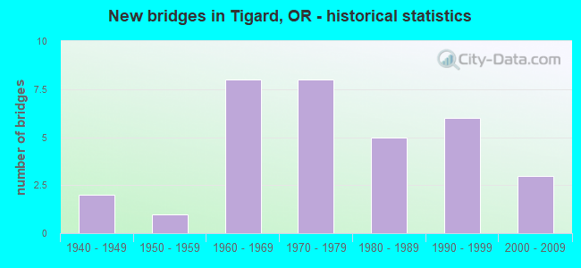
- New bridges - historical statistics
- 21940-1949
- 11950-1959
- 81960-1969
- 81970-1979
- 51980-1989
- 61990-1999
- 32000-2009

- Reconstructed bridges - Historical Statistics
- 11960-1969
- 01970-1979
- 01980-1989
- 21990-1999


- Bridge Condition - Deck
- 34.8%Good
- 56.5%Satisfactory
- 8.7%Fair

- Bridge Condition - Superstructure
- 47.8%Good
- 47.8%Satisfactory
- 4.3%Poor

- Bridge Condition - Substructure
- 34.8%Good
- 52.2%Satisfactory
- 8.7%Fair
- 4.3%Serious

- Bridge Condition - Channel
- 21.4%Good
- 64.3%Satisfactory
- 14.3%Fair
Find on map >> Show street view
Structure Number: 2259C001 29097, Location: 1.1 MI N OF TUALATIN R. (Lat: 45.403200, Lng: -122.744703), Route carried "on" structure: Interstate 5, Year Built: 1975, Status: Open, Structure Length: 5.12m (16.80ft), Average Daily Traffic: 135,007 (year 2020), Truck Traffic: 11%, Average Future Daily Traffic: 187,100 (year 2040), Design Load: HS 20, Features Intersected: P&W RR
Minimum Vertical Clearance: 30+ m (98+ ft), Kilometerpoint: 468.271, Lanes on structure: 8, Base Highway Network: Yes, Owner: State Highway Agency, Approaching Roadway Width: 42.6m (139.8ft), Skew: 32 degrees, Material/Design: Prestressed concrete continuous, Design/Construction: Stringer/Multi-beam, Number Of Spans In Main Unit: 3, Length of Maximum Span: 17.1m (56.1ft), Curb-To-Curb Width: 42.6m (139.8ft), Out-to-Out Width: 44.2m (145.0ft)
Condition: Deck: Satisfactory, Superstructure: Good, Substructure: Good, Operating Rating: 24.9 metric tons, Method Used To Determine Operating Rating: Load and Resistance Factor Rating (LRFR) rating reported by rating factor(RF) method using HL-93 loadings, Inventory Rating: 19.1 metric tons, Method Used To Determine Inventory Rating: Load and Resistance Factor Rating (LRFR) rating reported by rating factor(RF) method using HL-93 loadings, Structural Evaluation: Meets minimum limits, Deck Geometry: Superior to present desirable criteria, Underclear: Superior to present desirable criteria, Approach Roadway Alignment: Equal to present desirable criteria, Designated Inspection Frequency: Every 24 months, Inspection Date: January 2020, Deck Structure Type: Concrete Cast-file-Place, Wearing Surface/Protective System: Wearing Surface: Epoxy Overlay
Find on map >> Show street view
Structure Number: 2532 01W 00921, Location: AT TIGARD CC (Lat: 45.431283, Lng: -122.771892), Route carried "on" structure: State highway 99, Year Built: 1940, Status: Open, Structure Length: 10.45m (34.28ft), Average Daily Traffic: 34,462 (year 2020), Truck Traffic: 4%, Average Future Daily Traffic: 44,600 (year 2040), Design Load: H 15, Features Intersected: PNWR, Facility Carried by Structure: HWY 1W
Minimum Vertical Clearance: 30+ m (98+ ft), Kilometerpoint: 14.822, Lanes on structure: 4, Lanes under structure: 4, Base Highway Network: Yes, Owner: State Highway Agency, Approaching Roadway Width: 15.8m (51.8ft), Skew: 1 degrees, Material/Design: Concrete continuous, Design/Construction: Tee Beam, Number Of Spans In Main Unit: 7, Length of Maximum Span: 17.5m (57.4ft), Curb or Sidewalk Widths: Left: 1.5m (4.9ft), Right: 1.5m (4.9ft), Curb-To-Curb Width: 15.8m (51.8ft), Out-to-Out Width: 19.4m (63.6ft)
Condition: Deck: Satisfactory, Superstructure: Satisfactory, Substructure: Satisfactory, Operating Rating: 21.7 metric tons, Method Used To Determine Operating Rating: Load and Resistance Factor Rating (LRFR) rating reported by rating factor(RF) method using HL-93 loadings, Inventory Rating: 16.8 metric tons, Method Used To Determine Inventory Rating: Load and Resistance Factor Rating (LRFR) rating reported by rating factor(RF) method using HL-93 loadings, Structural Evaluation: Meets minimum limits, Deck Geometry: Meets minimum limits, Underclear: Somewhat better than minimum adequacy, Approach Roadway Alignment: Equal to present desirable criteria, Length Of Structure Improvement: 10.50m (34.45ft), Designated Inspection Frequency: Every 24 months, Inspection Date: Febuary 2020, Bridge Improvement Cost: $2,269,000, Roadway Improvement Cost: $227,000, Total Project Cost: $3,630,000, Deck Structure Type: Concrete Cast-file-Place, Wearing Surface/Protective System: Wearing Surface: Bituminous
Find on map >> Show street view
Structure Number: 2533 01W 00937, Location: AT TIGARD CC (Lat: 45.429767, Lng: -122.774219), Route carried "on" structure: State highway 99, Year Built: 1940, Status: Open, Structure Length: 3.78m (12.40ft), Average Daily Traffic: 34,462 (year 2020), Truck Traffic: 4%, Average Future Daily Traffic: 44,600 (year 2040), Design Load: H 15, Features Intersected: FANNO CREEK, Facility Carried by Structure: HWY 1W
Minimum Vertical Clearance: 30+ m (98+ ft), Kilometerpoint: 15.080, Lanes on structure: 4, Base Highway Network: Yes, Owner: State Highway Agency, Approaching Roadway Width: 15.8m (51.8ft), Material/Design: Concrete continuous, Design/Construction: Tee Beam, Number Of Spans In Main Unit: 3, Length of Maximum Span: 15.2m (49.9ft), Curb or Sidewalk Widths: Left: 1.5m (4.9ft), Right: 1.5m (4.9ft), Curb-To-Curb Width: 15.8m (51.8ft), Out-to-Out Width: 20.0m (65.6ft)
Condition: Deck: Satisfactory, Superstructure: Satisfactory, Substructure: Satisfactory, Channel: Good, Operating Rating: 30.8 metric tons, Method Used To Determine Operating Rating: Load Factor (LF), Inventory Rating: 18.1 metric tons, Method Used To Determine Inventory Rating: Load Factor (LF), Structural Evaluation: Meets minimum limits, Deck Geometry: Meets minimum limits, Waterway Adequacy: Equal to present desirable criteria, Approach Roadway Alignment: Equal to present minimum criteria, Designated Inspection Frequency: Every 24 months, Underwater Inspection Frequency: Every 60 months, Inspection Date: Febuary 2020, Underwater Inspection Date: May 2018, Deck Structure Type: Concrete Cast-file-Place, Wearing Surface/Protective System: Wearing Surface: Bituminous
Find on map >> Show street view
Structure Number: 4968 141 00573, Location: 2.9 MI S OF HWY 143 (Lat: 45.423689, Lng: -122.765731), Route carried "on" structure: State highway 141, Year Built: 1965, Status: Open, Structure Length: 2.93m (9.61ft), Average Daily Traffic: 11,275 (year 2020), Truck Traffic: 3%, Average Future Daily Traffic: 19,700 (year 2040), Design Load: HS 20, Features Intersected: FANNO CREEK
Minimum Vertical Clearance: 30+ m (98+ ft), Kilometerpoint: 9.222, Lanes on structure: 2, Owner: State Highway Agency, Approaching Roadway Width: 9.8m (32.2ft), Skew: 4 degrees, Material/Design: Prestressed concrete, Design/Construction: Slab, Number Of Spans In Main Unit: 4, Length of Maximum Span: 8.2m (26.9ft), Curb or Sidewalk Widths: Left: 1.0m (3.3ft), Right: 1.0m (3.3ft), Curb-To-Curb Width: 9.8m (32.2ft), Out-to-Out Width: 12.2m (40.0ft)
Condition: Deck: Satisfactory, Superstructure: Good, Substructure: Satisfactory, Channel: Satisfactory, Operating Rating: 56.7 metric tons, Method Used To Determine Operating Rating: Load and Resistance Factor Rating (LRFR) rating reported by rating factor(RF) method using HL-93 loadings, Inventory Rating: 43.7 metric tons, Method Used To Determine Inventory Rating: Load and Resistance Factor Rating (LRFR) rating reported by rating factor(RF) method using HL-93 loadings, Structural Evaluation: Equal to present minimum criteria, Deck Geometry: Meets minimum limits, Waterway Adequacy: Equal to present minimum criteria, Approach Roadway Alignment: Equal to present desirable criteria, Designated Inspection Frequency: Every 24 months, Underwater Inspection Frequency: Every 36 months, Inspection Date: December 2021, Underwater Inspection Date: March 2021, Deck Structure Type: Concrete Cast-file-Place, Wearing Surface/Protective System: Wearing Surface: Bituminous
Find on map >> Show street view
Structure Number: 7726A001C29342, Location: 3.5 MI N OF TUALATIN RV (Lat: 45.436911, Lng: -122.744206), Route carried "on" structure: Ramp Interstate 5, Year Built: 1985, Status: Open, Structure Length: 7.13m (23.39ft), Average Daily Traffic: 8,949 (year 2020), Truck Traffic: 11%, Average Future Daily Traffic: 9,700 (year 2030), Design Load: HS 20, Features Intersected: I-5 (HWY 001), Facility Carried by Structure: HAINES ROAD
Minimum Vertical Clearance: 30+ m (98+ ft), Kilometerpoint: 471.956, Lanes on structure: 4, Lanes under structure: 8, Owner: State Highway Agency, Approaching Roadway Width: 14.6m (47.9ft), Material/Design: Prestressed concrete, Design/Construction: Box Beam or Girders - Multiple, Number Of Spans In Main Unit: 3, Length of Maximum Span: 28.0m (91.9ft), Curb or Sidewalk Widths: Left: 2.4m (7.9ft), Right: 2.4m (7.9ft), Curb-To-Curb Width: 14.6m (47.9ft), Out-to-Out Width: 20.4m (66.9ft)
Condition: Deck: Good, Superstructure: Good, Substructure: Satisfactory, Operating Rating: 23.0 metric tons, Method Used To Determine Operating Rating: Load and Resistance Factor Rating (LRFR) rating reported by rating factor(RF) method using HL-93 loadings, Inventory Rating: 17.8 metric tons, Method Used To Determine Inventory Rating: Load and Resistance Factor Rating (LRFR) rating reported by rating factor(RF) method using HL-93 loadings, Structural Evaluation: Meets minimum limits, Deck Geometry: High priority of replacement, Underclear: Meets minimum limits, Approach Roadway Alignment: Equal to present desirable criteria, Length Of Structure Improvement: 7.10m (23.29ft), Designated Inspection Frequency: Every 24 months, Inspection Date: January 2022, Bridge Improvement Cost: $1,628,000, Roadway Improvement Cost: $163,000, Total Project Cost: $2,604,000, Deck Structure Type: Concrete Precast Panels, Wearing Surface/Protective System: Wearing Surface: Bituminous
Find on map >> Show street view
Structure Number: 7728A001C2913, Location: 1.5 MI N OF TUALATIN RV (Lat: 45.407917, Lng: -122.743983), Route carried "on" structure: Ramp Interstate 5, Year Built: 1975, Status: Open, Structure Length: 10.58m (34.71ft), Average Daily Traffic: 13,860 (year 2020), Truck Traffic: 11%, Average Future Daily Traffic: 24,300 (year 2030), Design Load: HS 20, Features Intersected: I-5 (HWY 001), Facility Carried by Structure: UPPER BOONES FERRY
Minimum Vertical Clearance: 30+ m (98+ ft), Kilometerpoint: 468.802, Lanes on structure: 3, Lanes under structure: 8, Base Highway Network: Yes, Owner: State Highway Agency, Approaching Roadway Width: 17.1m (56.1ft), Skew: 4 degrees, Material/Design: Prestressed concrete continuous, Design/Construction: Box Beam or Girders - Multiple, Number Of Spans In Main Unit: 2, Number Of Approach Spans: 2, Length of Maximum Span: 44.8m (147.0ft), Curb or Sidewalk Widths: Left: 1.5m (4.9ft), Right: 2.4m (7.9ft), Curb-To-Curb Width: 17.1m (56.1ft), Out-to-Out Width: 22.3m (73.2ft)
Condition: Deck: Satisfactory, Superstructure: Satisfactory, Substructure: Satisfactory, Operating Rating: 39.5 metric tons, Method Used To Determine Operating Rating: Load and Resistance Factor Rating (LRFR) rating reported by rating factor(RF) method using HL-93 loadings, Inventory Rating: 30.5 metric tons, Method Used To Determine Inventory Rating: Load and Resistance Factor Rating (LRFR) rating reported by rating factor(RF) method using HL-93 loadings, Structural Evaluation: Equal to present minimum criteria, Deck Geometry: Superior to present desirable criteria, Underclear: Equal to present minimum criteria, Approach Roadway Alignment: Equal to present desirable criteria, Designated Inspection Frequency: Every 24 months, Inspection Date: January 2020, Deck Structure Type: Concrete Cast-file-Place, Wearing Surface/Protective System: Wearing Surface: Integral Concrete
Find on map >> Show street view
Structure Number: 7758D01WC00788, Location: 1.3 MI N OF TIGARD CC (Lat: 45.443072, Lng: -122.740100), Route carried "on" structure: Ramp State highway 99, Year Built: 1985, Status: Open, Structure Length: 8.66m (28.41ft), Average Daily Traffic: 7,902 (year 2020), Truck Traffic: 3%, Average Future Daily Traffic: 10,000 (year 2030), Design Load: HS 25 or greater, Features Intersected: I-5 (HWY 001), Facility Carried by Structure: HWY 1W NB TO 1 NB
Minimum Vertical Clearance: 30+ m (98+ ft), Kilometerpoint: 12.585, Lanes on structure: 2, Lanes under structure: 6, Base Highway Network: Yes, Owner: State Highway Agency, Approaching Roadway Width: 10.4m (34.1ft), Skew: 4 degrees, Material/Design: Steel continuous, Design/Construction: Stringer/Multi-beam, Number Of Spans In Main Unit: 2, Number Of Approach Spans: 1, Length of Maximum Span: 37.8m (124.0ft), Curb-To-Curb Width: 10.4m (34.1ft), Out-to-Out Width: 11.4m (37.4ft)
Condition: Deck: Satisfactory, Superstructure: Satisfactory, Substructure: Satisfactory, Operating Rating: 32.4 metric tons, Method Used To Determine Operating Rating: Load and Resistance Factor Rating (LRFR) rating reported by rating factor(RF) method using HL-93 loadings, Inventory Rating: 24.9 metric tons, Method Used To Determine Inventory Rating: Load and Resistance Factor Rating (LRFR) rating reported by rating factor(RF) method using HL-93 loadings, Structural Evaluation: Equal to present minimum criteria, Deck Geometry: Better than present minimum criteria, Underclear: Equal to present minimum criteria, Approach Roadway Alignment: Equal to present desirable criteria, Designated Inspection Frequency: Every 24 months, Inspection Date: Febuary 2020, Deck Structure Type: Concrete Cast-file-Place, Wearing Surface/Protective System: Wearing Surface: Monolithic Concrete, Deck Protection: Epoxy Coated Reinforcing
Find on map >> Show street view
Structure Number: 9454 141 00471, Location: 0.3 MI N OF HWY 1-W (Lat: 45.437675, Lng: -122.765378), Route carried "on" structure: State highway 141, Year Built: 1966, Status: Open, Structure Length: 8.63m (28.31ft), Average Daily Traffic: 11,920 (year 2020), Truck Traffic: 1%, Average Future Daily Traffic: 16,500 (year 2040), Design Load: HS 20, Features Intersected: OR 217 (HWY 144)
Minimum Vertical Clearance: 30+ m (98+ ft), Kilometerpoint: 7.580, Lanes on structure: 2, Lanes under structure: 6, Owner: State Highway Agency, Approaching Roadway Width: 14.6m (47.9ft), Skew: 4 degrees, Material/Design: Steel, Design/Construction: Stringer/Multi-beam, Number Of Spans In Main Unit: 1, Number Of Approach Spans: 2, Length of Maximum Span: 46.3m (151.9ft), Curb or Sidewalk Widths: Left: 1.5m (4.9ft), Right: 1.5m (4.9ft), Curb-To-Curb Width: 14.6m (47.9ft), Out-to-Out Width: 20.1m (65.9ft)
Condition: Deck: Satisfactory, Superstructure: Satisfactory, Substructure: Satisfactory, Operating Rating: 20.4 metric tons, Method Used To Determine Operating Rating: Load and Resistance Factor Rating (LRFR) rating reported by rating factor(RF) method using HL-93 loadings, Inventory Rating: 15.6 metric tons, Method Used To Determine Inventory Rating: Load and Resistance Factor Rating (LRFR) rating reported by rating factor(RF) method using HL-93 loadings, Structural Evaluation: High priority of corrective action, Deck Geometry: Superior to present desirable criteria, Underclear: Meets minimum limits, Approach Roadway Alignment: Equal to present desirable criteria, Designated Inspection Frequency: Every 24 months, Inspection Date: June 2020, Deck Structure Type: Concrete Cast-file-Place
Find on map >> Show street view
Structure Number: 9519 01W 00865, Location: 0.6 MI N OF TIGARD CC (Lat: 45.435169, Lng: -122.761789), Route carried "on" structure: State highway 99, Year Built: 1967, Status: Open, Structure Length: 6.58m (21.59ft), Average Daily Traffic: 45,472 (year 2020), Truck Traffic: 4%, Average Future Daily Traffic: 57,500 (year 2040), Design Load: HS 20, Features Intersected: OR 217 (HWY 144)
Minimum Vertical Clearance: 30+ m (98+ ft), Kilometerpoint: 13.921, Lanes on structure: 5, Lanes under structure: 5, Base Highway Network: Yes, Owner: State Highway Agency, Approaching Roadway Width: 21.9m (71.9ft), Skew: 1 degrees, Material/Design: Prestressed concrete, Design/Construction: Stringer/Multi-beam, Number Of Spans In Main Unit: 2, Number Of Approach Spans: 2, Length of Maximum Span: 30.2m (99.1ft), Curb or Sidewalk Widths: Left: 0.0m, Right: 1.5m (4.9ft), Curb-To-Curb Width: 21.9m (71.9ft), Out-to-Out Width: 25.6m (84.0ft)
Condition: Deck: Satisfactory, Superstructure: Satisfactory, Substructure: Satisfactory, Operating Rating: 25.3 metric tons, Method Used To Determine Operating Rating: Load and Resistance Factor Rating (LRFR) rating reported by rating factor(RF) method using HL-93 loadings, Inventory Rating: 19.4 metric tons, Method Used To Determine Inventory Rating: Load and Resistance Factor Rating (LRFR) rating reported by rating factor(RF) method using HL-93 loadings, Structural Evaluation: Meets minimum limits, Deck Geometry: Somewhat better than minimum adequacy, Underclear: Somewhat better than minimum adequacy, Approach Roadway Alignment: Equal to present desirable criteria, Length Of Structure Improvement: 6.60m (21.65ft), Designated Inspection Frequency: Every 24 months, Inspection Date: Febuary 2020, Bridge Improvement Cost: $1,888,000, Roadway Improvement Cost: $189,000, Total Project Cost: $3,021,000, Deck Structure Type: Concrete Cast-file-Place, Wearing Surface/Protective System: Wearing Surface: Monolithic Concrete
Find on map >> Show street view
Structure Number: 9565 144 00669, Location: 0.8 MI S OF HWY 1-W (Lat: 45.426289, Lng: -122.751631), Route carried "on" structure: Ramp City street , Year Built: 1967, Status: Open, Structure Length: 8.84m (29.00ft), Average Daily Traffic: 102,600 (year 2010), Truck Traffic: 4%, Average Future Daily Traffic: 106,300 (year 2030), Design Load: H 20, Features Intersected: HWY 144, Facility Carried by Structure: 72ND AVE
Minimum Vertical Clearance: 30+ m (98+ ft), Kilometerpoint: 10.767, Lanes on structure: 2, Lanes under structure: 8, Owner: State Highway Agency, Approaching Roadway Width: 12.0m (39.4ft), Skew: 3 degrees, Material/Design: Steel continuous, Design/Construction: Stringer/Multi-beam, Number Of Spans In Main Unit: 2, Number Of Approach Spans: 2, Length of Maximum Span: 42.1m (138.1ft), Curb or Sidewalk Widths: Left: 0.0m, Right: 1.5m (4.9ft), Curb-To-Curb Width: 12.0m (39.4ft), Out-to-Out Width: 15.3m (50.2ft)
Condition: Deck: Satisfactory, Superstructure: Good, Substructure: Satisfactory, Operating Rating: 19.8 metric tons, Method Used To Determine Operating Rating: Load and Resistance Factor Rating (LRFR) rating reported by rating factor(RF) method using HL-93 loadings, Inventory Rating: 15.2 metric tons, Method Used To Determine Inventory Rating: Load and Resistance Factor Rating (LRFR) rating reported by rating factor(RF) method using HL-93 loadings, Structural Evaluation: High priority of corrective action, Deck Geometry: Superior to present desirable criteria, Underclear: Somewhat better than minimum adequacy, Approach Roadway Alignment: Equal to present desirable criteria, Length Of Structure Improvement: 8.80m (28.87ft), Designated Inspection Frequency: Every 24 months, Inspection Date: June 2020, Bridge Improvement Cost: $1,515,000, Roadway Improvement Cost: $151,000, Total Project Cost: $2,424,000, Deck Structure Type: Concrete Cast-file-Place, Wearing Surface/Protective System: Wearing Surface: Bituminous
Find on map >> Show street view
Structure Number: M080 144 00511, Location: 0.8 MI N OF HWY 1W (Lat: 45.442400, Lng: -122.774600), Route carried "on" structure: State highway 217, Year Built: 1970, Year Reconstructed: 1973, Status: Open, Structure Length: 0.73m (2.40ft), Average Daily Traffic: 97,018 (year 2020), Truck Traffic: 3%, Average Future Daily Traffic: 119,200 (year 2040), Design Load: HS 20, Features Intersected: ASHBROOK CREEK
Minimum Vertical Clearance: 30+ m (98+ ft), Kilometerpoint: 8.224, Lanes on structure: 8, Base Highway Network: Yes, Owner: State Highway Agency, Approaching Roadway Width: 29.3m (96.1ft), Material/Design: Concrete continuous, Design/Construction: Culvert, Number Of Spans In Main Unit: 2, Length of Maximum Span: 3.7m (12.1ft)
Condition: Channel: Satisfactory, Culverts: Satisfactory, Operating Rating: 55.7 metric tons, Method Used To Determine Operating Rating: Load and Resistance Factor Rating (LRFR) rating reported by rating factor(RF) method using HL-93 loadings, Inventory Rating: 43.1 metric tons, Method Used To Determine Inventory Rating: Load and Resistance Factor Rating (LRFR) rating reported by rating factor(RF) method using HL-93 loadings, Structural Evaluation: Equal to present minimum criteria, Waterway Adequacy: Better than present minimum criteria, Approach Roadway Alignment: Equal to present desirable criteria, Designated Inspection Frequency: Every 24 months, Inspection Date: June 2020
Find on map >> Show street view
Structure Number: 13574 144C00495, Location: 0.7 N TIGARD CC (Lat: 45.443642, Lng: -122.777258), Route carried "on" structure: Ramp State highway 217, Year Built: 1973, Year Reconstructed: 1999, Status: Open, Structure Length: 6.43m (21.10ft), Average Daily Traffic: 22,802 (year 2020), Average Future Daily Traffic: 24,300 (year 2030), Design Load: HS 20, Features Intersected: HWY 144, Facility Carried by Structure: GREENBURG ROAD
Minimum Vertical Clearance: 30+ m (98+ ft), Kilometerpoint: 7.966, Lanes on structure: 5, Lanes under structure: 4, Base Highway Network: Yes, Owner: State Highway Agency, Approaching Roadway Width: 25.2m (82.7ft), Skew: 1 degrees, Material/Design: Prestressed concrete continuous, Design/Construction: Stringer/Multi-beam, Number Of Spans In Main Unit: 2, Length of Maximum Span: 33.2m (108.9ft), Curb or Sidewalk Widths: Left: 2.4m (7.9ft), Right: 2.3m (7.5ft), Curb-To-Curb Width: 25.2m (82.7ft), Out-to-Out Width: 31.1m (102.0ft)
Condition: Deck: Satisfactory, Superstructure: Good, Substructure: Good, Operating Rating: 43.4 metric tons, Method Used To Determine Operating Rating: Load and Resistance Factor Rating (LRFR) rating reported by rating factor(RF) method using HL-93 loadings, Inventory Rating: 33.7 metric tons, Method Used To Determine Inventory Rating: Load and Resistance Factor Rating (LRFR) rating reported by rating factor(RF) method using HL-93 loadings, Structural Evaluation: Better than present minimum criteria, Deck Geometry: Superior to present desirable criteria, Underclear: Meets minimum limits, Approach Roadway Alignment: Equal to present desirable criteria, Designated Inspection Frequency: Every 24 months, Inspection Date: June 2020, Deck Structure Type: Concrete Cast-file-Place, Wearing Surface/Protective System: Wearing Surface: Monolithic Concrete
Find on map >> Show street view
Structure Number: 17970 141 00756, Location: 15 MI W BOONES FERRY RD. (Lat: 45.403319, Lng: -122.754981), Route carried "on" structure: City street C0141, Year Built: 1996, Status: Open, Structure Length: 3.11m (10.20ft), Average Daily Traffic: 21,752 (year 2020), Truck Traffic: 10%, Average Future Daily Traffic: 22,502 (year 2025), Design Load: HS 25 or greater, Features Intersected: FANNO CREEK, Facility Carried by Structure: DURHAM ROAD
Minimum Vertical Clearance: 30+ m (98+ ft), Kilometerpoint: 0.000, Lanes on structure: 3, Owner: City or Municipal Highway Agency, Approaching Roadway Width: 14.6m (47.9ft), Material/Design: Prestressed concrete, Design/Construction: Tee Beam, Number Of Spans In Main Unit: 1, Length of Maximum Span: 30.5m (100.1ft), Curb or Sidewalk Widths: Left: 2.6m (8.5ft), Right: 2.6m (8.5ft), Curb-To-Curb Width: 14.6m (47.9ft), Out-to-Out Width: 20.6m (67.6ft)
Condition: Deck: Good, Superstructure: Satisfactory, Substructure: Good, Channel: Good, Operating Rating: 47.0 metric tons, Method Used To Determine Operating Rating: Load and Resistance Factor Rating (LRFR) rating reported by rating factor(RF) method using HL-93 loadings, Inventory Rating: 36.3 metric tons, Method Used To Determine Inventory Rating: Load and Resistance Factor Rating (LRFR) rating reported by rating factor(RF) method using HL-93 loadings, Structural Evaluation: Equal to present minimum criteria, Deck Geometry: Somewhat better than minimum adequacy, Waterway Adequacy: Equal to present desirable criteria, Approach Roadway Alignment: Equal to present desirable criteria, Designated Inspection Frequency: Every 24 months, Inspection Date: July 2020, Deck Structure Type: Other, Wearing Surface/Protective System: Wearing Surface: Bituminous, Deck Protection: Epoxy Coated Reinforcing
Find on map >> Show street view
Structure Number: 18014, Location: 0010 SOUTH TIGARD ST (Lat: 45.431481, Lng: -122.776469), Route carried "on" structure: City street C0000, Year Built: 1998, Status: Open, Structure Length: 2.44m (8.01ft), Average Daily Traffic: 4,248 (year 2020), Truck Traffic: 5%, Average Future Daily Traffic: 4,685 (year 2025), Design Load: HS 25 or greater, Features Intersected: FANNO CREEK, Facility Carried by Structure: GRANT AVENUE
Minimum Vertical Clearance: 30+ m (98+ ft), Kilometerpoint: 0.000, Lanes on structure: 2, Owner: City or Municipal Highway Agency, Approaching Roadway Width: 9.4m (30.8ft), Skew: 1 degrees, Material/Design: Prestressed concrete, Design/Construction: Slab, Number Of Spans In Main Unit: 1, Length of Maximum Span: 24.4m (80.1ft), Curb or Sidewalk Widths: Left: 2.0m (6.6ft), Right: 2.0m (6.6ft), Curb-To-Curb Width: 8.2m (26.9ft), Out-to-Out Width: 14.5m (47.6ft)
Condition: Deck: Good, Superstructure: Good, Substructure: Good, Channel: Satisfactory, Operating Rating: 89.8 metric tons, Method Used To Determine Operating Rating: Load Factor (LF), Inventory Rating: 56.2 metric tons, Method Used To Determine Inventory Rating: Load Factor (LF), Structural Evaluation: Better than present minimum criteria, Deck Geometry: High priority of corrective action, Waterway Adequacy: Equal to present desirable criteria, Approach Roadway Alignment: Equal to present desirable criteria, Length Of Structure Improvement: 2.40m (7.87ft), Designated Inspection Frequency: Every 24 months, Inspection Date: July 2020, Bridge Improvement Cost: $256,000, Roadway Improvement Cost: $26,000, Total Project Cost: $410,000, Deck Structure Type: Concrete Precast Panels, Wearing Surface/Protective System: Wearing Surface: Bituminous, Membrane: Preformed Fabric
Find on map >> Show street view
Structure Number: 18015 2439, Location: 003 MI SOUTH TIGARD ST (Lat: 45.433631, Lng: -122.785231), Route carried "on" structure: City street C0000, Year Built: 1998, Status: Open, Structure Length: 2.04m (6.69ft), Average Daily Traffic: 7,083 (year 2020), Truck Traffic: 5%, Average Future Daily Traffic: 7,812 (year 2025), Design Load: HS 20, Features Intersected: FANNO CREEK, Facility Carried by Structure: TIEDEMAN AVE
Minimum Vertical Clearance: 30+ m (98+ ft), Kilometerpoint: 0.000, Lanes on structure: 2, Owner: City or Municipal Highway Agency, Approaching Roadway Width: 13.4m (44.0ft), Material/Design: Prestressed concrete, Design/Construction: Slab, Number Of Spans In Main Unit: 1, Length of Maximum Span: 20.4m (66.9ft), Curb or Sidewalk Widths: Left: 2.0m (6.6ft), Right: 2.0m (6.6ft), Curb-To-Curb Width: 13.4m (44.0ft), Out-to-Out Width: 17.9m (58.7ft)
Condition: Deck: Good, Superstructure: Good, Substructure: Good, Channel: Good, Operating Rating: 88.9 metric tons, Method Used To Determine Operating Rating: Load Factor (LF), Inventory Rating: 53.5 metric tons, Method Used To Determine Inventory Rating: Load Factor (LF), Structural Evaluation: Better than present minimum criteria, Deck Geometry: Equal to present minimum criteria, Waterway Adequacy: Equal to present desirable criteria, Approach Roadway Alignment: Equal to present desirable criteria, Designated Inspection Frequency: Every 24 months, Inspection Date: July 2020, Deck Structure Type: Other, Wearing Surface/Protective System: Wearing Surface: Bituminous, Membrane: Preformed Fabric, Deck Protection: Epoxy Coated Reinforcing
Find on map >> Show street view
Structure Number: 18480 001C29225, Location: 2.63 MI N OF TUALATIN RV (Lat: 45.421022, Lng: -122.744078), Route carried "on" structure: Ramp Interstate 5, Year Built: 2001, Status: Open, Structure Length: 44.73m (146.75ft), Average Daily Traffic: 25,204 (year 2020), Truck Traffic: 11%, Average Future Daily Traffic: 68,186 (year 2030), Design Load: HS 25 or greater, Features Intersected: I-5 (HWY 001), Facility Carried by Structure: HWY 1NB TO HWY 144
Minimum Vertical Clearance: 30+ m (98+ ft), Kilometerpoint: 470.331, Lanes on structure: 2, Lanes under structure: 16, Base Highway Network: Yes, Owner: State Highway Agency, Approaching Roadway Width: 12.6m (41.3ft), Material/Design: Prestressed concrete continuous, Design/Construction: Box Beam or Girders - Single/Spread, Number Of Spans In Main Unit: 8, Length of Maximum Span: 59.2m (194.2ft), Curb-To-Curb Width: 12.6m (41.3ft), Out-to-Out Width: 13.4m (44.0ft)
Condition: Deck: Satisfactory, Superstructure: Satisfactory, Substructure: Fair, Operating Rating: 54.8 metric tons, Method Used To Determine Operating Rating: Load and Resistance Factor Rating (LRFR) rating reported by rating factor(RF) method using HL-93 loadings, Inventory Rating: 42.1 metric tons, Method Used To Determine Inventory Rating: Load and Resistance Factor Rating (LRFR) rating reported by rating factor(RF) method using HL-93 loadings, Structural Evaluation: Somewhat better than minimum adequacy, Deck Geometry: Superior to present desirable criteria, Underclear: Equal to present minimum criteria, Approach Roadway Alignment: Equal to present minimum criteria, Designated Inspection Frequency: Every 24 months, Inspection Date: January 2020, Deck Structure Type: Concrete Cast-file-Place, Wearing Surface/Protective System: Wearing Surface: Epoxy Overlay, Deck Protection: Epoxy Coated Reinforcing
Find on map >> Show street view
Structure Number: 21078, Location: 0.2 mi S of Scholls Fy Rd (Lat: 45.438989, Lng: -122.815789), Route carried "on" structure: City street , Year Built: 1996, Status: Open, Structure Length: 1.32m (4.33ft), Average Daily Traffic: 1,272 (year 2020), Truck Traffic: 10%, Average Future Daily Traffic: 1,403 (year 2025), Design Load: HS 20, Features Intersected: Summer Creek, Facility Carried by Structure: SW 135th Avenue
Minimum Vertical Clearance: 30+ m (98+ ft), Kilometerpoint: 0.000, Lanes on structure: 2, Owner: City or Municipal Highway Agency, Approaching Roadway Width: 12.2m (40.0ft), Material/Design: Prestressed concrete, Design/Construction: Slab, Number Of Spans In Main Unit: 1, Length of Maximum Span: 13.2m (43.3ft), Curb or Sidewalk Widths: Left: 1.7m (5.6ft), Right: 1.7m (5.6ft), Curb-To-Curb Width: 12.2m (40.0ft), Out-to-Out Width: 16.4m (53.8ft)
Condition: Deck: Good, Superstructure: Good, Substructure: Satisfactory, Channel: Satisfactory, Operating Rating: 85.3 metric tons, Method Used To Determine Operating Rating: Load Factor (LF), Inventory Rating: 51.7 metric tons, Method Used To Determine Inventory Rating: Load Factor (LF), Structural Evaluation: Equal to present minimum criteria, Deck Geometry: Better than present minimum criteria, Waterway Adequacy: Equal to present desirable criteria, Approach Roadway Alignment: Equal to present desirable criteria, Designated Inspection Frequency: Every 24 months, Inspection Date: September 2020, Deck Structure Type: Concrete Cast-file-Place, Wearing Surface/Protective System: Wearing Surface: Bituminous
Find on map >> Show street view
Structure Number: 21079, Location: 0.3 mi S of Scholls Fy Rd (Lat: 45.438919, Lng: -122.810739), Route carried "on" structure: City street , Year Built: 1996, Status: Open, Structure Length: 2.25m (7.38ft), Average Daily Traffic: 636 (year 2020), Truck Traffic: 5%, Average Future Daily Traffic: 702 (year 2025), Design Load: HS 25 or greater, Features Intersected: Summer Creek, Facility Carried by Structure: SW 130 Avenue
Minimum Vertical Clearance: 30+ m (98+ ft), Kilometerpoint: 0.000, Lanes on structure: 2, Owner: City or Municipal Highway Agency, Approaching Roadway Width: 9.1m (29.9ft), Skew: 7 degrees, Material/Design: Concrete, Design/Construction: Slab, Number Of Spans In Main Unit: 1, Length of Maximum Span: 22.5m (73.8ft), Curb or Sidewalk Widths: Left: 2.4m (7.9ft), Right: 2.4m (7.9ft), Curb-To-Curb Width: 9.1m (29.9ft), Out-to-Out Width: 14.7m (48.2ft)
Condition: Deck: Good, Superstructure: Good, Substructure: Good, Channel: Satisfactory, Operating Rating: 46.3 metric tons, Method Used To Determine Operating Rating: Load and Resistance Factor Rating (LRFR) rating reported by rating factor(RF) method using HL-93 loadings, Inventory Rating: 35.6 metric tons, Method Used To Determine Inventory Rating: Load and Resistance Factor Rating (LRFR) rating reported by rating factor(RF) method using HL-93 loadings, Structural Evaluation: Better than present minimum criteria, Deck Geometry: Equal to present minimum criteria, Waterway Adequacy: Equal to present minimum criteria, Approach Roadway Alignment: Equal to present minimum criteria, Designated Inspection Frequency: Every 24 months, Inspection Date: August 2020, Deck Structure Type: Concrete Cast-file-Place, Wearing Surface/Protective System: Wearing Surface: Monolithic Concrete
Find on map >> Show street view
Structure Number: 67T001, Location: 0025 MI SOUTH PACIFIC HWY (Lat: 45.429311, Lng: -122.773839), Route carried "on" structure: Business City street C0000, Year Built: 1991, Status: Open, Structure Length: 2.16m (7.09ft), Average Daily Traffic: 12,750 (year 2020), Truck Traffic: 5%, Average Future Daily Traffic: 13,500 (year 2025), Design Load: HS 20, Features Intersected: FANNO CREEK, Facility Carried by Structure: MAIN ST
Minimum Vertical Clearance: 30+ m (98+ ft), Kilometerpoint: 0.000, Lanes on structure: 2, Owner: City or Municipal Highway Agency, Approaching Roadway Width: 16.5m (54.1ft), Skew: 1 degrees, Material/Design: Prestressed concrete, Design/Construction: Slab, Number Of Spans In Main Unit: 1, Length of Maximum Span: 21.0m (68.9ft), Curb or Sidewalk Widths: Left: 2.6m (8.5ft), Right: 2.6m (8.5ft), Curb-To-Curb Width: 16.5m (54.1ft), Out-to-Out Width: 22.3m (73.2ft)
Condition: Deck: Good, Superstructure: Good, Substructure: Good, Channel: Satisfactory, Operating Rating: 47.2 metric tons, Method Used To Determine Operating Rating: Load Factor (LF), Inventory Rating: 28.1 metric tons, Method Used To Determine Inventory Rating: Load Factor (LF), Structural Evaluation: Better than present minimum criteria, Deck Geometry: Superior to present desirable criteria, Waterway Adequacy: Equal to present desirable criteria, Approach Roadway Alignment: Equal to present desirable criteria, Designated Inspection Frequency: Every 24 months, Inspection Date: July 2020, Deck Structure Type: Other, Wearing Surface/Protective System: Wearing Surface: Bituminous
Find on map >> Show street view
Structure Number: 67T002, Location: 0005 WEST OF TIEDEMAN (Lat: 45.436269, Lng: -122.784300), Route carried "on" structure: City street C0000, Year Built: 1958, Status: Open, Structure Length: 1.92m (6.30ft), Average Daily Traffic: 5,667 (year 2020), Truck Traffic: 5%, Average Future Daily Traffic: 6,250 (year 2025), Design Load: H 20, Features Intersected: FANNO CREEK, Facility Carried by Structure: TIGARD STREET
Minimum Vertical Clearance: 30+ m (98+ ft), Kilometerpoint: 0.000, Lanes on structure: 2, Owner: City or Municipal Highway Agency, Approaching Roadway Width: 9.8m (32.2ft), Material/Design: Wood or Timber, Design/Construction: Stringer/Multi-beam, Number Of Spans In Main Unit: 4, Length of Maximum Span: 4.6m (15.1ft), Curb or Sidewalk Widths: Left: 0.0m, Right: 1.8m (5.9ft), Curb-To-Curb Width: 6.1m (20.0ft), Out-to-Out Width: 8.8m (28.9ft)
Condition: Deck: Fair, Superstructure: Satisfactory, Substructure: Fair, Channel: Satisfactory, Operating Rating: 23.7 metric tons, Method Used To Determine Operating Rating: Load and Resistance Factor Rating (LRFR) rating reported by rating factor(RF) method using HL-93 loadings, Inventory Rating: 18.1 metric tons, Method Used To Determine Inventory Rating: Load and Resistance Factor Rating (LRFR) rating reported by rating factor(RF) method using HL-93 loadings, Structural Evaluation: Meets minimum limits, Deck Geometry: High priority of replacement, Waterway Adequacy: Equal to present minimum criteria, Approach Roadway Alignment: Equal to present desirable criteria, Length Of Structure Improvement: 1.90m (6.23ft), Designated Inspection Frequency: Every 24 months, Inspection Date: August 2020, Bridge Improvement Cost: $202,000, Roadway Improvement Cost: $20,000, Total Project Cost: $323,000, Deck Structure Type: Wood or Timber, Wearing Surface/Protective System: Wearing Surface: Bituminous, Membrane: Built-up
Find on map >> Show street view
Structure Number: 67T00412540005, Location: 005 MI WEST INTERSTATE 5 (Lat: 45.415200, Lng: -122.754200), Route carried "on" structure: City street C0000, Year Built: 1971, Year Reconstructed: 1996, Status: Open, Structure Length: 2.93m (9.61ft), Average Daily Traffic: 12,041 (year 2020), Truck Traffic: 5%, Average Future Daily Traffic: 13,280 (year 2025), Design Load: HS 20, Features Intersected: FANNO CREEK, Facility Carried by Structure: S W BONITA ROAD
Minimum Vertical Clearance: 30+ m (98+ ft), Kilometerpoint: 0.805, Lanes on structure: 3, Owner: City or Municipal Highway Agency, Approaching Roadway Width: 13.1m (43.0ft), Material/Design: Prestressed concrete, Design/Construction: Slab, Number Of Spans In Main Unit: 3, Length of Maximum Span: 9.8m (32.2ft), Curb or Sidewalk Widths: Left: 2.2m (7.2ft), Right: 2.0m (6.6ft), Curb-To-Curb Width: 13.2m (43.3ft), Out-to-Out Width: 18.3m (60.0ft)
Condition: Deck: Satisfactory, Superstructure: Satisfactory, Substructure: Satisfactory, Channel: Satisfactory, Operating Rating: 67.7 metric tons, Method Used To Determine Operating Rating: Load and Resistance Factor Rating (LRFR) rating reported by rating factor(RF) method using HL-93 loadings, Inventory Rating: 52.2 metric tons, Method Used To Determine Inventory Rating: Load and Resistance Factor Rating (LRFR) rating reported by rating factor(RF) method using HL-93 loadings, Structural Evaluation: Equal to present minimum criteria, Deck Geometry: Somewhat better than minimum adequacy, Waterway Adequacy: Equal to present desirable criteria, Approach Roadway Alignment: Equal to present desirable criteria, Designated Inspection Frequency: Every 24 months, Underwater Inspection Frequency: Every 60 months, Inspection Date: July 2020, Underwater Inspection Date: March 2020, Deck Structure Type: Other, Wearing Surface/Protective System: Wearing Surface: Bituminous
Find on map >> Show street view
Structure Number: 67T006, Location: 0010 W GREENBURG RD (Lat: 45.438981, Lng: -122.782800), Route carried "on" structure: City street C0000, Year Built: 1962, Status: Temporarily open, Structure Length: 1.46m (4.79ft), Average Daily Traffic: 6,925 (year 2020), Truck Traffic: 5%, Average Future Daily Traffic: 7,638 (year 2025), Design Load: HS 15, Features Intersected: FANNO CREEK, Facility Carried by Structure: NORTH DAKOTA ST
Minimum Vertical Clearance: 30+ m (98+ ft), Kilometerpoint: 0.805, Lanes on structure: 2, Owner: City or Municipal Highway Agency, Approaching Roadway Width: 6.7m (22.0ft), Material/Design: Wood or Timber, Design/Construction: Stringer/Multi-beam, Number Of Spans In Main Unit: 3, Length of Maximum Span: 4.6m (15.1ft), Curb-To-Curb Width: 5.9m (19.4ft), Out-to-Out Width: 6.3m (20.7ft)
Condition: Deck: Fair, Superstructure: Poor, Substructure: Serious, Channel: Fair, Operating Rating: 21.4 metric tons, Method Used To Determine Operating Rating: Load and Resistance Factor Rating (LRFR) rating reported by rating factor(RF) method using HL-93 loadings, Inventory Rating: 16.5 metric tons, Method Used To Determine Inventory Rating: Load and Resistance Factor Rating (LRFR) rating reported by rating factor(RF) method using HL-93 loadings, Structural Evaluation: High priority of corrective action, Deck Geometry: High priority of replacement, Waterway Adequacy: Equal to present minimum criteria, Approach Roadway Alignment: Equal to present desirable criteria, Length Of Structure Improvement: 1.50m (4.92ft), Designated Inspection Frequency: Every 12 months, Inspection Date: July 2021, Bridge Improvement Cost: $154,000, Roadway Improvement Cost: $15,000, Total Project Cost: $246,000, Deck Structure Type: Wood or Timber, Wearing Surface/Protective System: Wearing Surface: Bituminous, Membrane: Built-up
Find on map >> Show street view
Structure Number: 67T0099207, Location: 001 MI SOUTH HWY 217 (Lat: 45.440500, Lng: -122.779819), Route carried "on" structure: City street C0000, Year Built: 1989, Status: Open, Structure Length: 1.46m (4.79ft), Average Daily Traffic: 24,002 (year 2020), Truck Traffic: 10%, Average Future Daily Traffic: 34,637 (year 2025), Design Load: HS 25 or greater, Features Intersected: ASH CREEK, Facility Carried by Structure: GREENBURG ROAD
Minimum Vertical Clearance: 30+ m (98+ ft), Kilometerpoint: 14.484, Lanes on structure: 3, Owner: City or Municipal Highway Agency, Approaching Roadway Width: 14.6m (47.9ft), Skew: 20 degrees, Material/Design: Prestressed concrete, Design/Construction: Slab, Number Of Spans In Main Unit: 2, Length of Maximum Span: 6.7m (22.0ft), Curb or Sidewalk Widths: Left: 1.8m (5.9ft), Right: 1.8m (5.9ft), Curb-To-Curb Width: 14.6m (47.9ft), Out-to-Out Width: 18.7m (61.4ft)
Condition: Deck: Satisfactory, Superstructure: Satisfactory, Substructure: Satisfactory, Channel: Satisfactory, Operating Rating: 69.9 metric tons, Method Used To Determine Operating Rating: Load Factor (LF), Inventory Rating: 37.2 metric tons, Method Used To Determine Inventory Rating: Load Factor (LF), Structural Evaluation: Equal to present minimum criteria, Deck Geometry: Somewhat better than minimum adequacy, Waterway Adequacy: Equal to present minimum criteria, Approach Roadway Alignment: Equal to present desirable criteria, Designated Inspection Frequency: Every 24 months, Inspection Date: July 2020, Deck Structure Type: Other, Wearing Surface/Protective System: Wearing Surface: Bituminous
Find on map >> Show street view
Structure Number: 67T010117600008, Location: 001 MI W HALL BLVD (Lat: 45.444331, Lng: -122.766039), Route carried "on" structure: City street C0000, Year Built: 1972, Status: Open, Structure Length: 0.76m (2.49ft), Average Daily Traffic: 2,523 (year 2020), Truck Traffic: 2%, Average Future Daily Traffic: 2,858 (year 2025), Design Load: HS 20, Features Intersected: ASH CREEK, Facility Carried by Structure: S W OAK STREET
Minimum Vertical Clearance: 30+ m (98+ ft), Kilometerpoint: 0.000, Lanes on structure: 2, Owner: City or Municipal Highway Agency, Approaching Roadway Width: 11.0m (36.1ft), Material/Design: Prestressed concrete, Design/Construction: Slab, Number Of Spans In Main Unit: 1, Length of Maximum Span: 7.0m (23.0ft), Curb or Sidewalk Widths: Left: 0.3m (1.0ft), Right: 1.2m (3.9ft), Curb-To-Curb Width: 9.4m (30.8ft), Out-to-Out Width: 11.1m (36.4ft)
Condition: Deck: Good, Superstructure: Good, Substructure: Good, Channel: Fair, Operating Rating: 58.1 metric tons, Method Used To Determine Operating Rating: Load Factor (LF), Inventory Rating: 28.1 metric tons, Method Used To Determine Inventory Rating: Load Factor (LF), Structural Evaluation: Better than present minimum criteria, Deck Geometry: Meets minimum limits, Waterway Adequacy: Equal to present desirable criteria, Approach Roadway Alignment: Equal to present desirable criteria, Designated Inspection Frequency: Every 24 months, Inspection Date: July 2020, Deck Structure Type: Other, Wearing Surface/Protective System: Wearing Surface: Bituminous
Find on map >> Show street view
Structure Number: 7726A001C29342, Location: 3.5 MI N OF TUALATIN RV (Lat: 45.436911, Lng: -122.744206), Route carried "under" structure: Interstate 5, Year Built: 1985, Structure Length: 0. m, Average Daily Traffic: 86,060 (year 2020), Truck Traffic: 11%, Features Intersected: I-5 (HWY 001), Facility Carried by Structure: HAINES ROAD
Minimum Vertical Clearance: 8.13m (26.67ft), Kilometerpoint: 471.956, Lanes on structure: 4, Lanes under structure: 8, Material/Design: Prestressed concrete, Design/Construction: Box Beam or Girders - Multiple, Length of Maximum Span: 28.0m (91.9ft)
Find on map >> Show street view
Structure Number: 7728A001C2913, Location: 1.5 MI N OF TUALATIN RV (Lat: 45.407917, Lng: -122.743983), Route carried "under" structure: Interstate 5, Year Built: 1975, Structure Length: 0. m, Average Daily Traffic: 135,007 (year 2020), Truck Traffic: 11%, Features Intersected: I-5 (HWY 001), Facility Carried by Structure: UPPER BOONES FERRY
Minimum Vertical Clearance: 5.46m (17.91ft), Kilometerpoint: 468.802, Lanes on structure: 3, Lanes under structure: 8, Material/Design: Prestressed concrete continuous, Design/Construction: Box Beam or Girders - Multiple, Length of Maximum Span: 44.8m (147.0ft)
Find on map >> Show street view
Structure Number: 7758D01WC00788, Location: 1.3 MI N OF TIGARD CC (Lat: 45.443072, Lng: -122.740100), Route carried "under" structure: Interstate 5, Year Built: 1985, Structure Length: 0. m, Average Daily Traffic: 96,556 (year 2020), Truck Traffic: 11%, Features Intersected: I-5 (HWY 001), Facility Carried by Structure: HWY 1W NB TO 1 NB
Minimum Vertical Clearance: 5.82m (19.09ft), Kilometerpoint: 472.745, Lanes on structure: 2, Lanes under structure: 6, Material/Design: Steel continuous, Design/Construction: Stringer/Multi-beam, Length of Maximum Span: 37.8m (124.0ft)
Find on map >> Show street view
Structure Number: 9454 141 00471, Location: 0.3 MI N OF HWY 1-W (Lat: 45.437675, Lng: -122.765378), Route carried "under" structure: State highway 217, Year Built: 1966, Structure Length: 0. m, Average Daily Traffic: 83,136 (year 2020), Truck Traffic: 3%, Features Intersected: OR 217 (HWY 144), Facility Carried by Structure: HWY 141
Minimum Vertical Clearance: 5.94m (19.49ft), Kilometerpoint: 9.109, Lanes on structure: 2, Lanes under structure: 6, Material/Design: Steel, Design/Construction: Stringer/Multi-beam, Length of Maximum Span: 46.3m (151.9ft)
Find on map >> Show street view
Structure Number: 9519 01W 00865, Location: 0.6 MI N OF TIGARD CC (Lat: 45.435169, Lng: -122.761789), Route carried "under" structure: State highway 217, Year Built: 1967, Structure Length: 0. m, Average Daily Traffic: 83,136 (year 2020), Truck Traffic: 3%, Features Intersected: OR 217 (HWY 144), Facility Carried by Structure: OR 99W (HWY 001W)
Minimum Vertical Clearance: 5.43m (17.81ft), Kilometerpoint: 9.495, Lanes on structure: 5, Lanes under structure: 5, Material/Design: Prestressed concrete, Design/Construction: Stringer/Multi-beam, Length of Maximum Span: 30.2m (99.1ft)
Find on map >> Show street view
Structure Number: 9565 144 00669, Location: 0.8 MI S OF HWY 1-W (Lat: 45.426289, Lng: -122.751631), Route carried "under" structure: State highway 217, Year Built: 1967, Structure Length: 0. m, Average Daily Traffic: 83,310 (year 2020), Truck Traffic: 3%, Features Intersected: HWY 144, Facility Carried by Structure: 72ND AVE
Minimum Vertical Clearance: 6.27m (20.57ft), Kilometerpoint: 10.767, Lanes on structure: 2, Lanes under structure: 8, Material/Design: Steel continuous, Design/Construction: Stringer/Multi-beam, Length of Maximum Span: 42.1m (138.1ft)
Find on map >> Show street view
Structure Number: 13574 144C00495, Location: 0.7 N TIGARD CC (Lat: 45.443642, Lng: -122.777258), Route carried "under" structure: State highway 217, Year Built: 1973, Structure Length: 0. m, Average Daily Traffic: 97,018 (year 2020), Truck Traffic: 3%, Features Intersected: HWY 144, Facility Carried by Structure: GREENBURG ROAD
Minimum Vertical Clearance: 5.05m (16.57ft), Kilometerpoint: 7.966, Lanes on structure: 5, Lanes under structure: 4, Material/Design: Prestressed concrete continuous, Design/Construction: Stringer/Multi-beam, Length of Maximum Span: 33.2m (108.9ft)
Find on map >> Show street view
Structure Number: 18480 001C29225, Location: 2.63 MI N OF TUALATIN RV (Lat: 45.421022, Lng: -122.744078), Route carried "under" structure: Interstate 5, Year Built: 2001, Structure Length: 0. m, Average Daily Traffic: 88,870 (year 2020), Truck Traffic: 11%, Features Intersected: I-5 (HWY 001), Facility Carried by Structure: HWY 1NB TO HWY 144
Minimum Vertical Clearance: 8.25m (27.07ft), Kilometerpoint: 470.331, Lanes on structure: 2, Lanes under structure: 12, Material/Design: Prestressed concrete continuous, Design/Construction: Box Beam or Girders - Single/Spread, Length of Maximum Span: 59.2m (194.2ft)
Find on map >> Show street view
Structure Number: 18480 001C29225, Location: 2.63 MI N OF TUALATIN RV (Lat: 45.421022, Lng: -122.744078), Route carried "under" structure: State highway 217, Year Built: 2001, Structure Length: 0. m, Average Daily Traffic: 2,721 (year 2020), Truck Traffic: 3%, Features Intersected: I-5 (HWY 001), Facility Carried by Structure: HWY 1NB TO HWY 144
Minimum Vertical Clearance: 8.25m (27.07ft), Kilometerpoint: 11.459, Lanes on structure: 2, Lanes under structure: 4, Material/Design: Prestressed concrete continuous, Design/Construction: Box Beam or Girders - Single/Spread, Length of Maximum Span: 59.2m (194.2ft)