Bridge Statistics for Pikesville, Maryland (MD)
Condition, Traffic, Stress, Structural Evaluation, Project Costs
- National Bridge Inventory (NBI) Statistics
- 23Number of bridges
- 210ft / 64.0mTotal length
- $1,351,000Total costs
- 1,788,389Total average daily traffic
- 78,580Total average daily truck traffic
- National Bridge Inventory (NBI) Registered Bridges for Pikesville
- No street view available for this location
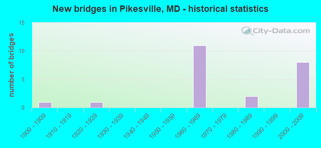
- New bridges - historical statistics
- 11900-1909
- 11920-1929
- 111960-1969
- 21980-1989
- 82000-2009

- Reconstructed bridges - Historical Statistics
- 11960-1969
- 01970-1979
- 11980-1989
- 21990-1999
- 12000-2009


- Bridge Condition - Deck
- 25.0%Very good
- 37.5%Good
- 25.0%Satisfactory
- 12.5%Fair

- Bridge Condition - Superstructure
- 10.0%Very good
- 40.0%Good
- 50.0%Satisfactory

- Bridge Condition - Substructure
- 30.0%Very good
- 20.0%Good
- 20.0%Satisfactory
- 20.0%Fair
- 10.0%Serious

- Bridge Condition - Channel
- 16.7%Very good
- 16.7%Good
- 16.7%Satisfactory
- 50.0%Fair
Find on map >> Show street view
Structure Number: 10000003014601, Location: 0.6 M S OF MT WILSON LANE (Lat: 39.384669, Lng: -76.733597), Route carried "on" structure: State highway 140, Year Built: 2002, Status: Open, Structure Length: 5.79m (19.00ft), Average Daily Traffic: 42,450 (year 2009), Truck Traffic: 4%, Average Future Daily Traffic: 46,090 (year 2029), Design Load: HS 25 or greater, Features Intersected: IS 695
Minimum Vertical Clearance: 30+ m (98+ ft), Kilometerpoint: 3.105, Lanes on structure: 4, Lanes under structure: 8, Base Highway Network: Yes, Owner: State Highway Agency, Approaching Roadway Width: 21.3m (69.9ft), Material/Design: Steel, Design/Construction: Stringer/Multi-beam, Number Of Spans In Main Unit: 2, Length of Maximum Span: 28.3m (92.8ft), Curb or Sidewalk Widths: Left: 1.4m (4.6ft), Right: 1.4m (4.6ft), Curb-To-Curb Width: 40.7m (133.5ft), Out-to-Out Width: 44.6m (146.3ft)
Condition: Deck: Good, Superstructure: Good, Substructure: Very good, Operating Rating: 62.1 metric tons, Method Used To Determine Operating Rating: Load Factor (LF), Inventory Rating: 37.2 metric tons, Method Used To Determine Inventory Rating: Load Factor (LF), Structural Evaluation: Better than present minimum criteria, Deck Geometry: Superior to present desirable criteria, Underclear: Meets minimum limits, Approach Roadway Alignment: Equal to present desirable criteria, Designated Inspection Frequency: Every 24 months, Inspection Date: June 2021, Deck Structure Type: Concrete Cast-file-Place, Wearing Surface/Protective System: Wearing Surface: Bituminous
Find on map >> Show street view
Structure Number: 10000003014801, Location: 0.50 MI N OF MD 129 (Lat: 39.391072, Lng: -76.713025), Route carried "on" structure: County highway 1600, Year Built: 1961, Year Reconstructed: 1973, Status: Open, Structure Length: 7.16m (23.49ft), Average Daily Traffic: 8,404 (year 1994), Truck Traffic: 5%, Average Future Daily Traffic: 9,916 (year 2012), Design Load: H 20, Features Intersected: IS 695, Facility Carried by Structure: STEVENSON ROAD
Minimum Vertical Clearance: 30+ m (98+ ft), Kilometerpoint: 3.894, Lanes on structure: 5, Lanes under structure: 6, Owner: State Highway Agency, Approaching Roadway Width: 18.3m (60.0ft), Skew: 21 degrees, Material/Design: Steel, Design/Construction: Stringer/Multi-beam, Number Of Spans In Main Unit: 4, Length of Maximum Span: 25.0m (82.0ft), Curb or Sidewalk Widths: Left: 1.6m (5.2ft), Right: 1.6m (5.2ft), Curb-To-Curb Width: 19.5m (64.0ft), Out-to-Out Width: 23.2m (76.1ft)
Condition: Deck: Fair, Superstructure: Satisfactory, Substructure: Fair, Operating Rating: 54.0 metric tons, Method Used To Determine Operating Rating: Load Factor (LF), Inventory Rating: 32.2 metric tons, Method Used To Determine Inventory Rating: Load Factor (LF), Structural Evaluation: Somewhat better than minimum adequacy, Deck Geometry: Meets minimum limits, Underclear: Somewhat better than minimum adequacy, Approach Roadway Alignment: Equal to present desirable criteria, Designated Inspection Frequency: Every 24 months, Inspection Date: April 2021, Deck Structure Type: Concrete Cast-file-Place, Wearing Surface/Protective System: Wearing Surface: Bituminous
Find on map >> Show street view
Structure Number: 10000003015301, Location: 0.17 MILE SOUTH OF IS 83 (Lat: 39.409447, Lng: -76.665758), Route carried "on" structure: Interstate 695, Year Built: 1961, Year Reconstructed: 1997, Status: Open, Structure Length: 9.24m (30.31ft), Average Daily Traffic: 192,739 (year 2018), Truck Traffic: 8%, Average Future Daily Traffic: 235,645 (year 2038), Design Load: HS 20, Features Intersected: IS 83 SBR & JONES FALLS
Minimum Vertical Clearance: 30+ m (98+ ft), Kilometerpoint: 27.627, Lanes on structure: 8, Lanes under structure: 2, Base Highway Network: Yes, Owner: State Highway Agency, Approaching Roadway Width: 52.1m (170.9ft), Skew: 23 degrees, Material/Design: Steel, Design/Construction: Stringer/Multi-beam, Number Of Spans In Main Unit: 5, Length of Maximum Span: 20.7m (67.9ft), Curb-To-Curb Width: 52.1m (170.9ft), Out-to-Out Width: 54.1m (177.5ft)
Condition: Deck: Satisfactory, Superstructure: Satisfactory, Substructure: Fair, Channel: Good, Inventory Rating: 62.6 metric tons, Method Used To Determine Inventory Rating: Load Factor (LF), Structural Evaluation: Somewhat better than minimum adequacy, Deck Geometry: Superior to present desirable criteria, Underclear: Somewhat better than minimum adequacy, Waterway Adequacy: Equal to present desirable criteria, Approach Roadway Alignment: Equal to present desirable criteria, Designated Inspection Frequency: Every 24 months, Inspection Date: July 2020, Deck Structure Type: Concrete Cast-file-Place, Wearing Surface/Protective System: Wearing Surface: Monolithic Concrete
Find on map >> Show street view
Structure Number: 10000003015401, Location: 0.36 MILE NORTH OF MD 25 (Lat: 0.000108, Lng: -0.000019), Route carried "on" structure: Interstate 695, Year Built: 2005, Status: Open, Structure Length: 6.55m (21.49ft), Average Daily Traffic: 176,700 (year 2009), Truck Traffic: 10%, Average Future Daily Traffic: 208,213 (year 2026), Design Load: HS 25 or greater, Features Intersected: MD 25A
Minimum Vertical Clearance: 30+ m (98+ ft), Kilometerpoint: 27.900, Lanes on structure: 8, Lanes under structure: 6, Base Highway Network: Yes, Owner: State Highway Agency, Approaching Roadway Width: 56.7m (186.0ft), Skew: 32 degrees, Material/Design: Steel continuous, Design/Construction: Stringer/Multi-beam, Number Of Spans In Main Unit: 2, Length of Maximum Span: 32.0m (105.0ft), Curb-To-Curb Width: 55.8m (183.1ft), Out-to-Out Width: 57.9m (190.0ft)
Condition: Deck: Very good, Superstructure: Good, Substructure: Very good, Inventory Rating: 60.8 metric tons, Method Used To Determine Inventory Rating: Load Factor (LF), Structural Evaluation: Better than present minimum criteria, Deck Geometry: Superior to present desirable criteria, Underclear: Meets minimum limits, Approach Roadway Alignment: Equal to present desirable criteria, Designated Inspection Frequency: Every 24 months, Inspection Date: August 2020, Deck Structure Type: Concrete Cast-file-Place, Wearing Surface/Protective System: Wearing Surface: Integral Concrete, Deck Protection: Epoxy Coated Reinforcing
Find on map >> Show street view
Structure Number: 10000003015501, Location: 0.36 MI N OF MD 25 (Lat: 0.000108, Lng: -0.000019), Route carried "on" structure: Ramp Interstate 83, Year Built: 2005, Status: Open, Structure Length: 6.43m (21.10ft), Average Daily Traffic: 32,550 (year 2006), Truck Traffic: 8%, Average Future Daily Traffic: 35,154 (year 2026), Design Load: HS 25 or greater, Features Intersected: MD 25A
Minimum Vertical Clearance: 30+ m (98+ ft), Kilometerpoint: 0.177, Lanes on structure: 2, Lanes under structure: 5, Base Highway Network: Yes, Owner: State Highway Agency, Approaching Roadway Width: 12.2m (40.0ft), Skew: 2 degrees, Material/Design: Steel continuous, Design/Construction: Stringer/Multi-beam, Number Of Spans In Main Unit: 2, Length of Maximum Span: 32.3m (106.0ft), Curb-To-Curb Width: 14.0m (45.9ft), Out-to-Out Width: 15.2m (49.9ft)
Condition: Deck: Very good, Superstructure: Very good, Substructure: Very good, Inventory Rating: 73.9 metric tons, Method Used To Determine Inventory Rating: Load Factor (LF), Structural Evaluation: Equal to present desirable criteria, Deck Geometry: Superior to present desirable criteria, Underclear: Meets minimum limits, Approach Roadway Alignment: Equal to present desirable criteria, Designated Inspection Frequency: Every 24 months, Inspection Date: August 2020, Deck Structure Type: Concrete Cast-file-Place, Wearing Surface/Protective System: Wearing Surface: Latex Concrete, Deck Protection: Epoxy Coated Reinforcing
Find on map >> Show street view
Structure Number: 100000030315012, Location: 0.71 MILE NORTH OF IS 695 (Lat: 39.380817, Lng: -76.754075), Route carried "on" structure: Interstate 795, Year Built: 1983, Status: Open, Structure Length: 10.18m (33.40ft), Average Daily Traffic: 110,982 (year 2009), Truck Traffic: 8%, Average Future Daily Traffic: 60,350 (year 2026), Design Load: HS 20, Features Intersected: CSX TRANSPORTATION
Minimum Vertical Clearance: 30+ m (98+ ft), Kilometerpoint: 1.173, Lanes on structure: 3, Base Highway Network: Yes, Owner: State Highway Agency, Approaching Roadway Width: 17.1m (56.1ft), Skew: 2 degrees, Material/Design: Steel continuous, Design/Construction: Stringer/Multi-beam, Number Of Spans In Main Unit: 3, Length of Maximum Span: 37.5m (123.0ft), Curb-To-Curb Width: 17.1m (56.1ft), Out-to-Out Width: 18.2m (59.7ft)
Condition: Deck: Good, Superstructure: Satisfactory, Substructure: Satisfactory, Inventory Rating: 63.5 metric tons, Method Used To Determine Inventory Rating: Load Factor (LF), Structural Evaluation: Equal to present minimum criteria, Deck Geometry: Equal to present minimum criteria, Underclear: Equal to present desirable criteria, Approach Roadway Alignment: Equal to present desirable criteria, Designated Inspection Frequency: Every 24 months, Inspection Date: September 2021, Deck Structure Type: Concrete Cast-file-Place, Wearing Surface/Protective System: Wearing Surface: Monolithic Concrete, Deck Protection: Epoxy Coated Reinforcing
Find on map >> Show street view
Structure Number: 200000B-012501, Location: 0.16 MI. S. OF MD 130 (Lat: 39.409997, Lng: -76.719300), Route carried "on" structure: County highway 1663, Year Built: 1920, Year Reconstructed: 1997, Status: Open, Structure Length: 1.22m (4.00ft), Average Daily Traffic: 3,413 (year 2021), Truck Traffic: 5%, Average Future Daily Traffic: 6,739 (year 2041), Features Intersected: JONES FALLS, Facility Carried by Structure: OLD VALLEY ROAD
Minimum Vertical Clearance: 30+ m (98+ ft), Kilometerpoint: 0.611, Lanes on structure: 2, Owner: County Highway Agency, Approaching Roadway Width: 5.5m (18.0ft), Material/Design: Concrete, Design/Construction: Arch - Deck, Number Of Spans In Main Unit: 1, Length of Maximum Span: 10.1m (33.1ft), Curb-To-Curb Width: 5.6m (18.4ft), Out-to-Out Width: 6.2m (20.3ft)
Condition: Superstructure: Satisfactory, Substructure: Satisfactory, Channel: Fair, Structural Evaluation: Equal to present minimum criteria, Deck Geometry: High priority of replacement, Waterway Adequacy: Better than present minimum criteria, Approach Roadway Alignment: Better than present minimum criteria, Length Of Structure Improvement: 1.22m (4.00ft), Designated Inspection Frequency: Every 24 months, Inspection Date: November 2021, Bridge Improvement Cost: $3,000, Roadway Improvement Cost: $1,000, Total Project Cost: $4,000, Deck Structure Type: Concrete Cast-file-Place, Wearing Surface/Protective System: Wearing Surface: Integral Concrete, Deck Protection: Epoxy Coated Reinforcing
Find on map >> Show street view
Structure Number: 200000B-013402, Location: 0.3 MI N BALTO BELTWAY (Lat: 39.399611, Lng: -76.686750), Route carried "on" structure: County highway 722, Year Built: 1984, Status: Open, Structure Length: 1.37m (4.49ft), Average Daily Traffic: 7,277 (year 2020), Truck Traffic: 5%, Average Future Daily Traffic: 8,888 (year 2040), Design Load: HS 20, Features Intersected: SLAUGHTERHOUSE BRANCH, Facility Carried by Structure: GREENSPRING AVENUE
Minimum Vertical Clearance: 30+ m (98+ ft), Kilometerpoint: 3.218, Lanes on structure: 2, Owner: County Highway Agency, Approaching Roadway Width: 12.2m (40.0ft), Material/Design: Concrete, Design/Construction: Culvert, Length of Maximum Span: 4.6m (15.1ft), Curb-To-Curb Width: 1.3m (4.3ft), Out-to-Out Width: 1.6m (5.2ft)
Condition: Channel: Fair, Culverts: Good, Operating Rating: 58.5 metric tons, Method Used To Determine Operating Rating: Load Factor (LF), Inventory Rating: 34.9 metric tons, Method Used To Determine Inventory Rating: Load Factor (LF), Structural Evaluation: Better than present minimum criteria, Deck Geometry: High priority of replacement, Waterway Adequacy: Equal to present minimum criteria, Approach Roadway Alignment: Equal to present desirable criteria, Designated Inspection Frequency: Every 24 months, Inspection Date: January 2020
Find on map >> Show street view
Structure Number: 200000B-013901, Location: 0.6 MI S REISTERSTOWN RD (Lat: 39.368061, Lng: -76.727525), Route carried "on" structure: County highway 1707, Year Built: 1907, Year Reconstructed: 2006, Status: Open, Structure Length: 3.05m (10.01ft), Average Daily Traffic: 2,801 (year 2018), Truck Traffic: 5%, Average Future Daily Traffic: 3,418 (year 2038), Design Load: H 15, Features Intersected: CSX RAILROAD, Facility Carried by Structure: SUDBROOK LANE
Minimum Vertical Clearance: 30+ m (98+ ft), Kilometerpoint: 0.933, Lanes on structure: 1, Owner: County Highway Agency, Approaching Roadway Width: 4.9m (16.1ft), Material/Design: Steel, Design/Construction: Stringer/Multi-beam, Number Of Spans In Main Unit: 3, Length of Maximum Span: 10.1m (33.1ft), Curb or Sidewalk Widths: Left: 1.3m (4.3ft), Right: 0.2m (0.7ft), Curb-To-Curb Width: 4.9m (16.1ft), Out-to-Out Width: 7.2m (23.6ft)
Condition: Deck: Good, Superstructure: Good, Substructure: Good, Inventory Rating: 54.4 metric tons, Method Used To Determine Inventory Rating: Load Factor (LF), Structural Evaluation: Better than present minimum criteria, Deck Geometry: High priority of replacement, Underclear: Meets minimum limits, Approach Roadway Alignment: High priority of corrective action, Designated Inspection Frequency: Every 24 months, Inspection Date: October 2021, Deck Structure Type: Wood or Timber, Wearing Surface/Protective System: Wearing Surface: Bituminous
Find on map >> Show street view
Structure Number: 200000B-025401, Location: 1.1 MI SW OF MD RTE 140 (Lat: 39.370533, Lng: -76.743250), Route carried "on" structure: County highway 133, Year Built: 1961, Year Reconstructed: 1985, Status: Open, Structure Length: 11.67m (38.29ft), Average Daily Traffic: 15,091 (year 2019), Truck Traffic: 5%, Average Future Daily Traffic: 18,414 (year 2039), Design Load: HS 20, Features Intersected: GWYNNS FALLS, MTA METRO, Facility Carried by Structure: OLD COURT ROAD
Minimum Vertical Clearance: 30+ m (98+ ft), Kilometerpoint: 7.337, Lanes on structure: 4, Owner: County Highway Agency, Approaching Roadway Width: 15.2m (49.9ft), Skew: 1 degrees, Material/Design: Steel, Design/Construction: Stringer/Multi-beam, Number Of Spans In Main Unit: 5, Length of Maximum Span: 26.8m (87.9ft), Curb or Sidewalk Widths: Left: 1.6m (5.2ft), Right: 1.6m (5.2ft), Curb-To-Curb Width: 15.2m (49.9ft), Out-to-Out Width: 19.0m (62.3ft)
Condition: Deck: Satisfactory, Superstructure: Satisfactory, Substructure: Serious, Channel: Satisfactory, Operating Rating: 60.3 metric tons, Method Used To Determine Operating Rating: Load Factor (LF), Inventory Rating: 36.3 metric tons, Method Used To Determine Inventory Rating: Load Factor (LF), Structural Evaluation: High priority of corrective action, Deck Geometry: High priority of corrective action, Underclear: High priority of corrective action, Waterway Adequacy: Equal to present desirable criteria, Approach Roadway Alignment: Equal to present desirable criteria, Length Of Structure Improvement: 11.67m (38.29ft), Designated Inspection Frequency: Every 24 months, Other Special Inspection Frequency: Every 12 months, Inspection Date: January 2020, Other Special Inspection Date: January 2021, Bridge Improvement Cost: $1,308,000, Roadway Improvement Cost: $39,000, Total Project Cost: $1,347,000, Deck Structure Type: Concrete Cast-file-Place, Wearing Surface/Protective System: Wearing Surface: Monolithic Concrete, Deck Protection: Epoxy Coated Reinforcing
Find on map >> Show street view
Structure Number: 200000B-033602, Location: 0.65 MI S OF MD 133 (Lat: 39.389419, Lng: -76.685681), Route carried "on" structure: County highway 722, Year Built: 1965, Status: Open, Structure Length: 0.61m (2.00ft), Average Daily Traffic: 10,274 (year 2021), Truck Traffic: 5%, Average Future Daily Traffic: 14,968 (year 2040), Design Load: HS 20, Features Intersected: MOORES BRANCH, Facility Carried by Structure: GREENSPRING AVENUE
Minimum Vertical Clearance: 30+ m (98+ ft), Kilometerpoint: 1.545, Lanes on structure: 5, Owner: County Highway Agency, Approaching Roadway Width: 17.4m (57.1ft), Skew: 2 degrees, Material/Design: Concrete, Design/Construction: Culvert, Number Of Spans In Main Unit: 2, Length of Maximum Span: 3.0m (9.8ft), Curb or Sidewalk Widths: Left: 1.2m (3.9ft), Right: 1.2m (3.9ft)
Condition: Channel: Fair, Culverts: Good, Inventory Rating: 61.2 metric tons, Method Used To Determine Inventory Rating: Load Factor (LF), Structural Evaluation: Better than present minimum criteria, Waterway Adequacy: Somewhat better than minimum adequacy, Approach Roadway Alignment: Equal to present desirable criteria, Designated Inspection Frequency: Every 24 months, Inspection Date: August 2021
Find on map >> Show street view
Structure Number: 200000B-057301, Location: 50 FT NORTH OF SMITH AVE. (Lat: 39.376225, Lng: -76.670658), Route carried "on" structure: County highway 8763, Year Built: 2009, Status: Open, Structure Length: 0.74m (2.43ft), Average Daily Traffic: 320 (year 2021), Truck Traffic: 5%, Average Future Daily Traffic: 520 (year 2041), Features Intersected: TRIBUTARY OF WESTERN RUN, Facility Carried by Structure: PEBBLE BROOKE ROAD
Minimum Vertical Clearance: 30+ m (98+ ft), Kilometerpoint: 0.000, Lanes on structure: 2, Owner: County Highway Agency, Approaching Roadway Width: 11.0m (36.1ft), Skew: 2 degrees, Material/Design: Concrete, Design/Construction: Arch - Deck, Number Of Spans In Main Unit: 1, Length of Maximum Span: 7.0m (23.0ft), Curb or Sidewalk Widths: Left: 1.2m (3.9ft), Right: 1.2m (3.9ft), Curb-To-Curb Width: 11.0m (36.1ft), Out-to-Out Width: 29.7m (97.4ft)
Condition: Superstructure: Good, Substructure: Good, Channel: Very good, Structural Evaluation: Better than present minimum criteria, Deck Geometry: Equal to present desirable criteria, Waterway Adequacy: Superior to present desirable criteria, Approach Roadway Alignment: Equal to present minimum criteria, Designated Inspection Frequency: Every 24 months, Inspection Date: August 2021, Wearing Surface/Protective System: Wearing Surface: Bituminous
Find on map >> Show street view
Structure Number: 100000030078011, Location: AT IS 83 (Lat: 39.384644, Lng: -76.662136), Route carried "under" structure: County highway 1496, Year Built: 1962, Structure Length: 0. m, Average Daily Traffic: 7,201 (year 2009), Features Intersected: OLD PIMLICO ROAD, Facility Carried by Structure: IS 83 NBR
Minimum Vertical Clearance: 5.49m (18.01ft), Kilometerpoint: 2.027, Lanes on structure: 3, Lanes under structure: 2, Material/Design: Steel, Design/Construction: Stringer/Multi-beam, Length of Maximum Span: 15.2m (49.9ft)
Find on map >> Show street view
Structure Number: 100000030078012, Location: AT IS 83 (Lat: 39.384897, Lng: -76.662575), Route carried "under" structure: County highway 1496, Year Built: 1962, Structure Length: 0. m, Average Daily Traffic: 7,201 (year 2009), Features Intersected: OLD PIMLICO ROAD, Facility Carried by Structure: IS 83 SBR
Minimum Vertical Clearance: 4.57m (14.99ft), Kilometerpoint: 1.995, Lanes on structure: 3, Lanes under structure: 2, Material/Design: Steel, Design/Construction: Stringer/Multi-beam, Length of Maximum Span: 15.2m (49.9ft)
Find on map >> Show street view
Structure Number: 10000003014601, Location: 0.74 M SOUTH OF MD 129 (Lat: 39.384517, Lng: -76.733753), Route carried "under" structure: Interstate 695, Year Built: 2000, Structure Length: 0. m, Average Daily Traffic: 186,582 (year 2009), Features Intersected: IS 695, Facility Carried by Structure: MD 140
Minimum Vertical Clearance: 5.18m (16.99ft), Kilometerpoint: 20.869, Lanes on structure: 4, Lanes under structure: 8, Material/Design: Steel, Design/Construction: Stringer/Multi-beam, Length of Maximum Span: 23.8m (78.1ft)
Find on map >> Show street view
Structure Number: 10000003014701, Location: 0.74 MILE NORTH OF MD 140 (Lat: 39.389633, Lng: -76.722150), Route carried "under" structure: Interstate 695, Year Built: 1961, Structure Length: 0. m, Average Daily Traffic: 178,252 (year 2009), Features Intersected: IS 695, Facility Carried by Structure: MD 129
Minimum Vertical Clearance: 4.57m (14.99ft), Kilometerpoint: 22.059, Lanes on structure: 4, Lanes under structure: 6, Material/Design: Steel, Design/Construction: Stringer/Multi-beam, Length of Maximum Span: 24.1m (79.1ft)
Find on map >> Show street view
Structure Number: 10000003014801, Location: 0.49 MILE NORTH OF MD 129 (Lat: 39.391072, Lng: -76.713025), Route carried "under" structure: Interstate 695, Year Built: 1961, Structure Length: 0. m, Average Daily Traffic: 185,822 (year 2009), Features Intersected: IS 695, Facility Carried by Structure: STEVENSON ROAD
Minimum Vertical Clearance: 4.88m (16.01ft), Kilometerpoint: 22.848, Lanes on structure: 5, Lanes under structure: 6, Material/Design: Steel, Design/Construction: Stringer/Multi-beam, Length of Maximum Span: 25.0m (82.0ft)
Find on map >> Show street view
Structure Number: 10000003014901, Location: 0.11 MILE NORTH OF MD 133 (Lat: 39.395694, Lng: -76.688272), Route carried "under" structure: County highway 722, Year Built: 1961, Structure Length: 0. m, Average Daily Traffic: 12,249 (year 2006), Truck Traffic: 5%, Features Intersected: GREENSPRING AVENUE, Facility Carried by Structure: IS 695
Minimum Vertical Clearance: 4.27m (14.01ft), Kilometerpoint: 2.526, Lanes on structure: 8, Lanes under structure: 4, Material/Design: Steel, Design/Construction: Stringer/Multi-beam, Length of Maximum Span: 25.9m (85.0ft)
Find on map >> Show street view
Structure Number: 10000003015301, Location: 0.17 MI S OF IS 83 (Lat: 39.409517, Lng: -76.665781), Route carried "under" structure: Ramp Interstate 83, Year Built: 1961, Structure Length: 0. m, Average Daily Traffic: 34,137 (year 2006), Features Intersected: IS 83 SBR & JONES FALLS, Facility Carried by Structure: IS 695
Minimum Vertical Clearance: 4.88m (16.01ft), Kilometerpoint: 27.739, Lanes on structure: 6, Lanes under structure: 2, Material/Design: Steel, Design/Construction: Stringer/Multi-beam, Length of Maximum Span: 20.7m (67.9ft)
Find on map >> Show street view
Structure Number: 10000003015401, Location: 0.36 MI N OF MD 25 (Lat: 39.411247, Lng: -76.663939), Route carried "under" structure: Interstate 83, Year Built: 1961, Structure Length: 0. m, Average Daily Traffic: 176,700 (year 2009), Features Intersected: MA 25A
Minimum Vertical Clearance: 4.27m (14.01ft), Kilometerpoint: 4.891, Lanes on structure: 3, Lanes under structure: 4, Material/Design: Steel, Design/Construction: Stringer/Multi-beam, Length of Maximum Span: 21.9m (71.9ft)
Find on map >> Show street view
Structure Number: 10000003015501, Location: 0.47 M S OPF JOPPA ROAD (Lat: 39.413200, Lng: -76.664361), Route carried "under" structure: State highway 25A, Year Built: 2005, Structure Length: 0. m, Average Daily Traffic: 30,701 (year 2009), Features Intersected: MD 25A, Facility Carried by Structure: IS 83 SB RAMP
Minimum Vertical Clearance: 5.18m (16.99ft), Kilometerpoint: 0.177, Lanes on structure: 2, Lanes under structure: 5, Material/Design: Steel continuous, Design/Construction: Stringer/Multi-beam, Length of Maximum Span: 32.3m (106.0ft)
Find on map >> Show street view
Structure Number: 10000003015601, Location: 0.79 M S OF THORNTON ROAD (Lat: 39.414119, Lng: -76.660422), Route carried "under" structure: Interstate 83, Year Built: 2005, Structure Length: 0. m, Average Daily Traffic: 176,700 (year 2009), Truck Traffic: 8%, Features Intersected: RAMP 7, Facility Carried by Structure: JOPPA ROAD
Minimum Vertical Clearance: 4.88m (16.01ft), Kilometerpoint: 5.310, Lanes on structure: 2, Lanes under structure: 3, Material/Design: Steel continuous, Design/Construction: Stringer/Multi-beam, Length of Maximum Span: 39.6m (129.9ft)
Find on map >> Show street view
Structure Number: 10000003015601, Location: 0.79 M S OF THORNTON ROAD (Lat: 39.414119, Lng: -76.660422), Route carried "under" structure: Interstate 83, Year Built: 2005, Structure Length: 0. m, Average Daily Traffic: 189,843 (year 2006), Truck Traffic: 8%, Features Intersected: IS 83/IS 695, Facility Carried by Structure: JOPPA ROAD
Minimum Vertical Clearance: 5.79m (19.00ft), Kilometerpoint: 5.310, Lanes on structure: 2, Lanes under structure: 8, Material/Design: Steel continuous, Design/Construction: Stringer/Multi-beam, Length of Maximum Span: 39.6m (129.9ft)