Bridge Statistics for Pasco, Washington (WA)
Condition, Traffic, Stress, Structural Evaluation, Project Costs
- National Bridge Inventory (NBI) Statistics
- 41Number of bridges
- 889ft / 271mTotal length
- $171,109,000Total costs
- 895,263Total average daily traffic
- 86,487Total average daily truck traffic
- National Bridge Inventory (NBI) Registered Bridges for Pasco
- No street view available for this location
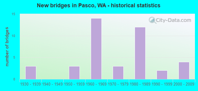
- New bridges - historical statistics
- 31930-1939
- 31950-1959
- 141960-1969
- 31970-1979
- 121980-1989
- 21990-1999
- 42000-2009
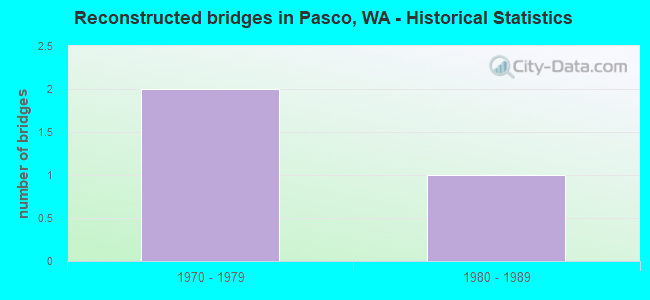
- Reconstructed bridges - Historical Statistics
- 21970-1979
- 11980-1989
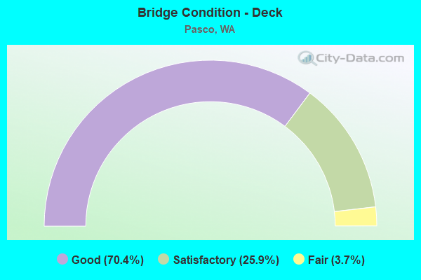
- Bridge Condition - Deck
- 70.4%Good
- 25.9%Satisfactory
- 3.7%Fair
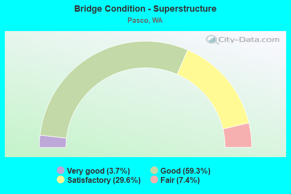
- Bridge Condition - Superstructure
- 3.7%Very good
- 59.3%Good
- 29.6%Satisfactory
- 7.4%Fair
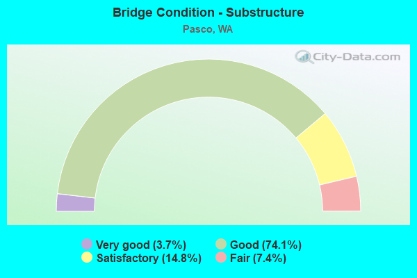
- Bridge Condition - Substructure
- 3.7%Very good
- 74.1%Good
- 14.8%Satisfactory
- 7.4%Fair
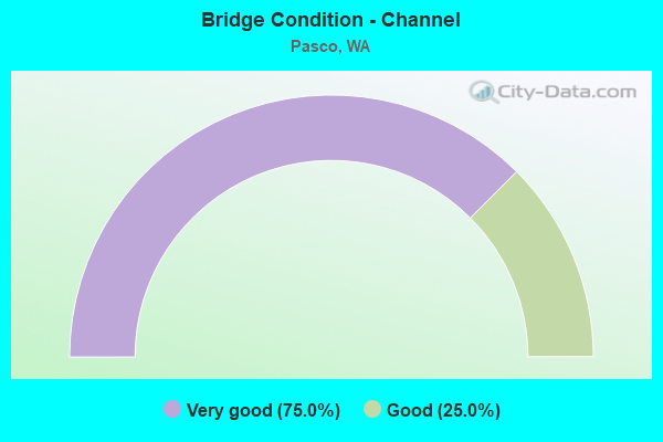
- Bridge Condition - Channel
- 75.0%Very good
- 25.0%Good
Find on map >> Show street view
Structure Number: 3762A, Location: 2.9 E JCT I-182 (Lat: 46.217639, Lng: -119.025000), Route carried "on" structure: US 12, Year Built: 1950, Year Reconstructed: 1988, Status: Open, Structure Length: 53.95m (177.00ft), Average Daily Traffic: 12,841 (year 2019), Truck Traffic: 18%, Average Future Daily Traffic: 16,539 (year 2039), Design Load: HS 20, Features Intersected: SNAKE RIVER & BNRR
Minimum Vertical Clearance: 5.46m (17.91ft), Kilometerpoint: 473.968, Lanes on structure: 2, Base Highway Network: Yes, Owner: State Highway Agency, Approaching Roadway Width: 12.5m (41.0ft), Navigation Control: Yes ( Vertical Clearance: 15.2m (49.9ft), Horizontal Clearance: 121.9m (399.9ft)), Material/Design: Steel continuous, Design/Construction: Truss - Thru, Number Of Spans In Main Unit: 3, Number Of Approach Spans: 10, Length of Maximum Span: 129.5m (424.9ft), Curb-To-Curb Width: 9.7m (31.8ft), Out-to-Out Width: 10.4m (34.1ft)
Condition: Deck: Good, Superstructure: Satisfactory, Substructure: Good, Channel: Very good, Operating Rating: 44.4 metric tons, Method Used To Determine Operating Rating: Load Factor (LF), Inventory Rating: 27.2 metric tons, Method Used To Determine Inventory Rating: Load Factor (LF), Structural Evaluation: Equal to present minimum criteria, Deck Geometry: Meets minimum limits, Underclear: Better than present minimum criteria, Waterway Adequacy: Equal to present desirable criteria, Approach Roadway Alignment: Equal to present desirable criteria, Length Of Structure Improvement: 53.95m (177.00ft), Designated Inspection Frequency: Every 24 months, Critical Feature Inspection Frequency: Every 24 months, Underwater Inspection Frequency: Every 60 months, Inspection Date: July 2020, Critical Feature Inspection Date: July 2020, Underwater Inspection Date: October 2019, Bridge Improvement Cost: $15,222,000, Roadway Improvement Cost: $3,044,000, Total Project Cost: $30,444,000 ( Estimate for 2014), Deck Structure Type: Concrete Cast-file-Place, Wearing Surface/Protective System: Wearing Surface: Monolithic Concrete, Deck Protection: Epoxy Coated Reinforcing
Find on map >> Show street view
Structure Number: 4556A, Location: 0.4 N BENTON CO (Lat: 46.231528, Lng: -119.131917), Route carried "on" structure: US 395, Year Built: 1953, Status: Open, Structure Length: 7.10m (23.29ft), Average Daily Traffic: 26,136 (year 2019), Truck Traffic: 9%, Average Future Daily Traffic: 33,663 (year 2039), Design Load: HS 20, Features Intersected: LEWIS ST
Minimum Vertical Clearance: 30+ m (98+ ft), Kilometerpoint: 31.109, Lanes on structure: 2, Lanes under structure: 3, Base Highway Network: Yes, Owner: State Highway Agency, Approaching Roadway Width: 8.5m (27.9ft), Material/Design: Concrete continuous, Design/Construction: Box Beam or Girders - Multiple, Number Of Spans In Main Unit: 3, Length of Maximum Span: 30.5m (100.1ft), Curb or Sidewalk Widths: Left: 0.2m (0.7ft), Right: 0.2m (0.7ft), Curb-To-Curb Width: 7.9m (25.9ft), Out-to-Out Width: 9.3m (30.5ft)
Condition: Deck: Good, Superstructure: Satisfactory, Substructure: Good, Operating Rating: 89.8 metric tons, Method Used To Determine Operating Rating: Load Factor (LF), Inventory Rating: 59.0 metric tons, Method Used To Determine Inventory Rating: Load Factor (LF), Structural Evaluation: Equal to present minimum criteria, Deck Geometry: High priority of replacement, Underclear: High priority of corrective action, Approach Roadway Alignment: Equal to present minimum criteria, Length Of Structure Improvement: 7.10m (23.29ft), Designated Inspection Frequency: Every 24 months, Inspection Date: Febuary 2020, Bridge Improvement Cost: $1,398,000, Roadway Improvement Cost: $280,000, Total Project Cost: $2,796,000 ( Estimate for 2014), Deck Structure Type: Concrete Cast-file-Place, Wearing Surface/Protective System: Wearing Surface: Bituminous, Membrane: Preformed Fabric
Find on map >> Show street view
Structure Number: 7410A, Location: 7.8 E BENTON CO (Lat: 46.249667, Lng: -119.095056), Route carried "on" structure: Interstate 182, Year Built: 1964, Status: Open, Structure Length: 4.97m (16.31ft), Average Daily Traffic: 27,839 (year 2019), Truck Traffic: 7%, Average Future Daily Traffic: 35,856 (year 2039), Design Load: HS 20, Features Intersected: N 4TH AVE
Minimum Vertical Clearance: 30+ m (98+ ft), Kilometerpoint: 22.145, Lanes on structure: 2, Lanes under structure: 3, Base Highway Network: Yes, Owner: State Highway Agency, Approaching Roadway Width: 12.8m (42.0ft), Skew: 1 degrees, Material/Design: Prestressed concrete, Design/Construction: Stringer/Multi-beam, Number Of Spans In Main Unit: 3, Length of Maximum Span: 17.4m (57.1ft), Curb-To-Curb Width: 12.8m (42.0ft), Out-to-Out Width: 14.6m (47.9ft)
Condition: Deck: Satisfactory, Superstructure: Good, Substructure: Good, Operating Rating: 68.9 metric tons, Method Used To Determine Operating Rating: Load Factor (LF), Inventory Rating: 39.0 metric tons, Method Used To Determine Inventory Rating: Load Factor (LF), Structural Evaluation: Better than present minimum criteria, Deck Geometry: Equal to present desirable criteria, Underclear: High priority of corrective action, Approach Roadway Alignment: Equal to present desirable criteria, Length Of Structure Improvement: 4.97m (16.31ft), Designated Inspection Frequency: Every 24 months, Inspection Date: March 2021, Bridge Improvement Cost: $1,434,000, Roadway Improvement Cost: $287,000, Total Project Cost: $2,869,000 ( Estimate for 2014), Deck Structure Type: Concrete Cast-file-Place, Wearing Surface/Protective System: Wearing Surface: Bituminous, Membrane: Preformed Fabric
Find on map >> Show street view
Structure Number: 7410B, Location: 7.9 E BENTON CO (Lat: 46.249972, Lng: -119.093722), Route carried "on" structure: Interstate 182, Year Built: 1964, Status: Open, Structure Length: 13.90m (45.60ft), Average Daily Traffic: 25,505 (year 2019), Truck Traffic: 15%, Average Future Daily Traffic: 32,850 (year 2039), Design Load: HS 20, Features Intersected: NP RY
Minimum Vertical Clearance: 30+ m (98+ ft), Kilometerpoint: 22.257, Lanes on structure: 2, Base Highway Network: Yes, Owner: State Highway Agency, Approaching Roadway Width: 9.8m (32.2ft), Material/Design: Steel continuous, Design/Construction: Stringer/Multi-beam, Number Of Spans In Main Unit: 4, Length of Maximum Span: 39.0m (128.0ft), Curb-To-Curb Width: 9.1m (29.9ft), Out-to-Out Width: 11.0m (36.1ft)
Condition: Deck: Satisfactory, Superstructure: Good, Substructure: Good, Operating Rating: 49.9 metric tons, Method Used To Determine Operating Rating: Load Factor (LF), Inventory Rating: 29.9 metric tons, Method Used To Determine Inventory Rating: Load Factor (LF), Structural Evaluation: Better than present minimum criteria, Deck Geometry: Meets minimum limits, Underclear: Meets minimum limits, Approach Roadway Alignment: Equal to present desirable criteria, Length Of Structure Improvement: 13.90m (45.60ft), Designated Inspection Frequency: Every 24 months, Inspection Date: April 2021, Bridge Improvement Cost: $3,101,000, Roadway Improvement Cost: $620,000, Total Project Cost: $6,202,000 ( Estimate for 2014), Deck Structure Type: Concrete Cast-file-Place, Wearing Surface/Protective System: Wearing Surface: Bituminous, Membrane: Preformed Fabric
Find on map >> Show street view
Structure Number: 7819A, Location: 0.7 N BENTON CO (Lat: 46.234194, Lng: -119.132333), Route carried "on" structure: City street , Year Built: 1966, Status: Open, Structure Length: 7.68m (25.20ft), Average Daily Traffic: 9,960 (year 2012), Truck Traffic: 7%, Average Future Daily Traffic: 13,546 (year 2036), Design Load: HS 20, Features Intersected: US 395, Facility Carried by Structure: SYLVESTER ST
Minimum Vertical Clearance: 30+ m (98+ ft), Kilometerpoint: 2.929, Lanes on structure: 2, Lanes under structure: 5, Owner: State Highway Agency, Approaching Roadway Width: 9.8m (32.2ft), Skew: 1 degrees, Material/Design: Prestressed concrete continuous, Design/Construction: Stringer/Multi-beam, Number Of Spans In Main Unit: 5, Length of Maximum Span: 17.4m (57.1ft), Curb or Sidewalk Widths: Left: 0.5m (1.6ft), Right: 0.9m (3.0ft), Curb-To-Curb Width: 8.5m (27.9ft), Out-to-Out Width: 10.5m (34.4ft)
Condition: Deck: Good, Superstructure: Good, Substructure: Good, Operating Rating: 58.0 metric tons, Method Used To Determine Operating Rating: Load Factor (LF), Inventory Rating: 34.5 metric tons, Method Used To Determine Inventory Rating: Load Factor (LF), Structural Evaluation: Better than present minimum criteria, Deck Geometry: Meets minimum limits, Underclear: Somewhat better than minimum adequacy, Approach Roadway Alignment: Equal to present desirable criteria, Length Of Structure Improvement: 7.68m (25.20ft), Designated Inspection Frequency: Every 24 months, Inspection Date: April 2021, Bridge Improvement Cost: $1,714,000, Roadway Improvement Cost: $343,000, Total Project Cost: $3,427,000 ( Estimate for 2014), Deck Structure Type: Concrete Cast-file-Place, Wearing Surface/Protective System: Wearing Surface: Latex Concrete
Find on map >> Show street view
Structure Number: 7819B, Location: 1.2 N BENTON CO (Lat: 46.241519, Lng: -119.129011), Route carried "on" structure: City street , Year Built: 1966, Status: Open, Structure Length: 3.38m (11.09ft), Average Daily Traffic: 16,529 (year 2012), Truck Traffic: 7%, Average Future Daily Traffic: 23,670 (year 2036), Design Load: HS 20, Features Intersected: US 395, Facility Carried by Structure: COURT ST
Minimum Vertical Clearance: 30+ m (98+ ft), Kilometerpoint: 0.209, Lanes on structure: 4, Lanes under structure: 5, Base Highway Network: Yes, Owner: State Highway Agency, Approaching Roadway Width: 17.1m (56.1ft), Skew: 1 degrees, Material/Design: Prestressed concrete, Design/Construction: Stringer/Multi-beam, Number Of Spans In Main Unit: 1, Length of Maximum Span: 32.3m (106.0ft), Curb or Sidewalk Widths: Left: 0.0m, Right: 0.9m (3.0ft), Curb-To-Curb Width: 16.2m (53.1ft), Out-to-Out Width: 17.8m (58.4ft)
Condition: Deck: Good, Superstructure: Fair, Substructure: Good, Operating Rating: 49.9 metric tons, Method Used To Determine Operating Rating: Load Factor (LF), Inventory Rating: 21.8 metric tons, Method Used To Determine Inventory Rating: Load Factor (LF), Structural Evaluation: Somewhat better than minimum adequacy, Deck Geometry: Meets minimum limits, Underclear: Somewhat better than minimum adequacy, Approach Roadway Alignment: Equal to present desirable criteria, Length Of Structure Improvement: 3.38m (11.09ft), Designated Inspection Frequency: Every 24 months, Inspection Date: September 2021, Bridge Improvement Cost: $1,288,000, Roadway Improvement Cost: $258,000, Total Project Cost: $2,575,000 ( Estimate for 2014), Deck Structure Type: Concrete Cast-file-Place, Wearing Surface/Protective System: Wearing Surface: Latex Concrete
Find on map >> Show street view
Structure Number: 8422B, Location: 6.8 E BENTON CO (Lat: 46.248806, Lng: -119.117361), Route carried "on" structure: Interstate 182, Year Built: 1968, Status: Open, Structure Length: 4.91m (16.11ft), Average Daily Traffic: 18,329 (year 2019), Truck Traffic: 7%, Average Future Daily Traffic: 23,607 (year 2039), Design Load: HS 20+Mod, Features Intersected: N 20TH AVE
Minimum Vertical Clearance: 30+ m (98+ ft), Kilometerpoint: 20.406, Lanes on structure: 2, Lanes under structure: 5, Base Highway Network: Yes, Owner: State Highway Agency, Approaching Roadway Width: 11.6m (38.1ft), Material/Design: Prestressed concrete continuous, Design/Construction: Stringer/Multi-beam, Number Of Spans In Main Unit: 3, Length of Maximum Span: 23.5m (77.1ft), Curb or Sidewalk Widths: Left: 0.2m (0.7ft), Right: 0.2m (0.7ft), Curb-To-Curb Width: 11.6m (38.1ft), Out-to-Out Width: 12.6m (41.3ft)
Condition: Deck: Good, Superstructure: Satisfactory, Substructure: Good, Operating Rating: 78.9 metric tons, Method Used To Determine Operating Rating: Load Factor (LF), Inventory Rating: 46.3 metric tons, Method Used To Determine Inventory Rating: Load Factor (LF), Structural Evaluation: Equal to present minimum criteria, Deck Geometry: Equal to present minimum criteria, Underclear: Meets minimum limits, Approach Roadway Alignment: Equal to present desirable criteria, Length Of Structure Improvement: 4.91m (16.11ft), Designated Inspection Frequency: Every 24 months, Inspection Date: March 2021, Bridge Improvement Cost: $1,288,000, Roadway Improvement Cost: $258,000, Total Project Cost: $2,576,000 ( Estimate for 2014), Deck Structure Type: Concrete Cast-file-Place, Wearing Surface/Protective System: Wearing Surface: Bituminous, Membrane: Preformed Fabric
Find on map >> Show street view
Structure Number: 8422C, Location: 7.8 E BENTON CO (Lat: 46.249858, Lng: -119.095128), Route carried "on" structure: Interstate 182, Year Built: 1968, Status: Open, Structure Length: 5.39m (17.68ft), Average Daily Traffic: 27,839 (year 2019), Truck Traffic: 7%, Average Future Daily Traffic: 35,856 (year 2039), Design Load: HS 20+Mod, Features Intersected: N 4TH AVE
Minimum Vertical Clearance: 30+ m (98+ ft), Kilometerpoint: 22.145, Lanes on structure: 2, Lanes under structure: 3, Base Highway Network: Yes, Owner: State Highway Agency, Approaching Roadway Width: 11.6m (38.1ft), Skew: 1 degrees, Material/Design: Prestressed concrete continuous, Design/Construction: Stringer/Multi-beam, Number Of Spans In Main Unit: 3, Length of Maximum Span: 19.5m (64.0ft), Curb or Sidewalk Widths: Left: 0.2m (0.7ft), Right: 0.2m (0.7ft), Curb-To-Curb Width: 11.6m (38.1ft), Out-to-Out Width: 12.5m (41.0ft)
Condition: Deck: Good, Superstructure: Good, Substructure: Good, Operating Rating: 59.9 metric tons, Method Used To Determine Operating Rating: Load Factor (LF), Inventory Rating: 35.4 metric tons, Method Used To Determine Inventory Rating: Load Factor (LF), Structural Evaluation: Better than present minimum criteria, Deck Geometry: Equal to present minimum criteria, Underclear: High priority of corrective action, Approach Roadway Alignment: Equal to present desirable criteria, Length Of Structure Improvement: 5.39m (17.68ft), Designated Inspection Frequency: Every 48 months, Inspection Date: March 2019, Bridge Improvement Cost: $1,416,000, Roadway Improvement Cost: $283,000, Total Project Cost: $2,832,000 ( Estimate for 2014), Deck Structure Type: Concrete Cast-file-Place, Wearing Surface/Protective System: Wearing Surface: Bituminous, Membrane: Preformed Fabric
Find on map >> Show street view
Structure Number: 8422D, Location: 7.9 E BENTON CO (Lat: 46.250083, Lng: -119.093750), Route carried "on" structure: Interstate 182, Year Built: 1968, Status: Open, Structure Length: 13.90m (45.60ft), Average Daily Traffic: 25,505 (year 2019), Truck Traffic: 15%, Average Future Daily Traffic: 32,850 (year 2039), Design Load: HS 20+Mod, Features Intersected: NP RY
Minimum Vertical Clearance: 30+ m (98+ ft), Kilometerpoint: 22.257, Lanes on structure: 2, Base Highway Network: Yes, Owner: State Highway Agency, Approaching Roadway Width: 15.8m (51.8ft), Material/Design: Steel continuous, Design/Construction: Stringer/Multi-beam, Number Of Spans In Main Unit: 4, Length of Maximum Span: 39.0m (128.0ft), Curb or Sidewalk Widths: Left: 0.2m (0.7ft), Right: 0.2m (0.7ft), Curb-To-Curb Width: 11.6m (38.1ft), Out-to-Out Width: 12.6m (41.3ft)
Condition: Deck: Good, Superstructure: Good, Substructure: Satisfactory, Operating Rating: 43.5 metric tons, Method Used To Determine Operating Rating: Load Factor (LF), Inventory Rating: 25.4 metric tons, Method Used To Determine Inventory Rating: Load Factor (LF), Structural Evaluation: Equal to present minimum criteria, Deck Geometry: Equal to present minimum criteria, Underclear: Meets minimum limits, Approach Roadway Alignment: Equal to present desirable criteria, Length Of Structure Improvement: 13.90m (45.60ft), Designated Inspection Frequency: Every 24 months, Inspection Date: April 2021, Bridge Improvement Cost: $4,925,000, Roadway Improvement Cost: $985,000, Total Project Cost: $9,850,000 ( Estimate for 2014), Deck Structure Type: Concrete Cast-file-Place, Wearing Surface/Protective System: Wearing Surface: Bituminous, Membrane: Preformed Fabric
Find on map >> Show street view
Structure Number: 9306A, Location: 3.7 N BENTON CO (Lat: 46.251361, Lng: -119.082611), Route carried "on" structure: US 395, Year Built: 1972, Status: Open, Structure Length: 10.12m (33.20ft), Average Daily Traffic: 19,362 (year 2019), Truck Traffic: 23%, Average Future Daily Traffic: 24,938 (year 2039), Design Load: HS 20+Mod, Features Intersected: US 12, I-182, US 395
Minimum Vertical Clearance: 30+ m (98+ ft), Kilometerpoint: 36.564, Lanes on structure: 6, Lanes under structure: 8, Base Highway Network: Yes, Owner: State Highway Agency, Approaching Roadway Width: 29.3m (96.1ft), Skew: 20 degrees, Material/Design: Concrete continuous, Design/Construction: Box Beam or Girders - Multiple, Number Of Spans In Main Unit: 3, Length of Maximum Span: 41.5m (136.2ft), Curb-To-Curb Width: 29.3m (96.1ft), Out-to-Out Width: 30.2m (99.1ft)
Condition: Deck: Satisfactory, Superstructure: Good, Substructure: Satisfactory, Operating Rating: 59.0 metric tons, Method Used To Determine Operating Rating: Load Factor (LF), Inventory Rating: 35.4 metric tons, Method Used To Determine Inventory Rating: Load Factor (LF), Structural Evaluation: Equal to present minimum criteria, Deck Geometry: Better than present minimum criteria, Underclear: Equal to present minimum criteria, Approach Roadway Alignment: Equal to present desirable criteria, Length Of Structure Improvement: 10.12m (33.20ft), Designated Inspection Frequency: Every 24 months, Inspection Date: Febuary 2020, Bridge Improvement Cost: $6,507,000, Roadway Improvement Cost: $1,301,000, Total Project Cost: $13,014,000 ( Estimate for 2014), Deck Structure Type: Concrete Cast-file-Place, Wearing Surface/Protective System: Wearing Surface: Monolithic Concrete
Find on map >> Show street view
Structure Number: 12236A, Location: 1.3 E BENTON CO (Lat: 46.275833, Lng: -119.221500), Route carried "on" structure: City street , Year Built: 1983, Status: Open, Structure Length: 10.67m (35.01ft), Average Daily Traffic: 13,898 (year 2012), Truck Traffic: 5%, Design Load: HS 20, Features Intersected: I-182, Facility Carried by Structure: CNTY RD 100
Minimum Vertical Clearance: 30+ m (98+ ft), Kilometerpoint: 0.145, Lanes on structure: 4, Lanes under structure: 7, Owner: State Highway Agency, Approaching Roadway Width: 16.8m (55.1ft), Skew: 1 degrees, Material/Design: Prestressed concrete continuous, Design/Construction: Box Beam or Girders - Multiple, Number Of Spans In Main Unit: 2, Length of Maximum Span: 55.2m (181.1ft), Curb-To-Curb Width: 16.8m (55.1ft), Out-to-Out Width: 17.7m (58.1ft)
Condition: Deck: Good, Superstructure: Good, Substructure: Good, Operating Rating: 54.4 metric tons, Method Used To Determine Operating Rating: Load Factor (LF), Inventory Rating: 32.7 metric tons, Method Used To Determine Inventory Rating: Load Factor (LF), Structural Evaluation: Better than present minimum criteria, Deck Geometry: Somewhat better than minimum adequacy, Underclear: Better than present minimum criteria, Approach Roadway Alignment: Equal to present desirable criteria, Length Of Structure Improvement: 10.67m (35.01ft), Designated Inspection Frequency: Every 24 months, Inspection Date: Febuary 2020, Bridge Improvement Cost: $3,990,000, Roadway Improvement Cost: $798,000, Total Project Cost: $7,980,000 ( Estimate for 2014), Deck Structure Type: Concrete Cast-file-Place, Wearing Surface/Protective System: Wearing Surface: Monolithic Concrete, Deck Protection: Epoxy Coated Reinforcing
Find on map >> Show street view
Structure Number: 12236B, Location: 4.9 E BENTON CO (Lat: 46.256833, Lng: -119.154361), Route carried "on" structure: Interstate 182, Year Built: 1984, Status: Open, Structure Length: 3.96m (12.99ft), Average Daily Traffic: 29,180 (year 2019), Truck Traffic: 7%, Average Future Daily Traffic: 37,583 (year 2039), Design Load: HS 20, Features Intersected: ARGENT ROAD
Minimum Vertical Clearance: 30+ m (98+ ft), Kilometerpoint: 17.381, Lanes on structure: 3, Lanes under structure: 2, Base Highway Network: Yes, Owner: State Highway Agency, Approaching Roadway Width: 15.8m (51.8ft), Skew: 3 degrees, Material/Design: Prestressed concrete, Design/Construction: Stringer/Multi-beam, Number Of Spans In Main Unit: 1, Length of Maximum Span: 37.8m (124.0ft), Curb-To-Curb Width: 15.8m (51.8ft), Out-to-Out Width: 16.8m (55.1ft)
Condition: Deck: Good, Superstructure: Good, Substructure: Good, Operating Rating: 58.0 metric tons, Method Used To Determine Operating Rating: Load Factor (LF), Inventory Rating: 33.6 metric tons, Method Used To Determine Inventory Rating: Load Factor (LF), Structural Evaluation: Better than present minimum criteria, Deck Geometry: Somewhat better than minimum adequacy, Underclear: Meets minimum limits, Approach Roadway Alignment: Equal to present desirable criteria, Length Of Structure Improvement: 3.96m (12.99ft), Designated Inspection Frequency: Every 24 months, Inspection Date: March 2021, Bridge Improvement Cost: $1,404,000, Roadway Improvement Cost: $281,000, Total Project Cost: $2,808,000 ( Estimate for 2014), Deck Structure Type: Concrete Cast-file-Place, Wearing Surface/Protective System: Wearing Surface: Monolithic Concrete, Deck Protection: Epoxy Coated Reinforcing
Find on map >> Show street view
Structure Number: 12236C, Location: 3.2 E BENTON CO (Lat: 46.265028, Lng: -119.182222), Route carried "on" structure: City street , Year Built: 1983, Status: Open, Structure Length: 11.64m (38.19ft), Average Daily Traffic: 25,433 (year 2012), Truck Traffic: 5%, Design Load: HS 20, Features Intersected: I-182, Facility Carried by Structure: COUNTY ROAD 68
Minimum Vertical Clearance: 30+ m (98+ ft), Kilometerpoint: 0.129, Lanes on structure: 4, Lanes under structure: 8, Owner: State Highway Agency, Approaching Roadway Width: 19.5m (64.0ft), Skew: 3 degrees, Material/Design: Prestressed concrete continuous, Design/Construction: Box Beam or Girders - Multiple, Number Of Spans In Main Unit: 2, Length of Maximum Span: 57.6m (189.0ft), Curb-To-Curb Width: 19.5m (64.0ft), Out-to-Out Width: 20.4m (66.9ft)
Condition: Deck: Good, Superstructure: Good, Substructure: Good, Operating Rating: 46.3 metric tons, Method Used To Determine Operating Rating: Load Factor (LF), Inventory Rating: 27.2 metric tons, Method Used To Determine Inventory Rating: Load Factor (LF), Structural Evaluation: Equal to present minimum criteria, Deck Geometry: Better than present minimum criteria, Underclear: Meets minimum limits, Approach Roadway Alignment: Equal to present desirable criteria, Length Of Structure Improvement: 11.64m (38.19ft), Designated Inspection Frequency: Every 24 months, Inspection Date: March 2021, Bridge Improvement Cost: $5,042,000, Roadway Improvement Cost: $1,008,000, Total Project Cost: $10,085,000 ( Estimate for 2014), Deck Structure Type: Concrete Cast-file-Place, Wearing Surface/Protective System: Wearing Surface: Monolithic Concrete, Deck Protection: Epoxy Coated Reinforcing
Find on map >> Show street view
Structure Number: 12236E, Location: 7.3 E JCT SR 240 (Lat: 46.249361, Lng: -119.126944), Route carried "on" structure: US 395, Year Built: 1983, Status: Open, Structure Length: 9.94m (32.61ft), Average Daily Traffic: 14,406 (year 2019), Truck Traffic: 9%, Average Future Daily Traffic: 18,554 (year 2039), Design Load: HS 20, Features Intersected: I-182
Minimum Vertical Clearance: 30+ m (98+ ft), Kilometerpoint: 33.056, Lanes on structure: 1, Lanes under structure: 6, Base Highway Network: Yes, Owner: State Highway Agency, Approaching Roadway Width: 8.5m (27.9ft), Material/Design: Prestressed concrete continuous, Design/Construction: Box Beam or Girders - Multiple, Number Of Spans In Main Unit: 2, Length of Maximum Span: 51.2m (168.0ft), Curb-To-Curb Width: 7.9m (25.9ft), Out-to-Out Width: 8.8m (28.9ft)
Condition: Deck: Good, Superstructure: Good, Substructure: Good, Operating Rating: 59.0 metric tons, Method Used To Determine Operating Rating: Load Factor (LF), Inventory Rating: 34.5 metric tons, Method Used To Determine Inventory Rating: Load Factor (LF), Structural Evaluation: Better than present minimum criteria, Deck Geometry: High priority of corrective action, Underclear: Meets minimum limits, Approach Roadway Alignment: Equal to present desirable criteria, Length Of Structure Improvement: 9.94m (32.61ft), Designated Inspection Frequency: Every 24 months, Inspection Date: March 2021, Bridge Improvement Cost: $1,956,000, Roadway Improvement Cost: $391,000, Total Project Cost: $3,912,000 ( Estimate for 2014), Deck Structure Type: Concrete Cast-file-Place, Wearing Surface/Protective System: Wearing Surface: Monolithic Concrete, Deck Protection: Epoxy Coated Reinforcing
Find on map >> Show street view
Structure Number: 12236F, Location: 6.8 E BENTON CO (Lat: 46.248417, Lng: -119.117389), Route carried "on" structure: Interstate 182, Year Built: 1968, Year Reconstructed: 1984, Status: Open, Structure Length: 4.91m (16.11ft), Average Daily Traffic: 18,329 (year 2019), Truck Traffic: 7%, Average Future Daily Traffic: 23,607 (year 2039), Design Load: HS 20, Features Intersected: N 20TH AVE
Minimum Vertical Clearance: 30+ m (98+ ft), Kilometerpoint: 20.406, Lanes on structure: 4, Lanes under structure: 5, Base Highway Network: Yes, Owner: State Highway Agency, Approaching Roadway Width: 25.0m (82.0ft), Material/Design: Prestressed concrete continuous, Design/Construction: Stringer/Multi-beam, Number Of Spans In Main Unit: 3, Length of Maximum Span: 23.5m (77.1ft), Curb-To-Curb Width: 24.5m (80.4ft), Out-to-Out Width: 27.2m (89.2ft)
Condition: Deck: Good, Superstructure: Good, Substructure: Good, Operating Rating: 76.2 metric tons, Method Used To Determine Operating Rating: Load Factor (LF), Inventory Rating: 45.4 metric tons, Method Used To Determine Inventory Rating: Load Factor (LF), Structural Evaluation: Better than present minimum criteria, Deck Geometry: Superior to present desirable criteria, Underclear: Meets minimum limits, Approach Roadway Alignment: Equal to present desirable criteria, Length Of Structure Improvement: 4.91m (16.11ft), Designated Inspection Frequency: Every 48 months, Inspection Date: March 2019, Bridge Improvement Cost: $2,705,000, Roadway Improvement Cost: $541,000, Total Project Cost: $5,410,000 ( Estimate for 2014), Deck Structure Type: Concrete Cast-file-Place, Wearing Surface/Protective System: Wearing Surface: Bituminous, Membrane: Preformed Fabric
Find on map >> Show street view
Structure Number: 12236G, Location: 4.9 E BENTON CO (Lat: 46.257056, Lng: -119.154083), Route carried "on" structure: Interstate 182, Year Built: 1984, Status: Open, Structure Length: 4.45m (14.60ft), Average Daily Traffic: 29,180 (year 2019), Truck Traffic: 7%, Average Future Daily Traffic: 37,583 (year 2039), Design Load: HS 20, Features Intersected: ARGENT ROAD
Minimum Vertical Clearance: 30+ m (98+ ft), Kilometerpoint: 17.397, Lanes on structure: 3, Lanes under structure: 2, Base Highway Network: Yes, Owner: State Highway Agency, Approaching Roadway Width: 15.8m (51.8ft), Skew: 4 degrees, Material/Design: Prestressed concrete, Design/Construction: Stringer/Multi-beam, Number Of Spans In Main Unit: 1, Length of Maximum Span: 44.5m (146.0ft), Curb-To-Curb Width: 15.8m (51.8ft), Out-to-Out Width: 16.8m (55.1ft)
Condition: Deck: Good, Superstructure: Satisfactory, Substructure: Good, Operating Rating: 68.0 metric tons, Method Used To Determine Operating Rating: Load Factor (LF), Inventory Rating: 39.9 metric tons, Method Used To Determine Inventory Rating: Load Factor (LF), Structural Evaluation: Equal to present minimum criteria, Deck Geometry: Somewhat better than minimum adequacy, Underclear: Meets minimum limits, Approach Roadway Alignment: Equal to present desirable criteria, Length Of Structure Improvement: 4.45m (14.60ft), Designated Inspection Frequency: Every 24 months, Inspection Date: March 2021, Bridge Improvement Cost: $1,577,000, Roadway Improvement Cost: $315,000, Total Project Cost: $3,154,000 ( Estimate for 2014), Deck Structure Type: Concrete Cast-file-Place, Wearing Surface/Protective System: Wearing Surface: Monolithic Concrete, Deck Protection: Epoxy Coated Reinforcing
Find on map >> Show street view
Structure Number: 12236H, Location: 1.7 N BENTON CO (Lat: 46.248444, Lng: -119.126111), Route carried "on" structure: US 395, Year Built: 1983, Status: Open, Structure Length: 9.36m (30.71ft), Average Daily Traffic: 14,406 (year 2019), Truck Traffic: 9%, Average Future Daily Traffic: 18,554 (year 2039), Design Load: HS 20, Features Intersected: I-182
Minimum Vertical Clearance: 30+ m (98+ ft), Kilometerpoint: 33.056, Lanes on structure: 2, Lanes under structure: 6, Base Highway Network: Yes, Owner: State Highway Agency, Approaching Roadway Width: 11.6m (38.1ft), Material/Design: Prestressed concrete continuous, Design/Construction: Box Beam or Girders - Multiple, Number Of Spans In Main Unit: 2, Length of Maximum Span: 47.9m (157.2ft), Curb-To-Curb Width: 11.6m (38.1ft), Out-to-Out Width: 12.5m (41.0ft)
Condition: Deck: Good, Superstructure: Good, Substructure: Good, Operating Rating: 54.4 metric tons, Method Used To Determine Operating Rating: Load Factor (LF), Inventory Rating: 32.7 metric tons, Method Used To Determine Inventory Rating: Load Factor (LF), Structural Evaluation: Better than present minimum criteria, Deck Geometry: Equal to present minimum criteria, Underclear: Meets minimum limits, Approach Roadway Alignment: Equal to present desirable criteria, Length Of Structure Improvement: 9.36m (30.71ft), Designated Inspection Frequency: Every 24 months, Inspection Date: March 2021, Bridge Improvement Cost: $2,456,000, Roadway Improvement Cost: $491,000, Total Project Cost: $4,912,000 ( Estimate for 2014), Deck Structure Type: Concrete Cast-file-Place, Wearing Surface/Protective System: Wearing Surface: Monolithic Concrete, Deck Protection: Epoxy Coated Reinforcing
Find on map >> Show street view
Structure Number: 12236I, Location: 4.9 E BENTON CO (Lat: 46.257028, Lng: -119.154611), Route carried "on" structure: Interstate 182, Year Built: 1984, Status: Open, Structure Length: 0.82m (2.69ft), Average Daily Traffic: 58,360 (year 2019), Truck Traffic: 7%, Average Future Daily Traffic: 75,167 (year 2039), Features Intersected: FCID CANAL
Minimum Vertical Clearance: 30+ m (98+ ft), Kilometerpoint: 17.349, Lanes on structure: 6, Base Highway Network: Yes, Owner: State Highway Agency, Approaching Roadway Width: 31.7m (104.0ft), Skew: 5 degrees, Material/Design: Steel, Design/Construction: Culvert, Number Of Spans In Main Unit: 1, Length of Maximum Span: 8.2m (26.9ft)
Condition: Channel: Very good, Culverts: Very good, Operating Rating: 89.8 metric tons, Method Used To Determine Operating Rating: Load Factor (LF), Inventory Rating: 89.8 metric tons, Method Used To Determine Inventory Rating: Load Factor (LF), Structural Evaluation: Equal to present desirable criteria, Waterway Adequacy: Equal to present desirable criteria, Approach Roadway Alignment: Equal to present desirable criteria, Length Of Structure Improvement: 0.82m (2.69ft), Designated Inspection Frequency: Every 48 months, Inspection Date: September 2019, Bridge Improvement Cost: $572,000, Roadway Improvement Cost: $114,000, Total Project Cost: $1,145,000 ( Estimate for 2014)
Find on map >> Show street view
Structure Number: 12800A, Location: 2.9 E JCT I-182 (Lat: 46.217389, Lng: -119.025222), Route carried "on" structure: US 12, Year Built: 1986, Status: Open, Structure Length: 54.25m (177.99ft), Average Daily Traffic: 12,841 (year 2019), Truck Traffic: 18%, Average Future Daily Traffic: 16,539 (year 2039), Design Load: HS 20+Mod, Features Intersected: SNAKE R. & BN RY
Minimum Vertical Clearance: 5.87m (19.26ft), Kilometerpoint: 473.968, Lanes on structure: 2, Base Highway Network: Yes, Owner: State Highway Agency, Approaching Roadway Width: 12.2m (40.0ft), Navigation Control: Yes ( Vertical Clearance: 19.2m (63.0ft), Horizontal Clearance: 129.5m (424.9ft)), Material/Design: Steel continuous, Design/Construction: Truss - Thru, Number Of Spans In Main Unit: 3, Number Of Approach Spans: 7, Length of Maximum Span: 129.5m (424.9ft), Curb or Sidewalk Widths: Left: 0.0m, Right: 1.5m (4.9ft), Curb-To-Curb Width: 11.6m (38.1ft), Out-to-Out Width: 14.7m (48.2ft)
Condition: Deck: Satisfactory, Superstructure: Fair, Substructure: Satisfactory, Channel: Very good, Operating Rating: 37.2 metric tons, Method Used To Determine Operating Rating: Load Factor (LF), Inventory Rating: 21.8 metric tons, Method Used To Determine Inventory Rating: Load Factor (LF), Structural Evaluation: Somewhat better than minimum adequacy, Deck Geometry: Equal to present minimum criteria, Underclear: Superior to present desirable criteria, Waterway Adequacy: Equal to present desirable criteria, Approach Roadway Alignment: Equal to present desirable criteria, Length Of Structure Improvement: 54.25m (177.99ft), Designated Inspection Frequency: Every 24 months, Critical Feature Inspection Frequency: Every 24 months, Underwater Inspection Frequency: Every 60 months, Inspection Date: July 2020, Critical Feature Inspection Date: July 2020, Underwater Inspection Date: October 2019, Bridge Improvement Cost: $14,952,000, Roadway Improvement Cost: $2,990,000, Total Project Cost: $29,904,000 ( Estimate for 2014), Deck Structure Type: Concrete Cast-file-Place, Wearing Surface/Protective System: Wearing Surface: Monolithic Concrete, Deck Protection: Epoxy Coated Reinforcing
Find on map >> Show street view
Structure Number: 14916A, Location: 0.7 E JCT I-182 (Lat: 46.239278, Lng: -119.057250), Route carried "on" structure: City street , Year Built: 1997, Status: Open, Structure Length: 8.23m (27.00ft), Average Daily Traffic: 5,313 (year 2012), Truck Traffic: 19%, Average Future Daily Traffic: 7,608 (year 2036), Design Load: HS 25 or greater, Features Intersected: US 12, Facility Carried by Structure: LEWIS S/KAHLOTUS R
Minimum Vertical Clearance: 30+ m (98+ ft), Kilometerpoint: 0.193, Lanes on structure: 2, Lanes under structure: 6, Base Highway Network: Yes, Owner: State Highway Agency, Approaching Roadway Width: 12.8m (42.0ft), Skew: 1 degrees, Material/Design: Prestressed concrete continuous, Design/Construction: Stringer/Multi-beam, Number Of Spans In Main Unit: 2, Length of Maximum Span: 39.9m (130.9ft), Curb-To-Curb Width: 12.2m (40.0ft), Out-to-Out Width: 13.1m (43.0ft)
Condition: Deck: Good, Superstructure: Satisfactory, Substructure: Good, Operating Rating: 89.8 metric tons, Method Used To Determine Operating Rating: Load Factor (LF), Inventory Rating: 43.5 metric tons, Method Used To Determine Inventory Rating: Load Factor (LF), Structural Evaluation: Equal to present minimum criteria, Deck Geometry: Somewhat better than minimum adequacy, Underclear: Equal to present minimum criteria, Approach Roadway Alignment: Equal to present desirable criteria, Length Of Structure Improvement: 8.23m (27.00ft), Designated Inspection Frequency: Every 24 months, Inspection Date: May 2021, Bridge Improvement Cost: $2,376,000, Roadway Improvement Cost: $475,000, Total Project Cost: $4,752,000 ( Estimate for 2014), Deck Structure Type: Concrete Cast-file-Place, Wearing Surface/Protective System: Wearing Surface: Monolithic Concrete, Deck Protection: Epoxy Coated Reinforcing
Find on map >> Show street view
Structure Number: 16416A, Location: 1.1 N JCT I-182 (Lat: 46.265000, Lng: -119.087500), Route carried "on" structure: City street , Year Built: 2003, Status: Open, Structure Length: 11.58m (37.99ft), Average Daily Traffic: 4,813 (year 2012), Truck Traffic: 8%, Design Load: HL 93, Features Intersected: US 395, Facility Carried by Structure: KARTCHNER ST
Minimum Vertical Clearance: 30+ m (98+ ft), Kilometerpoint: 0.290, Lanes on structure: 2, Lanes under structure: 6, Owner: State Highway Agency, Approaching Roadway Width: 12.2m (40.0ft), Skew: 1 degrees, Material/Design: Prestressed concrete continuous, Design/Construction: Stringer/Multi-beam, Number Of Spans In Main Unit: 4, Length of Maximum Span: 38.1m (125.0ft), Curb-To-Curb Width: 12.2m (40.0ft), Out-to-Out Width: 13.1m (43.0ft)
Condition: Deck: Good, Superstructure: Good, Substructure: Good, Operating Rating: 89.8 metric tons, Method Used To Determine Operating Rating: Load Factor (LF), Inventory Rating: 67.1 metric tons, Method Used To Determine Inventory Rating: Load Factor (LF), Structural Evaluation: Better than present minimum criteria, Deck Geometry: Equal to present minimum criteria, Underclear: Better than present minimum criteria, Approach Roadway Alignment: Equal to present desirable criteria, Length Of Structure Improvement: 11.58m (37.99ft), Designated Inspection Frequency: Every 24 months, Inspection Date: Febuary 2020, Bridge Improvement Cost: $3,192,000, Roadway Improvement Cost: $638,000, Total Project Cost: $6,384,000 ( Estimate for 2014), Deck Structure Type: Concrete Cast-file-Place, Wearing Surface/Protective System: Wearing Surface: Monolithic Concrete, Deck Protection: Epoxy Coated Reinforcing
Find on map >> Show street view
Structure Number: 200395, Location: 0.9 N FRANKLIN CO (Lat: 46.222083, Lng: -119.092583), Route carried "on" structure: State highway 397, Year Built: 2007, Status: Open, Structure Length: 7.28m (23.88ft), Average Daily Traffic: 8,433 (year 2019), Truck Traffic: 13%, Average Future Daily Traffic: 10,861 (year 2039), Design Load: HL 93, Features Intersected: SOUTH 4TH AVE / BNSF RR
Minimum Vertical Clearance: 30+ m (98+ ft), Kilometerpoint: 30.948, Lanes on structure: 2, Lanes under structure: 2, Base Highway Network: Yes, Owner: State Highway Agency, Approaching Roadway Width: 12.2m (40.0ft), Material/Design: Prestressed concrete continuous, Design/Construction: Stringer/Multi-beam, Number Of Spans In Main Unit: 2, Length of Maximum Span: 35.1m (115.2ft), Curb or Sidewalk Widths: Left: 0.0m, Right: 2.1m (6.9ft), Curb-To-Curb Width: 12.2m (40.0ft), Out-to-Out Width: 15.0m (49.2ft)
Condition: Deck: Good, Superstructure: Good, Substructure: Good, Operating Rating: 51.7 metric tons, Method Used To Determine Operating Rating: Load Factor (LF), Inventory Rating: 30.8 metric tons, Method Used To Determine Inventory Rating: Load Factor (LF), Structural Evaluation: Better than present minimum criteria, Deck Geometry: Somewhat better than minimum adequacy, Underclear: Superior to present desirable criteria, Approach Roadway Alignment: Equal to present desirable criteria, Length Of Structure Improvement: 7.28m (23.88ft), Designated Inspection Frequency: Every 24 months, Inspection Date: April 2021, Bridge Improvement Cost: $2,008,000, Roadway Improvement Cost: $402,000, Total Project Cost: $4,015,000 ( Estimate for 2014), Deck Structure Type: Concrete Cast-file-Place, Wearing Surface/Protective System: Wearing Surface: Monolithic Concrete, Deck Protection: Epoxy Coated Reinforcing
Find on map >> Show street view
Structure Number: 81624, Location: 0.74S JCT R 916 (Lat: 46.347558, Lng: -119.114383), Route carried "on" structure: County highway 9010, Year Built: 1964, Year Reconstructed: 1984, Status: Open, Structure Length: 2.13m (6.99ft), Average Daily Traffic: 3,979 (year 2018), Truck Traffic: 32%, Average Future Daily Traffic: 5,970 (year 2038), Design Load: H 20, Features Intersected: ESQUATZEL CANAL, Facility Carried by Structure: GLADE NORTH
Minimum Vertical Clearance: 30+ m (98+ ft), Kilometerpoint: 0.001, Lanes on structure: 2, Owner: County Highway Agency, Approaching Roadway Width: 8.8m (28.9ft), Material/Design: Steel, Design/Construction: Girder and Floorbeam System, Number Of Spans In Main Unit: 1, Length of Maximum Span: 21.3m (69.9ft), Curb-To-Curb Width: 12.2m (40.0ft), Out-to-Out Width: 13.2m (43.3ft)
Condition: Deck: Satisfactory, Superstructure: Good, Substructure: Good, Channel: Very good, Operating Rating: 53.5 metric tons, Method Used To Determine Operating Rating: Allowable Stress (AS), Inventory Rating: 32.7 metric tons, Method Used To Determine Inventory Rating: Allowable Stress (AS), Structural Evaluation: Better than present minimum criteria, Deck Geometry: Equal to present minimum criteria, Waterway Adequacy: Equal to present desirable criteria, Approach Roadway Alignment: Equal to present desirable criteria, Length Of Structure Improvement: 2.44m (8.01ft), Designated Inspection Frequency: Every 24 months, Inspection Date: December 2021, Bridge Improvement Cost: $1,216,000, Roadway Improvement Cost: $243,000, Total Project Cost: $2,432,000 ( Estimate for 2014), Deck Structure Type: Concrete Cast-file-Place, Wearing Surface/Protective System: Wearing Surface: Monolithic Concrete
Find on map >> Show street view
Structure Number: 81871, Location: 1.00S JCT R 916 (Lat: 46.343444, Lng: -119.177500), Route carried "on" structure: ServiceCounty highway 9150, Year Built: 1964, Status: Open, Structure Length: 2.13m (6.99ft), Average Daily Traffic: 293 (year 2020), Truck Traffic: 22%, Average Future Daily Traffic: 440 (year 2040), Design Load: HS 20, Features Intersected: ESQUATZEL DIVERSION CANA, Facility Carried by Structure: COUNTY ROAD
Minimum Vertical Clearance: 30+ m (98+ ft), Kilometerpoint: 0.001, Lanes on structure: 2, Owner: County Highway Agency, Approaching Roadway Width: 7.3m (24.0ft), Material/Design: Steel, Design/Construction: Stringer/Multi-beam, Number Of Spans In Main Unit: 1, Length of Maximum Span: 21.3m (69.9ft), Curb-To-Curb Width: 7.3m (24.0ft), Out-to-Out Width: 7.9m (25.9ft)
Condition: Deck: Good, Superstructure: Good, Substructure: Good, Channel: Very good, Operating Rating: 37.2 metric tons, Method Used To Determine Operating Rating: Allowable Stress (AS), Inventory Rating: 26.3 metric tons, Method Used To Determine Inventory Rating: Allowable Stress (AS), Structural Evaluation: Equal to present minimum criteria, Deck Geometry: Somewhat better than minimum adequacy, Waterway Adequacy: Equal to present desirable criteria, Approach Roadway Alignment: Equal to present desirable criteria, Length Of Structure Improvement: 2.44m (8.01ft), Designated Inspection Frequency: Every 24 months, Inspection Date: December 2021, Bridge Improvement Cost: $1,216,000, Roadway Improvement Cost: $243,000, Total Project Cost: $2,432,000 ( Estimate for 2014), Deck Structure Type: Concrete Cast-file-Place, Wearing Surface/Protective System: Wearing Surface: Bituminous
Find on map >> Show street view
Structure Number: 82048, Location: 01.24 E JCT SR 395 (Lat: 46.343517, Lng: -119.065881), Route carried "on" structure: ServiceCounty highway 8800, Year Built: 1965, Status: Posted for load, Structure Length: 1.22m (4.00ft), Average Daily Traffic: 458 (year 2020), Truck Traffic: 32%, Average Future Daily Traffic: 690 (year 2040), Design Load: H 15, Features Intersected: ELTOPIA BRANCH CANAL, Facility Carried by Structure: COUNTY ROAD
Minimum Vertical Clearance: 30+ m (98+ ft), Kilometerpoint: 0.001, Lanes on structure: 2, Owner: County Highway Agency, Approaching Roadway Width: 7.3m (24.0ft), Material/Design: Wood or Timber, Design/Construction: Stringer/Multi-beam, Number Of Spans In Main Unit: 2, Length of Maximum Span: 6.1m (20.0ft), Curb-To-Curb Width: 7.4m (24.3ft), Out-to-Out Width: 7.6m (24.9ft)
Condition: Deck: Fair, Superstructure: Satisfactory, Substructure: Fair, Channel: Good, Operating Rating: 13.6 metric tons, Method Used To Determine Operating Rating: Allowable Stress (AS) rating reported by rating factor (RF) method using MS18 loading, Inventory Rating: 10.4 metric tons, Method Used To Determine Inventory Rating: Allowable Stress (AS) rating reported by rating factor (RF) method using MS18 loading, Structural Evaluation: High priority of replacement, Deck Geometry: Meets minimum limits, Waterway Adequacy: Equal to present desirable criteria, Approach Roadway Alignment: Equal to present desirable criteria, Bridge Posting: Required (Relationship of Operating Rating to Maximum Legal Load: 10.0 - 19.9% below), Length Of Structure Improvement: 1.52m (4.99ft), Designated Inspection Frequency: Every 24 months, Inspection Date: December 2021, Bridge Improvement Cost: $760,000, Roadway Improvement Cost: $152,000, Total Project Cost: $1,520,000 ( Estimate for 2014), Deck Structure Type: Wood or Timber, Wearing Surface/Protective System: Wearing Surface: Bituminous
Find on map >> Show street view
Structure Number: 82867, Location: 00.64 S PHEND 880 (Lat: 46.334275, Lng: -119.051011), Route carried "on" structure: ServiceCounty highway 8860, Year Built: 1965, Status: Posted for load, Structure Length: 1.22m (4.00ft), Average Daily Traffic: 85 (year 2020), Truck Traffic: 38%, Average Future Daily Traffic: 130 (year 2040), Design Load: HS 15, Features Intersected: ELTOPIA BRANCH CANAL, Facility Carried by Structure: COUNTY ROAD
Minimum Vertical Clearance: 30+ m (98+ ft), Kilometerpoint: 0.001, Lanes on structure: 2, Owner: County Highway Agency, Approaching Roadway Width: 7.3m (24.0ft), Material/Design: Wood or Timber, Design/Construction: Stringer/Multi-beam, Number Of Spans In Main Unit: 2, Length of Maximum Span: 6.4m (21.0ft), Curb-To-Curb Width: 7.1m (23.3ft), Out-to-Out Width: 7.6m (24.9ft)
Condition: Deck: Satisfactory, Superstructure: Satisfactory, Substructure: Fair, Channel: Good, Operating Rating: 13.6 metric tons, Method Used To Determine Operating Rating: Allowable Stress (AS) rating reported by rating factor (RF) method using MS18 loading, Inventory Rating: 10.4 metric tons, Method Used To Determine Inventory Rating: Allowable Stress (AS) rating reported by rating factor (RF) method using MS18 loading, Structural Evaluation: High priority of replacement, Deck Geometry: Somewhat better than minimum adequacy, Waterway Adequacy: Equal to present desirable criteria, Approach Roadway Alignment: Equal to present desirable criteria, Bridge Posting: Required (Relationship of Operating Rating to Maximum Legal Load: 10.0 - 19.9% below), Length Of Structure Improvement: 1.52m (4.99ft), Designated Inspection Frequency: Every 24 months, Inspection Date: December 2021, Bridge Improvement Cost: $760,000, Roadway Improvement Cost: $152,000, Total Project Cost: $1,520,000 ( Estimate for 2014), Deck Structure Type: Wood or Timber, Wearing Surface/Protective System: Wearing Surface: Bituminous
Find on map >> Show street view
Structure Number: 85217, Location: 0.1 N ARGENT (Lat: 46.257556, Lng: -119.148083), Route carried "on" structure: City street 960, Year Built: 1978, Status: Open, Structure Length: 0.73m (2.40ft), Average Daily Traffic: 7,543 (year 2018), Truck Traffic: 1%, Average Future Daily Traffic: 8,900 (year 2038), Design Load: HS 20, Features Intersected: FR CO IRR DIST CANAL, Facility Carried by Structure: ROAD 44
Minimum Vertical Clearance: 30+ m (98+ ft), Kilometerpoint: 0.001, Lanes on structure: 2, Owner: City or Municipal Highway Agency, Approaching Roadway Width: 11.0m (36.1ft), Material/Design: Prestressed concrete, Design/Construction: Tee Beam, Number Of Spans In Main Unit: 1, Length of Maximum Span: 6.7m (22.0ft), Curb or Sidewalk Widths: Left: 0.4m (1.3ft), Right: 1.6m (5.2ft), Curb-To-Curb Width: 8.5m (27.9ft), Out-to-Out Width: 11.0m (36.1ft)
Condition: Deck: Good, Superstructure: Very good, Substructure: Very good, Channel: Very good, Operating Rating: 48.0 metric tons, Method Used To Determine Operating Rating: Load Factor (LF) rating reported by rating factor (RF) method using MS18 loading, Inventory Rating: 28.8 metric tons, Method Used To Determine Inventory Rating: Load Factor (LF) rating reported by rating factor (RF) method using MS18 loading, Structural Evaluation: Better than present minimum criteria, Deck Geometry: High priority of replacement, Waterway Adequacy: Equal to present desirable criteria, Approach Roadway Alignment: Equal to present desirable criteria, Length Of Structure Improvement: 1.04m (3.41ft), Designated Inspection Frequency: Every 24 months, Inspection Date: December 2019, Bridge Improvement Cost: $517,000, Roadway Improvement Cost: $103,000, Total Project Cost: $1,034,000 ( Estimate for 2014), Deck Structure Type: Other, Wearing Surface/Protective System: Wearing Surface: Bituminous
Find on map >> Show street view
Structure Number: 85501, Location: 1.3 SE US 12 (Lat: 46.232167, Lng: -119.084967), Route carried "on" structure: City street 960, Year Built: 1936, Status: Open, Structure Length: 0.82m (2.69ft), Average Daily Traffic: 332 (year 2017), Truck Traffic: 5%, Average Future Daily Traffic: 500 (year 2037), Features Intersected: LEWIS STREET, Facility Carried by Structure: TACOMA AVENUE
Minimum Vertical Clearance: 30+ m (98+ ft), Kilometerpoint: 0.001, Lanes on structure: 2, Lanes under structure: 2, Owner: City or Municipal Highway Agency, Approaching Roadway Width: 10.4m (34.1ft), Material/Design: Concrete, Design/Construction: Slab, Number Of Spans In Main Unit: 1, Length of Maximum Span: 7.6m (24.9ft), Curb or Sidewalk Widths: Left: 0.2m (0.7ft), Right: 1.8m (5.9ft), Curb-To-Curb Width: 6.2m (20.3ft), Out-to-Out Width: 8.8m (28.9ft)
Condition: Deck: Satisfactory, Superstructure: Satisfactory, Substructure: Satisfactory, Operating Rating: 44.4 metric tons, Method Used To Determine Operating Rating: Load Factor (LF) rating reported by rating factor (RF) method using MS18 loading, Inventory Rating: 26.6 metric tons, Method Used To Determine Inventory Rating: Load Factor (LF) rating reported by rating factor (RF) method using MS18 loading, Structural Evaluation: Equal to present minimum criteria, Deck Geometry: Meets minimum limits, Underclear: High priority of replacement, Approach Roadway Alignment: Equal to present desirable criteria, Length Of Structure Improvement: 1.13m (3.71ft), Designated Inspection Frequency: Every 24 months, Inspection Date: December 2019, Bridge Improvement Cost: $562,000, Roadway Improvement Cost: $112,000, Total Project Cost: $1,125,000 ( Estimate for 2014), Deck Structure Type: Concrete Cast-file-Place, Wearing Surface/Protective System: Wearing Surface: Bituminous
Find on map >> Show street view
Structure Number: 4556A, Location: 0.5 E BENTON CO (Lat: 46.231528, Lng: -119.131917), Route carried "under" structure: US 395, Year Built: 1953, Structure Length: 0. m, Average Daily Traffic: 6,058 (year 2019), Truck Traffic: 8%, Features Intersected: LEWIS ST
Minimum Vertical Clearance: 4.65m (15.26ft), Kilometerpoint: 0.370, Lanes on structure: 2, Lanes under structure: 3, Material/Design: Concrete continuous, Design/Construction: Box Beam or Girders - Multiple, Length of Maximum Span: 30.5m (100.1ft)
Find on map >> Show street view
Structure Number: 7819A, Location: 0.7 N BENTON CO (Lat: 46.234194, Lng: -119.132333), Route carried "under" structure: US 395, Year Built: 1966, Structure Length: 0. m, Average Daily Traffic: 49,026 (year 2019), Truck Traffic: 9%, Features Intersected: US 395, Facility Carried by Structure: SYLVESTER ST
Minimum Vertical Clearance: 5.69m (18.67ft), Kilometerpoint: 31.398, Lanes on structure: 2, Lanes under structure: 5, Material/Design: Prestressed concrete continuous, Design/Construction: Stringer/Multi-beam, Length of Maximum Span: 17.4m (57.1ft)
Find on map >> Show street view
Structure Number: 7819B, Location: 1.2 N BENTON CO (Lat: 46.241519, Lng: -119.129011), Route carried "under" structure: US 395, Year Built: 1966, Structure Length: 0. m, Average Daily Traffic: 49,026 (year 2019), Truck Traffic: 9%, Features Intersected: US 395, Facility Carried by Structure: COURT ST
Minimum Vertical Clearance: 5.00m (16.40ft), Kilometerpoint: 32.251, Lanes on structure: 4, Lanes under structure: 5, Material/Design: Prestressed concrete, Design/Construction: Stringer/Multi-beam, Length of Maximum Span: 32.3m (106.0ft)
Find on map >> Show street view
Structure Number: 9306A, Location: 8.3 E BENTON CO (Lat: 46.251361, Lng: -119.082611), Route carried "under" structure: Interstate 182, Year Built: 1972, Structure Length: 0. m, Average Daily Traffic: 22,743 (year 2019), Truck Traffic: 13%, Features Intersected: US 12, I-182, US 395, Facility Carried by Structure: US 395
Minimum Vertical Clearance: 6.60m (21.65ft), Kilometerpoint: 23.126, Lanes on structure: 6, Lanes under structure: 8, Material/Design: Concrete continuous, Design/Construction: Box Beam or Girders - Multiple, Length of Maximum Span: 41.5m (136.2ft)
Find on map >> Show street view
Structure Number: 12236A, Location: 1.3 E BENTON CO (Lat: 46.275833, Lng: -119.221500), Route carried "under" structure: Interstate 182, Year Built: 1983, Structure Length: 0. m, Average Daily Traffic: 47,387 (year 2019), Truck Traffic: 7%, Features Intersected: I-182, Facility Carried by Structure: CNTY RD 100
Minimum Vertical Clearance: 6.91m (22.67ft), Kilometerpoint: 11.764, Lanes on structure: 4, Lanes under structure: 6, Material/Design: Prestressed concrete continuous, Design/Construction: Box Beam or Girders - Multiple, Length of Maximum Span: 55.2m (181.1ft)
Find on map >> Show street view
Structure Number: 12236C, Location: 3.2 E BENTON CO (Lat: 46.265028, Lng: -119.182222), Route carried "under" structure: Interstate 182, Year Built: 1983, Structure Length: 0. m, Average Daily Traffic: 35,101 (year 2019), Truck Traffic: 7%, Features Intersected: I-182, Facility Carried by Structure: COUNTY ROAD 68
Minimum Vertical Clearance: 5.61m (18.41ft), Kilometerpoint: 15.015, Lanes on structure: 4, Lanes under structure: 8, Material/Design: Prestressed concrete continuous, Design/Construction: Box Beam or Girders - Multiple, Length of Maximum Span: 57.6m (189.0ft)
Find on map >> Show street view
Structure Number: 12236E, Location: 6.4 E BENTON CO (Lat: 46.249361, Lng: -119.126944), Route carried "under" structure: Interstate 182, Year Built: 1983, Structure Length: 0. m, Average Daily Traffic: 58,360 (year 2019), Truck Traffic: 7%, Features Intersected: I-182, Facility Carried by Structure: US 395 SB
Minimum Vertical Clearance: 6.91m (22.67ft), Kilometerpoint: 19.698, Lanes on structure: 1, Lanes under structure: 6, Material/Design: Prestressed concrete continuous, Design/Construction: Box Beam or Girders - Multiple, Length of Maximum Span: 51.2m (168.0ft)
Find on map >> Show street view
Structure Number: 12236H, Location: 6.4 E BENTON CO (Lat: 46.248444, Lng: -119.126111), Route carried "under" structure: Interstate 182, Year Built: 1983, Structure Length: 0. m, Average Daily Traffic: 58,360 (year 2019), Truck Traffic: 7%, Features Intersected: I-182, Facility Carried by Structure: US 395 NB
Minimum Vertical Clearance: 6.73m (22.08ft), Kilometerpoint: 19.731, Lanes on structure: 2, Lanes under structure: 6, Material/Design: Prestressed concrete continuous, Design/Construction: Box Beam or Girders - Multiple, Length of Maximum Span: 47.9m (157.2ft)
Find on map >> Show street view
Structure Number: 14916A, Location: 0.7 E JCT I-182 (Lat: 46.239278, Lng: -119.057250), Route carried "under" structure: US 12, Year Built: 1997, Structure Length: 0. m, Average Daily Traffic: 26,635 (year 2019), Truck Traffic: 18%, Features Intersected: US 12, Facility Carried by Structure: LEWIS S/KAHLOTUS R
Minimum Vertical Clearance: 5.26m (17.26ft), Kilometerpoint: 470.556, Lanes on structure: 2, Lanes under structure: 6, Material/Design: Prestressed concrete continuous, Design/Construction: Stringer/Multi-beam, Length of Maximum Span: 39.9m (130.9ft)
Find on map >> Show street view
Structure Number: 16416A, Location: 1.1 N JCT I-182 (Lat: 46.265000, Lng: -119.087500), Route carried "under" structure: US 395, Year Built: 2003, Structure Length: 0. m, Average Daily Traffic: 26,558 (year 2019), Truck Traffic: 23%, Features Intersected: US 395, Facility Carried by Structure: KARTCHNER ST
Minimum Vertical Clearance: 5.64m (18.50ft), Kilometerpoint: 38.125, Lanes on structure: 2, Lanes under structure: 6, Material/Design: Prestressed concrete continuous, Design/Construction: Stringer/Multi-beam, Length of Maximum Span: 38.1m (125.0ft)
Find on map >> Show street view
Structure Number: 200397, Location: 1.2 N BENTON CO (Lat: 46.241389, Lng: -119.128833), Route carried "under" structure: US 395, Year Built: 2008, Structure Length: 0. m, Average Daily Traffic: 49,026 (year 2019), Truck Traffic: 9%, Features Intersected: US 395, Facility Carried by Structure: COURT ST PED PATH
Minimum Vertical Clearance: 5.44m (17.85ft), Kilometerpoint: 32.251, Lanes under structure: 5, Material/Design: Prestressed concrete, Design/Construction: Tee Beam, Length of Maximum Span: 44.5m (146.0ft)
Find on map >> Show street view
Structure Number: 85492, Location: 1.3 SE US 12 (Lat: 46.232194, Lng: -119.085194), Route carried "under" structure: City street 960, Year Built: 1936, Structure Length: 0. m, Average Daily Traffic: 5,163 (year 2018), Truck Traffic: 10%, Features Intersected: LEWIS STREET, Facility Carried by Structure: TACOMA AVE SIDEWLK
Minimum Vertical Clearance: 4.34m (14.24ft), Kilometerpoint: 0.001, Lanes under structure: 2, Material/Design: Concrete, Design/Construction: Slab, Length of Maximum Span: 7.6m (24.9ft)
Find on map >> Show street view
Structure Number: 85503, Location: 1.3 SE SR 12 (Lat: 46.232417, Lng: -119.085194), Route carried "under" structure: City street 960, Year Built: 1936, Structure Length: 0. m, Average Daily Traffic: 4,693 (year 2010), Truck Traffic: 5%, Features Intersected: LEWIS STREET, Facility Carried by Structure: BN RR & SP&S RR
Minimum Vertical Clearance: 4.34m (14.24ft), Kilometerpoint: 0.001, Lanes under structure: 2, Material/Design: Concrete, Design/Construction: Slab, Length of Maximum Span: 11.6m (38.1ft)