Bridge Statistics for North Liberty, Iowa (IA)
Condition, Traffic, Stress, Structural Evaluation, Project Costs
- National Bridge Inventory (NBI) Statistics
- 15Number of bridges
- 197ft / 59.5mTotal length
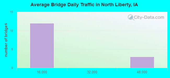
- 171,229Total average daily traffic
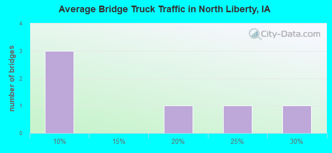
- 31,790Total average daily truck traffic
- National Bridge Inventory (NBI) Registered Bridges for North Liberty
- No street view available for this location
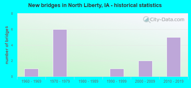
- New bridges - historical statistics
- 11960-1969
- 61970-1979
- 11990-1999
- 22000-2009
- 52010-2019
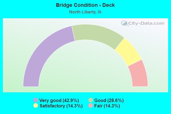
- Bridge Condition - Deck
- 42.9%Very good
- 28.6%Good
- 14.3%Satisfactory
- 14.3%Fair
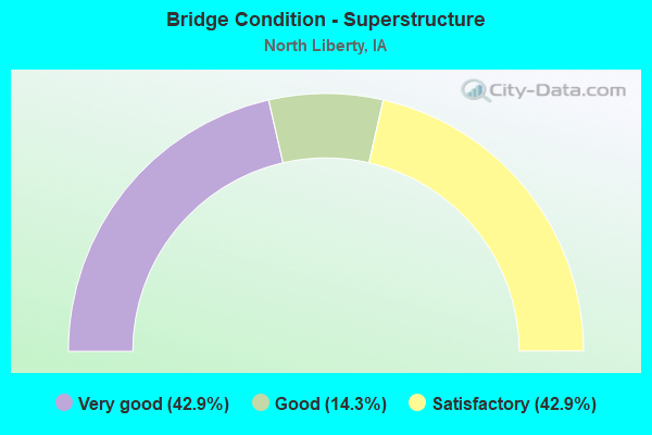
- Bridge Condition - Superstructure
- 42.9%Very good
- 14.3%Good
- 42.9%Satisfactory

- Bridge Condition - Substructure
- 42.9%Very good
- 14.3%Good
- 42.9%Satisfactory
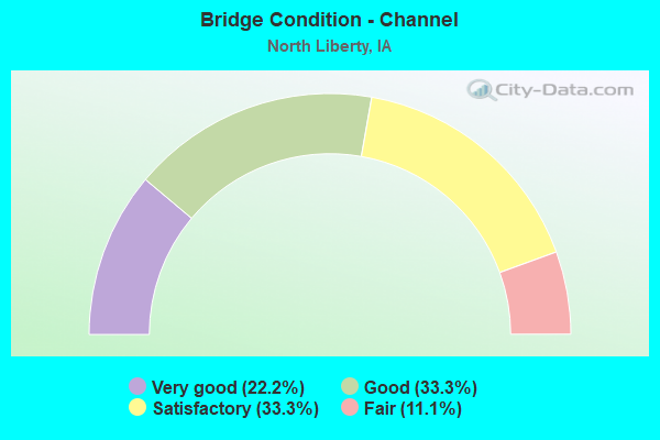
- Bridge Condition - Channel
- 22.2%Very good
- 33.3%Good
- 33.3%Satisfactory
- 11.1%Fair
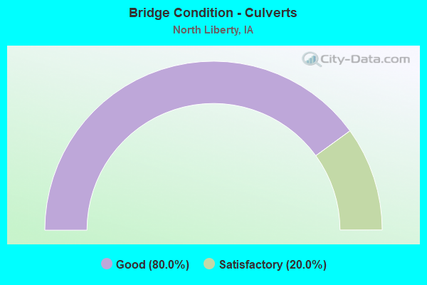
- Bridge Condition - Culverts
- 80.0%Good
- 20.0%Satisfactory
Find on map >> Show street view
Structure Number: 3137, Location: 2.9 MI. S of Jct. US 34 (Lat: 40.944297, Lng: -91.951347), Route carried "on" structure: State highway 1, Year Built: 1967, Status: Open, Structure Length: 8.66m (28.41ft), Average Daily Traffic: 2,550 (year 2020), Truck Traffic: 8%, Average Future Daily Traffic: 2,550 (year 2040), Design Load: HS 20, Features Intersected: BIG CEDAR CREEK
Minimum Vertical Clearance: 30+ m (98+ ft), Kilometerpoint: 32.374, Lanes on structure: 2, Base Highway Network: Yes, Owner: State Highway Agency, Approaching Roadway Width: 14.0m (45.9ft), Skew: 3 degrees, Material/Design: Steel continuous, Design/Construction: Stringer/Multi-beam, Number Of Spans In Main Unit: 3, Length of Maximum Span: 33.2m (108.9ft), Curb-To-Curb Width: 9.6m (31.5ft), Out-to-Out Width: 10.8m (35.4ft)
Condition: Deck: Fair, Superstructure: Satisfactory, Substructure: Satisfactory, Channel: Satisfactory, Operating Rating: 50.8 metric tons, Method Used To Determine Operating Rating: Allowable Stress (AS), Inventory Rating: 28.1 metric tons, Method Used To Determine Inventory Rating: Allowable Stress (AS), Structural Evaluation: Equal to present minimum criteria, Deck Geometry: Meets minimum limits, Waterway Adequacy: Better than present minimum criteria, Approach Roadway Alignment: Equal to present desirable criteria, Designated Inspection Frequency: Every 24 months, Inspection Date: June 2020, Deck Structure Type: Concrete Cast-file-Place, Wearing Surface/Protective System: Wearing Surface: Low Slump Concrete
Find on map >> Show street view
Structure Number: 204902, Location: 000000000 (Lat: 41.726722, Lng: -91.598122), Route carried "on" structure: City street , Year Built: 2002, Status: Open, Structure Length: 0.76m (2.49ft), Average Daily Traffic: 6,500 (year 2014), Average Future Daily Traffic: 6,500 (year 2041), Design Load: HL 93, Features Intersected: MUDDY CREEK, Facility Carried by Structure: FM SO FRONT ST
Minimum Vertical Clearance: 30+ m (98+ ft), Kilometerpoint: 0.423, Lanes on structure: 2, Owner: County Highway Agency, Approaching Roadway Width: 9.8m (32.2ft), Material/Design: Concrete continuous, Design/Construction: Culvert, Number Of Spans In Main Unit: 2, Length of Maximum Span: 3.7m (12.1ft), Curb or Sidewalk Widths: Left: 4.3m (14.1ft), Right: 4.3m (14.1ft), Out-to-Out Width: 14.6m (47.9ft)
Condition: Channel: Satisfactory, Culverts: Satisfactory, Operating Rating: 46.7 metric tons, Method Used To Determine Operating Rating: Load and Resistance Factor Rating (LRFR) rating reported by rating factor(RF) method using HL-93 loadings, Inventory Rating: 36.0 metric tons, Method Used To Determine Inventory Rating: Load and Resistance Factor Rating (LRFR) rating reported by rating factor(RF) method using HL-93 loadings, Structural Evaluation: Equal to present minimum criteria, Waterway Adequacy: Equal to present desirable criteria, Approach Roadway Alignment: Equal to present desirable criteria, Designated Inspection Frequency: Every 24 months, Inspection Date: May 2021
Find on map >> Show street view
Structure Number: 204971, Location: T80N, R07W, 3 (Lat: 41.774969, Lng: -91.652836), Route carried "on" structure: County highway , Year Built: 2018, Status: Open, Structure Length: 2.55m (8.37ft), Average Daily Traffic: 130 (year 2018), Average Future Daily Traffic: 130 (year 2040), Design Load: HS 20, Features Intersected: BR IOWA RIVER, Facility Carried by Structure: SWAN LAKE RD
Minimum Vertical Clearance: 30+ m (98+ ft), Kilometerpoint: 5.226, Lanes on structure: 2, Owner: County Highway Agency, Approaching Roadway Width: 7.9m (25.9ft), Skew: 3 degrees, Material/Design: Concrete continuous, Design/Construction: Slab, Number Of Spans In Main Unit: 3, Length of Maximum Span: 9.4m (30.8ft), Curb-To-Curb Width: 9.3m (30.5ft), Out-to-Out Width: 10.1m (33.1ft)
Condition: Deck: Very good, Superstructure: Very good, Substructure: Very good, Channel: Very good, Operating Rating: 68.1 metric tons, Method Used To Determine Operating Rating: Load Factor (LF), Inventory Rating: 40.8 metric tons, Method Used To Determine Inventory Rating: Load Factor (LF), Structural Evaluation: Equal to present desirable criteria, Deck Geometry: Equal to present minimum criteria, Waterway Adequacy: Equal to present desirable criteria, Approach Roadway Alignment: Equal to present desirable criteria, Designated Inspection Frequency: Every 24 months, Inspection Date: July 2020, Deck Structure Type: Concrete Cast-file-Place, Wearing Surface/Protective System: Wearing Surface: Monolithic Concrete, Deck Protection: Epoxy Coated Reinforcing
Find on map >> Show street view
Structure Number: 204981, Location: 080070503 (Lat: 41.774778, Lng: -91.690942), Route carried "on" structure: County highway , Year Built: 1973, Status: Open, Structure Length: 1.16m (3.81ft), Average Daily Traffic: 100 (year 2018), Average Future Daily Traffic: 100 (year 2041), Design Load: HS 20, Features Intersected: STREAM, Facility Carried by Structure: SWAN LAKE RD NE
Minimum Vertical Clearance: 30+ m (98+ ft), Kilometerpoint: 1.999, Lanes on structure: 2, Owner: County Highway Agency, Approaching Roadway Width: 7.9m (25.9ft), Material/Design: Concrete, Design/Construction: Stringer/Multi-beam, Number Of Spans In Main Unit: 1, Length of Maximum Span: 11.6m (38.1ft), Curb-To-Curb Width: 7.3m (24.0ft), Out-to-Out Width: 7.9m (25.9ft)
Condition: Deck: Satisfactory, Superstructure: Satisfactory, Substructure: Satisfactory, Channel: Good, Operating Rating: 53.1 metric tons, Method Used To Determine Operating Rating: Allowable Stress (AS), Inventory Rating: 35.3 metric tons, Method Used To Determine Inventory Rating: Allowable Stress (AS), Structural Evaluation: Equal to present minimum criteria, Deck Geometry: Equal to present minimum criteria, Waterway Adequacy: Equal to present desirable criteria, Approach Roadway Alignment: Equal to present minimum criteria, Designated Inspection Frequency: Every 48 months, Inspection Date: April 2021, Deck Structure Type: Concrete Cast-file-Place, Wearing Surface/Protective System: Wearing Surface: Monolithic Concrete
Find on map >> Show street view
Structure Number: 205, Location: 080070903 (Lat: 41.752736, Lng: -91.665728), Route carried "on" structure: County highway , Year Built: 1978, Status: Open, Structure Length: 0.70m (2.30ft), Average Daily Traffic: 1,220 (year 2018), Average Future Daily Traffic: 1,220 (year 2041), Design Load: HL 93, Features Intersected: BR BUFFALO CK, Facility Carried by Structure: FM 250TH ST
Minimum Vertical Clearance: 30+ m (98+ ft), Kilometerpoint: 9.957, Lanes on structure: 2, Owner: County Highway Agency, Approaching Roadway Width: 7.3m (24.0ft), Skew: 3 degrees, Material/Design: Concrete continuous, Design/Construction: Culvert, Number Of Spans In Main Unit: 2, Length of Maximum Span: 3.4m (11.2ft)
Condition: Channel: Fair, Culverts: Good, Operating Rating: 46.7 metric tons, Method Used To Determine Operating Rating: Load and Resistance Factor Rating (LRFR) rating reported by rating factor(RF) method using HL-93 loadings, Inventory Rating: 36.0 metric tons, Method Used To Determine Inventory Rating: Load and Resistance Factor Rating (LRFR) rating reported by rating factor(RF) method using HL-93 loadings, Structural Evaluation: Better than present minimum criteria, Waterway Adequacy: Somewhat better than minimum adequacy, Approach Roadway Alignment: Equal to present desirable criteria, Length Of Structure Improvement: 3.50m (11.48ft), Designated Inspection Frequency: Every 24 months, Inspection Date: April 2021, Bridge Improvement Cost: $58,000, Roadway Improvement Cost: $17,000
Find on map >> Show street view
Structure Number: 205005, Location: At jct. SR F28 (Lat: 41.752450, Lng: -91.642675), Route carried "on" structure: County highway , Year Built: 1970, Status: Open, Structure Length: 7.86m (25.79ft), Average Daily Traffic: 11,600 (year 2019), Truck Traffic: 6%, Average Future Daily Traffic: 11,600 (year 2041), Design Load: HS 20, Features Intersected: I-380, Facility Carried by Structure: FM F-28
Minimum Vertical Clearance: 30+ m (98+ ft), Kilometerpoint: 11.874, Lanes on structure: 2, Lanes under structure: 4, Owner: State Highway Agency, Approaching Roadway Width: 12.8m (42.0ft), Material/Design: Prestressed concrete, Design/Construction: Stringer/Multi-beam, Number Of Spans In Main Unit: 4, Length of Maximum Span: 26.2m (86.0ft), Curb-To-Curb Width: 9.7m (31.8ft), Out-to-Out Width: 10.7m (35.1ft)
Condition: Deck: Good, Superstructure: Satisfactory, Substructure: Satisfactory, Operating Rating: 80.4 metric tons, Method Used To Determine Operating Rating: Load Factor (LF), Inventory Rating: 33.1 metric tons, Method Used To Determine Inventory Rating: Load Factor (LF), Structural Evaluation: Equal to present minimum criteria, Deck Geometry: Meets minimum limits, Underclear: High priority of corrective action, Approach Roadway Alignment: Equal to present minimum criteria, Designated Inspection Frequency: Every 24 months, Inspection Date: August 2021, Deck Structure Type: Concrete Cast-file-Place, Wearing Surface/Protective System: Wearing Surface: Monolithic Concrete
Find on map >> Show street view
Structure Number: 205601, Location: 32R6WT80N (Lat: 41.774567, Lng: -91.562025), Route carried "on" structure: County highway , Year Built: 2015, Status: Open, Structure Length: 17.13m (56.20ft), Average Daily Traffic: 3,840 (year 2018), Truck Traffic: 9%, Average Future Daily Traffic: 3,840 (year 2041), Design Load: HL 93, Features Intersected: IOWA RIVER, Facility Carried by Structure: F28 MEHAFFEY BR RD
Minimum Vertical Clearance: 30+ m (98+ ft), Kilometerpoint: 3.376, Lanes on structure: 2, Owner: County Highway Agency, Approaching Roadway Width: 16.8m (55.1ft), Material/Design: Prestressed concrete, Design/Construction: Stringer/Multi-beam, Number Of Spans In Main Unit: 3, Length of Maximum Span: 70.4m (231.0ft), Curb or Sidewalk Widths: Left: 0.0m, Right: 3.7m (12.1ft), Curb-To-Curb Width: 12.2m (40.0ft), Out-to-Out Width: 16.8m (55.1ft)
Condition: Deck: Very good, Superstructure: Very good, Substructure: Very good, Channel: Very good, Operating Rating: 61.6 metric tons, Method Used To Determine Operating Rating: Load and Resistance Factor Rating (LRFR) rating reported by rating factor(RF) method using HL-93 loadings, Inventory Rating: 47.6 metric tons, Method Used To Determine Inventory Rating: Load and Resistance Factor Rating (LRFR) rating reported by rating factor(RF) method using HL-93 loadings, Structural Evaluation: Equal to present desirable criteria, Deck Geometry: Equal to present minimum criteria, Waterway Adequacy: Superior to present desirable criteria, Approach Roadway Alignment: Equal to present desirable criteria, Designated Inspection Frequency: Every 24 months, Inspection Date: April 2021, Deck Structure Type: Concrete Cast-file-Place, Wearing Surface/Protective System: Wearing Surface: Monolithic Concrete, Deck Protection: Epoxy Coated Reinforcing
Find on map >> Show street view
Structure Number: 50516, Location: East of Crandic RR (Lat: 41.737444, Lng: -91.602033), Route carried "on" structure: City street , Year Built: 2012, Status: Open, Structure Length: 1.59m (5.22ft), Average Daily Traffic: 1,650 (year 2014), Average Future Daily Traffic: 1,650 (year 2041), Features Intersected: MUDDY CREEK, Facility Carried by Structure: GOLFVIEW DRIVE
Minimum Vertical Clearance: 30+ m (98+ ft), Kilometerpoint: 0.539, Lanes on structure: 2, Owner: City or Municipal Highway Agency, Approaching Roadway Width: 9.1m (29.9ft), Material/Design: Concrete continuous, Design/Construction: Culvert, Number Of Spans In Main Unit: 4, Length of Maximum Span: 3.7m (12.1ft)
Condition: Channel: Satisfactory, Culverts: Good, Operating Rating: 43.5 metric tons, Method Used To Determine Operating Rating: Load Factor (LF), Inventory Rating: 32.7 metric tons, Method Used To Determine Inventory Rating: Load Factor (LF), Structural Evaluation: Better than present minimum criteria, Waterway Adequacy: Equal to present desirable criteria, Approach Roadway Alignment: Equal to present minimum criteria, Designated Inspection Frequency: Every 24 months, Inspection Date: May 2021
Find on map >> Show street view
Structure Number: 505165, Location: West of Crandic RR (Lat: 41.744894, Lng: -91.604544), Route carried "on" structure: City street , Year Built: 1999, Status: Open, Structure Length: 0.79m (2.59ft), Average Daily Traffic: 5,600 (year 2010), Average Future Daily Traffic: 5,600 (year 2041), Design Load: HL 93, Features Intersected: MUDDY CREEK, Facility Carried by Structure: ZELLER STREET
Minimum Vertical Clearance: 30+ m (98+ ft), Kilometerpoint: 0.254, Lanes on structure: 2, Owner: City or Municipal Highway Agency, Approaching Roadway Width: 9.1m (29.9ft), Material/Design: Concrete continuous, Design/Construction: Culvert, Number Of Spans In Main Unit: 2, Length of Maximum Span: 3.7m (12.1ft), Curb or Sidewalk Widths: Left: 3.2m (10.5ft), Right: 3.2m (10.5ft), Out-to-Out Width: 15.2m (49.9ft)
Condition: Channel: Good, Culverts: Good, Operating Rating: 45.0 metric tons, Method Used To Determine Operating Rating: Load and Resistance Factor Rating (LRFR) rating reported by rating factor(RF) method using HL-93 loadings, Inventory Rating: 34.7 metric tons, Method Used To Determine Inventory Rating: Load and Resistance Factor Rating (LRFR) rating reported by rating factor(RF) method using HL-93 loadings, Structural Evaluation: Better than present minimum criteria, Waterway Adequacy: Equal to present desirable criteria, Approach Roadway Alignment: Equal to present desirable criteria, Designated Inspection Frequency: Every 24 months, Inspection Date: May 2021
Find on map >> Show street view
Structure Number: 50517, Location: East of Crandic RR (Lat: 41.734531, Lng: -91.601178), Route carried "on" structure: City street , Year Built: 2003, Status: Open, Structure Length: 2.00m (6.56ft), Average Daily Traffic: 289 (year 2005), Average Future Daily Traffic: 289 (year 2041), Design Load: HS 20, Features Intersected: MUDDY CREEK, Facility Carried by Structure: RACHAEL STREET
Minimum Vertical Clearance: 30+ m (98+ ft), Kilometerpoint: 0.391, Lanes on structure: 2, Owner: City or Municipal Highway Agency, Approaching Roadway Width: 9.1m (29.9ft), Material/Design: Concrete continuous, Design/Construction: Culvert, Number Of Spans In Main Unit: 3, Length of Maximum Span: 6.1m (20.0ft)
Condition: Channel: Good, Culverts: Good, Operating Rating: 43.5 metric tons, Method Used To Determine Operating Rating: Load Factor (LF), Inventory Rating: 32.7 metric tons, Method Used To Determine Inventory Rating: Load Factor (LF), Structural Evaluation: Better than present minimum criteria, Waterway Adequacy: Equal to present desirable criteria, Approach Roadway Alignment: Somewhat better than minimum adequacy, Designated Inspection Frequency: Every 24 months, Inspection Date: May 2021
Find on map >> Show street view
Structure Number: 600431, Location: 2 MI. N. OF I-80 (Lat: 41.723572, Lng: -91.642636), Route carried "on" structure: City street , Year Built: 2017, Status: Open, Structure Length: 8.69m (28.51ft), Average Daily Traffic: 2,120 (year 2019), Average Future Daily Traffic: 2,120 (year 2040), Design Load: HL 93, Features Intersected: I 380, Facility Carried by Structure: FOREVERGREEN RD
Minimum Vertical Clearance: 30+ m (98+ ft), Kilometerpoint: 0.359, Lanes on structure: 4, Lanes under structure: 8, Owner: State Highway Agency, Approaching Roadway Width: 21.3m (69.9ft), Material/Design: Prestressed concrete, Design/Construction: Stringer/Multi-beam, Number Of Spans In Main Unit: 2, Length of Maximum Span: 43.0m (141.1ft), Curb or Sidewalk Widths: Left: 1.7m (5.6ft), Right: 3.2m (10.5ft), Curb-To-Curb Width: 21.3m (69.9ft), Out-to-Out Width: 27.4m (89.9ft)
Condition: Deck: Very good, Superstructure: Very good, Substructure: Very good, Operating Rating: 42.1 metric tons, Method Used To Determine Operating Rating: Assigned ratings based on Load and Resistance Factor Design (LRFD) reported by rating factor (RF) using HL93 loadings, Inventory Rating: 32.4 metric tons, Method Used To Determine Inventory Rating: Assigned ratings based on Load and Resistance Factor Design (LRFD) reported by rating factor (RF) using HL93 loadings, Structural Evaluation: Equal to present desirable criteria, Deck Geometry: Superior to present desirable criteria, Underclear: Better than present minimum criteria, Approach Roadway Alignment: Equal to present desirable criteria, Designated Inspection Frequency: Every 24 months, Inspection Date: May 2020, Deck Structure Type: Concrete Cast-file-Place, Wearing Surface/Protective System: Wearing Surface: Monolithic Concrete, Deck Protection: Epoxy Coated Reinforcing
Find on map >> Show street view
Structure Number: 60045, Location: 5.6 MI. N OF JCT. I-80 (Lat: 41.775003, Lng: -91.647047), Route carried "on" structure: County highway , Year Built: 1971, Status: Open, Structure Length: 7.62m (25.00ft), Average Daily Traffic: 130 (year 2018), Average Future Daily Traffic: 130 (year 2040), Design Load: H 20, Features Intersected: I-380, Facility Carried by Structure: LOCAL RD
Minimum Vertical Clearance: 30+ m (98+ ft), Kilometerpoint: 5.707, Lanes on structure: 2, Lanes under structure: 4, Owner: State Highway Agency, Approaching Roadway Width: 12.2m (40.0ft), Material/Design: Prestressed concrete, Design/Construction: Stringer/Multi-beam, Number Of Spans In Main Unit: 4, Length of Maximum Span: 26.5m (86.9ft), Curb or Sidewalk Widths: Left: 0.3m (1.0ft), Right: 0.3m (1.0ft), Curb-To-Curb Width: 9.2m (30.2ft), Out-to-Out Width: 10.2m (33.5ft)
Condition: Deck: Good, Superstructure: Good, Substructure: Good, Operating Rating: 71.5 metric tons, Method Used To Determine Operating Rating: Load Factor (LF), Inventory Rating: 28.0 metric tons, Method Used To Determine Inventory Rating: Load Factor (LF), Structural Evaluation: Better than present minimum criteria, Deck Geometry: Equal to present minimum criteria, Underclear: Equal to present minimum criteria, Approach Roadway Alignment: Better than present minimum criteria, Designated Inspection Frequency: Every 24 months, Inspection Date: June 2020, Deck Structure Type: Concrete Cast-file-Place, Wearing Surface/Protective System: Wearing Surface: Monolithic Concrete
Find on map >> Show street view
Structure Number: 205005, Location: At jct. SR F28 (Lat: 41.752450, Lng: -91.642675), Route carried "under" structure: Interstate 380, Year Built: 1970, Structure Length: 0. m, Average Daily Traffic: 41,000 (year 2020), Truck Traffic: 25%, Features Intersected: I-380, Facility Carried by Structure: FM F-28
Minimum Vertical Clearance: 30+ m (98+ ft), Kilometerpoint: 6.518, Lanes on structure: 2, Lanes under structure: 4, Material/Design: Prestressed concrete, Design/Construction: Stringer/Multi-beam, Length of Maximum Span: 26.2m (86.0ft)
Find on map >> Show street view
Structure Number: 600431, Location: 2 MI. N. OF I-80 (Lat: 41.723572, Lng: -91.642636), Route carried "under" structure: Interstate 380, Year Built: 2017, Structure Length: 0. m, Average Daily Traffic: 46,800 (year 2020), Truck Traffic: 24%, Features Intersected: I 380, Facility Carried by Structure: FOREVERGREEN RD
Minimum Vertical Clearance: 30+ m (98+ ft), Kilometerpoint: 3.299, Lanes on structure: 4, Lanes under structure: 8, Material/Design: Prestressed concrete, Design/Construction: Stringer/Multi-beam, Length of Maximum Span: 43.0m (141.1ft)
Find on map >> Show street view
Structure Number: 60045, Location: 5.6 MI. N OF JCT. I-80 (Lat: 41.775003, Lng: -91.647047), Route carried "under" structure: Interstate 380, Year Built: 1971, Structure Length: 0. m, Average Daily Traffic: 47,700 (year 2020), Truck Traffic: 19%, Features Intersected: I-380, Facility Carried by Structure: LOCAL RD
Minimum Vertical Clearance: 30+ m (98+ ft), Kilometerpoint: 9.073, Lanes on structure: 2, Lanes under structure: 4, Material/Design: Prestressed concrete, Design/Construction: Stringer/Multi-beam, Length of Maximum Span: 26.5m (86.9ft)