Bridge Statistics for North Babylon, New York (NY)
Condition, Traffic, Stress, Structural Evaluation, Project Costs
- National Bridge Inventory (NBI) Statistics
- 14Number of bridges
- 115ft / 34.5mTotal length
- $44,146,000Total costs
- 685,009Total average daily traffic
- 11,126Total average daily truck traffic
- National Bridge Inventory (NBI) Registered Bridges for North Babylon
- No street view available for this location
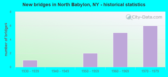
- New bridges - historical statistics
- 11930-1939
- 21950-1959
- 51960-1969
- 61970-1979
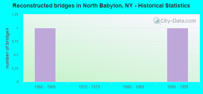
- Reconstructed bridges - Historical Statistics
- 11960-1969
- 01970-1979
- 01980-1989
- 11990-1999
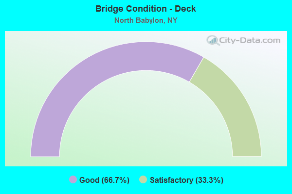
- Bridge Condition - Deck
- 66.7%Good
- 33.3%Satisfactory
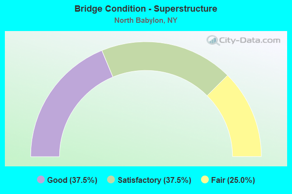
- Bridge Condition - Superstructure
- 37.5%Good
- 37.5%Satisfactory
- 25.0%Fair
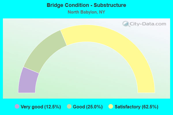
- Bridge Condition - Substructure
- 12.5%Very good
- 25.0%Good
- 62.5%Satisfactory
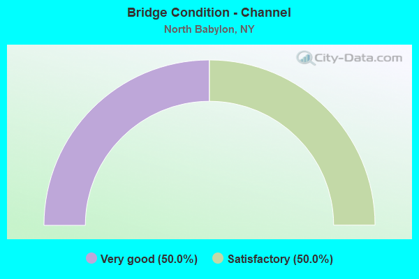
- Bridge Condition - Channel
- 50.0%Very good
- 50.0%Satisfactory
Find on map >> Show street view
Structure Number: 1018329, Location: 2.0 MI E JCT RTS 27+109 (Lat: 40.714475, Lng: -73.331314), Route carried "on" structure: State highway 27, Year Built: 1932, Year Reconstructed: 1966, Status: Open, Structure Length: 0.91m (2.99ft), Average Daily Traffic: 73,172 (year 2018), Truck Traffic: 7%, Average Future Daily Traffic: 87,038 (year 2040), Design Load: HS 20, Features Intersected: CARLLS RIVER, PARK PED.&
Minimum Vertical Clearance: 30+ m (98+ ft), Kilometerpoint: 8.994, Lanes on structure: 12, Base Highway Network: Yes, Owner: State Highway Agency, Approaching Roadway Width: 47.5m (155.8ft), Skew: 20 degrees, Material/Design: Concrete, Design/Construction: Arch - Deck, Number Of Spans In Main Unit: 1, Length of Maximum Span: 8.8m (28.9ft), Curb or Sidewalk Widths: Left: 2.4m (7.9ft), Right: 2.4m (7.9ft), Curb-To-Curb Width: 47.5m (155.8ft), Out-to-Out Width: 69.5m (228.0ft)
Condition: Superstructure: Fair, Substructure: Satisfactory, Channel: Satisfactory, Operating Rating: 76.3 metric tons, Method Used To Determine Operating Rating: Field evaluation and documented engineering judgment, Inventory Rating: 19.6 metric tons, Method Used To Determine Inventory Rating: Field evaluation and documented engineering judgment, Structural Evaluation: Meets minimum limits, Deck Geometry: Meets minimum limits, Waterway Adequacy: Meets minimum limits, Approach Roadway Alignment: Equal to present desirable criteria, Length Of Structure Improvement: 0.91m (2.99ft), Designated Inspection Frequency: Every 24 months, Inspection Date: November 2021, Bridge Improvement Cost: $3,054,000, Roadway Improvement Cost: $1,788,000, Total Project Cost: $4,842,000 ( Estimate for 2021), Wearing Surface/Protective System: Wearing Surface: Bituminous, Membrane: Preformed Fabric
Find on map >> Show street view
Structure Number: 1018341, Location: JCT SH 231 & SH 27 (Lat: 40.717797, Lng: -73.314350), Route carried "on" structure: State highway 231, Year Built: 1971, Year Reconstructed: 1996, Status: Open, Structure Length: 8.53m (27.99ft), Average Daily Traffic: 13,075 (year 2020), Truck Traffic: 6%, Average Future Daily Traffic: 15,552 (year 2040), Design Load: HS 25 or greater, Features Intersected: 27 27 07051065, 27 27
Minimum Vertical Clearance: 30+ m (98+ ft), Kilometerpoint: 2.365, Lanes on structure: 3, Lanes under structure: 12, Base Highway Network: Yes, Owner: State Highway Agency, Approaching Roadway Width: 12.2m (40.0ft), Skew: 1 degrees, Material/Design: Steel, Design/Construction: Stringer/Multi-beam, Number Of Spans In Main Unit: 4, Length of Maximum Span: 24.6m (80.7ft), Curb-To-Curb Width: 12.2m (40.0ft), Out-to-Out Width: 13.2m (43.3ft)
Condition: Deck: Good, Superstructure: Satisfactory, Substructure: Satisfactory, Operating Rating: 83.5 metric tons, Method Used To Determine Operating Rating: Load Factor (LF), Inventory Rating: 46.3 metric tons, Method Used To Determine Inventory Rating: Load Factor (LF), Structural Evaluation: Equal to present minimum criteria, Deck Geometry: Meets minimum limits, Underclear: High priority of corrective action, Approach Roadway Alignment: Equal to present desirable criteria, Length Of Structure Improvement: 8.53m (27.99ft), Designated Inspection Frequency: Every 24 months, Inspection Date: July 2020, Bridge Improvement Cost: $4,167,000, Roadway Improvement Cost: $2,440,000, Total Project Cost: $6,607,000 ( Estimate for 2021), Deck Structure Type: Concrete Cast-file-Place, Wearing Surface/Protective System: Wearing Surface: Integral Concrete, Deck Protection: Epoxy Coated Reinforcing
Find on map >> Show street view
Structure Number: 1018342, Location: JCT SH 231 & SH 27 (Lat: 40.717981, Lng: -73.314106), Route carried "on" structure: State highway 231, Year Built: 1971, Status: Open, Structure Length: 8.66m (28.41ft), Average Daily Traffic: 13,075 (year 2020), Truck Traffic: 6%, Average Future Daily Traffic: 15,552 (year 2040), Design Load: HS 25 or greater, Features Intersected: 27 27 0705 1065 W/B Serv
Minimum Vertical Clearance: 30+ m (98+ ft), Kilometerpoint: 2.365, Lanes on structure: 3, Lanes under structure: 12, Base Highway Network: Yes, Owner: State Highway Agency, Approaching Roadway Width: 12.2m (40.0ft), Skew: 1 degrees, Material/Design: Steel, Design/Construction: Stringer/Multi-beam, Number Of Spans In Main Unit: 4, Length of Maximum Span: 24.6m (80.7ft), Curb-To-Curb Width: 12.2m (40.0ft), Out-to-Out Width: 13.2m (43.3ft)
Condition: Deck: Satisfactory, Superstructure: Satisfactory, Substructure: Satisfactory, Operating Rating: 83.5 metric tons, Method Used To Determine Operating Rating: Load Factor (LF), Inventory Rating: 46.3 metric tons, Method Used To Determine Inventory Rating: Load Factor (LF), Structural Evaluation: Equal to present minimum criteria, Deck Geometry: Meets minimum limits, Underclear: High priority of corrective action, Approach Roadway Alignment: Equal to present desirable criteria, Length Of Structure Improvement: 8.65m (28.38ft), Designated Inspection Frequency: Every 24 months, Inspection Date: July 2020, Bridge Improvement Cost: $4,250,000, Roadway Improvement Cost: $2,489,000, Total Project Cost: $6,739,000 ( Estimate for 2021), Deck Structure Type: Concrete Cast-file-Place, Wearing Surface/Protective System: Wearing Surface: Integral Concrete, Deck Protection: Epoxy Coated Reinforcing
Find on map >> Show street view
Structure Number: 104218, Location: JCT SH 231 & SSP (Lat: 40.732108, Lng: -73.320669), Route carried "on" structure: State highway 231, Year Built: 1950, Status: Open, Structure Length: 3.29m (10.79ft), Average Daily Traffic: 40,732 (year 2020), Truck Traffic: 6%, Average Future Daily Traffic: 48,450 (year 2040), Features Intersected: 908M908M07021063 WB, RTE
Minimum Vertical Clearance: 30+ m (98+ ft), Kilometerpoint: 4.135, Lanes on structure: 4, Lanes under structure: 6, Base Highway Network: Yes, Owner: State Highway Agency, Approaching Roadway Width: 14.9m (48.9ft), Skew: 1 degrees, Material/Design: Concrete continuous, Design/Construction: Frame, Number Of Spans In Main Unit: 2, Length of Maximum Span: 15.5m (50.9ft), Curb or Sidewalk Widths: Left: 0.0m, Right: 3.5m (11.5ft), Curb-To-Curb Width: 14.9m (48.9ft), Out-to-Out Width: 19.8m (65.0ft)
Condition: Deck: Satisfactory, Superstructure: Satisfactory, Substructure: Satisfactory, Operating Rating: 49.9 metric tons, Method Used To Determine Operating Rating: Load Factor (LF), Inventory Rating: 29.9 metric tons, Method Used To Determine Inventory Rating: Load Factor (LF), Structural Evaluation: Equal to present minimum criteria, Deck Geometry: High priority of replacement, Underclear: High priority of corrective action, Approach Roadway Alignment: Better than present minimum criteria, Length Of Structure Improvement: 3.29m (10.79ft), Designated Inspection Frequency: Every 24 months, Inspection Date: March 2020, Bridge Improvement Cost: $3,378,000, Roadway Improvement Cost: $1,978,000, Total Project Cost: $5,357,000 ( Estimate for 2021), Wearing Surface/Protective System: Wearing Surface: Bituminous, Membrane: Preformed Fabric
Find on map >> Show street view
Structure Number: 105625, Location: JCT SH 231 & SSP (Lat: 40.731953, Lng: -73.320858), Route carried "on" structure: State highway 231, Year Built: 1968, Status: Open, Structure Length: 4.11m (13.48ft), Average Daily Traffic: 26,150 (year 2020), Truck Traffic: 6%, Average Future Daily Traffic: 31,105 (year 2040), Design Load: HS 20, Features Intersected: 908M908M07021063 WB, RTE
Minimum Vertical Clearance: 30+ m (98+ ft), Kilometerpoint: 4.135, Lanes on structure: 4, Lanes under structure: 6, Base Highway Network: Yes, Owner: State Highway Agency, Approaching Roadway Width: 14.9m (48.9ft), Skew: 1 degrees, Material/Design: Concrete continuous, Design/Construction: Frame, Number Of Spans In Main Unit: 2, Length of Maximum Span: 19.5m (64.0ft), Curb or Sidewalk Widths: Left: 2.8m (9.2ft), Right: 0.0m, Curb-To-Curb Width: 14.9m (48.9ft), Out-to-Out Width: 18.6m (61.0ft)
Condition: Deck: Good, Superstructure: Good, Substructure: Good, Operating Rating: 79.8 metric tons, Method Used To Determine Operating Rating: Load Factor (LF), Inventory Rating: 42.6 metric tons, Method Used To Determine Inventory Rating: Load Factor (LF), Structural Evaluation: Better than present minimum criteria, Deck Geometry: High priority of replacement, Underclear: High priority of corrective action, Approach Roadway Alignment: Better than present minimum criteria, Length Of Structure Improvement: 4.11m (13.48ft), Designated Inspection Frequency: Every 24 months, Inspection Date: March 2020, Bridge Improvement Cost: $3,696,000, Roadway Improvement Cost: $2,164,000, Total Project Cost: $5,860,000 ( Estimate for 2021), Wearing Surface/Protective System: Wearing Surface: Bituminous, Membrane: Preformed Fabric
Find on map >> Show street view
Structure Number: 105981, Location: BETWEEN EXITS 37 & 38 - S (Lat: 40.732097, Lng: -73.341514), Route carried "on" structure: Ramp Other road , Year Built: 1960, Status: Open, Structure Length: 1.10m (3.61ft), Average Daily Traffic: 3,708 (year 2018), Truck Traffic: 4%, Average Future Daily Traffic: 5,191 (year 2038), Design Load: HS 20, Features Intersected: CARLLS RIVER, PEDESTRIAN, Facility Carried by Structure: SYLVAN RD
Minimum Vertical Clearance: 30+ m (98+ ft), Kilometerpoint: 0.209, Lanes on structure: 2, Owner: State Highway Agency, Approaching Roadway Width: 7.3m (24.0ft), Material/Design: Concrete, Design/Construction: Arch - Deck, Number Of Spans In Main Unit: 1, Length of Maximum Span: 9.7m (31.8ft), Curb or Sidewalk Widths: Left: 1.1m (3.6ft), Right: 1.1m (3.6ft), Curb-To-Curb Width: 7.3m (24.0ft), Out-to-Out Width: 10.4m (34.1ft)
Condition: Superstructure: Fair, Substructure: Satisfactory, Channel: Very good, Operating Rating: 77.1 metric tons, Method Used To Determine Operating Rating: Load Factor (LF), Inventory Rating: 53.5 metric tons, Method Used To Determine Inventory Rating: Load Factor (LF), Structural Evaluation: Somewhat better than minimum adequacy, Deck Geometry: High priority of replacement, Waterway Adequacy: Somewhat better than minimum adequacy, Approach Roadway Alignment: Equal to present desirable criteria, Length Of Structure Improvement: 1.09m (3.58ft), Designated Inspection Frequency: Every 24 months, Inspection Date: August 2020, Bridge Improvement Cost: $520,000, Roadway Improvement Cost: $305,000, Total Project Cost: $825,000 ( Estimate for 2021), Wearing Surface/Protective System: Wearing Surface: Monolithic Concrete
Find on map >> Show street view
Structure Number: 1059829, Location: .9 MI W JCT RTS 231+SSP (Lat: 40.733147, Lng: -73.338389), Route carried "on" structure: State highway 908M, Year Built: 1962, Status: Open, Structure Length: 0.94m (3.08ft), Average Daily Traffic: 130,667 (year 2020), Average Future Daily Traffic: 155,428 (year 2040), Features Intersected: BELMONT PK ENTR
Minimum Vertical Clearance: 30+ m (98+ ft), Kilometerpoint: 8.624, Lanes on structure: 7, Lanes under structure: 2, Base Highway Network: Yes, Owner: State Highway Agency, Approaching Roadway Width: 35.7m (117.1ft), Skew: 20 degrees, Material/Design: Concrete, Design/Construction: Frame, Number Of Spans In Main Unit: 1, Length of Maximum Span: 9.1m (29.9ft), Curb-To-Curb Width: 35.7m (117.1ft), Out-to-Out Width: 37.4m (122.7ft)
Condition: Deck: Good, Superstructure: Good, Substructure: Good, Operating Rating: 79.1 metric tons, Method Used To Determine Operating Rating: Field evaluation and documented engineering judgment, Inventory Rating: 32.7 metric tons, Method Used To Determine Inventory Rating: Field evaluation and documented engineering judgment, Structural Evaluation: Better than present minimum criteria, Deck Geometry: Superior to present desirable criteria, Underclear: High priority of corrective action, Approach Roadway Alignment: Better than present minimum criteria, Length Of Structure Improvement: 0.94m (3.08ft), Designated Inspection Frequency: Every 24 months, Inspection Date: March 2020, Bridge Improvement Cost: $2,693,000, Roadway Improvement Cost: $1,577,000, Total Project Cost: $4,271,000 ( Estimate for 2021), Wearing Surface/Protective System: Wearing Surface: Bituminous, Membrane: Preformed Fabric
Find on map >> Show street view
Structure Number: 106401, Location: 2.3 MI E JCT SH 27 & SH10 (Lat: 40.716289, Lng: -73.322111), Route carried "on" structure: County highway , Year Built: 1972, Status: Open, Structure Length: 7.01m (23.00ft), Average Daily Traffic: 13,806 (year 2019), Truck Traffic: 2%, Average Future Daily Traffic: 16,771 (year 2040), Design Load: HS 20, Features Intersected: 27 27 07051061 Service,, Facility Carried by Structure: DEER PARK AVE
Minimum Vertical Clearance: 30+ m (98+ ft), Kilometerpoint: 0.611, Lanes on structure: 3, Lanes under structure: 10, Owner: State Highway Agency, Approaching Roadway Width: 15.8m (51.8ft), Material/Design: Steel, Design/Construction: Stringer/Multi-beam, Number Of Spans In Main Unit: 4, Length of Maximum Span: 17.3m (56.8ft), Curb or Sidewalk Widths: Left: 1.5m (4.9ft), Right: 1.5m (4.9ft), Curb-To-Curb Width: 15.8m (51.8ft), Out-to-Out Width: 19.5m (64.0ft)
Condition: Deck: Good, Superstructure: Good, Substructure: Very good, Operating Rating: 59.6 metric tons, Method Used To Determine Operating Rating: Load and Resistance Factor Rating (LRFR) rating reported by rating factor(RF) method using HL-93 loadings, Inventory Rating: 45.7 metric tons, Method Used To Determine Inventory Rating: Load and Resistance Factor Rating (LRFR) rating reported by rating factor(RF) method using HL-93 loadings, Structural Evaluation: Better than present minimum criteria, Deck Geometry: Better than present minimum criteria, Underclear: High priority of corrective action, Approach Roadway Alignment: Better than present minimum criteria, Length Of Structure Improvement: 7.01m (23.00ft), Designated Inspection Frequency: Every 24 months, Inspection Date: August 2020, Bridge Improvement Cost: $6,083,000, Roadway Improvement Cost: $3,562,000, Total Project Cost: $9,645,000 ( Estimate for 2021), Deck Structure Type: Concrete Cast-file-Place, Wearing Surface/Protective System: Wearing Surface: Monolithic Concrete
Find on map >> Show street view
Structure Number: 1018341, Location: JCT SH 231 & SH 27 (Lat: 40.717797, Lng: -73.314350), Route carried "under" structure: State highway 27, Year Built: 1971, Structure Length: 0. m, Average Daily Traffic: 40,200 (year 1973), Features Intersected: 27 27 07051065, 27 27, Facility Carried by Structure: RTE 231
Minimum Vertical Clearance: 4.42m (14.50ft), Kilometerpoint: 10.491, Lanes on structure: 3, Lanes under structure: 3, Material/Design: Steel, Design/Construction: Stringer/Multi-beam, Length of Maximum Span: 24.6m (80.7ft)
Find on map >> Show street view
Structure Number: 1018342, Location: JCT SH 231 & SH 27 (Lat: 40.717981, Lng: -73.314106), Route carried "under" structure: State highway 27, Year Built: 1971, Structure Length: 0. m, Average Daily Traffic: 40,200 (year 1973), Features Intersected: 27 27 0705 1065 W/B Serv, Facility Carried by Structure: RTE 231
Minimum Vertical Clearance: 4.42m (14.50ft), Kilometerpoint: 9.799, Lanes on structure: 3, Lanes under structure: 3, Material/Design: Steel, Design/Construction: Stringer/Multi-beam, Length of Maximum Span: 24.6m (80.7ft)
Find on map >> Show street view
Structure Number: 104218, Location: JCT SH 231 & SSP (Lat: 40.732108, Lng: -73.320669), Route carried "under" structure: State highway 908M, Year Built: 1950, Structure Length: 0. m, Average Daily Traffic: 119,012 (year 2002), Features Intersected: 908M908M07021063 WB, RTE, Facility Carried by Structure: RTE 231
Minimum Vertical Clearance: 4.06m (13.32ft), Kilometerpoint: 10.459, Lanes on structure: 4, Lanes under structure: 3, Material/Design: Concrete continuous, Design/Construction: Frame, Length of Maximum Span: 15.5m (50.9ft)
Find on map >> Show street view
Structure Number: 105625, Location: JCT SH 231 & SSP (Lat: 40.731953, Lng: -73.320858), Route carried "under" structure: State highway 908M, Year Built: 1968, Structure Length: 0. m, Average Daily Traffic: 119,012 (year 2002), Features Intersected: 908M908M07021063 WB, RTE, Facility Carried by Structure: RTE 231
Minimum Vertical Clearance: 4.17m (13.68ft), Kilometerpoint: 10.459, Lanes on structure: 4, Lanes under structure: 3, Material/Design: Concrete continuous, Design/Construction: Frame, Length of Maximum Span: 19.5m (64.0ft)
Find on map >> Show street view
Structure Number: 1059829, Location: .9 MI W JCT RTS 231+SSP (Lat: 40.733147, Lng: -73.338389), Route carried "under" structure: Other road , Year Built: 1962, Structure Length: 0. m, Average Daily Traffic: 1,200 (year 2021), Features Intersected: BELMONT PK ENTR, Facility Carried by Structure: RTE 908M
Minimum Vertical Clearance: 3.86m (12.66ft), Kilometerpoint: 0.000, Lanes on structure: 7, Lanes under structure: 2, Material/Design: Concrete, Design/Construction: Frame, Length of Maximum Span: 9.1m (29.9ft)
Find on map >> Show street view
Structure Number: 106401, Location: 2.3 MI E JCT SH 27 & SH10 (Lat: 40.716289, Lng: -73.322111), Route carried "under" structure: State highway 27, Year Built: 1972, Structure Length: 0. m, Average Daily Traffic: 51,000 (year 1979), Features Intersected: 27 27 07051061 Service,, Facility Carried by Structure: DEER PARK AVE
Minimum Vertical Clearance: 4.57m (14.99ft), Kilometerpoint: 9.799, Lanes on structure: 3, Lanes under structure: 3, Material/Design: Steel, Design/Construction: Stringer/Multi-beam, Length of Maximum Span: 17.3m (56.8ft)