Bridge Statistics for Nevada, Iowa (IA)
Condition, Traffic, Stress, Structural Evaluation, Project Costs
- National Bridge Inventory (NBI) Statistics
- 35Number of bridges
- 374ft / 114mTotal length
- 92,920Total average daily traffic
- 9,370Total average daily truck traffic
- National Bridge Inventory (NBI) Registered Bridges for Nevada
- No street view available for this location
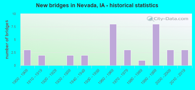
- New bridges - historical statistics
- 31900-1909
- 21910-1919
- 21930-1939
- 21940-1949
- 81960-1969
- 31970-1979
- 11980-1989
- 81990-1999
- 32000-2009
- 32010-2019

- Reconstructed bridges - Historical Statistics
- 41960-1969
- 11970-1979
- 11980-1989
- 01990-1999
- 32000-2009
- 12010-2019


- Bridge Condition - Deck
- 11.1%Very good
- 25.9%Good
- 40.7%Satisfactory
- 18.5%Fair
- 3.7%Poor

- Bridge Condition - Superstructure
- 18.5%Very good
- 25.9%Good
- 37.0%Satisfactory
- 11.1%Fair
- 3.7%Poor
- 3.7%Serious

- Bridge Condition - Substructure
- 22.2%Very good
- 29.6%Good
- 22.2%Satisfactory
- 11.1%Fair
- 14.8%Poor

- Bridge Condition - Channel
- 11.1%Very good
- 55.6%Good
- 29.6%Satisfactory
- 3.7%Fair

- Bridge Condition - Culverts
- 33.3%Very good
- 33.3%Good
- 16.7%Satisfactory
- 16.7%Fair
Find on map >> Show street view
Structure Number: 853, Location: 000000000 (Lat: 42.010983, Lng: -93.449506), Route carried "on" structure: City street , Year Built: 1936, Status: Open, Structure Length: 1.34m (4.40ft), Average Daily Traffic: 560 (year 2019), Average Future Daily Traffic: 560 (year 2041), Design Load: HS 20, Features Intersected: W BR INDIAN CREEK, Facility Carried by Structure: 8TH ST
Minimum Vertical Clearance: 30+ m (98+ ft), Kilometerpoint: 0.011, Lanes on structure: 2, Owner: City or Municipal Highway Agency, Approaching Roadway Width: 7.9m (25.9ft), Material/Design: Steel, Design/Construction: Stringer/Multi-beam, Number Of Spans In Main Unit: 1, Length of Maximum Span: 12.5m (41.0ft), Curb-To-Curb Width: 7.7m (25.3ft), Out-to-Out Width: 8.6m (28.2ft)
Condition: Deck: Poor, Superstructure: Serious, Substructure: Satisfactory, Channel: Satisfactory, Operating Rating: 15.1 metric tons, Method Used To Determine Operating Rating: Load Factor (LF), Inventory Rating: 9.0 metric tons, Method Used To Determine Inventory Rating: Load Factor (LF), Structural Evaluation: High priority of corrective action, Deck Geometry: Meets minimum limits, Waterway Adequacy: Equal to present minimum criteria, Approach Roadway Alignment: Meets minimum limits, Bridge Posting: Required (Relationship of Operating Rating to Maximum Legal Load: > 39.9% below), Designated Inspection Frequency: Every 24 months, Inspection Date: June 2021, Deck Structure Type: Concrete Cast-file-Place, Wearing Surface/Protective System: Wearing Surface: Bituminous
Find on map >> Show street view
Structure Number: 8565, Location: 000000000 (Lat: 42.015597, Lng: -93.456664), Route carried "on" structure: City street , Year Built: 1967, Status: Open, Structure Length: 3.11m (10.20ft), Average Daily Traffic: 580 (year 2019), Average Future Daily Traffic: 580 (year 2041), Design Load: H 20, Features Intersected: W BR INDIAN CREEK, Facility Carried by Structure: E AVE
Minimum Vertical Clearance: 30+ m (98+ ft), Kilometerpoint: 0.515, Lanes on structure: 2, Owner: City or Municipal Highway Agency, Approaching Roadway Width: 9.1m (29.9ft), Material/Design: Concrete continuous, Design/Construction: Slab, Number Of Spans In Main Unit: 3, Length of Maximum Span: 11.9m (39.0ft), Curb-To-Curb Width: 8.5m (27.9ft), Out-to-Out Width: 9.1m (29.9ft)
Condition: Deck: Satisfactory, Superstructure: Satisfactory, Substructure: Satisfactory, Channel: Satisfactory, Operating Rating: 54.9 metric tons, Method Used To Determine Operating Rating: Field evaluation and documented engineering judgment, Inventory Rating: 31.5 metric tons, Method Used To Determine Inventory Rating: Field evaluation and documented engineering judgment, Structural Evaluation: Equal to present minimum criteria, Deck Geometry: Somewhat better than minimum adequacy, Waterway Adequacy: Better than present minimum criteria, Approach Roadway Alignment: Better than present minimum criteria, Designated Inspection Frequency: Every 24 months, Inspection Date: June 2021, Deck Structure Type: Concrete Cast-file-Place, Wearing Surface/Protective System: Wearing Surface: Monolithic Concrete
Find on map >> Show street view
Structure Number: 2228, Location: At the Jct. US 6 & US 169 (Lat: 41.540075, Lng: -94.013147), Route carried "on" structure: Interstate 80, Year Built: 1966, Status: Open, Structure Length: 6.55m (21.49ft), Average Daily Traffic: 11,900 (year 2020), Truck Traffic: 32%, Average Future Daily Traffic: 11,900 (year 2040), Design Load: HS 20, Features Intersected: US 6/169
Minimum Vertical Clearance: 30+ m (98+ ft), Kilometerpoint: 176.799, Lanes on structure: 2, Lanes under structure: 2, Base Highway Network: Yes, Owner: State Highway Agency, Approaching Roadway Width: 12.2m (40.0ft), Material/Design: Prestressed concrete, Design/Construction: Stringer/Multi-beam, Number Of Spans In Main Unit: 4, Length of Maximum Span: 21.0m (68.9ft), Curb or Sidewalk Widths: Left: 0.2m (0.7ft), Right: 0.2m (0.7ft), Curb-To-Curb Width: 11.9m (39.0ft), Out-to-Out Width: 12.9m (42.3ft)
Condition: Deck: Satisfactory, Superstructure: Fair, Substructure: Good, Operating Rating: 87.0 metric tons, Method Used To Determine Operating Rating: Load Factor (LF), Inventory Rating: 37.7 metric tons, Method Used To Determine Inventory Rating: Load Factor (LF), Structural Evaluation: Somewhat better than minimum adequacy, Deck Geometry: Equal to present minimum criteria, Underclear: Equal to present minimum criteria, Approach Roadway Alignment: Equal to present desirable criteria, Designated Inspection Frequency: Every 24 months, Inspection Date: June 2020, Deck Structure Type: Concrete Cast-file-Place, Wearing Surface/Protective System: Wearing Surface: Low Slump Concrete
Find on map >> Show street view
Structure Number: 4878, Location: 2.8 MILES E OF JCT I-35 (Lat: 42.008783, Lng: -93.516786), Route carried "on" structure: US 30, Year Built: 1964, Year Reconstructed: 2013, Status: Open, Structure Length: 2.50m (8.20ft), Average Daily Traffic: 7,300 (year 2020), Truck Traffic: 8%, Average Future Daily Traffic: 7,300 (year 2041), Design Load: HS 20, Features Intersected: GRANT CREEK
Minimum Vertical Clearance: 30+ m (98+ ft), Kilometerpoint: 246.766, Lanes on structure: 2, Base Highway Network: Yes, Owner: State Highway Agency, Approaching Roadway Width: 14.6m (47.9ft), Material/Design: Concrete continuous, Design/Construction: Slab, Number Of Spans In Main Unit: 3, Length of Maximum Span: 9.4m (30.8ft), Curb-To-Curb Width: 11.3m (37.1ft), Out-to-Out Width: 12.7m (41.7ft)
Condition: Deck: Good, Superstructure: Good, Substructure: Very good, Channel: Very good, Operating Rating: 45.4 metric tons, Method Used To Determine Operating Rating: Load Factor (LF), Inventory Rating: 27.2 metric tons, Method Used To Determine Inventory Rating: Load Factor (LF), Structural Evaluation: Equal to present minimum criteria, Deck Geometry: Equal to present minimum criteria, Waterway Adequacy: Better than present minimum criteria, Approach Roadway Alignment: Equal to present desirable criteria, Designated Inspection Frequency: Every 24 months, Inspection Date: September 2021, Deck Structure Type: Concrete Cast-file-Place, Wearing Surface/Protective System: Wearing Surface: Low Slump Concrete
Find on map >> Show street view
Structure Number: 48785, Location: 2.8 MI. E OF JCT. I-35 (Lat: 42.009003, Lng: -93.516492), Route carried "on" structure: US 30, Year Built: 1991, Status: Open, Structure Length: 2.53m (8.30ft), Average Daily Traffic: 7,250 (year 2020), Truck Traffic: 8%, Average Future Daily Traffic: 7,250 (year 2040), Design Load: HS 20, Features Intersected: GRANT CREEK
Minimum Vertical Clearance: 30+ m (98+ ft), Kilometerpoint: 285.522, Lanes on structure: 2, Owner: State Highway Agency, Approaching Roadway Width: 13.7m (44.9ft), Material/Design: Concrete continuous, Design/Construction: Slab, Number Of Spans In Main Unit: 3, Length of Maximum Span: 9.4m (30.8ft), Curb-To-Curb Width: 12.2m (40.0ft), Out-to-Out Width: 13.2m (43.3ft)
Condition: Deck: Good, Superstructure: Good, Substructure: Very good, Channel: Good, Operating Rating: 90.5 metric tons, Method Used To Determine Operating Rating: Load Factor (LF), Inventory Rating: 54.7 metric tons, Method Used To Determine Inventory Rating: Load Factor (LF), Structural Evaluation: Better than present minimum criteria, Deck Geometry: Better than present minimum criteria, Waterway Adequacy: Equal to present minimum criteria, Approach Roadway Alignment: Equal to present desirable criteria, Designated Inspection Frequency: Every 24 months, Inspection Date: October 2020, Deck Structure Type: Concrete Cast-file-Place, Wearing Surface/Protective System: Wearing Surface: Monolithic Concrete, Deck Protection: Epoxy Coated Reinforcing
Find on map >> Show street view
Structure Number: 4879, Location: 0.1 MILE W OF JCT SR S14 (Lat: 42.006369, Lng: -93.466158), Route carried "on" structure: US 30, Year Built: 1963, Year Reconstructed: 2012, Status: Open, Structure Length: 6.28m (20.60ft), Average Daily Traffic: 7,200 (year 2020), Truck Traffic: 8%, Average Future Daily Traffic: 7,200 (year 2042), Design Load: HS 20, Features Intersected: UP RR
Minimum Vertical Clearance: 30+ m (98+ ft), Kilometerpoint: 250.987, Lanes on structure: 2, Base Highway Network: Yes, Owner: State Highway Agency, Approaching Roadway Width: 14.6m (47.9ft), Skew: 4 degrees, Material/Design: Steel continuous, Design/Construction: Stringer/Multi-beam, Number Of Spans In Main Unit: 3, Length of Maximum Span: 23.8m (78.1ft), Curb-To-Curb Width: 9.2m (30.2ft), Out-to-Out Width: 11.0m (36.1ft)
Condition: Deck: Satisfactory, Superstructure: Good, Substructure: Good, Operating Rating: 58.0 metric tons, Method Used To Determine Operating Rating: Load Factor (LF), Inventory Rating: 34.7 metric tons, Method Used To Determine Inventory Rating: Load Factor (LF), Structural Evaluation: Better than present minimum criteria, Deck Geometry: Meets minimum limits, Underclear: Superior to present desirable criteria, Approach Roadway Alignment: Better than present minimum criteria, Designated Inspection Frequency: Every 24 months, Inspection Date: January 2022, Deck Structure Type: Concrete Cast-file-Place, Wearing Surface/Protective System: Wearing Surface: Low Slump Concrete
Find on map >> Show street view
Structure Number: 488, Location: 0.1 MI. W OF JCT. SR S14 (Lat: 42.006519, Lng: -93.465239), Route carried "on" structure: US 30, Year Built: 1963, Year Reconstructed: 2012, Status: Open, Structure Length: 6.28m (20.60ft), Average Daily Traffic: 7,200 (year 2020), Truck Traffic: 8%, Average Future Daily Traffic: 7,200 (year 2040), Design Load: HS 20, Features Intersected: UP RR
Minimum Vertical Clearance: 30+ m (98+ ft), Kilometerpoint: 281.249, Lanes on structure: 2, Owner: State Highway Agency, Approaching Roadway Width: 14.6m (47.9ft), Skew: 4 degrees, Material/Design: Steel continuous, Design/Construction: Stringer/Multi-beam, Number Of Spans In Main Unit: 3, Length of Maximum Span: 23.8m (78.1ft), Curb-To-Curb Width: 9.2m (30.2ft), Out-to-Out Width: 11.0m (36.1ft)
Condition: Deck: Satisfactory, Superstructure: Good, Substructure: Good, Operating Rating: 59.3 metric tons, Method Used To Determine Operating Rating: Load Factor (LF), Inventory Rating: 35.6 metric tons, Method Used To Determine Inventory Rating: Load Factor (LF), Structural Evaluation: Better than present minimum criteria, Deck Geometry: Meets minimum limits, Underclear: Better than present minimum criteria, Approach Roadway Alignment: Equal to present minimum criteria, Designated Inspection Frequency: Every 24 months, Inspection Date: January 2020, Deck Structure Type: Concrete Cast-file-Place, Wearing Surface/Protective System: Wearing Surface: Low Slump Concrete
Find on map >> Show street view
Structure Number: 4882, Location: 0.6 mi. E of SR S14 (Lat: 42.005528, Lng: -93.449856), Route carried "on" structure: US 30, Year Built: 1963, Status: Open, Structure Length: 5.97m (19.59ft), Average Daily Traffic: 5,500 (year 2020), Truck Traffic: 11%, Average Future Daily Traffic: 5,500 (year 2040), Design Load: HS 20, Features Intersected: W BRANCH INDIAN CREEK
Minimum Vertical Clearance: 30+ m (98+ ft), Kilometerpoint: 279.970, Lanes on structure: 2, Owner: State Highway Agency, Approaching Roadway Width: 12.2m (40.0ft), Skew: 4 degrees, Material/Design: Steel continuous, Design/Construction: Stringer/Multi-beam, Number Of Spans In Main Unit: 3, Length of Maximum Span: 22.6m (74.1ft), Curb-To-Curb Width: 9.2m (30.2ft), Out-to-Out Width: 11.0m (36.1ft)
Condition: Deck: Satisfactory, Superstructure: Satisfactory, Substructure: Good, Channel: Good, Operating Rating: 42.2 metric tons, Method Used To Determine Operating Rating: Allowable Stress (AS), Inventory Rating: 25.1 metric tons, Method Used To Determine Inventory Rating: Allowable Stress (AS), Structural Evaluation: Equal to present minimum criteria, Deck Geometry: Meets minimum limits, Waterway Adequacy: Equal to present minimum criteria, Approach Roadway Alignment: Equal to present desirable criteria, Designated Inspection Frequency: Every 24 months, Inspection Date: October 2020, Deck Structure Type: Concrete Cast-file-Place, Wearing Surface/Protective System: Wearing Surface: Low Slump Concrete
Find on map >> Show street view
Structure Number: 49, Location: 000000000 (Lat: 42.012039, Lng: -93.452353), Route carried "on" structure: City street , Year Built: 1964, Status: Open, Structure Length: 7.50m (24.61ft), Average Daily Traffic: 2,890 (year 2019), Average Future Daily Traffic: 2,890 (year 2041), Design Load: HS 20, Features Intersected: WEST INDIAN CREEK, Facility Carried by Structure: 6TH ST
Minimum Vertical Clearance: 30+ m (98+ ft), Kilometerpoint: 0.726, Lanes on structure: 2, Owner: City or Municipal Highway Agency, Approaching Roadway Width: 12.8m (42.0ft), Skew: 4 degrees, Material/Design: Steel continuous, Design/Construction: Girder and Floorbeam System, Number Of Spans In Main Unit: 3, Length of Maximum Span: 28.7m (94.2ft), Curb-To-Curb Width: 9.1m (29.9ft), Out-to-Out Width: 11.0m (36.1ft)
Condition: Deck: Fair, Superstructure: Fair, Substructure: Fair, Channel: Satisfactory, Operating Rating: 48.9 metric tons, Method Used To Determine Operating Rating: Allowable Stress (AS), Inventory Rating: 32.7 metric tons, Method Used To Determine Inventory Rating: Allowable Stress (AS), Structural Evaluation: Somewhat better than minimum adequacy, Deck Geometry: Meets minimum limits, Waterway Adequacy: Equal to present minimum criteria, Approach Roadway Alignment: Equal to present minimum criteria, Designated Inspection Frequency: Every 24 months, Critical Feature Inspection Frequency: Every 24 months, Inspection Date: June 2021, Critical Feature Inspection Date: June 2021, Deck Structure Type: Concrete Cast-file-Place, Wearing Surface/Protective System: Wearing Surface: Monolithic Concrete
Find on map >> Show street view
Structure Number: 49411, Location: 000000000 (Lat: 42.022817, Lng: -93.468556), Route carried "on" structure: City street , Year Built: 2000, Status: Open, Structure Length: 4.36m (14.30ft), Average Daily Traffic: 6,600 (year 2015), Average Future Daily Traffic: 6,600 (year 2041), Design Load: HS 20, Features Intersected: W BR INDIAN CREEK, Facility Carried by Structure: LINCOLN HWY
Minimum Vertical Clearance: 30+ m (98+ ft), Kilometerpoint: 3.726, Lanes on structure: 2, Owner: City or Municipal Highway Agency, Approaching Roadway Width: 12.2m (40.0ft), Skew: 4 degrees, Material/Design: Concrete continuous, Design/Construction: Slab, Number Of Spans In Main Unit: 4, Length of Maximum Span: 11.9m (39.0ft), Curb-To-Curb Width: 12.2m (40.0ft), Out-to-Out Width: 12.5m (41.0ft)
Condition: Deck: Good, Superstructure: Good, Substructure: Good, Channel: Very good, Operating Rating: 63.5 metric tons, Method Used To Determine Operating Rating: Allowable Stress (AS), Inventory Rating: 37.4 metric tons, Method Used To Determine Inventory Rating: Allowable Stress (AS), Structural Evaluation: Better than present minimum criteria, Deck Geometry: Somewhat better than minimum adequacy, Waterway Adequacy: Equal to present desirable criteria, Approach Roadway Alignment: Equal to present desirable criteria, Designated Inspection Frequency: Every 24 months, Inspection Date: June 2021, Deck Structure Type: Concrete Cast-file-Place, Wearing Surface/Protective System: Wearing Surface: Monolithic Concrete
Find on map >> Show street view
Structure Number: 49421, Location: 083221005 (Lat: 42.021186, Lng: -93.393892), Route carried "on" structure: County highway , Year Built: 1973, Status: Open, Structure Length: 12.50m (41.01ft), Average Daily Traffic: 1,050 (year 2019), Truck Traffic: 10%, Average Future Daily Traffic: 1,050 (year 2041), Design Load: HS 20, Features Intersected: E BR INDIAN CR & RR, Facility Carried by Structure: E41/LINCOLN HWY
Minimum Vertical Clearance: 30+ m (98+ ft), Kilometerpoint: 4.933, Lanes on structure: 2, Owner: County Highway Agency, Approaching Roadway Width: 13.4m (44.0ft), Skew: 4 degrees, Material/Design: Steel continuous, Design/Construction: Stringer/Multi-beam, Number Of Spans In Main Unit: 4, Length of Maximum Span: 35.1m (115.2ft), Curb-To-Curb Width: 9.8m (32.2ft), Out-to-Out Width: 10.7m (35.1ft)
Condition: Deck: Fair, Superstructure: Good, Substructure: Satisfactory, Channel: Good, Operating Rating: 56.2 metric tons, Method Used To Determine Operating Rating: Allowable Stress (AS), Inventory Rating: 35.4 metric tons, Method Used To Determine Inventory Rating: Allowable Stress (AS), Structural Evaluation: Equal to present minimum criteria, Deck Geometry: Somewhat better than minimum adequacy, Underclear: Superior to present desirable criteria, Waterway Adequacy: Superior to present desirable criteria, Approach Roadway Alignment: Meets minimum limits, Length Of Structure Improvement: 43.70m (143.37ft), Designated Inspection Frequency: Every 24 months, Inspection Date: January 2021, Bridge Improvement Cost: $1,015,000, Roadway Improvement Cost: $203,000, Deck Structure Type: Concrete Cast-file-Place, Wearing Surface/Protective System: Wearing Surface: Monolithic Concrete
Find on map >> Show street view
Structure Number: 226541, Location: 072230404 (Lat: 41.065583, Lng: -93.515350), Route carried "on" structure: County highway , Year Built: 1976, Status: Open, Structure Length: 3.87m (12.70ft), Average Daily Traffic: 40 (year 2018), Average Future Daily Traffic: 40 (year 2041), Design Load: H 15, Features Intersected: SOUTH OTTER CREEK, Facility Carried by Structure: FM
Minimum Vertical Clearance: 30+ m (98+ ft), Kilometerpoint: 2.496, Lanes on structure: 2, Owner: County Highway Agency, Approaching Roadway Width: 8.5m (27.9ft), Material/Design: Concrete continuous, Design/Construction: Slab, Number Of Spans In Main Unit: 3, Length of Maximum Span: 14.9m (48.9ft), Curb-To-Curb Width: 7.3m (24.0ft), Out-to-Out Width: 7.9m (25.9ft)
Condition: Deck: Satisfactory, Superstructure: Satisfactory, Substructure: Satisfactory, Channel: Good, Operating Rating: 37.2 metric tons, Method Used To Determine Operating Rating: Load Factor (LF), Inventory Rating: 22.3 metric tons, Method Used To Determine Inventory Rating: Load Factor (LF), Structural Evaluation: Equal to present minimum criteria, Deck Geometry: Equal to present minimum criteria, Waterway Adequacy: Better than present minimum criteria, Approach Roadway Alignment: Equal to present minimum criteria, Length Of Structure Improvement: 12.70m (41.67ft), Designated Inspection Frequency: Every 24 months, Inspection Date: December 2021, Bridge Improvement Cost: $15,000, Roadway Improvement Cost: $2,000, Deck Structure Type: Concrete Cast-file-Place, Wearing Surface/Protective System: Wearing Surface: Monolithic Concrete
Find on map >> Show street view
Structure Number: 31364, Location: 082220601 (Lat: 41.950333, Lng: -93.457500), Route carried "on" structure: County highway , Year Built: 1916, Year Reconstructed: 1974, Status: Posted for load, Structure Length: 0.79m (2.59ft), Average Daily Traffic: 130 (year 2019), Average Future Daily Traffic: 130 (year 2041), Features Intersected: GRANT 5 OPEN DITCH EXT, Facility Carried by Structure: 280TH ST
Minimum Vertical Clearance: 30+ m (98+ ft), Kilometerpoint: 16.087, Lanes on structure: 1, Owner: County Highway Agency, Approaching Roadway Width: 7.9m (25.9ft), Material/Design: Steel, Design/Construction: Stringer/Multi-beam, Number Of Spans In Main Unit: 1, Length of Maximum Span: 7.3m (24.0ft), Curb-To-Curb Width: 5.4m (17.7ft), Out-to-Out Width: 5.5m (18.0ft)
Condition: Deck: Fair, Superstructure: Satisfactory, Substructure: Poor, Channel: Fair, Operating Rating: 29.9 metric tons, Method Used To Determine Operating Rating: Load Factor (LF), Inventory Rating: 18.1 metric tons, Method Used To Determine Inventory Rating: Load Factor (LF), Structural Evaluation: Meets minimum limits, Deck Geometry: High priority of replacement, Waterway Adequacy: Better than present minimum criteria, Approach Roadway Alignment: Equal to present minimum criteria, Bridge Posting: Required (Relationship of Operating Rating to Maximum Legal Load: 0.1 - 9.9% below), Length Of Structure Improvement: 4.70m (15.42ft), Designated Inspection Frequency: Every 24 months, Inspection Date: Febuary 2021, Bridge Improvement Cost: $77,000, Roadway Improvement Cost: $12,000, Deck Structure Type: Concrete Cast-file-Place, Wearing Surface/Protective System: Wearing Surface: Gravel
Find on map >> Show street view
Structure Number: 313651, Location: 0.4 miles E of S14 (Lat: 41.950333, Lng: -93.456264), Route carried "on" structure: County highway , Year Built: 2015, Status: Open, Structure Length: 3.67m (12.04ft), Average Daily Traffic: 130 (year 2019), Average Future Daily Traffic: 130 (year 2041), Design Load: HL 93, Features Intersected: WEST BR INDIAN CREEK, Facility Carried by Structure: 280TH ST
Minimum Vertical Clearance: 30+ m (98+ ft), Kilometerpoint: 16.190, Lanes on structure: 2, Owner: County Highway Agency, Approaching Roadway Width: 7.9m (25.9ft), Skew: 1 degrees, Material/Design: Concrete continuous, Design/Construction: Slab, Number Of Spans In Main Unit: 3, Length of Maximum Span: 14.3m (46.9ft), Curb-To-Curb Width: 9.1m (29.9ft), Out-to-Out Width: 10.0m (32.8ft)
Condition: Deck: Very good, Superstructure: Very good, Substructure: Very good, Channel: Good, Operating Rating: 70.5 metric tons, Method Used To Determine Operating Rating: Load Factor (LF), Inventory Rating: 42.3 metric tons, Method Used To Determine Inventory Rating: Load Factor (LF), Structural Evaluation: Equal to present desirable criteria, Deck Geometry: Equal to present minimum criteria, Waterway Adequacy: Equal to present desirable criteria, Approach Roadway Alignment: Equal to present desirable criteria, Designated Inspection Frequency: Every 24 months, Inspection Date: Febuary 2021, Deck Structure Type: Concrete Cast-file-Place, Wearing Surface/Protective System: Wearing Surface: Monolithic Concrete
Find on map >> Show street view
Structure Number: 314531, Location: 000000000 (Lat: 42.017400, Lng: -93.462933), Route carried "on" structure: City street , Year Built: 1998, Status: Open, Structure Length: 3.51m (11.52ft), Average Daily Traffic: 1,170 (year 2019), Average Future Daily Traffic: 1,170 (year 2041), Design Load: HS 20, Features Intersected: WEST BR INDIAN CREEK, Facility Carried by Structure: W 4TH ST
Minimum Vertical Clearance: 30+ m (98+ ft), Kilometerpoint: 1.225, Lanes on structure: 2, Owner: City or Municipal Highway Agency, Approaching Roadway Width: 7.9m (25.9ft), Material/Design: Concrete continuous, Design/Construction: Slab, Number Of Spans In Main Unit: 3, Length of Maximum Span: 13.4m (44.0ft), Curb or Sidewalk Widths: Left: 1.5m (4.9ft), Right: 0.0m, Curb-To-Curb Width: 9.1m (29.9ft), Out-to-Out Width: 11.9m (39.0ft)
Condition: Deck: Satisfactory, Superstructure: Satisfactory, Substructure: Very good, Channel: Good, Operating Rating: 44.1 metric tons, Method Used To Determine Operating Rating: Allowable Stress (AS), Inventory Rating: 32.7 metric tons, Method Used To Determine Inventory Rating: Allowable Stress (AS), Structural Evaluation: Equal to present minimum criteria, Deck Geometry: Somewhat better than minimum adequacy, Waterway Adequacy: Equal to present desirable criteria, Approach Roadway Alignment: Better than present minimum criteria, Designated Inspection Frequency: Every 24 months, Inspection Date: June 2021, Deck Structure Type: Concrete Cast-file-Place
Find on map >> Show street view
Structure Number: 314591, Location: 083221901 (Lat: 41.993647, Lng: -93.449017), Route carried "on" structure: County highway , Year Built: 2004, Status: Open, Structure Length: 5.73m (18.80ft), Average Daily Traffic: 220 (year 2019), Average Future Daily Traffic: 220 (year 2040), Design Load: HS 20, Features Intersected: WEST BR INDIAN CREEK, Facility Carried by Structure: SOUTH S AVE
Minimum Vertical Clearance: 30+ m (98+ ft), Kilometerpoint: 1.147, Lanes on structure: 2, Owner: County Highway Agency, Approaching Roadway Width: 9.1m (29.9ft), Material/Design: Prestressed concrete, Design/Construction: Stringer/Multi-beam, Number Of Spans In Main Unit: 3, Length of Maximum Span: 21.0m (68.9ft), Curb-To-Curb Width: 9.3m (30.5ft), Out-to-Out Width: 10.1m (33.1ft)
Condition: Deck: Good, Superstructure: Very good, Substructure: Good, Channel: Good, Operating Rating: 78.0 metric tons, Method Used To Determine Operating Rating: Allowable Stress (AS), Inventory Rating: 38.5 metric tons, Method Used To Determine Inventory Rating: Allowable Stress (AS), Structural Evaluation: Better than present minimum criteria, Deck Geometry: Equal to present minimum criteria, Waterway Adequacy: Equal to present desirable criteria, Approach Roadway Alignment: Equal to present desirable criteria, Designated Inspection Frequency: Every 24 months, Inspection Date: December 2020, Deck Structure Type: Concrete Cast-file-Place, Wearing Surface/Protective System: Wearing Surface: Monolithic Concrete
Find on map >> Show street view
Structure Number: 31463, Location: 083222701 (Lat: 41.975117, Lng: -93.387219), Route carried "on" structure: County highway , Year Built: 1912, Status: Posted for load-capacity, Structure Length: 2.38m (7.81ft), Average Daily Traffic: 80 (year 2019), Average Future Daily Traffic: 80 (year 2040), Features Intersected: EAST BR INDIAN CREEK, Facility Carried by Structure: 260TH ST
Minimum Vertical Clearance: 30+ m (98+ ft), Kilometerpoint: 19.216, Lanes on structure: 1, Owner: County Highway Agency, Approaching Roadway Width: 7.9m (25.9ft), Material/Design: Concrete, Design/Construction: Culvert, Number Of Spans In Main Unit: 1, Length of Maximum Span: 22.9m (75.1ft)
Condition: Channel: Satisfactory, Culverts: Fair, Operating Rating: 34.5 metric tons, Method Used To Determine Operating Rating: Field evaluation and documented engineering judgment, Inventory Rating: 24.5 metric tons, Method Used To Determine Inventory Rating: Field evaluation and documented engineering judgment, Structural Evaluation: Somewhat better than minimum adequacy, Waterway Adequacy: Better than present minimum criteria, Approach Roadway Alignment: High priority of corrective action, Length Of Structure Improvement: 10.60m (34.78ft), Designated Inspection Frequency: Every 24 months, Inspection Date: December 2020, Bridge Improvement Cost: $173,000, Roadway Improvement Cost: $26,000
Find on map >> Show street view
Structure Number: 314661, Location: 083223102 (Lat: 41.956264, Lng: -93.463231), Route carried "on" structure: County highway , Year Built: 1977, Status: Open, Structure Length: 1.65m (5.41ft), Average Daily Traffic: 990 (year 2019), Truck Traffic: 10%, Average Future Daily Traffic: 990 (year 2040), Design Load: H 20, Features Intersected: GRANT OPEN DITCH EXT 5, Facility Carried by Structure: 620TH AVE/S14
Minimum Vertical Clearance: 30+ m (98+ ft), Kilometerpoint: 10.330, Lanes on structure: 2, Owner: County Highway Agency, Approaching Roadway Width: 8.5m (27.9ft), Material/Design: Steel, Design/Construction: Stringer/Multi-beam, Number Of Spans In Main Unit: 1, Length of Maximum Span: 15.5m (50.9ft), Curb-To-Curb Width: 8.5m (27.9ft), Out-to-Out Width: 9.1m (29.9ft)
Condition: Deck: Good, Superstructure: Good, Substructure: Satisfactory, Channel: Satisfactory, Operating Rating: 46.5 metric tons, Method Used To Determine Operating Rating: Load Factor (LF), Inventory Rating: 27.8 metric tons, Method Used To Determine Inventory Rating: Load Factor (LF), Structural Evaluation: Equal to present minimum criteria, Deck Geometry: Somewhat better than minimum adequacy, Waterway Adequacy: Better than present minimum criteria, Approach Roadway Alignment: Better than present minimum criteria, Designated Inspection Frequency: Every 24 months, Inspection Date: December 2020, Deck Structure Type: Concrete Cast-file-Place, Wearing Surface/Protective System: Wearing Surface: Monolithic Concrete
Find on map >> Show street view
Structure Number: 314681, Location: 083230103 (Lat: 42.030150, Lng: -93.470097), Route carried "on" structure: County highway , Year Built: 1997, Status: Open, Structure Length: 1.07m (3.51ft), Average Daily Traffic: 140 (year 2019), Average Future Daily Traffic: 140 (year 2041), Features Intersected: WEST BR INDIAN CREEK, Facility Carried by Structure: WEST T AVE
Minimum Vertical Clearance: 30+ m (98+ ft), Kilometerpoint: 1.004, Lanes on structure: 2, Owner: County Highway Agency, Approaching Roadway Width: 7.3m (24.0ft), Material/Design: Concrete continuous, Design/Construction: Culvert, Number Of Spans In Main Unit: 3, Length of Maximum Span: 3.7m (12.1ft)
Condition: Channel: Good, Culverts: Satisfactory, Operating Rating: 45.4 metric tons, Method Used To Determine Operating Rating: Field evaluation and documented engineering judgment, Inventory Rating: 32.7 metric tons, Method Used To Determine Inventory Rating: Field evaluation and documented engineering judgment, Structural Evaluation: Equal to present minimum criteria, Waterway Adequacy: Equal to present desirable criteria, Approach Roadway Alignment: Equal to present desirable criteria, Designated Inspection Frequency: Every 24 months, Inspection Date: January 2021
Find on map >> Show street view
Structure Number: 3147, Location: 083231002 (Lat: 42.012667, Lng: -93.521403), Route carried "on" structure: County highway , Year Built: 1938, Year Reconstructed: 1969, Status: Posted for load, Structure Length: 1.01m (3.31ft), Average Daily Traffic: 230 (year 2019), Average Future Daily Traffic: 230 (year 2041), Features Intersected: GRANT 5 OPEN DITCH, Facility Carried by Structure: 590TH AVE
Minimum Vertical Clearance: 30+ m (98+ ft), Kilometerpoint: 2.060, Lanes on structure: 2, Owner: County Highway Agency, Approaching Roadway Width: 7.3m (24.0ft), Material/Design: Steel, Design/Construction: Stringer/Multi-beam, Number Of Spans In Main Unit: 1, Length of Maximum Span: 9.8m (32.2ft), Curb-To-Curb Width: 6.6m (21.7ft), Out-to-Out Width: 7.3m (24.0ft)
Condition: Deck: Satisfactory, Superstructure: Poor, Substructure: Fair, Channel: Good, Operating Rating: 32.5 metric tons, Method Used To Determine Operating Rating: Load Factor (LF), Inventory Rating: 19.5 metric tons, Method Used To Determine Inventory Rating: Load Factor (LF), Structural Evaluation: Meets minimum limits, Deck Geometry: Meets minimum limits, Waterway Adequacy: Better than present minimum criteria, Approach Roadway Alignment: Equal to present minimum criteria, Bridge Posting: Required (Relationship of Operating Rating to Maximum Legal Load: 10.0 - 19.9% below), Length Of Structure Improvement: 5.50m (18.04ft), Designated Inspection Frequency: Every 24 months, Inspection Date: January 2021, Bridge Improvement Cost: $90,000, Roadway Improvement Cost: $14,000, Deck Structure Type: Wood or Timber, Wearing Surface/Protective System: Wearing Surface: Gravel
Find on map >> Show street view
Structure Number: 31473, Location: 083232203 (Lat: 41.994056, Lng: -93.506689), Route carried "on" structure: County highway , Year Built: 1960, Year Reconstructed: 1974, Status: Posted for load, Structure Length: 1.59m (5.22ft), Average Daily Traffic: 60 (year 2019), Average Future Daily Traffic: 60 (year 2041), Design Load: HS 20, Features Intersected: GRANT 5 OPEN DITCH, Facility Carried by Structure: 250TH ST
Minimum Vertical Clearance: 30+ m (98+ ft), Kilometerpoint: 4.966, Lanes on structure: 1, Owner: County Highway Agency, Approaching Roadway Width: 7.9m (25.9ft), Skew: 3 degrees, Material/Design: Wood or Timber, Design/Construction: Stringer/Multi-beam, Number Of Spans In Main Unit: 3, Length of Maximum Span: 5.2m (17.1ft), Curb-To-Curb Width: 7.1m (23.3ft), Out-to-Out Width: 7.3m (24.0ft)
Condition: Deck: Fair, Superstructure: Satisfactory, Substructure: Good, Channel: Satisfactory, Operating Rating: 29.9 metric tons, Method Used To Determine Operating Rating: Load Factor (LF), Inventory Rating: 20.9 metric tons, Method Used To Determine Inventory Rating: Load Factor (LF), Structural Evaluation: Equal to present minimum criteria, Deck Geometry: Somewhat better than minimum adequacy, Waterway Adequacy: Better than present minimum criteria, Approach Roadway Alignment: Better than present minimum criteria, Length Of Structure Improvement: 7.40m (24.28ft), Designated Inspection Frequency: Every 24 months, Inspection Date: January 2021, Bridge Improvement Cost: $121,000, Roadway Improvement Cost: $18,000, Deck Structure Type: Wood or Timber, Wearing Surface/Protective System: Wearing Surface: Gravel
Find on map >> Show street view
Structure Number: 31474, Location: 083232402 (Lat: 41.982439, Lng: -93.482342), Route carried "on" structure: County highway , Year Built: 1941, Year Reconstructed: 1981, Status: Open, Structure Length: 0.94m (3.08ft), Average Daily Traffic: 50 (year 2019), Average Future Daily Traffic: 50 (year 2041), Features Intersected: GRANT 5 OPEN DITCH, Facility Carried by Structure: 610TH AVE
Minimum Vertical Clearance: 30+ m (98+ ft), Kilometerpoint: 12.427, Lanes on structure: 2, Owner: County Highway Agency, Approaching Roadway Width: 7.3m (24.0ft), Skew: 1 degrees, Material/Design: Wood or Timber, Design/Construction: Stringer/Multi-beam, Number Of Spans In Main Unit: 2, Length of Maximum Span: 4.9m (16.1ft), Curb-To-Curb Width: 7.1m (23.3ft), Out-to-Out Width: 8.4m (27.6ft)
Condition: Deck: Satisfactory, Superstructure: Satisfactory, Substructure: Fair, Channel: Good, Operating Rating: 31.7 metric tons, Method Used To Determine Operating Rating: Allowable Stress (AS), Inventory Rating: 22.4 metric tons, Method Used To Determine Inventory Rating: Allowable Stress (AS), Structural Evaluation: Somewhat better than minimum adequacy, Deck Geometry: Somewhat better than minimum adequacy, Waterway Adequacy: Better than present minimum criteria, Approach Roadway Alignment: Equal to present minimum criteria, Length Of Structure Improvement: 5.30m (17.39ft), Designated Inspection Frequency: Every 24 months, Inspection Date: January 2021, Bridge Improvement Cost: $86,000, Roadway Improvement Cost: $13,000, Deck Structure Type: Wood or Timber, Wearing Surface/Protective System: Wearing Surface: Gravel
Find on map >> Show street view
Structure Number: 31483, Location: 083233601 (Lat: 41.964858, Lng: -93.466925), Route carried "on" structure: County highway , Year Built: 1944, Year Reconstructed: 1974, Status: Posted for load, Structure Length: 1.28m (4.20ft), Average Daily Traffic: 40 (year 2019), Average Future Daily Traffic: 40 (year 2041), Features Intersected: GRANT 5 OPEN DITCH, Facility Carried by Structure: 270TH ST
Minimum Vertical Clearance: 30+ m (98+ ft), Kilometerpoint: 11.899, Lanes on structure: 1, Owner: County Highway Agency, Approaching Roadway Width: 7.9m (25.9ft), Material/Design: Steel, Design/Construction: Stringer/Multi-beam, Number Of Spans In Main Unit: 1, Length of Maximum Span: 12.5m (41.0ft), Curb-To-Curb Width: 7.1m (23.3ft), Out-to-Out Width: 7.3m (24.0ft)
Condition: Deck: Satisfactory, Superstructure: Satisfactory, Substructure: Satisfactory, Channel: Satisfactory, Operating Rating: 20.9 metric tons, Method Used To Determine Operating Rating: Allowable Stress (AS), Inventory Rating: 12.7 metric tons, Method Used To Determine Inventory Rating: Allowable Stress (AS), Structural Evaluation: Meets minimum limits, Deck Geometry: Somewhat better than minimum adequacy, Waterway Adequacy: Better than present minimum criteria, Approach Roadway Alignment: Somewhat better than minimum adequacy, Bridge Posting: Required (Relationship of Operating Rating to Maximum Legal Load: 20.0 - 29.9% below), Length Of Structure Improvement: 6.40m (21.00ft), Designated Inspection Frequency: Every 24 months, Inspection Date: January 2021, Bridge Improvement Cost: $104,000, Roadway Improvement Cost: $16,000, Deck Structure Type: Wood or Timber, Wearing Surface/Protective System: Wearing Surface: Gravel
Find on map >> Show street view
Structure Number: 31532, Location: 084231401 (Lat: 42.092533, Lng: -93.488133), Route carried "on" structure: County highway , Year Built: 1900, Status: Posted for load, Structure Length: 0.85m (2.79ft), Average Daily Traffic: 15 (year 2019), Average Future Daily Traffic: 15 (year 2040), Design Load: HS 20, Features Intersected: WEST BR INDIAN CREEK, Facility Carried by Structure: 180TH ST
Minimum Vertical Clearance: 30+ m (98+ ft), Kilometerpoint: 14.893, Lanes on structure: 1, Owner: County Highway Agency, Approaching Roadway Width: 6.7m (22.0ft), Material/Design: Steel, Design/Construction: Stringer/Multi-beam, Number Of Spans In Main Unit: 1, Length of Maximum Span: 7.9m (25.9ft), Curb-To-Curb Width: 7.2m (23.6ft), Out-to-Out Width: 7.3m (24.0ft)
Condition: Deck: Fair, Superstructure: Fair, Substructure: Poor, Channel: Satisfactory, Operating Rating: 22.9 metric tons, Method Used To Determine Operating Rating: Load Factor (LF), Inventory Rating: 14.9 metric tons, Method Used To Determine Inventory Rating: Load Factor (LF), Structural Evaluation: Meets minimum limits, Deck Geometry: Somewhat better than minimum adequacy, Waterway Adequacy: Equal to present desirable criteria, Approach Roadway Alignment: Equal to present desirable criteria, Bridge Posting: Required (Relationship of Operating Rating to Maximum Legal Load: 10.0 - 19.9% below), Length Of Structure Improvement: 5.00m (16.40ft), Designated Inspection Frequency: Every 24 months, Inspection Date: December 2020, Bridge Improvement Cost: $82,000, Roadway Improvement Cost: $12,000, Deck Structure Type: Wood or Timber, Wearing Surface/Protective System: Wearing Surface: Gravel
Find on map >> Show street view
Structure Number: 315361, Location: 0.33 Mi. S of NW Co. (Lat: 42.071336, Lng: -93.521419), Route carried "on" structure: County highway , Year Built: 2017, Status: Open, Structure Length: 0.75m (2.46ft), Average Daily Traffic: 45 (year 2019), Average Future Daily Traffic: 45 (year 2040), Design Load: HL 93, Features Intersected: OVRFLW OF MILFORD 13, Facility Carried by Structure: 590TH AVE
Minimum Vertical Clearance: 30+ m (98+ ft), Kilometerpoint: 7.847, Lanes on structure: 2, Owner: County Highway Agency, Approaching Roadway Width: 7.9m (25.9ft), Material/Design: Concrete continuous, Design/Construction: Culvert, Number Of Spans In Main Unit: 2, Length of Maximum Span: 3.7m (12.1ft)
Condition: Channel: Very good, Culverts: Very good, Operating Rating: 36.3 metric tons, Method Used To Determine Operating Rating: Field evaluation and documented engineering judgment, Inventory Rating: 32.7 metric tons, Method Used To Determine Inventory Rating: Field evaluation and documented engineering judgment, Structural Evaluation: Equal to present desirable criteria, Waterway Adequacy: Superior to present desirable criteria, Approach Roadway Alignment: Equal to present desirable criteria, Designated Inspection Frequency: Every 24 months, Inspection Date: December 2020
Find on map >> Show street view
Structure Number: 31537, Location: 084232301 (Lat: 42.078092, Lng: -93.492311), Route carried "on" structure: County highway , Year Built: 2005, Status: Open, Structure Length: 0.67m (2.20ft), Average Daily Traffic: 1,220 (year 2019), Truck Traffic: 10%, Average Future Daily Traffic: 1,220 (year 2040), Features Intersected: WEST BR INDIAN CREEK, Facility Carried by Structure: E29/190TH ST
Minimum Vertical Clearance: 30+ m (98+ ft), Kilometerpoint: 7.749, Lanes on structure: 2, Owner: County Highway Agency, Approaching Roadway Width: 7.9m (25.9ft), Material/Design: Concrete continuous, Design/Construction: Culvert, Number Of Spans In Main Unit: 2, Length of Maximum Span: 3.0m (9.8ft)
Condition: Channel: Good, Culverts: Good, Operating Rating: 34.5 metric tons, Method Used To Determine Operating Rating: Field evaluation and documented engineering judgment, Inventory Rating: 24.5 metric tons, Method Used To Determine Inventory Rating: Field evaluation and documented engineering judgment, Structural Evaluation: Equal to present minimum criteria, Waterway Adequacy: Better than present minimum criteria, Approach Roadway Alignment: Equal to present desirable criteria, Designated Inspection Frequency: Every 24 months, Inspection Date: December 2020
Find on map >> Show street view
Structure Number: 31546, Location: 084233401 (Lat: 42.049269, Lng: -93.506089), Route carried "on" structure: County highway , Year Built: 1900, Year Reconstructed: 2010, Status: Posted for load, Structure Length: 1.46m (4.79ft), Average Daily Traffic: 35 (year 2019), Truck Traffic: 17%, Average Future Daily Traffic: 35 (year 2040), Features Intersected: MILFORD 32 DRAINAGE DITC, Facility Carried by Structure: 210TH ST
Minimum Vertical Clearance: 30+ m (98+ ft), Kilometerpoint: 4.509, Lanes on structure: 2, Owner: County Highway Agency, Approaching Roadway Width: 7.9m (25.9ft), Material/Design: Steel, Design/Construction: Stringer/Multi-beam, Number Of Spans In Main Unit: 2, Length of Maximum Span: 9.4m (30.8ft), Curb-To-Curb Width: 7.3m (24.0ft), Out-to-Out Width: 7.3m (24.0ft)
Condition: Deck: Good, Superstructure: Satisfactory, Substructure: Good, Channel: Good, Operating Rating: 32.0 metric tons, Method Used To Determine Operating Rating: Allowable Stress (AS), Inventory Rating: 19.1 metric tons, Method Used To Determine Inventory Rating: Allowable Stress (AS), Structural Evaluation: Somewhat better than minimum adequacy, Deck Geometry: Equal to present minimum criteria, Waterway Adequacy: Better than present minimum criteria, Approach Roadway Alignment: Equal to present desirable criteria, Bridge Posting: Required (Relationship of Operating Rating to Maximum Legal Load: 10.0 - 19.9% below), Length Of Structure Improvement: 7.00m (22.97ft), Designated Inspection Frequency: Every 24 months, Inspection Date: December 2020, Bridge Improvement Cost: $114,000, Roadway Improvement Cost: $17,000, Deck Structure Type: Wood or Timber, Wearing Surface/Protective System: Wearing Surface: Gravel
Find on map >> Show street view
Structure Number: 315471, Location: 084233601 (Lat: 42.041808, Lng: -93.466269), Route carried "on" structure: County highway , Year Built: 1998, Status: Open, Structure Length: 1.13m (3.71ft), Average Daily Traffic: 90 (year 2019), Average Future Daily Traffic: 90 (year 2040), Features Intersected: WEST BR INDIAN CREEK, Facility Carried by Structure: 210TH ST
Minimum Vertical Clearance: 30+ m (98+ ft), Kilometerpoint: 8.547, Lanes on structure: 2, Owner: County Highway Agency, Approaching Roadway Width: 8.5m (27.9ft), Material/Design: Concrete continuous, Design/Construction: Culvert, Number Of Spans In Main Unit: 3, Length of Maximum Span: 3.7m (12.1ft)
Condition: Channel: Good, Culverts: Good, Operating Rating: 45.4 metric tons, Method Used To Determine Operating Rating: Field evaluation and documented engineering judgment, Inventory Rating: 32.7 metric tons, Method Used To Determine Inventory Rating: Field evaluation and documented engineering judgment, Structural Evaluation: Better than present minimum criteria, Waterway Adequacy: Better than present minimum criteria, Approach Roadway Alignment: Equal to present desirable criteria, Designated Inspection Frequency: Every 24 months, Inspection Date: December 2020
Find on map >> Show street view
Structure Number: 315481, Location: 084233602 (Lat: 42.042161, Lng: -93.482544), Route carried "on" structure: County highway , Year Built: 1900, Year Reconstructed: 1987, Status: Posted for load, Structure Length: 1.52m (4.99ft), Average Daily Traffic: 45 (year 2019), Average Future Daily Traffic: 45 (year 2040), Features Intersected: DD 32, Facility Carried by Structure: 610TH AVE
Minimum Vertical Clearance: 30+ m (98+ ft), Kilometerpoint: 18.144, Lanes on structure: 2, Owner: County Highway Agency, Approaching Roadway Width: 7.3m (24.0ft), Material/Design: Steel, Design/Construction: Stringer/Multi-beam, Number Of Spans In Main Unit: 1, Number Of Approach Spans: 1, Length of Maximum Span: 9.4m (30.8ft), Curb-To-Curb Width: 7.3m (24.0ft), Out-to-Out Width: 7.3m (24.0ft)
Condition: Deck: Satisfactory, Superstructure: Satisfactory, Substructure: Poor, Channel: Good, Operating Rating: 33.6 metric tons, Method Used To Determine Operating Rating: Load Factor (LF), Inventory Rating: 20.0 metric tons, Method Used To Determine Inventory Rating: Load Factor (LF), Structural Evaluation: Meets minimum limits, Deck Geometry: Equal to present minimum criteria, Waterway Adequacy: Better than present minimum criteria, Approach Roadway Alignment: Equal to present minimum criteria, Bridge Posting: Required (Relationship of Operating Rating to Maximum Legal Load: 10.0 - 19.9% below), Length Of Structure Improvement: 7.20m (23.62ft), Designated Inspection Frequency: Every 24 months, Inspection Date: December 2020, Bridge Improvement Cost: $117,000, Roadway Improvement Cost: $18,000, Deck Structure Type: Wood or Timber, Wearing Surface/Protective System: Wearing Surface: Gravel
Find on map >> Show street view
Structure Number: 36244, Location: 000000000 (Lat: 42.022744, Lng: -93.477486), Route carried "on" structure: City street , Year Built: 1984, Status: Open, Structure Length: 5.21m (17.09ft), Average Daily Traffic: 5,600 (year 2019), Average Future Daily Traffic: 5,600 (year 2041), Design Load: HS 20, Features Intersected: UP RR, Facility Carried by Structure: LINCOLN WAY
Minimum Vertical Clearance: 30+ m (98+ ft), Kilometerpoint: 2.987, Lanes on structure: 2, Owner: City or Municipal Highway Agency, Approaching Roadway Width: 12.2m (40.0ft), Material/Design: Prestressed concrete, Design/Construction: Stringer/Multi-beam, Number Of Spans In Main Unit: 3, Length of Maximum Span: 17.4m (57.1ft), Curb-To-Curb Width: 12.2m (40.0ft), Out-to-Out Width: 13.2m (43.3ft)
Condition: Deck: Good, Superstructure: Very good, Substructure: Poor, Operating Rating: 76.8 metric tons, Method Used To Determine Operating Rating: Load Factor (LF), Inventory Rating: 46.0 metric tons, Method Used To Determine Inventory Rating: Load Factor (LF), Structural Evaluation: Meets minimum limits, Deck Geometry: Somewhat better than minimum adequacy, Approach Roadway Alignment: Better than present minimum criteria, Designated Inspection Frequency: Every 24 months, Inspection Date: June 2021, Deck Structure Type: Concrete Cast-file-Place, Wearing Surface/Protective System: Wearing Surface: Monolithic Concrete
Find on map >> Show street view
Structure Number: 366195, Location: 0.4 Mi E 610th Ave (Lat: 41.979369, Lng: -93.475553), Route carried "on" structure: County highway , Year Built: 2016, Status: Open, Structure Length: 0.81m (2.66ft), Average Daily Traffic: 120 (year 2019), Average Future Daily Traffic: 120 (year 2041), Design Load: HL 93, Features Intersected: GRANT #5 OPEN DITCH, Facility Carried by Structure: E57 260TH ST
Minimum Vertical Clearance: 30+ m (98+ ft), Kilometerpoint: 13.116, Lanes on structure: 2, Owner: County Highway Agency, Approaching Roadway Width: 10.4m (34.1ft), Skew: 1 degrees, Material/Design: Concrete, Design/Construction: Culvert, Number Of Spans In Main Unit: 2, Length of Maximum Span: 3.7m (12.1ft)
Condition: Channel: Good, Culverts: Very good, Operating Rating: 52.2 metric tons, Method Used To Determine Operating Rating: Load and Resistance Factor Rating (LRFR) rating reported by rating factor(RF) method using HL-93 loadings, Inventory Rating: 40.5 metric tons, Method Used To Determine Inventory Rating: Load and Resistance Factor Rating (LRFR) rating reported by rating factor(RF) method using HL-93 loadings, Structural Evaluation: Equal to present desirable criteria, Waterway Adequacy: Equal to present desirable criteria, Approach Roadway Alignment: Equal to present desirable criteria, Designated Inspection Frequency: Every 24 months, Inspection Date: January 2021
Find on map >> Show street view
Structure Number: 60161, Location: 1.5 MILES W OF JCT SR S27 (Lat: 42.007617, Lng: -93.434911), Route carried "on" structure: County highway , Year Built: 1995, Status: Open, Structure Length: 8.47m (27.79ft), Average Daily Traffic: 4,120 (year 2019), Truck Traffic: 4%, Average Future Daily Traffic: 4,120 (year 2041), Design Load: HS 20, Features Intersected: US 30, Facility Carried by Structure: 19TH ST
Minimum Vertical Clearance: 30+ m (98+ ft), Kilometerpoint: 4.746, Lanes on structure: 2, Lanes under structure: 6, Owner: State Highway Agency, Approaching Roadway Width: 13.4m (44.0ft), Material/Design: Prestressed concrete, Design/Construction: Stringer/Multi-beam, Number Of Spans In Main Unit: 4, Length of Maximum Span: 29.3m (96.1ft), Curb-To-Curb Width: 12.1m (39.7ft), Out-to-Out Width: 14.9m (48.9ft)
Condition: Deck: Very good, Superstructure: Very good, Substructure: Very good, Operating Rating: 78.9 metric tons, Method Used To Determine Operating Rating: Load Factor (LF), Inventory Rating: 37.0 metric tons, Method Used To Determine Inventory Rating: Load Factor (LF), Structural Evaluation: Equal to present desirable criteria, Deck Geometry: Somewhat better than minimum adequacy, Underclear: Better than present minimum criteria, Approach Roadway Alignment: Equal to present desirable criteria, Designated Inspection Frequency: Every 24 months, Inspection Date: September 2021, Deck Structure Type: Concrete Cast-file-Place, Wearing Surface/Protective System: Wearing Surface: Monolithic Concrete, Deck Protection: Epoxy Coated Reinforcing
Find on map >> Show street view
Structure Number: 601635, Location: 0.9 MILE E OF JCT SR S14 (Lat: 42.005508, Lng: -93.444525), Route carried "on" structure: City street , Year Built: 1995, Status: Open, Structure Length: 6.71m (22.01ft), Average Daily Traffic: 2,120 (year 2015), Average Future Daily Traffic: 2,120 (year 2040), Design Load: HS 20, Features Intersected: US 30, Facility Carried by Structure: 11TH ST
Minimum Vertical Clearance: 30+ m (98+ ft), Kilometerpoint: 0.919, Lanes on structure: 2, Lanes under structure: 4, Owner: State Highway Agency, Approaching Roadway Width: 12.2m (40.0ft), Skew: 1 degrees, Material/Design: Prestressed concrete, Design/Construction: Stringer/Multi-beam, Number Of Spans In Main Unit: 2, Length of Maximum Span: 33.5m (109.9ft), Curb or Sidewalk Widths: Left: 0.0m, Right: 1.6m (5.2ft), Curb-To-Curb Width: 10.9m (35.8ft), Out-to-Out Width: 13.8m (45.3ft)
Condition: Deck: Very good, Superstructure: Very good, Substructure: Very good, Operating Rating: 78.6 metric tons, Method Used To Determine Operating Rating: Load Factor (LF), Inventory Rating: 32.6 metric tons, Method Used To Determine Inventory Rating: Load Factor (LF), Structural Evaluation: Equal to present desirable criteria, Deck Geometry: Somewhat better than minimum adequacy, Underclear: Somewhat better than minimum adequacy, Approach Roadway Alignment: Equal to present desirable criteria, Designated Inspection Frequency: Every 24 months, Inspection Date: November 2020, Deck Structure Type: Concrete Cast-file-Place, Wearing Surface/Protective System: Wearing Surface: Monolithic Concrete, Deck Protection: Epoxy Coated Reinforcing
Find on map >> Show street view
Structure Number: 60161, Location: 1.5 MILES W OF JCT SR S27 (Lat: 42.007617, Lng: -93.434911), Route carried "under" structure: US 30, Year Built: 1995, Structure Length: 0. m, Average Daily Traffic: 7,200 (year 2020), Truck Traffic: 13%, Features Intersected: US 30, Facility Carried by Structure: 19TH ST
Minimum Vertical Clearance: 30+ m (98+ ft), Kilometerpoint: 253.617, Lanes on structure: 2, Lanes under structure: 6, Material/Design: Prestressed concrete, Design/Construction: Stringer/Multi-beam, Length of Maximum Span: 29.3m (96.1ft)
Find on map >> Show street view
Structure Number: 601635, Location: 0.9 MILE E OF JCT SR S14 (Lat: 42.005508, Lng: -93.444525), Route carried "under" structure: US 30, Year Built: 1995, Structure Length: 0. m, Average Daily Traffic: 11,000 (year 2020), Truck Traffic: 11%, Features Intersected: US 30, Facility Carried by Structure: 11TH ST
Minimum Vertical Clearance: 30+ m (98+ ft), Kilometerpoint: 252.783, Lanes on structure: 2, Lanes under structure: 4, Material/Design: Prestressed concrete, Design/Construction: Stringer/Multi-beam, Length of Maximum Span: 33.5m (109.9ft)