Bridge Statistics for Mount Pleasant, Michigan (MI)
Condition, Traffic, Stress, Structural Evaluation, Project Costs
- National Bridge Inventory (NBI) Statistics
- 41Number of bridges
- 384ft / 117mTotal length
- $527,000Total costs
- 284,980Total average daily traffic
- 16,905Total average daily truck traffic
- National Bridge Inventory (NBI) Registered Bridges for Mount Pleasant
- No street view available for this location
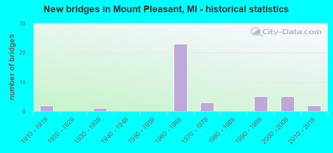
- New bridges - historical statistics
- 21910-1919
- 11930-1939
- 231960-1969
- 31970-1979
- 51990-1999
- 52000-2009
- 22010-2019
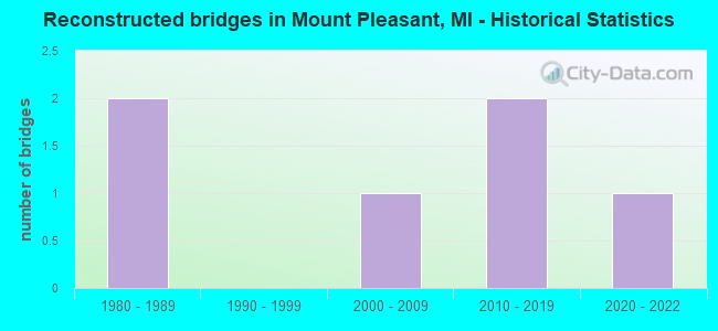
- Reconstructed bridges - Historical Statistics
- 21980-1989
- 01990-1999
- 12000-2009
- 22010-2019
- 12020-2022
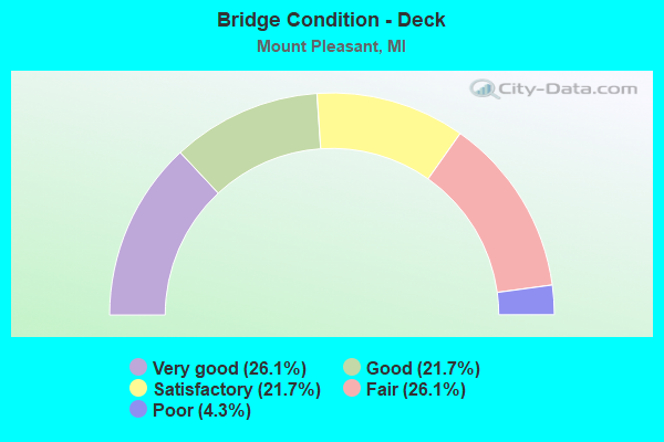
- Bridge Condition - Deck
- 26.1%Very good
- 21.7%Good
- 21.7%Satisfactory
- 26.1%Fair
- 4.3%Poor
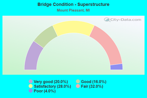
- Bridge Condition - Superstructure
- 20.0%Very good
- 16.0%Good
- 28.0%Satisfactory
- 32.0%Fair
- 4.0%Poor
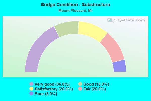
- Bridge Condition - Substructure
- 36.0%Very good
- 16.0%Good
- 20.0%Satisfactory
- 20.0%Fair
- 8.0%Poor
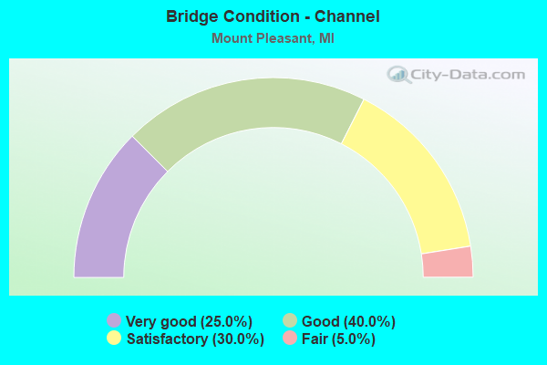
- Bridge Condition - Channel
- 25.0%Very good
- 40.0%Good
- 30.0%Satisfactory
- 5.0%Fair
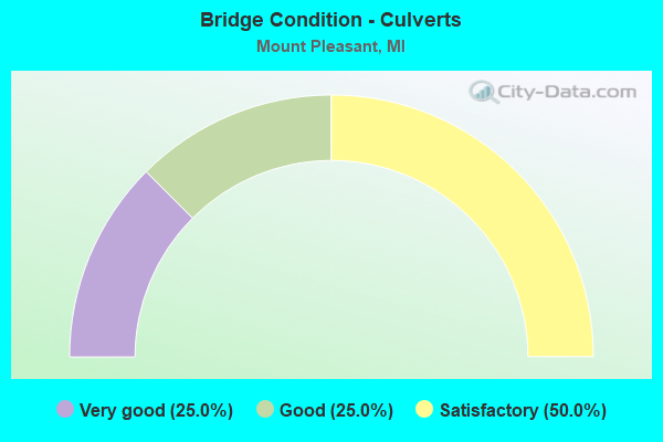
- Bridge Condition - Culverts
- 25.0%Very good
- 25.0%Good
- 50.0%Satisfactory
Find on map >> Show street view
Structure Number: 438, Location: 3 MILES EAST OF ALGER (Lat: 44.141575, Lng: -84.043714), Route carried "on" structure: County highway 690, Year Built: 1963, Status: Open, Structure Length: 6.22m (20.41ft), Average Daily Traffic: 2,100 (year 2017), Truck Traffic: 10%, Average Future Daily Traffic: 3,000 (year 2037), Design Load: HS 20+Mod, Features Intersected: RIFLE RIVER, Facility Carried by Structure: MAPLE RIDGE ROAD
Minimum Vertical Clearance: 30.48m (100.00ft), Kilometerpoint: 7.725, Lanes on structure: 2, Owner: County Highway Agency, Approaching Roadway Width: 9.1m (29.9ft), Material/Design: Steel, Design/Construction: Stringer/Multi-beam, Number Of Spans In Main Unit: 3, Number Of Approach Spans: 2, Length of Maximum Span: 27.4m (89.9ft), Curb-To-Curb Width: 8.5m (27.9ft), Out-to-Out Width: 9.3m (30.5ft)
Condition: Deck: Fair, Superstructure: Poor, Substructure: Fair, Channel: Good, Operating Rating: 64.8 metric tons, Method Used To Determine Operating Rating: Load Factor (LF) rating reported by rating factor (RF) method using MS18 loading, Inventory Rating: 38.9 metric tons, Method Used To Determine Inventory Rating: Load Factor (LF) rating reported by rating factor (RF) method using MS18 loading, Structural Evaluation: Meets minimum limits, Deck Geometry: Meets minimum limits, Waterway Adequacy: Superior to present desirable criteria, Approach Roadway Alignment: Somewhat better than minimum adequacy, Length Of Structure Improvement: 6.22m (20.41ft), Designated Inspection Frequency: Every 12 months, Inspection Date: August 2021, Bridge Improvement Cost: $406,000, Roadway Improvement Cost: $5,000, Total Project Cost: $527,000 ( Estimate for 2017), Deck Structure Type: Concrete Cast-file-Place, Wearing Surface/Protective System: Wearing Surface: Latex Concrete
Find on map >> Show street view
Structure Number: 4234, Location: 4.0 MI S OF M-20 (Lat: 43.559869, Lng: -84.727394), Route carried "on" structure: County highway 3775, Year Built: 1965, Status: Open, Structure Length: 7.38m (24.21ft), Average Daily Traffic: 160 (year 1974), Average Future Daily Traffic: 160 (year 1977), Design Load: H 15, Features Intersected: US-127, Facility Carried by Structure: SUMMERTON RD
Minimum Vertical Clearance: 30.48m (100.00ft), Kilometerpoint: 10.400, Lanes on structure: 2, Lanes under structure: 4, Owner: State Highway Agency, Approaching Roadway Width: 10.3m (33.8ft), Skew: 3 degrees, Material/Design: Steel continuous, Design/Construction: Stringer/Multi-beam, Number Of Spans In Main Unit: 2, Number Of Approach Spans: 2, Length of Maximum Span: 25.7m (84.3ft), Curb or Sidewalk Widths: Left: 0.7m (2.3ft), Right: 0.7m (2.3ft), Curb-To-Curb Width: 7.3m (24.0ft), Out-to-Out Width: 9.5m (31.2ft)
Condition: Deck: Satisfactory, Superstructure: Satisfactory, Substructure: Good, Operating Rating: 65.1 metric tons, Method Used To Determine Operating Rating: Load Factor (LF) rating reported by rating factor (RF) method using MS18 loading, Inventory Rating: 34.3 metric tons, Method Used To Determine Inventory Rating: Load Factor (LF) rating reported by rating factor (RF) method using MS18 loading, Structural Evaluation: Equal to present minimum criteria, Deck Geometry: Somewhat better than minimum adequacy, Underclear: Equal to present minimum criteria, Approach Roadway Alignment: Equal to present desirable criteria, Designated Inspection Frequency: Every 24 months, Inspection Date: April 2021, Deck Structure Type: Concrete Cast-file-Place, Wearing Surface/Protective System: Wearing Surface: Monolithic Concrete
Find on map >> Show street view
Structure Number: 4235, Location: @ S JCT US-127 BR (Lat: 43.564067, Lng: -84.736222), Route carried "on" structure: Business US 127, Year Built: 1961, Year Reconstructed: 2020, Status: Open, Structure Length: 7.07m (23.20ft), Average Daily Traffic: 7,675 (year 2020), Truck Traffic: 3%, Average Future Daily Traffic: 8,475 (year 2040), Design Load: HS 20, Features Intersected: US-127 SB
Minimum Vertical Clearance: 30.48m (100.00ft), Kilometerpoint: 0.256, Lanes on structure: 2, Lanes under structure: 2, Base Highway Network: Yes (Inventory Route: 24, Subroute: 4), Owner: State Highway Agency, Approaching Roadway Width: 12.2m (40.0ft), Skew: 5 degrees, Material/Design: Steel, Design/Construction: Stringer/Multi-beam, Number Of Spans In Main Unit: 3, Length of Maximum Span: 32.8m (107.6ft), Curb-To-Curb Width: 10.1m (33.1ft), Out-to-Out Width: 11.1m (36.4ft)
Condition: Deck: Good, Superstructure: Fair, Substructure: Very good, Operating Rating: 60.9 metric tons, Method Used To Determine Operating Rating: Load Factor (LF) rating reported by rating factor (RF) method using MS18 loading, Inventory Rating: 36.3 metric tons, Method Used To Determine Inventory Rating: Load Factor (LF) rating reported by rating factor (RF) method using MS18 loading, Structural Evaluation: Somewhat better than minimum adequacy, Deck Geometry: Somewhat better than minimum adequacy, Underclear: Meets minimum limits, Approach Roadway Alignment: Equal to present minimum criteria, Designated Inspection Frequency: Every 24 months, Inspection Date: April 2021, Deck Structure Type: Concrete Cast-file-Place, Wearing Surface/Protective System: Wearing Surface: Monolithic Concrete, Deck Protection: Epoxy Coated Reinforcing
Find on map >> Show street view
Structure Number: 4236, Location: 2.0 MI S OF M-20 (Lat: 43.582619, Lng: -84.737861), Route carried "on" structure: County highway 3732, Year Built: 1964, Status: Open, Structure Length: 6.28m (20.60ft), Average Daily Traffic: 5,954 (year 1995), Truck Traffic: 3%, Average Future Daily Traffic: 780 (year 1977), Design Load: H 15, Features Intersected: US-127, Facility Carried by Structure: BROOMFIELD RD
Minimum Vertical Clearance: 30.48m (100.00ft), Kilometerpoint: 7.237, Lanes on structure: 2, Lanes under structure: 4, Owner: State Highway Agency, Approaching Roadway Width: 10.3m (33.8ft), Material/Design: Prestressed concrete, Design/Construction: Stringer/Multi-beam, Number Of Spans In Main Unit: 4, Length of Maximum Span: 21.9m (71.9ft), Curb or Sidewalk Widths: Left: 0.7m (2.3ft), Right: 0.7m (2.3ft), Curb-To-Curb Width: 7.9m (25.9ft), Out-to-Out Width: 10.1m (33.1ft)
Condition: Deck: Satisfactory, Superstructure: Fair, Substructure: Good, Operating Rating: 74.8 metric tons, Method Used To Determine Operating Rating: Load Factor (LF) rating reported by rating factor (RF) method using MS18 loading, Inventory Rating: 35.6 metric tons, Method Used To Determine Inventory Rating: Load Factor (LF) rating reported by rating factor (RF) method using MS18 loading, Structural Evaluation: Somewhat better than minimum adequacy, Deck Geometry: High priority of corrective action, Underclear: Somewhat better than minimum adequacy, Approach Roadway Alignment: Better than present minimum criteria, Designated Inspection Frequency: Every 24 months, Inspection Date: April 2021, Deck Structure Type: Concrete Cast-file-Place, Wearing Surface/Protective System: Wearing Surface: Monolithic Concrete
Find on map >> Show street view
Structure Number: 4237, Location: @ M-20 (Lat: 43.611586, Lng: -84.738250), Route carried "on" structure: US 127, Year Built: 1961, Status: Open, Structure Length: 4.48m (14.70ft), Average Daily Traffic: 6,174 (year 2020), Truck Traffic: 8%, Average Future Daily Traffic: 6,822 (year 2040), Design Load: HS 20, Features Intersected: M-20
Minimum Vertical Clearance: 30.48m (100.00ft), Kilometerpoint: 18.833, Lanes on structure: 3, Lanes under structure: 5, Base Highway Network: Yes (Inventory Route: 24, Subroute: 3), Owner: State Highway Agency, Approaching Roadway Width: 14.3m (46.9ft), Material/Design: Steel, Design/Construction: Stringer/Multi-beam, Number Of Spans In Main Unit: 3, Length of Maximum Span: 24.0m (78.7ft), Curb-To-Curb Width: 16.2m (53.1ft), Out-to-Out Width: 17.3m (56.8ft)
Condition: Deck: Fair, Superstructure: Satisfactory, Substructure: Very good, Operating Rating: 64.8 metric tons, Method Used To Determine Operating Rating: Load Factor (LF) rating reported by rating factor (RF) method using MS18 loading, Inventory Rating: 38.9 metric tons, Method Used To Determine Inventory Rating: Load Factor (LF) rating reported by rating factor (RF) method using MS18 loading, Structural Evaluation: Equal to present minimum criteria, Deck Geometry: Equal to present minimum criteria, Underclear: Better than present minimum criteria, Approach Roadway Alignment: Equal to present desirable criteria, Designated Inspection Frequency: Every 24 months, Inspection Date: January 2021, Deck Structure Type: Concrete Cast-file-Place, Wearing Surface/Protective System: Wearing Surface: Other
Find on map >> Show street view
Structure Number: 4238, Location: @ M-20 (Lat: 43.611589, Lng: -84.738625), Route carried "on" structure: US 127, Year Built: 1961, Status: Open, Structure Length: 4.48m (14.70ft), Average Daily Traffic: 6,174 (year 2020), Truck Traffic: 8%, Average Future Daily Traffic: 6,822 (year 2040), Design Load: HS 20, Features Intersected: M-20
Minimum Vertical Clearance: 30.48m (100.00ft), Kilometerpoint: 18.890, Lanes on structure: 2, Lanes under structure: 5, Base Highway Network: Yes (Inventory Route: 24, Subroute: 6), Owner: State Highway Agency, Approaching Roadway Width: 14.3m (46.9ft), Material/Design: Steel, Design/Construction: Stringer/Multi-beam, Number Of Spans In Main Unit: 3, Length of Maximum Span: 24.0m (78.7ft), Curb-To-Curb Width: 13.2m (43.3ft), Out-to-Out Width: 14.3m (46.9ft)
Condition: Deck: Fair, Superstructure: Satisfactory, Substructure: Good, Operating Rating: 74.8 metric tons, Method Used To Determine Operating Rating: Load Factor (LF) rating reported by rating factor (RF) method using MS18 loading, Inventory Rating: 44.7 metric tons, Method Used To Determine Inventory Rating: Load Factor (LF) rating reported by rating factor (RF) method using MS18 loading, Structural Evaluation: Equal to present minimum criteria, Deck Geometry: Superior to present desirable criteria, Underclear: Somewhat better than minimum adequacy, Approach Roadway Alignment: Equal to present desirable criteria, Designated Inspection Frequency: Every 24 months, Inspection Date: January 2021, Deck Structure Type: Concrete Cast-file-Place, Wearing Surface/Protective System: Wearing Surface: Other, Deck Protection: Epoxy Coated Reinforcing
Find on map >> Show street view
Structure Number: 4239, Location: 0.7 MI S OF M-20 (Lat: 43.604342, Lng: -84.738122), Route carried "on" structure: County highway , Year Built: 1965, Status: Open, Structure Length: 6.28m (20.60ft), Average Daily Traffic: 6,190 (year 1997), Truck Traffic: 3%, Average Future Daily Traffic: 230 (year 1977), Design Load: H 15, Features Intersected: US-127, Facility Carried by Structure: BROADWAY RD
Minimum Vertical Clearance: 30.48m (100.00ft), Kilometerpoint: 4.815, Lanes on structure: 2, Lanes under structure: 4, Owner: State Highway Agency, Approaching Roadway Width: 10.3m (33.8ft), Material/Design: Prestressed concrete, Design/Construction: Stringer/Multi-beam, Number Of Spans In Main Unit: 4, Length of Maximum Span: 21.9m (71.9ft), Curb or Sidewalk Widths: Left: 0.7m (2.3ft), Right: 0.7m (2.3ft), Curb-To-Curb Width: 8.5m (27.9ft), Out-to-Out Width: 10.7m (35.1ft)
Condition: Deck: Fair, Superstructure: Fair, Substructure: Poor, Operating Rating: 65.1 metric tons, Method Used To Determine Operating Rating: Load Factor (LF) rating reported by rating factor (RF) method using MS18 loading, Inventory Rating: 33.7 metric tons, Method Used To Determine Inventory Rating: Load Factor (LF) rating reported by rating factor (RF) method using MS18 loading, Structural Evaluation: Meets minimum limits, Deck Geometry: Meets minimum limits, Underclear: High priority of corrective action, Approach Roadway Alignment: Better than present minimum criteria, Designated Inspection Frequency: Every 24 months, Other Special Inspection Frequency: Every 12 months, Inspection Date: Febuary 2022, Other Special Inspection Date: Febuary 2022, Deck Structure Type: Concrete Cast-file-Place, Wearing Surface/Protective System: Wearing Surface: Monolithic Concrete
Find on map >> Show street view
Structure Number: 424, Location: 1.9 MI NW OF M-20 (Lat: 43.632100, Lng: -84.758550), Route carried "on" structure: US 127, Year Built: 1961, Status: Open, Structure Length: 6.12m (20.08ft), Average Daily Traffic: 8,625 (year 2007), Truck Traffic: 9%, Average Future Daily Traffic: 12,174 (year 2018), Design Load: HS 20, Features Intersected: CHIPPEWA RIVER
Minimum Vertical Clearance: 30.48m (100.00ft), Kilometerpoint: 21.949, Lanes on structure: 2, Base Highway Network: Yes (Inventory Route: 24, Subroute: 3), Owner: State Highway Agency, Approaching Roadway Width: 7.3m (24.0ft), Skew: 3 degrees, Material/Design: Steel, Design/Construction: Stringer/Multi-beam, Number Of Spans In Main Unit: 3, Length of Maximum Span: 20.4m (66.9ft), Curb-To-Curb Width: 9.8m (32.2ft), Out-to-Out Width: 10.9m (35.8ft)
Condition: Deck: Poor, Superstructure: Fair, Substructure: Satisfactory, Channel: Very good, Operating Rating: 58.0 metric tons, Method Used To Determine Operating Rating: Load Factor (LF) rating reported by rating factor (RF) method using MS18 loading, Inventory Rating: 34.7 metric tons, Method Used To Determine Inventory Rating: Load Factor (LF) rating reported by rating factor (RF) method using MS18 loading, Structural Evaluation: Somewhat better than minimum adequacy, Deck Geometry: Meets minimum limits, Waterway Adequacy: Equal to present desirable criteria, Approach Roadway Alignment: Equal to present desirable criteria, Designated Inspection Frequency: Every 24 months, Underwater Inspection Frequency: Every 60 months, Other Special Inspection Frequency: Every 12 months, Inspection Date: July 2021, Underwater Inspection Date: July 2020, Other Special Inspection Date: July 2021, Deck Structure Type: Concrete Cast-file-Place, Wearing Surface/Protective System: Wearing Surface: Latex Concrete
Find on map >> Show street view
Structure Number: 4241, Location: 1.9 MI NW OF M-20 (Lat: 43.631964, Lng: -84.758911), Route carried "on" structure: US 127, Year Built: 1961, Year Reconstructed: 2000, Status: Open, Structure Length: 6.12m (20.08ft), Average Daily Traffic: 8,625 (year 2007), Truck Traffic: 9%, Average Future Daily Traffic: 12,174 (year 2018), Design Load: HS 25 or greater, Features Intersected: CHIPPEWA RIVER
Minimum Vertical Clearance: 30.48m (100.00ft), Kilometerpoint: 22.038, Lanes on structure: 2, Base Highway Network: Yes (Inventory Route: 24, Subroute: 6), Owner: State Highway Agency, Approaching Roadway Width: 10.7m (35.1ft), Skew: 3 degrees, Material/Design: Steel, Design/Construction: Stringer/Multi-beam, Number Of Spans In Main Unit: 3, Length of Maximum Span: 20.4m (66.9ft), Curb-To-Curb Width: 10.7m (35.1ft), Out-to-Out Width: 11.8m (38.7ft)
Condition: Deck: Good, Superstructure: Fair, Substructure: Satisfactory, Channel: Good, Operating Rating: 83.9 metric tons, Method Used To Determine Operating Rating: Load Factor (LF) rating reported by rating factor (RF) method using MS18 loading, Inventory Rating: 50.2 metric tons, Method Used To Determine Inventory Rating: Load Factor (LF) rating reported by rating factor (RF) method using MS18 loading, Structural Evaluation: Somewhat better than minimum adequacy, Deck Geometry: Somewhat better than minimum adequacy, Waterway Adequacy: Better than present minimum criteria, Approach Roadway Alignment: Better than present minimum criteria, Designated Inspection Frequency: Every 24 months, Underwater Inspection Frequency: Every 60 months, Other Special Inspection Frequency: Every 12 months, Inspection Date: July 2021, Underwater Inspection Date: July 2020, Other Special Inspection Date: July 2021, Deck Structure Type: Concrete Cast-file-Place, Wearing Surface/Protective System: Wearing Surface: Monolithic Concrete, Deck Protection: Epoxy Coated Reinforcing
Find on map >> Show street view
Structure Number: 4249, Location: 0.1 MI N OF US-127 BR (Lat: 43.626633, Lng: -84.758617), Route carried "on" structure: US 127, Year Built: 1961, Status: Open, Structure Length: 5.79m (19.00ft), Average Daily Traffic: 8,625 (year 2007), Truck Traffic: 9%, Average Future Daily Traffic: 12,174 (year 2018), Design Load: HS 20, Features Intersected: EAST RIVER RD
Minimum Vertical Clearance: 30.48m (100.00ft), Kilometerpoint: 21.342, Lanes on structure: 3, Lanes under structure: 2, Base Highway Network: Yes (Inventory Route: 24, Subroute: 3), Owner: State Highway Agency, Approaching Roadway Width: 7.3m (24.0ft), Skew: 14 degrees, Material/Design: Steel, Design/Construction: Stringer/Multi-beam, Number Of Spans In Main Unit: 3, Length of Maximum Span: 19.8m (65.0ft), Curb-To-Curb Width: 13.3m (43.6ft), Out-to-Out Width: 14.6m (47.9ft)
Condition: Deck: Fair, Superstructure: Fair, Substructure: Fair, Operating Rating: 59.9 metric tons, Method Used To Determine Operating Rating: Load Factor (LF) rating reported by rating factor (RF) method using MS18 loading, Inventory Rating: 36.0 metric tons, Method Used To Determine Inventory Rating: Load Factor (LF) rating reported by rating factor (RF) method using MS18 loading, Structural Evaluation: Somewhat better than minimum adequacy, Deck Geometry: Somewhat better than minimum adequacy, Underclear: Meets minimum limits, Approach Roadway Alignment: Better than present minimum criteria, Designated Inspection Frequency: Every 24 months, Other Special Inspection Frequency: Every 12 months, Inspection Date: July 2021, Other Special Inspection Date: July 2021, Deck Structure Type: Concrete Cast-file-Place, Wearing Surface/Protective System: Wearing Surface: Latex Concrete
Find on map >> Show street view
Structure Number: 425, Location: 0.1 MI N OF US-127 BR (Lat: 43.626328, Lng: -84.759000), Route carried "on" structure: US 127, Year Built: 1961, Status: Temporarily open, Structure Length: 6.03m (19.78ft), Average Daily Traffic: 8,625 (year 2007), Truck Traffic: 9%, Average Future Daily Traffic: 12,174 (year 2018), Design Load: HS 20, Features Intersected: EAST RIVER RD
Minimum Vertical Clearance: 30.48m (100.00ft), Kilometerpoint: 21.411, Lanes on structure: 3, Lanes under structure: 2, Base Highway Network: Yes (Inventory Route: 24, Subroute: 6), Owner: State Highway Agency, Approaching Roadway Width: 7.3m (24.0ft), Skew: 14 degrees, Material/Design: Steel, Design/Construction: Stringer/Multi-beam, Number Of Spans In Main Unit: 3, Length of Maximum Span: 20.1m (65.9ft), Curb-To-Curb Width: 13.3m (43.6ft), Out-to-Out Width: 14.6m (47.9ft)
Condition: Deck: Fair, Superstructure: Satisfactory, Substructure: Poor, Structural Evaluation: High priority of corrective action, Deck Geometry: Somewhat better than minimum adequacy, Underclear: Meets minimum limits, Approach Roadway Alignment: Better than present minimum criteria, Designated Inspection Frequency: Every 24 months, Other Special Inspection Frequency: Every 12 months, Inspection Date: July 2021, Other Special Inspection Date: July 2021, Deck Structure Type: Concrete Cast-file-Place, Wearing Surface/Protective System: Wearing Surface: Latex Concrete
Find on map >> Show street view
Structure Number: 4265, Location: IN MT PLEASANT (Lat: 43.597092, Lng: -84.786247), Route carried "on" structure: State highway 20, Year Built: 1996, Status: Open, Structure Length: 3.96m (12.99ft), Average Daily Traffic: 10,842 (year 2007), Truck Traffic: 3%, Average Future Daily Traffic: 17,709 (year 2018), Design Load: H 15, Features Intersected: CHIPPEWA RIVER
Minimum Vertical Clearance: 30.48m (100.00ft), Kilometerpoint: 24.205, Lanes on structure: 4, Owner: State Highway Agency, Approaching Roadway Width: 13.4m (44.0ft), Material/Design: Prestressed concrete, Design/Construction: Stringer/Multi-beam, Number Of Spans In Main Unit: 1, Length of Maximum Span: 38.3m (125.7ft), Curb or Sidewalk Widths: Left: 1.5m (4.9ft), Right: 1.5m (4.9ft), Curb-To-Curb Width: 15.8m (51.8ft), Out-to-Out Width: 19.8m (65.0ft)
Condition: Deck: Good, Superstructure: Good, Substructure: Very good, Channel: Good, Operating Rating: 97.2 metric tons, Method Used To Determine Operating Rating: Load Factor (LF) rating reported by rating factor (RF) method using MS18 loading, Inventory Rating: 45.0 metric tons, Method Used To Determine Inventory Rating: Load Factor (LF) rating reported by rating factor (RF) method using MS18 loading, Structural Evaluation: Better than present minimum criteria, Deck Geometry: Meets minimum limits, Waterway Adequacy: Better than present minimum criteria, Approach Roadway Alignment: Equal to present desirable criteria, Designated Inspection Frequency: Every 24 months, Inspection Date: March 2021, Deck Structure Type: Concrete Cast-file-Place, Wearing Surface/Protective System: Wearing Surface: Latex Concrete, Membrane: Epoxy, Deck Protection: Epoxy Coated Reinforcing
Find on map >> Show street view
Structure Number: 4281, Location: 50 FT E OF MISSION RD (Lat: 43.640556, Lng: -84.767778), Route carried "on" structure: County highway 3748, Year Built: 2009, Status: Open, Structure Length: 0.85m (2.79ft), Average Daily Traffic: 427 (year 2004), Truck Traffic: 5%, Average Future Daily Traffic: 1,960 (year 2023), Design Load: HS 20, Features Intersected: JOHN NEFF DRAIN, Facility Carried by Structure: BASE LINE ROAD
Minimum Vertical Clearance: 30.48m (100.00ft), Kilometerpoint: 6.273, Lanes on structure: 2, Owner: County Highway Agency, Approaching Roadway Width: 10.4m (34.1ft), Skew: 3 degrees, Material/Design: Concrete, Design/Construction: Culvert, Number Of Spans In Main Unit: 1, Length of Maximum Span: 8.5m (27.9ft)
Condition: Channel: Good, Culverts: Very good, Operating Rating: 43.6 metric tons, Method Used To Determine Operating Rating: Field evaluation and documented engineering judgment, Inventory Rating: 32.7 metric tons, Method Used To Determine Inventory Rating: Field evaluation and documented engineering judgment, Structural Evaluation: Equal to present desirable criteria, Waterway Adequacy: Equal to present desirable criteria, Approach Roadway Alignment: Equal to present desirable criteria, Designated Inspection Frequency: Every 24 months, Inspection Date: June 2020, Wearing Surface/Protective System: Wearing Surface: Bituminous
Find on map >> Show street view
Structure Number: 4302, Location: 0.1M N SW COR SEC 21 T14N (Lat: 43.587675, Lng: -84.807514), Route carried "on" structure: County highway 2024, Year Built: 2017, Status: Open, Structure Length: 5.00m (16.40ft), Average Daily Traffic: 6,666 (year 2015), Truck Traffic: 5%, Average Future Daily Traffic: 10,925 (year 2034), Design Load: Greater than HL93, Features Intersected: CHIPPEWA RIVER, Facility Carried by Structure: LINCOLN ROAD
Minimum Vertical Clearance: 30.48m (100.00ft), Kilometerpoint: 3.842, Lanes on structure: 3, Owner: County Highway Agency, Approaching Roadway Width: 15.1m (49.5ft), Skew: 4 degrees, Material/Design: Prestressed concrete, Design/Construction: Box Beam or Girders - Multiple, Number Of Spans In Main Unit: 3, Length of Maximum Span: 26.7m (87.6ft), Curb-To-Curb Width: 15.2m (49.9ft), Out-to-Out Width: 16.2m (53.1ft)
Condition: Deck: Very good, Superstructure: Very good, Substructure: Very good, Channel: Very good, Operating Rating: 77.4 metric tons, Method Used To Determine Operating Rating: Load and Resistance Factor Rating (LRFR) rating reported by rating factor(RF) method using HL-93 loadings, Inventory Rating: 59.6 metric tons, Method Used To Determine Inventory Rating: Load and Resistance Factor Rating (LRFR) rating reported by rating factor(RF) method using HL-93 loadings, Structural Evaluation: Equal to present desirable criteria, Deck Geometry: Equal to present minimum criteria, Waterway Adequacy: Better than present minimum criteria, Approach Roadway Alignment: Equal to present desirable criteria, Designated Inspection Frequency: Every 24 months, Inspection Date: July 2021, Deck Structure Type: Concrete Cast-file-Place, Wearing Surface/Protective System: Wearing Surface: Monolithic Concrete, Deck Protection: Epoxy Coated Reinforcing
Find on map >> Show street view
Structure Number: 4305, Location: AT SE COR SEC 6 T14N R3W (Lat: 43.626325, Lng: -84.708058), Route carried "on" structure: County highway 3746, Year Built: 1969, Status: Open, Structure Length: 4.57m (14.99ft), Average Daily Traffic: 2,516 (year 2002), Average Future Daily Traffic: 3,740 (year 2022), Design Load: H 20, Features Intersected: NORTH BR CHIPPEWA RIVER, Facility Carried by Structure: LEATON ROAD
Minimum Vertical Clearance: 30.48m (100.00ft), Kilometerpoint: 8.322, Lanes on structure: 2, Owner: County Highway Agency, Approaching Roadway Width: 10.4m (34.1ft), Skew: 4 degrees, Material/Design: Prestressed concrete, Design/Construction: Box Beam or Girders - Multiple, Number Of Spans In Main Unit: 3, Length of Maximum Span: 15.2m (49.9ft), Curb-To-Curb Width: 10.1m (33.1ft), Out-to-Out Width: 10.1m (33.1ft)
Condition: Deck: Satisfactory, Superstructure: Fair, Substructure: Fair, Channel: Satisfactory, Operating Rating: 54.0 metric tons, Method Used To Determine Operating Rating: Load Factor (LF), Inventory Rating: 32.3 metric tons, Method Used To Determine Inventory Rating: Load Factor (LF), Structural Evaluation: Somewhat better than minimum adequacy, Deck Geometry: Meets minimum limits, Waterway Adequacy: Equal to present desirable criteria, Approach Roadway Alignment: Equal to present desirable criteria, Designated Inspection Frequency: Every 24 months, Inspection Date: June 2020, Deck Structure Type: Concrete Precast Panels, Wearing Surface/Protective System: Wearing Surface: Bituminous
Find on map >> Show street view
Structure Number: 4309, Location: 0.1M N SE COR SEC 27 T14N (Lat: 43.569853, Lng: -84.767319), Route carried "on" structure: County highway 2024, Year Built: 2005, Status: Open, Structure Length: 1.97m (6.46ft), Average Daily Traffic: 9,200 (year 2004), Truck Traffic: 2%, Average Future Daily Traffic: 15,075 (year 2024), Design Load: H 20, Features Intersected: ANN ARBOR RAILROAD, Facility Carried by Structure: MISSION ROAD
Minimum Vertical Clearance: 30.48m (100.00ft), Kilometerpoint: 11.605, Lanes on structure: 2, Owner: County Highway Agency, Approaching Roadway Width: 12.2m (40.0ft), Skew: 2 degrees, Material/Design: Prestressed concrete, Design/Construction: Box Beam or Girders - Multiple, Number Of Spans In Main Unit: 1, Length of Maximum Span: 18.2m (59.7ft), Curb-To-Curb Width: 12.5m (41.0ft), Out-to-Out Width: 13.4m (44.0ft)
Condition: Deck: Very good, Superstructure: Very good, Substructure: Very good, Operating Rating: 63.1 metric tons, Method Used To Determine Operating Rating: Load Factor (LF), Inventory Rating: 37.8 metric tons, Method Used To Determine Inventory Rating: Load Factor (LF), Structural Evaluation: Equal to present desirable criteria, Deck Geometry: Somewhat better than minimum adequacy, Underclear: Superior to present desirable criteria, Approach Roadway Alignment: Equal to present minimum criteria, Designated Inspection Frequency: Every 24 months, Inspection Date: June 2020, Deck Structure Type: Concrete Cast-file-Place, Wearing Surface/Protective System: Wearing Surface: Monolithic Concrete, Membrane: Other, Deck Protection: Epoxy Coated Reinforcing
Find on map >> Show street view
Structure Number: 431, Location: 0.1 M S NE COR SEC 10 T14 (Lat: 43.624942, Lng: -84.767917), Route carried "on" structure: County highway 2024, Year Built: 2008, Status: Open, Structure Length: 4.15m (13.62ft), Average Daily Traffic: 9,019 (year 2008), Truck Traffic: 5%, Average Future Daily Traffic: 13,402 (year 2028), Features Intersected: NORTH BR CHIPPEWA RIVER, Facility Carried by Structure: MISSION ROAD
Minimum Vertical Clearance: 30.48m (100.00ft), Kilometerpoint: 0.914, Lanes on structure: 2, Owner: County Highway Agency, Approaching Roadway Width: 12.8m (42.0ft), Skew: 3 degrees, Material/Design: Prestressed concrete, Design/Construction: Box Beam or Girders - Multiple, Number Of Spans In Main Unit: 1, Length of Maximum Span: 41.1m (134.8ft), Curb-To-Curb Width: 13.1m (43.0ft), Out-to-Out Width: 13.8m (45.3ft)
Condition: Deck: Good, Superstructure: Good, Substructure: Very good, Channel: Very good, Inventory Rating: 87.0 metric tons, Method Used To Determine Inventory Rating: Load Factor (LF), Structural Evaluation: Better than present minimum criteria, Deck Geometry: Somewhat better than minimum adequacy, Waterway Adequacy: Equal to present desirable criteria, Approach Roadway Alignment: Equal to present desirable criteria, Designated Inspection Frequency: Every 24 months, Inspection Date: June 2020, Deck Structure Type: Concrete Cast-file-Place, Wearing Surface/Protective System: Wearing Surface: Monolithic Concrete, Deck Protection: Epoxy Coated Reinforcing
Find on map >> Show street view
Structure Number: 4313, Location: 0.1M S NE COR SEC 20 T14N (Lat: 43.595911, Lng: -84.687850), Route carried "on" structure: County highway 3783, Year Built: 1995, Status: Open, Structure Length: 1.31m (4.30ft), Average Daily Traffic: 4,001 (year 2018), Truck Traffic: 2%, Average Future Daily Traffic: 4,883 (year 2038), Design Load: HS 20, Features Intersected: ONION CREEK DRAIN, Facility Carried by Structure: SHEPHERD ROAD
Minimum Vertical Clearance: 30.48m (100.00ft), Kilometerpoint: 14.417, Lanes on structure: 2, Owner: County Highway Agency, Approaching Roadway Width: 8.5m (27.9ft), Skew: 1 degrees, Material/Design: Prestressed concrete, Design/Construction: Box Beam or Girders - Multiple, Number Of Spans In Main Unit: 1, Length of Maximum Span: 12.7m (41.7ft), Curb-To-Curb Width: 9.8m (32.2ft), Out-to-Out Width: 10.5m (34.4ft)
Condition: Deck: Good, Superstructure: Very good, Substructure: Satisfactory, Channel: Good, Operating Rating: 66.9 metric tons, Method Used To Determine Operating Rating: Load Factor (LF), Inventory Rating: 40.1 metric tons, Method Used To Determine Inventory Rating: Load Factor (LF), Structural Evaluation: Equal to present minimum criteria, Deck Geometry: Meets minimum limits, Waterway Adequacy: Better than present minimum criteria, Approach Roadway Alignment: Better than present minimum criteria, Designated Inspection Frequency: Every 24 months, Inspection Date: April 2020, Deck Structure Type: Concrete Cast-file-Place, Wearing Surface/Protective System: Wearing Surface: Epoxy Overlay, Membrane: Epoxy, Deck Protection: Epoxy Coated Reinforcing
Find on map >> Show street view
Structure Number: 4318, Location: 0.5 M N SE COR SEC 2 T14N (Lat: 43.634650, Lng: -84.748183), Route carried "on" structure: County highway 3748, Year Built: 1972, Status: Open, Structure Length: 4.69m (15.39ft), Average Daily Traffic: 1,330 (year 2002), Average Future Daily Traffic: 1,975 (year 2022), Design Load: H 20, Features Intersected: CHIPPEWA RIVER, Facility Carried by Structure: ISABELLA ROAD
Minimum Vertical Clearance: 30.48m (100.00ft), Kilometerpoint: 7.854, Lanes on structure: 2, Owner: County Highway Agency, Approaching Roadway Width: 10.4m (34.1ft), Skew: 1 degrees, Material/Design: Prestressed concrete, Design/Construction: Box Beam or Girders - Multiple, Number Of Spans In Main Unit: 3, Length of Maximum Span: 16.1m (52.8ft), Curb-To-Curb Width: 10.1m (33.1ft), Out-to-Out Width: 10.1m (33.1ft)
Condition: Deck: Satisfactory, Superstructure: Fair, Substructure: Good, Channel: Satisfactory, Operating Rating: 56.9 metric tons, Method Used To Determine Operating Rating: Load Factor (LF), Inventory Rating: 34.1 metric tons, Method Used To Determine Inventory Rating: Load Factor (LF), Structural Evaluation: Somewhat better than minimum adequacy, Deck Geometry: Somewhat better than minimum adequacy, Waterway Adequacy: Better than present minimum criteria, Approach Roadway Alignment: Equal to present minimum criteria, Designated Inspection Frequency: Every 24 months, Inspection Date: April 2020, Deck Structure Type: Concrete Precast Panels, Wearing Surface/Protective System: Wearing Surface: Bituminous, Membrane: Other
Find on map >> Show street view
Structure Number: 4323, Location: 0.3 M E SW COR SEC 16 T14 (Lat: 43.597267, Lng: -84.681592), Route carried "on" structure: County highway , Year Built: 1975, Status: Open, Structure Length: 1.22m (4.00ft), Average Daily Traffic: 620 (year 2002), Average Future Daily Traffic: 756 (year 2002), Design Load: HS 20, Features Intersected: ONION CREEK DRAIN, Facility Carried by Structure: REMUS ROAD
Minimum Vertical Clearance: 30.48m (100.00ft), Kilometerpoint: 2.115, Lanes on structure: 2, Owner: County Highway Agency, Approaching Roadway Width: 10.4m (34.1ft), Skew: 3 degrees, Material/Design: Wood or Timber, Design/Construction: Slab, Number Of Spans In Main Unit: 2, Length of Maximum Span: 6.1m (20.0ft), Curb-To-Curb Width: 9.8m (32.2ft), Out-to-Out Width: 10.2m (33.5ft)
Condition: Deck: Satisfactory, Superstructure: Satisfactory, Substructure: Satisfactory, Channel: Fair, Operating Rating: 47.8 metric tons, Method Used To Determine Operating Rating: Allowable Stress (AS), Inventory Rating: 34.3 metric tons, Method Used To Determine Inventory Rating: Allowable Stress (AS), Structural Evaluation: Equal to present minimum criteria, Deck Geometry: Equal to present minimum criteria, Waterway Adequacy: Equal to present minimum criteria, Approach Roadway Alignment: Equal to present desirable criteria, Designated Inspection Frequency: Every 24 months, Inspection Date: May 2020, Deck Structure Type: Wood or Timber, Wearing Surface/Protective System: Wearing Surface: Bituminous
Find on map >> Show street view
Structure Number: 4324, Location: .35 M S NE COR SEC 8 T14N (Lat: 43.621411, Lng: -84.688028), Route carried "on" structure: County highway , Year Built: 1993, Year Reconstructed: 2019, Status: Open, Structure Length: 5.43m (17.81ft), Average Daily Traffic: 826 (year 2018), Truck Traffic: 3%, Average Future Daily Traffic: 1,007 (year 2038), Design Load: Greater than HL93, Features Intersected: CHIPPEWA RIVER, Facility Carried by Structure: SHEPHERD ROAD
Minimum Vertical Clearance: 30.48m (100.00ft), Kilometerpoint: 17.250, Lanes on structure: 2, Owner: County Highway Agency, Approaching Roadway Width: 9.3m (30.5ft), Material/Design: Prestressed concrete, Design/Construction: Box Beam or Girders - Single/Spread, Number Of Spans In Main Unit: 3, Length of Maximum Span: 18.5m (60.7ft), Curb-To-Curb Width: 9.3m (30.5ft), Out-to-Out Width: 10.2m (33.5ft)
Condition: Deck: Very good, Superstructure: Very good, Substructure: Very good, Channel: Good, Operating Rating: 56.7 metric tons, Method Used To Determine Operating Rating: Load and Resistance Factor Rating (LRFR) rating reported by rating factor(RF) method using HL-93 loadings, Inventory Rating: 43.7 metric tons, Method Used To Determine Inventory Rating: Load and Resistance Factor Rating (LRFR) rating reported by rating factor(RF) method using HL-93 loadings, Structural Evaluation: Equal to present desirable criteria, Deck Geometry: Equal to present minimum criteria, Waterway Adequacy: Equal to present desirable criteria, Approach Roadway Alignment: Equal to present desirable criteria, Designated Inspection Frequency: Every 24 months, Inspection Date: August 2021, Deck Structure Type: Concrete Cast-file-Place, Wearing Surface/Protective System: Wearing Surface: Monolithic Concrete, Deck Protection: Epoxy Coated Reinforcing
Find on map >> Show street view
Structure Number: 4373, Location: SEC 3 UNION TWP (Lat: 43.640567, Lng: -84.783303), Route carried "on" structure: County highway , Year Built: 2004, Status: Open, Structure Length: 1.16m (3.81ft), Average Daily Traffic: 144 (year 2004), Average Future Daily Traffic: 204 (year 2024), Design Load: HS 20, Features Intersected: JOHN NEFF DRAIN, Facility Carried by Structure: BASELINE ROAD
Minimum Vertical Clearance: 30.48m (100.00ft), Kilometerpoint: 14.512, Lanes on structure: 2, Owner: County Highway Agency, Approaching Roadway Width: 7.9m (25.9ft), Material/Design: Concrete, Design/Construction: Culvert, Number Of Spans In Main Unit: 1, Length of Maximum Span: 11.0m (36.1ft), Out-to-Out Width: 8.0m (26.2ft)
Condition: Channel: Satisfactory, Culverts: Good, Operating Rating: 43.5 metric tons, Method Used To Determine Operating Rating: Field evaluation and documented engineering judgment, Inventory Rating: 33.3 metric tons, Method Used To Determine Inventory Rating: Field evaluation and documented engineering judgment, Structural Evaluation: Better than present minimum criteria, Waterway Adequacy: Equal to present desirable criteria, Approach Roadway Alignment: Equal to present desirable criteria, Designated Inspection Frequency: Every 24 months, Inspection Date: June 2020, Wearing Surface/Protective System: Wearing Surface: Monolithic Concrete, Deck Protection: Epoxy Coated Reinforcing
Find on map >> Show street view
Structure Number: 4374, Location: SEC 30W UNION TWP (Lat: 43.577389, Lng: -84.848086), Route carried "on" structure: ServiceCounty highway , Year Built: 2003, Status: Open, Structure Length: 3.29m (10.79ft), Average Daily Traffic: 1,277 (year 2013), Truck Traffic: 4%, Average Future Daily Traffic: 1,558 (year 2033), Design Load: H 20, Features Intersected: SOUTH BR CHIPPEWA RIVER, Facility Carried by Structure: MERIDIAN ROAD
Minimum Vertical Clearance: 30.48m (100.00ft), Kilometerpoint: 1.897, Lanes on structure: 2, Owner: County Highway Agency, Approaching Roadway Width: 12.2m (40.0ft), Material/Design: Prestressed concrete, Design/Construction: Stringer/Multi-beam, Number Of Spans In Main Unit: 1, Length of Maximum Span: 32.0m (105.0ft), Curb-To-Curb Width: 12.2m (40.0ft), Out-to-Out Width: 12.8m (42.0ft)
Condition: Deck: Very good, Superstructure: Good, Substructure: Very good, Channel: Very good, Inventory Rating: 61.0 metric tons, Method Used To Determine Inventory Rating: Load Factor (LF), Structural Evaluation: Better than present minimum criteria, Deck Geometry: Better than present minimum criteria, Waterway Adequacy: Equal to present desirable criteria, Approach Roadway Alignment: High priority of corrective action, Designated Inspection Frequency: Every 24 months, Inspection Date: July 2020, Deck Structure Type: Concrete Cast-file-Place, Wearing Surface/Protective System: Wearing Surface: Integral Concrete, Deck Protection: Epoxy Coated Reinforcing
Find on map >> Show street view
Structure Number: 4375, Location: SEC 19W UNION TWP (Lat: 43.592694, Lng: -84.847922), Route carried "on" structure: ServiceCounty highway , Year Built: 2018, Status: Open, Structure Length: 1.83m (6.00ft), Average Daily Traffic: 1,533 (year 2017), Truck Traffic: 3%, Average Future Daily Traffic: 1,870 (year 2037), Design Load: Greater than HL93, Features Intersected: NORTH BR CHIPPEWA RIVER, Facility Carried by Structure: MERIDIAN ROAD
Minimum Vertical Clearance: 30.48m (100.00ft), Kilometerpoint: 3.592, Lanes on structure: 2, Owner: County Highway Agency, Approaching Roadway Width: 11.0m (36.1ft), Skew: 1 degrees, Material/Design: Prestressed concrete, Design/Construction: Stringer/Multi-beam, Number Of Spans In Main Unit: 1, Length of Maximum Span: 17.5m (57.4ft), Curb-To-Curb Width: 11.1m (36.4ft), Out-to-Out Width: 12.0m (39.4ft)
Condition: Deck: Very good, Superstructure: Very good, Substructure: Very good, Channel: Very good, Operating Rating: 77.1 metric tons, Method Used To Determine Operating Rating: Load and Resistance Factor Rating (LRFR) rating reported by rating factor(RF) method using HL-93 loadings, Inventory Rating: 59.6 metric tons, Method Used To Determine Inventory Rating: Load and Resistance Factor Rating (LRFR) rating reported by rating factor(RF) method using HL-93 loadings, Structural Evaluation: Equal to present desirable criteria, Deck Geometry: Equal to present minimum criteria, Waterway Adequacy: Equal to present desirable criteria, Approach Roadway Alignment: Better than present minimum criteria, Designated Inspection Frequency: Every 24 months, Inspection Date: July 2020, Deck Structure Type: Concrete Cast-file-Place, Wearing Surface/Protective System: Wearing Surface: Monolithic Concrete, Deck Protection: Epoxy Coated Reinforcing
Find on map >> Show street view
Structure Number: 4378, Location: IN MT PLEASANT (Lat: 43.604486, Lng: -84.782358), Route carried "on" structure: City street 2024, Year Built: 1910, Year Reconstructed: 1988, Status: Open, Structure Length: 2.86m (9.38ft), Average Daily Traffic: 2,352 (year 2019), Truck Traffic: 2%, Average Future Daily Traffic: 2,870 (year 2039), Features Intersected: CHIPPEWA RIVER, Facility Carried by Structure: BROADWAY ST
Minimum Vertical Clearance: 30.48m (100.00ft), Kilometerpoint: 1.244, Lanes on structure: 2, Owner: City or Municipal Highway Agency, Approaching Roadway Width: 13.4m (44.0ft), Material/Design: Concrete, Design/Construction: Arch - Deck, Number Of Spans In Main Unit: 1, Length of Maximum Span: 26.8m (87.9ft), Curb or Sidewalk Widths: Left: 0.0m, Right: 1.7m (5.6ft), Curb-To-Curb Width: 10.7m (35.1ft), Out-to-Out Width: 13.3m (43.6ft)
Condition: Superstructure: Satisfactory, Substructure: Fair, Channel: Satisfactory, Operating Rating: 55.5 metric tons, Method Used To Determine Operating Rating: Field evaluation and documented engineering judgment, Inventory Rating: 33.3 metric tons, Method Used To Determine Inventory Rating: Field evaluation and documented engineering judgment, Structural Evaluation: Somewhat better than minimum adequacy, Deck Geometry: Somewhat better than minimum adequacy, Waterway Adequacy: Somewhat better than minimum adequacy, Approach Roadway Alignment: Better than present minimum criteria, Designated Inspection Frequency: Every 24 months, Inspection Date: March 2022, Deck Structure Type: Concrete Cast-file-Place, Wearing Surface/Protective System: Wearing Surface: Bituminous
Find on map >> Show street view
Structure Number: 4379, Location: IN MT PLEASANT (Lat: 43.611831, Lng: -84.778786), Route carried "on" structure: City street 2024, Year Built: 1979, Year Reconstructed: 2017, Status: Open, Structure Length: 4.05m (13.29ft), Average Daily Traffic: 16,211 (year 2016), Truck Traffic: 6%, Average Future Daily Traffic: 19,761 (year 2036), Design Load: HS 20, Features Intersected: CHIPPEWA RIVER, Facility Carried by Structure: PICKARD AVENUE
Minimum Vertical Clearance: 30+ m (98+ ft), Kilometerpoint: 21.653, Lanes on structure: 4, Owner: City or Municipal Highway Agency, Approaching Roadway Width: 14.6m (47.9ft), Skew: 2 degrees, Material/Design: Prestressed concrete, Design/Construction: Box Beam or Girders - Multiple, Number Of Spans In Main Unit: 3, Length of Maximum Span: 19.1m (62.7ft), Curb or Sidewalk Widths: Left: 2.1m (6.9ft), Right: 2.1m (6.9ft), Curb-To-Curb Width: 14.6m (47.9ft), Out-to-Out Width: 18.7m (61.4ft)
Condition: Deck: Very good, Superstructure: Good, Substructure: Satisfactory, Channel: Good, Operating Rating: 73.2 metric tons, Method Used To Determine Operating Rating: Load Factor (LF) rating reported by rating factor (RF) method using MS18 loading, Inventory Rating: 44.1 metric tons, Method Used To Determine Inventory Rating: Load Factor (LF) rating reported by rating factor (RF) method using MS18 loading, Structural Evaluation: Equal to present minimum criteria, Deck Geometry: High priority of replacement, Waterway Adequacy: Equal to present desirable criteria, Approach Roadway Alignment: Equal to present desirable criteria, Designated Inspection Frequency: Every 24 months, Inspection Date: July 2020, Deck Structure Type: Concrete Cast-file-Place, Wearing Surface/Protective System: Wearing Surface: Monolithic Concrete, Deck Protection: Epoxy Coated Reinforcing
Find on map >> Show street view
Structure Number: 438, Location: IN MT PLEASANT (Lat: 43.607214, Lng: -84.777586), Route carried "on" structure: City street , Year Built: 1910, Year Reconstructed: 1994, Status: Posted for load, Structure Length: 2.31m (7.58ft), Average Daily Traffic: 2,161 (year 2019), Truck Traffic: 2%, Average Future Daily Traffic: 2,637 (year 2039), Features Intersected: CHIPPEWA RIVER CHANNEL, Facility Carried by Structure: LINCOLN ST
Minimum Vertical Clearance: 30.48m (100.00ft), Kilometerpoint: 0.072, Lanes on structure: 2, Owner: City or Municipal Highway Agency, Approaching Roadway Width: 10.7m (35.1ft), Material/Design: Concrete, Design/Construction: Arch - Deck, Number Of Spans In Main Unit: 1, Length of Maximum Span: 21.3m (69.9ft), Curb or Sidewalk Widths: Left: 0.0m, Right: 2.8m (9.2ft), Curb-To-Curb Width: 7.6m (24.9ft), Out-to-Out Width: 11.2m (36.7ft)
Condition: Superstructure: Satisfactory, Substructure: Fair, Channel: Satisfactory, Operating Rating: 54.5 metric tons, Method Used To Determine Operating Rating: Field evaluation and documented engineering judgment, Inventory Rating: 32.7 metric tons, Method Used To Determine Inventory Rating: Field evaluation and documented engineering judgment, Structural Evaluation: Somewhat better than minimum adequacy, Deck Geometry: High priority of replacement, Waterway Adequacy: Equal to present minimum criteria, Approach Roadway Alignment: Equal to present minimum criteria, Bridge Posting: Required (Relationship of Operating Rating to Maximum Legal Load: 30.0 - 39.9% below), Designated Inspection Frequency: Every 24 months, Inspection Date: July 2020, Deck Structure Type: Concrete Cast-file-Place, Wearing Surface/Protective System: Wearing Surface: Bituminous
Find on map >> Show street view
Structure Number: F52, Location: SAGINAW CHIPPEWA RES. (Lat: 43.594917, Lng: -84.706381), Route carried "on" structure: Federal lands road 12, Year Built: 1998, Status: Open, Structure Length: 0.61m (2.00ft), Average Daily Traffic: 60 (year 2021), Truck Traffic: 10%, Average Future Daily Traffic: 100 (year 2041), Design Load: HS 20, Features Intersected: NEFF EXTENSION DRAIN
Minimum Vertical Clearance: 30+ m (98+ ft), Kilometerpoint: 0.000, Lanes on structure: 2, Owner: Bureau of Indian Affairs, Approaching Roadway Width: 8.2m (26.9ft), Skew: 3 degrees, Material/Design: Concrete, Design/Construction: Culvert, Number Of Spans In Main Unit: 1, Length of Maximum Span: 6.1m (20.0ft), Curb or Sidewalk Widths: Left: 1.8m (5.9ft), Right: 1.8m (5.9ft), Curb-To-Curb Width: 8.2m (26.9ft), Out-to-Out Width: 19.5m (64.0ft)
Condition: Channel: Good, Culverts: Satisfactory, Operating Rating: 49.0 metric tons, Method Used To Determine Operating Rating: Load Factor (LF), Inventory Rating: 32.7 metric tons, Method Used To Determine Inventory Rating: Load Factor (LF), Structural Evaluation: Equal to present minimum criteria, Deck Geometry: Equal to present minimum criteria, Waterway Adequacy: Better than present minimum criteria, Approach Roadway Alignment: Equal to present minimum criteria, Designated Inspection Frequency: Every 24 months, Inspection Date: September 2021
Find on map >> Show street view
Structure Number: F521, Location: SAGINAW CHIPPEWA RES. (Lat: 43.595372, Lng: -84.703450), Route carried "on" structure: Federal lands road 11, Year Built: 1998, Status: Open, Structure Length: 1.12m (3.67ft), Average Daily Traffic: 60 (year 2021), Truck Traffic: 10%, Average Future Daily Traffic: 100 (year 2039), Design Load: HS 20, Features Intersected: ONION CREEK DRAIN
Minimum Vertical Clearance: 30+ m (98+ ft), Kilometerpoint: 0.300, Lanes on structure: 2, Owner: Bureau of Indian Affairs, Approaching Roadway Width: 8.4m (27.6ft), Skew: 3 degrees, Material/Design: Concrete, Design/Construction: Culvert, Number Of Spans In Main Unit: 1, Length of Maximum Span: 11.2m (36.7ft), Curb or Sidewalk Widths: Left: 1.8m (5.9ft), Right: 1.8m (5.9ft), Curb-To-Curb Width: 8.4m (27.6ft), Out-to-Out Width: 23.8m (78.1ft)
Condition: Channel: Satisfactory, Culverts: Satisfactory, Operating Rating: 49.0 metric tons, Method Used To Determine Operating Rating: Load Factor (LF), Inventory Rating: 32.7 metric tons, Method Used To Determine Inventory Rating: Load Factor (LF), Structural Evaluation: Equal to present minimum criteria, Deck Geometry: Equal to present minimum criteria, Waterway Adequacy: Equal to present minimum criteria, Approach Roadway Alignment: Equal to present minimum criteria, Designated Inspection Frequency: Every 24 months, Inspection Date: September 2021
Find on map >> Show street view
Structure Number: 4234, Location: 4.0 MI S OF M-20 (Lat: 43.559869, Lng: -84.727394), Route carried "under" structure: US 127, Year Built: 1965, Structure Length: 0. m, Average Daily Traffic: 20,914 (year 2007), Truck Traffic: 7%, Features Intersected: US-127, Facility Carried by Structure: SUMMERTON RD
Minimum Vertical Clearance: 5.26m (17.26ft), Kilometerpoint: 12.740, Lanes on structure: 2, Lanes under structure: 4, Material/Design: Steel continuous, Design/Construction: Stringer/Multi-beam, Length of Maximum Span: 25.7m (84.3ft)
Find on map >> Show street view
Structure Number: 4235, Location: @ S JCT US-127 BR (Lat: 43.564067, Lng: -84.736222), Route carried "under" structure: US 127, Year Built: 1961, Structure Length: 0. m, Average Daily Traffic: 8,788 (year 2020), Truck Traffic: 6%, Features Intersected: US-127 SB
Minimum Vertical Clearance: 4.52m (14.83ft), Kilometerpoint: 13.574, Lanes on structure: 2, Lanes under structure: 2, Material/Design: Steel, Design/Construction: Stringer/Multi-beam, Length of Maximum Span: 32.8m (107.6ft)
Find on map >> Show street view
Structure Number: 4236, Location: 2.0 MI S OF M-20 (Lat: 43.582619, Lng: -84.737861), Route carried "under" structure: US 127, Year Built: 1964, Structure Length: 0. m, Average Daily Traffic: 13,562 (year 2007), Truck Traffic: 12%, Features Intersected: US-127, Facility Carried by Structure: BROOMFIELD RD
Minimum Vertical Clearance: 4.47m (14.67ft), Kilometerpoint: 15.616, Lanes on structure: 2, Lanes under structure: 4, Material/Design: Prestressed concrete, Design/Construction: Stringer/Multi-beam, Length of Maximum Span: 21.9m (71.9ft)
Find on map >> Show street view
Structure Number: 4237, Location: @ M-20 (Lat: 43.611586, Lng: -84.738250), Route carried "under" structure: State highway 20, Year Built: 1961, Structure Length: 0. m, Average Daily Traffic: 20,442 (year 2007), Truck Traffic: 2%, Features Intersected: M-20, Facility Carried by Structure: US-127 NB
Minimum Vertical Clearance: 4.80m (15.75ft), Kilometerpoint: 24.925, Lanes on structure: 3, Lanes under structure: 5, Material/Design: Steel, Design/Construction: Stringer/Multi-beam, Length of Maximum Span: 24.0m (78.7ft)
Find on map >> Show street view
Structure Number: 4238, Location: @ M-20 (Lat: 43.611589, Lng: -84.738625), Route carried "under" structure: State highway 20, Year Built: 1961, Structure Length: 0. m, Average Daily Traffic: 20,442 (year 2007), Truck Traffic: 3%, Features Intersected: M-20, Facility Carried by Structure: US-127 SB
Minimum Vertical Clearance: 4.44m (14.57ft), Kilometerpoint: 24.894, Lanes on structure: 2, Lanes under structure: 5, Material/Design: Steel, Design/Construction: Stringer/Multi-beam, Length of Maximum Span: 24.0m (78.7ft)
Find on map >> Show street view
Structure Number: 4239, Location: 0.7 MI S OF M-20 (Lat: 43.604342, Lng: -84.738122), Route carried "under" structure: US 127, Year Built: 1965, Structure Length: 0. m, Average Daily Traffic: 13,562 (year 2007), Truck Traffic: 12%, Features Intersected: US-127, Facility Carried by Structure: BROADWAY RD
Minimum Vertical Clearance: 4.42m (14.50ft), Kilometerpoint: 18.028, Lanes on structure: 2, Lanes under structure: 4, Material/Design: Prestressed concrete, Design/Construction: Stringer/Multi-beam, Length of Maximum Span: 21.9m (71.9ft)
Find on map >> Show street view
Structure Number: 4249, Location: 0.1 MI N OF US-127 BR (Lat: 43.626633, Lng: -84.758617), Route carried "under" structure: County highway 3744, Year Built: 1961, Structure Length: 0. m, Average Daily Traffic: 1,200 (year 1983), Truck Traffic: 1%, Features Intersected: EAST RIVER RD, Facility Carried by Structure: US-127 NB
Minimum Vertical Clearance: 7.39m (24.25ft), Kilometerpoint: 0.932, Lanes on structure: 3, Lanes under structure: 2, Material/Design: Steel, Design/Construction: Stringer/Multi-beam, Length of Maximum Span: 19.8m (65.0ft)
Find on map >> Show street view
Structure Number: 425, Location: 0.1 MI N OF US-127 BR (Lat: 43.626328, Lng: -84.759000), Route carried "under" structure: County highway 3744, Year Built: 1961, Structure Length: 0. m, Average Daily Traffic: 1,200 (year 1983), Truck Traffic: 1%, Features Intersected: EAST RIVER RD, Facility Carried by Structure: US-127 SB
Minimum Vertical Clearance: 7.44m (24.41ft), Kilometerpoint: 0.885, Lanes on structure: 3, Lanes under structure: 2, Material/Design: Steel, Design/Construction: Stringer/Multi-beam, Length of Maximum Span: 20.1m (65.9ft)
Find on map >> Show street view
Structure Number: 4253, Location: 0.7 MI N OF M-20 (Lat: 43.618286, Lng: -84.748106), Route carried "under" structure: US 127, Year Built: 1964, Structure Length: 0. m, Average Daily Traffic: 11,654 (year 2007), Truck Traffic: 11%, Features Intersected: US-127, Facility Carried by Structure: ISABELLA RD
Minimum Vertical Clearance: 4.47m (14.67ft), Kilometerpoint: 19.998, Lanes on structure: 2, Lanes under structure: 4, Material/Design: Steel, Design/Construction: Stringer/Multi-beam, Length of Maximum Span: 24.3m (79.7ft)
Find on map >> Show street view
Structure Number: 4254, Location: @ US-127 BR (Lat: 43.623183, Lng: -84.758483), Route carried "under" structure: US 127, Year Built: 1961, Structure Length: 0. m, Average Daily Traffic: 5,827 (year 2007), Truck Traffic: 9%, Features Intersected: US-127 SB
Minimum Vertical Clearance: 4.78m (15.68ft), Kilometerpoint: 21.057, Lanes on structure: 2, Lanes under structure: 2, Material/Design: Steel, Design/Construction: Stringer/Multi-beam, Length of Maximum Span: 32.4m (106.3ft)
Find on map >> Show street view
Structure Number: 4255, Location: 1.1 MI N OF US-127 BR (Lat: 43.640569, Lng: -84.758519), Route carried "under" structure: US 127, Year Built: 1965, Structure Length: 0. m, Average Daily Traffic: 15,174 (year 2007), Truck Traffic: 6%, Features Intersected: US-127, Facility Carried by Structure: BASELINE RD
Minimum Vertical Clearance: 4.55m (14.93ft), Kilometerpoint: 22.890, Lanes on structure: 2, Lanes under structure: 4, Material/Design: Prestressed concrete, Design/Construction: Stringer/Multi-beam, Length of Maximum Span: 21.9m (71.9ft)
Find on map >> Show street view
Structure Number: 4267, Location: IN MT PLEASANT (Lat: 43.597144, Lng: -84.781114), Route carried "under" structure: State highway 20, Year Built: 1938, Structure Length: 0. m, Average Daily Traffic: 14,043 (year 2007), Truck Traffic: 3%, Features Intersected: M-20, Facility Carried by Structure: MDOT RR CORRIDOR
Minimum Vertical Clearance: 4.29m (14.07ft), Kilometerpoint: 24.619, Lanes under structure: 3, Material/Design: Steel, Design/Construction: Girder and Floorbeam System, Length of Maximum Span: 19.8m (65.0ft)