Bridge Statistics for Littlefield, Texas (TX)
Condition, Traffic, Stress, Structural Evaluation, Project Costs
- National Bridge Inventory (NBI) Statistics
- 10Number of bridges
- 82ft / 24.9mTotal length
- $212,000Total costs
- 36,863Total average daily traffic
- 6,804Total average daily truck traffic
- National Bridge Inventory (NBI) Registered Bridges for Littlefield
- No street view available for this location
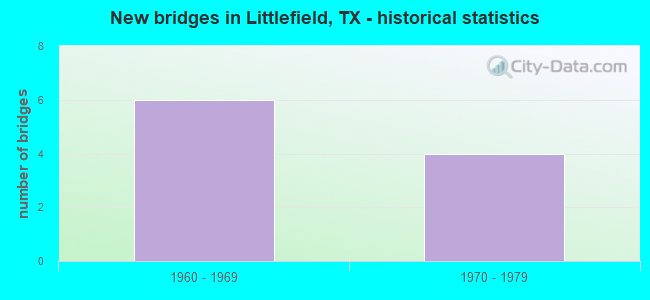
- New bridges - historical statistics
- 61960-1969
- 41970-1979

- Reconstructed bridges - Historical Statistics
- 11980-1989
- 11990-1999


- Bridge Condition - Superstructure
- 75.0%Good
- 25.0%Satisfactory

- Bridge Condition - Substructure
- 50.0%Good
- 25.0%Satisfactory
- 25.0%Fair

- Bridge Condition - Channel
- 50.0%Good
- 50.0%Satisfactory
Find on map >> Show street view
Structure Number: 51400005204019, Location: 2.70 MI NW OF FM 37 (Lat: 34.022017, Lng: -102.463739), Route carried "on" structure: US 84, Year Built: 1967, Year Reconstructed: 1997, Status: Open, Structure Length: 0.85m (2.79ft), Average Daily Traffic: 6,724 (year 2020), Truck Traffic: 18%, Average Future Daily Traffic: 7,990 (year 2033), Design Load: HS 20, Features Intersected: DRAINAGE DITCH
Minimum Vertical Clearance: 30+ m (98+ ft), Kilometerpoint: 19.362, Lanes on structure: 4, Owner: State Highway Agency, Approaching Roadway Width: 24.4m (80.1ft), Material/Design: Concrete, Design/Construction: Culvert, Number Of Spans In Main Unit: 5, Length of Maximum Span: 1.5m (4.9ft), Curb-To-Curb Width: 24.4m (80.1ft), Out-to-Out Width: 41.9m (137.5ft)
Condition: Channel: Good, Culverts: Good, Operating Rating: 39.9 metric tons, Method Used To Determine Operating Rating: Load Factor (LF), Inventory Rating: 23.6 metric tons, Method Used To Determine Inventory Rating: Load Factor (LF), Structural Evaluation: Somewhat better than minimum adequacy, Deck Geometry: Superior to present desirable criteria, Waterway Adequacy: Equal to present minimum criteria, Approach Roadway Alignment: Equal to present desirable criteria, Length Of Structure Improvement: 0.82m (2.69ft), Designated Inspection Frequency: Every 24 months, Inspection Date: July 2021, Bridge Improvement Cost: $2,000, Roadway Improvement Cost: $1,000, Total Project Cost: $3,000, Deck Structure Type: Concrete Cast-file-Place, Wearing Surface/Protective System: Wearing Surface: Bituminous
Find on map >> Show street view
Structure Number: 51400005205016, Location: 0.70 MI N OF FM 54 (Lat: 33.927783, Lng: -102.357492), Route carried "on" structure: US 84, Year Built: 1966, Year Reconstructed: 1986, Status: Open, Structure Length: 0.82m (2.69ft), Average Daily Traffic: 5,570 (year 2013), Truck Traffic: 18%, Average Future Daily Traffic: 7,800 (year 2033), Design Load: HS 20, Features Intersected: DRAINAGE DITCH
Minimum Vertical Clearance: 30+ m (98+ ft), Kilometerpoint: 34.121, Lanes on structure: 2, Owner: State Highway Agency, Approaching Roadway Width: 11.6m (38.1ft), Material/Design: Concrete, Design/Construction: Culvert, Number Of Spans In Main Unit: 4, Length of Maximum Span: 1.8m (5.9ft)
Condition: Channel: Satisfactory, Culverts: Good, Operating Rating: 39.9 metric tons, Method Used To Determine Operating Rating: Load Factor (LF), Inventory Rating: 23.6 metric tons, Method Used To Determine Inventory Rating: Load Factor (LF), Structural Evaluation: Somewhat better than minimum adequacy, Waterway Adequacy: Equal to present minimum criteria, Approach Roadway Alignment: Equal to present desirable criteria, Designated Inspection Frequency: Every 24 months, Inspection Date: July 2021
Find on map >> Show street view
Structure Number: 51400005205017, Location: US 84 @ US 385 (Lat: 33.903886, Lng: -102.327317), Route carried "on" structure: US 84, Year Built: 1966, Status: Open, Structure Length: 5.79m (19.00ft), Average Daily Traffic: 2,876 (year 2019), Truck Traffic: 15%, Average Future Daily Traffic: 5,070 (year 2033), Design Load: H 20, Features Intersected: US 385
Minimum Vertical Clearance: 30+ m (98+ ft), Kilometerpoint: 38.370, Lanes on structure: 2, Lanes under structure: 4, Owner: State Highway Agency, Approaching Roadway Width: 12.2m (40.0ft), Material/Design: Concrete continuous, Design/Construction: Slab, Number Of Spans In Main Unit: 2, Number Of Approach Spans: 2, Length of Maximum Span: 17.4m (57.1ft), Curb-To-Curb Width: 12.0m (39.4ft), Out-to-Out Width: 12.9m (42.3ft)
Condition: Deck: Good, Superstructure: Good, Substructure: Satisfactory, Operating Rating: 49.9 metric tons, Method Used To Determine Operating Rating: Load Factor (LF), Inventory Rating: 29.9 metric tons, Method Used To Determine Inventory Rating: Load Factor (LF), Structural Evaluation: Equal to present minimum criteria, Deck Geometry: Better than present minimum criteria, Underclear: Meets minimum limits, Approach Roadway Alignment: Equal to present desirable criteria, Designated Inspection Frequency: Every 24 months, Inspection Date: July 2021, Deck Structure Type: Concrete Cast-file-Place, Wearing Surface/Protective System: Wearing Surface: Bituminous
Find on map >> Show street view
Structure Number: 51400005205018, Location: US 84 @ US 385 (Lat: 33.903711, Lng: -102.327322), Route carried "on" structure: US 84, Year Built: 1966, Status: Open, Structure Length: 5.73m (18.80ft), Average Daily Traffic: 3,901 (year 2020), Truck Traffic: 15%, Average Future Daily Traffic: 5,070 (year 2033), Design Load: H 20, Features Intersected: US 385
Minimum Vertical Clearance: 30+ m (98+ ft), Kilometerpoint: 38.370, Lanes on structure: 2, Lanes under structure: 4, Owner: State Highway Agency, Approaching Roadway Width: 12.2m (40.0ft), Material/Design: Concrete continuous, Design/Construction: Slab, Number Of Spans In Main Unit: 2, Number Of Approach Spans: 2, Length of Maximum Span: 17.4m (57.1ft), Curb-To-Curb Width: 12.0m (39.4ft), Out-to-Out Width: 12.9m (42.3ft)
Condition: Deck: Good, Superstructure: Good, Substructure: Fair, Operating Rating: 49.9 metric tons, Method Used To Determine Operating Rating: Load Factor (LF), Inventory Rating: 29.9 metric tons, Method Used To Determine Inventory Rating: Load Factor (LF), Structural Evaluation: Somewhat better than minimum adequacy, Deck Geometry: Better than present minimum criteria, Underclear: Meets minimum limits, Approach Roadway Alignment: Equal to present desirable criteria, Length Of Structure Improvement: 5.79m (19.00ft), Designated Inspection Frequency: Every 24 months, Inspection Date: July 2021, Bridge Improvement Cost: $167,000, Roadway Improvement Cost: $42,000, Total Project Cost: $209,000, Deck Structure Type: Concrete Cast-file-Place, Wearing Surface/Protective System: Wearing Surface: Bituminous
Find on map >> Show street view
Structure Number: 51400005205027, Location: US 84 @ FM 54 (Lat: 33.917900, Lng: -102.354842), Route carried "on" structure: US 84, Year Built: 1971, Status: Open, Structure Length: 5.85m (19.19ft), Average Daily Traffic: 3,156 (year 2020), Truck Traffic: 18%, Average Future Daily Traffic: 3,900 (year 2033), Design Load: HS 20, Features Intersected: FM 54
Minimum Vertical Clearance: 30+ m (98+ ft), Kilometerpoint: 35.209, Lanes on structure: 2, Lanes under structure: 4, Owner: State Highway Agency, Approaching Roadway Width: 12.2m (40.0ft), Skew: 1 degrees, Material/Design: Prestressed concrete, Design/Construction: Stringer/Multi-beam, Number Of Spans In Main Unit: 2, Length of Maximum Span: 29.3m (96.1ft), Curb-To-Curb Width: 12.6m (41.3ft), Out-to-Out Width: 13.5m (44.3ft)
Condition: Deck: Good, Superstructure: Satisfactory, Substructure: Good, Operating Rating: 68.0 metric tons, Method Used To Determine Operating Rating: Load Factor (LF), Inventory Rating: 23.6 metric tons, Method Used To Determine Inventory Rating: Load Factor (LF), Structural Evaluation: Equal to present minimum criteria, Deck Geometry: Better than present minimum criteria, Underclear: Equal to present minimum criteria, Approach Roadway Alignment: Equal to present desirable criteria, Designated Inspection Frequency: Every 24 months, Inspection Date: July 2021, Deck Structure Type: Concrete Cast-file-Place, Wearing Surface/Protective System: Wearing Surface: Bituminous
Find on map >> Show street view
Structure Number: 51400005205028, Location: US 84 @ FM 54 (Lat: 33.917894, Lng: -102.355061), Route carried "on" structure: US 84, Year Built: 1971, Status: Open, Structure Length: 5.85m (19.19ft), Average Daily Traffic: 3,156 (year 2020), Truck Traffic: 18%, Average Future Daily Traffic: 3,900 (year 2033), Design Load: HS 20, Features Intersected: FM 54
Minimum Vertical Clearance: 30+ m (98+ ft), Kilometerpoint: 35.216, Lanes on structure: 2, Lanes under structure: 4, Owner: State Highway Agency, Approaching Roadway Width: 11.6m (38.1ft), Skew: 1 degrees, Material/Design: Prestressed concrete, Design/Construction: Stringer/Multi-beam, Number Of Spans In Main Unit: 2, Length of Maximum Span: 29.3m (96.1ft), Curb-To-Curb Width: 12.6m (41.3ft), Out-to-Out Width: 13.5m (44.3ft)
Condition: Deck: Good, Superstructure: Good, Substructure: Good, Operating Rating: 68.0 metric tons, Method Used To Determine Operating Rating: Load Factor (LF), Inventory Rating: 23.6 metric tons, Method Used To Determine Inventory Rating: Load Factor (LF), Structural Evaluation: Equal to present minimum criteria, Deck Geometry: Better than present minimum criteria, Underclear: Equal to present minimum criteria, Approach Roadway Alignment: Equal to present desirable criteria, Designated Inspection Frequency: Every 24 months, Inspection Date: July 2021, Deck Structure Type: Concrete Cast-file-Place, Wearing Surface/Protective System: Wearing Surface: Bituminous
Find on map >> Show street view
Structure Number: 51400005205017, Location: US 84 @ US 385 (Lat: 33.903800, Lng: -101.327300), Route carried "under" structure: US 385, Year Built: 1966, Structure Length: 0. m, Average Daily Traffic: 6,720 (year 2013), Truck Traffic: 23%, Features Intersected: US 385, Facility Carried by Structure: US 84 WB
Minimum Vertical Clearance: 5.08m (16.67ft), Kilometerpoint: 2.203, Lanes on structure: 4, Material/Design: Concrete continuous, Design/Construction: Slab, Length of Maximum Span: 17.4m (57.1ft)
Find on map >> Show street view
Structure Number: 51400005205018, Location: US 84 @ US 385 (Lat: 33.903700, Lng: -102.327300), Route carried "under" structure: US 385, Year Built: 1966, Structure Length: 0. m, Average Daily Traffic: 2,780 (year 2013), Truck Traffic: 13%, Features Intersected: US 385, Facility Carried by Structure: US 84 EB
Minimum Vertical Clearance: 5.03m (16.50ft), Kilometerpoint: 2.235, Lanes on structure: 4, Material/Design: Concrete continuous, Design/Construction: Slab, Length of Maximum Span: 17.4m (57.1ft)
Find on map >> Show street view
Structure Number: 51400005205027, Location: US 84 @ FM 54 (Lat: 33.917900, Lng: -102.354842), Route carried "under" structure: State highway 54, Year Built: 1971, Structure Length: 0. m, Average Daily Traffic: 990 (year 2013), Truck Traffic: 27%, Features Intersected: FM 54, Facility Carried by Structure: US 84 WB
Minimum Vertical Clearance: 4.85m (15.91ft), Kilometerpoint: 24.588, Lanes on structure: 4, Material/Design: Prestressed concrete, Design/Construction: Stringer/Multi-beam, Length of Maximum Span: 29.3m (96.1ft)
Find on map >> Show street view
Structure Number: 51400005205028, Location: US 84 @ FM 54 (Lat: 33.918000, Lng: -102.355000), Route carried "under" structure: State highway 54, Year Built: 1971, Structure Length: 0. m, Average Daily Traffic: 990 (year 2013), Truck Traffic: 27%, Features Intersected: FM 54, Facility Carried by Structure: US 84 EB
Minimum Vertical Clearance: 4.80m (15.75ft), Kilometerpoint: 24.555, Lanes on structure: 4, Material/Design: Prestressed concrete, Design/Construction: Stringer/Multi-beam, Length of Maximum Span: 29.3m (96.1ft)