Bridge Statistics for Lake Station, Indiana (IN)
Condition, Traffic, Stress, Structural Evaluation, Project Costs
- National Bridge Inventory (NBI) Statistics
- 17Number of bridges
- 213ft / 65.2mTotal length
- $137,000Total costs
- 296,373Total average daily traffic
- 70,098Total average daily truck traffic
- National Bridge Inventory (NBI) Registered Bridges for Lake Station
- No street view available for this location
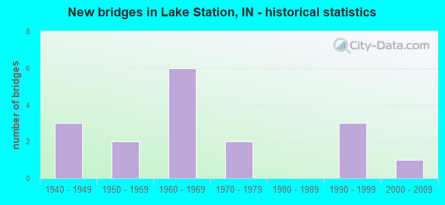
- New bridges - historical statistics
- 31940-1949
- 21950-1959
- 61960-1969
- 21970-1979
- 31990-1999
- 12000-2009
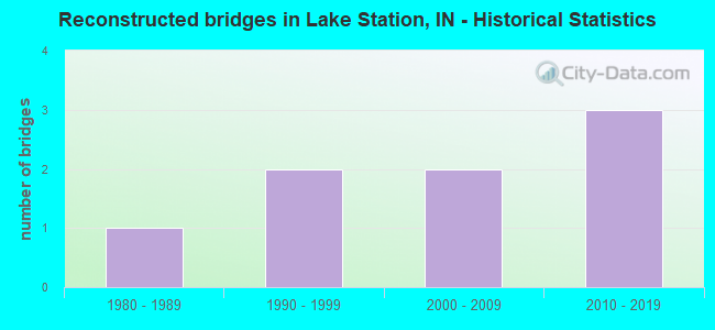
- Reconstructed bridges - Historical Statistics
- 11980-1989
- 21990-1999
- 22000-2009
- 32010-2019
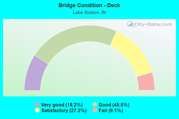
- Bridge Condition - Deck
- 18.2%Very good
- 45.5%Good
- 27.3%Satisfactory
- 9.1%Fair
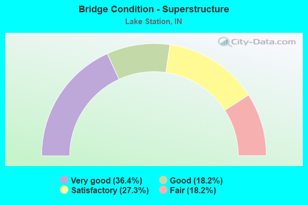
- Bridge Condition - Superstructure
- 36.4%Very good
- 18.2%Good
- 27.3%Satisfactory
- 18.2%Fair
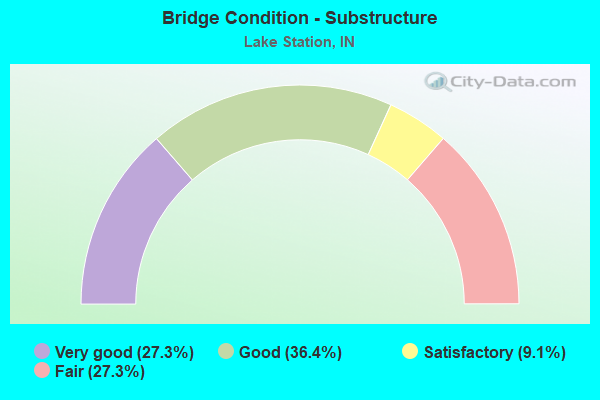
- Bridge Condition - Substructure
- 27.3%Very good
- 36.4%Good
- 9.1%Satisfactory
- 27.3%Fair
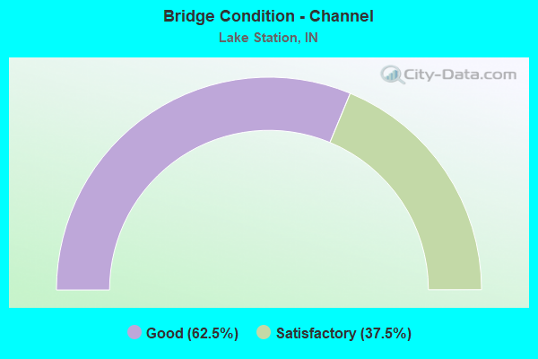
- Bridge Condition - Channel
- 62.5%Good
- 37.5%Satisfactory
Find on map >> Show street view
Structure Number: 49, Location: 00.10 S SR 8 (Lat: 41.356031, Lng: -84.888111), Route carried "on" structure: State highway 1, Year Built: 1990, Status: Open, Structure Length: 2.38m (7.81ft), Average Daily Traffic: 734 (year 2020), Truck Traffic: 8%, Average Future Daily Traffic: 2,270 (year 2032), Design Load: HS 20, Features Intersected: SOL SHANK DITCH
Minimum Vertical Clearance: 30+ m (98+ ft), Kilometerpoint: 12.810, Lanes on structure: 2, Owner: State Highway Agency, Approaching Roadway Width: 12.2m (40.0ft), Material/Design: Prestressed concrete, Design/Construction: Stringer/Multi-beam, Number Of Spans In Main Unit: 1, Length of Maximum Span: 23.2m (76.1ft), Curb-To-Curb Width: 12.2m (40.0ft), Out-to-Out Width: 13.1m (43.0ft)
Condition: Deck: Satisfactory, Superstructure: Very good, Substructure: Good, Channel: Good, Operating Rating: 43.4 metric tons, Method Used To Determine Operating Rating: Load and Resistance Factor Rating (LRFR) rating reported by rating factor(RF) method using HL-93 loadings, Inventory Rating: 28.8 metric tons, Method Used To Determine Inventory Rating: Load and Resistance Factor Rating (LRFR) rating reported by rating factor(RF) method using HL-93 loadings, Structural Evaluation: Better than present minimum criteria, Deck Geometry: Equal to present desirable criteria, Waterway Adequacy: Equal to present desirable criteria, Approach Roadway Alignment: Equal to present desirable criteria, Designated Inspection Frequency: Every 24 months, Inspection Date: October 2021, Deck Structure Type: Concrete Cast-file-Place, Wearing Surface/Protective System: Wearing Surface: Monolithic Concrete, Deck Protection: Epoxy Coated Reinforcing
Find on map >> Show street view
Structure Number: 1886, Location: 00.62 W SR 51 E JCT (Lat: 41.559489, Lng: -87.240950), Route carried "on" structure: US 6, Year Built: 1940, Year Reconstructed: 2008, Status: Open, Structure Length: 7.62m (25.00ft), Average Daily Traffic: 16,223 (year 2004), Truck Traffic: 5%, Average Future Daily Traffic: 25,144 (year 2030), Design Load: HS 20, Features Intersected: DEEP RIVER
Minimum Vertical Clearance: 30+ m (98+ ft), Kilometerpoint: 26.796, Lanes on structure: 2, Base Highway Network: Yes (, Subroute: 1), Owner: State Highway Agency, Approaching Roadway Width: 15.2m (49.9ft), Skew: 5 degrees, Material/Design: Steel continuous, Design/Construction: Stringer/Multi-beam, Number Of Spans In Main Unit: 3, Number Of Approach Spans: 2, Length of Maximum Span: 18.5m (60.7ft), Curb-To-Curb Width: 15.2m (49.9ft), Out-to-Out Width: 16.2m (53.1ft)
Condition: Deck: Very good, Superstructure: Very good, Substructure: Fair, Channel: Good, Operating Rating: 41.1 metric tons, Method Used To Determine Operating Rating: Load and Resistance Factor Rating (LRFR) rating reported by rating factor(RF) method using HL-93 loadings, Inventory Rating: 31.8 metric tons, Method Used To Determine Inventory Rating: Load and Resistance Factor Rating (LRFR) rating reported by rating factor(RF) method using HL-93 loadings, Structural Evaluation: Somewhat better than minimum adequacy, Deck Geometry: Superior to present desirable criteria, Waterway Adequacy: Equal to present desirable criteria, Approach Roadway Alignment: Equal to present desirable criteria, Designated Inspection Frequency: Every 24 months, Underwater Inspection Frequency: Every 60 months, Inspection Date: November 2020, Underwater Inspection Date: September 2021, Deck Structure Type: Concrete Cast-file-Place, Wearing Surface/Protective System: Wearing Surface: Monolithic Concrete, Deck Protection: Epoxy Coated Reinforcing
Find on map >> Show street view
Structure Number: 1887, Location: 00.84 E SR 51/I-80/94 (Lat: 41.570519, Lng: -87.239739), Route carried "on" structure: US 6, Year Built: 1941, Year Reconstructed: 2003, Status: Open, Structure Length: 8.81m (28.90ft), Average Daily Traffic: 16,223 (year 2004), Truck Traffic: 5%, Average Future Daily Traffic: 22,859 (year 2030), Design Load: HS 20, Features Intersected: MUCK POCKET
Minimum Vertical Clearance: 30+ m (98+ ft), Kilometerpoint: 25.492, Lanes on structure: 2, Base Highway Network: Yes (, Subroute: 1), Owner: State Highway Agency, Approaching Roadway Width: 12.2m (40.0ft), Material/Design: Concrete continuous, Design/Construction: Slab, Number Of Spans In Main Unit: 16, Length of Maximum Span: 6.0m (19.7ft), Curb or Sidewalk Widths: Left: 0.0m, Right: 1.5m (4.9ft), Curb-To-Curb Width: 11.9m (39.0ft), Out-to-Out Width: 14.3m (46.9ft)
Condition: Deck: Fair, Superstructure: Fair, Substructure: Fair, Channel: Good, Operating Rating: 53.2 metric tons, Method Used To Determine Operating Rating: Load Factor (LF), Inventory Rating: 31.9 metric tons, Method Used To Determine Inventory Rating: Load Factor (LF), Structural Evaluation: Somewhat better than minimum adequacy, Deck Geometry: Somewhat better than minimum adequacy, Waterway Adequacy: Better than present minimum criteria, Approach Roadway Alignment: Equal to present desirable criteria, Designated Inspection Frequency: Every 24 months, Inspection Date: November 2020, Deck Structure Type: Concrete Cast-file-Place, Wearing Surface/Protective System: Wearing Surface: Latex Concrete, Deck Protection: Epoxy Coated Reinforcing
Find on map >> Show street view
Structure Number: 1888, Location: 00.71 E SR 51/I-80/94 (Lat: 41.572939, Lng: -87.239831), Route carried "on" structure: US 6, Year Built: 1941, Year Reconstructed: 2003, Status: Open, Structure Length: 5.40m (17.72ft), Average Daily Traffic: 16,223 (year 2004), Truck Traffic: 5%, Average Future Daily Traffic: 22,859 (year 2030), Design Load: HS 20, Features Intersected: DEEP RIVER
Minimum Vertical Clearance: 30+ m (98+ ft), Kilometerpoint: 25.283, Lanes on structure: 2, Base Highway Network: Yes (, Subroute: 1), Owner: State Highway Agency, Approaching Roadway Width: 11.6m (38.1ft), Material/Design: Steel continuous, Design/Construction: Stringer/Multi-beam, Number Of Spans In Main Unit: 4, Length of Maximum Span: 14.6m (47.9ft), Curb or Sidewalk Widths: Left: 0.0m, Right: 1.5m (4.9ft), Curb-To-Curb Width: 11.7m (38.4ft), Out-to-Out Width: 14.0m (45.9ft)
Condition: Deck: Good, Superstructure: Good, Substructure: Good, Channel: Good, Operating Rating: 37.9 metric tons, Method Used To Determine Operating Rating: Load and Resistance Factor Rating (LRFR) rating reported by rating factor(RF) method using HL-93 loadings, Inventory Rating: 29.2 metric tons, Method Used To Determine Inventory Rating: Load and Resistance Factor Rating (LRFR) rating reported by rating factor(RF) method using HL-93 loadings, Structural Evaluation: Better than present minimum criteria, Deck Geometry: Somewhat better than minimum adequacy, Waterway Adequacy: Equal to present desirable criteria, Approach Roadway Alignment: Equal to present desirable criteria, Designated Inspection Frequency: Every 24 months, Underwater Inspection Frequency: Every 60 months, Inspection Date: November 2020, Underwater Inspection Date: September 2021, Deck Structure Type: Concrete Cast-file-Place, Wearing Surface/Protective System: Wearing Surface: Latex Concrete, Deck Protection: Epoxy Coated Reinforcing
Find on map >> Show street view
Structure Number: 4666, Location: 00.24 W SR 51 (Lat: 41.592250, Lng: -87.248628), Route carried "on" structure: Interstate 90, Year Built: 1956, Year Reconstructed: 1986, Status: Open, Structure Length: 5.36m (17.59ft), Average Daily Traffic: 24,234 (year 2004), Truck Traffic: 5%, Average Future Daily Traffic: 55,964 (year 2031), Design Load: HS 20, Features Intersected: HOBART ROAD
Minimum Vertical Clearance: 30+ m (98+ ft), Kilometerpoint: 32.155, Lanes on structure: 2, Lanes under structure: 2, Base Highway Network: Yes (, Subroute: 1), Toll: On toll road, Owner: State Toll Authority, Approaching Roadway Width: 17.4m (57.1ft), Skew: 2 degrees, Material/Design: Steel, Design/Construction: Stringer/Multi-beam, Number Of Spans In Main Unit: 3, Length of Maximum Span: 19.2m (63.0ft), Curb-To-Curb Width: 17.4m (57.1ft), Out-to-Out Width: 18.3m (60.0ft)
Condition: Deck: Very good, Superstructure: Very good, Substructure: Very good, Operating Rating: 43.7 metric tons, Method Used To Determine Operating Rating: Load and Resistance Factor Rating (LRFR) rating reported by rating factor(RF) method using HL-93 loadings, Inventory Rating: 33.7 metric tons, Method Used To Determine Inventory Rating: Load and Resistance Factor Rating (LRFR) rating reported by rating factor(RF) method using HL-93 loadings, Structural Evaluation: Equal to present desirable criteria, Deck Geometry: Superior to present desirable criteria, Underclear: Equal to present minimum criteria, Approach Roadway Alignment: Equal to present minimum criteria, Designated Inspection Frequency: Every 24 months, Other Special Inspection Frequency: Every 24 months, Inspection Date: July 2021, Other Special Inspection Date: July 2021, Deck Structure Type: Concrete Cast-file-Place, Wearing Surface/Protective System: Wearing Surface: Latex Concrete, Deck Protection: Epoxy Coated Reinforcing
Find on map >> Show street view
Structure Number: 49, Location: 00.46 E I-80 (Lat: 41.590089, Lng: -87.223811), Route carried "on" structure: Interstate 94, Year Built: 1966, Year Reconstructed: 2017, Status: Open, Structure Length: 7.35m (24.11ft), Average Daily Traffic: 36,533 (year 2020), Truck Traffic: 32%, Average Future Daily Traffic: 60,890 (year 2038), Design Load: HS 20+Mod, Features Intersected: I-90 EB/WB
Minimum Vertical Clearance: 30+ m (98+ ft), Kilometerpoint: 25.701, Lanes on structure: 3, Lanes under structure: 4, Base Highway Network: Yes (, Subroute: 1), Owner: State Highway Agency, Approaching Roadway Width: 20.0m (65.6ft), Skew: 2 degrees, Material/Design: Steel continuous, Design/Construction: Stringer/Multi-beam, Number Of Spans In Main Unit: 4, Length of Maximum Span: 22.9m (75.1ft), Curb-To-Curb Width: 19.6m (64.3ft), Out-to-Out Width: 20.5m (67.3ft)
Condition: Deck: Good, Superstructure: Satisfactory, Substructure: Very good, Operating Rating: 62.9 metric tons, Method Used To Determine Operating Rating: Load Factor (LF), Inventory Rating: 37.7 metric tons, Method Used To Determine Inventory Rating: Load Factor (LF), Structural Evaluation: Equal to present minimum criteria, Deck Geometry: Superior to present desirable criteria, Underclear: Meets minimum limits, Approach Roadway Alignment: Equal to present desirable criteria, Designated Inspection Frequency: Every 24 months, Other Special Inspection Frequency: Every 48 months, Inspection Date: March 2022, Other Special Inspection Date: August 2018, Deck Structure Type: Concrete Cast-file-Place, Wearing Surface/Protective System: Wearing Surface: Monolithic Concrete, Deck Protection: Epoxy Coated Reinforcing
Find on map >> Show street view
Structure Number: 4901, Location: 00.46 E I-80 (Lat: 41.590150, Lng: -87.223989), Route carried "on" structure: Interstate 94, Year Built: 1966, Year Reconstructed: 2017, Status: Open, Structure Length: 7.35m (24.11ft), Average Daily Traffic: 42,223 (year 2021), Truck Traffic: 32%, Average Future Daily Traffic: 60,890 (year 2038), Design Load: HS 20+Mod, Features Intersected: I-90 EB/WB
Minimum Vertical Clearance: 30+ m (98+ ft), Kilometerpoint: 25.701, Lanes on structure: 3, Lanes under structure: 4, Base Highway Network: Yes (, Subroute: 1), Owner: State Highway Agency, Approaching Roadway Width: 20.0m (65.6ft), Skew: 2 degrees, Material/Design: Steel continuous, Design/Construction: Stringer/Multi-beam, Number Of Spans In Main Unit: 4, Length of Maximum Span: 22.9m (75.1ft), Curb-To-Curb Width: 19.6m (64.3ft), Out-to-Out Width: 20.5m (67.3ft)
Condition: Deck: Good, Superstructure: Good, Substructure: Very good, Operating Rating: 62.9 metric tons, Method Used To Determine Operating Rating: Load Factor (LF), Inventory Rating: 37.7 metric tons, Method Used To Determine Inventory Rating: Load Factor (LF), Structural Evaluation: Better than present minimum criteria, Deck Geometry: Superior to present desirable criteria, Underclear: Somewhat better than minimum adequacy, Approach Roadway Alignment: Equal to present desirable criteria, Designated Inspection Frequency: Every 24 months, Other Special Inspection Frequency: Every 48 months, Inspection Date: March 2022, Other Special Inspection Date: August 2018, Deck Structure Type: Concrete Cast-file-Place, Wearing Surface/Protective System: Wearing Surface: Monolithic Concrete
Find on map >> Show street view
Structure Number: 450012, Location: 00.80 N. of RIDGE RD (Lat: 41.560519, Lng: -87.408250), Route carried "on" structure: City street , Year Built: 1978, Year Reconstructed: 2014, Status: Posted for load, Structure Length: 5.08m (16.67ft), Average Daily Traffic: 3,518 (year 2012), Truck Traffic: 5%, Average Future Daily Traffic: 4,557 (year 2038), Features Intersected: LITTLE CALUMET RIVER, Facility Carried by Structure: CALHOUN STREET
Minimum Vertical Clearance: 30+ m (98+ ft), Kilometerpoint: 0.000, Lanes on structure: 2, Owner: County Highway Agency, Approaching Roadway Width: 7.3m (24.0ft), Navigation Control: Yes ( Vertical Clearance: 3.0m (9.8ft), Horizontal Clearance: 15.2m (49.9ft)), Material/Design: Prestressed concrete, Design/Construction: Box Beam or Girders - Multiple, Number Of Spans In Main Unit: 3, Length of Maximum Span: 16.8m (55.1ft), Curb or Sidewalk Widths: Left: 1.8m (5.9ft), Right: 1.8m (5.9ft), Curb-To-Curb Width: 8.6m (28.2ft), Out-to-Out Width: 12.3m (40.4ft)
Condition: Deck: Good, Superstructure: Fair, Substructure: Fair, Channel: Satisfactory, Operating Rating: 26.7 metric tons, Method Used To Determine Operating Rating: Load Factor (LF), Inventory Rating: 16.0 metric tons, Method Used To Determine Inventory Rating: Load Factor (LF), Structural Evaluation: Meets minimum limits, Deck Geometry: Meets minimum limits, Waterway Adequacy: Better than present minimum criteria, Approach Roadway Alignment: Equal to present desirable criteria, Bridge Posting: Required (Relationship of Operating Rating to Maximum Legal Load: 10.0 - 19.9% below), Designated Inspection Frequency: Every 24 months, Inspection Date: August 2020, Deck Structure Type: Concrete Cast-file-Place, Wearing Surface/Protective System: Wearing Surface: Monolithic Concrete
Find on map >> Show street view
Structure Number: 4500125, Location: 00.40 N. of CENTRAL (Lat: 41.576819, Lng: -87.278689), Route carried "on" structure: City street , Year Built: 1997, Status: Open, Structure Length: 4.23m (13.88ft), Average Daily Traffic: 2,849 (year 2018), Truck Traffic: 2%, Average Future Daily Traffic: 3,512 (year 2038), Design Load: HS 20, Features Intersected: BURNS DITCH, Facility Carried by Structure: CLAY STREET
Minimum Vertical Clearance: 30+ m (98+ ft), Kilometerpoint: 0.000, Lanes on structure: 2, Owner: County Highway Agency, Approaching Roadway Width: 7.0m (23.0ft), Material/Design: Prestressed concrete continuous, Design/Construction: Stringer/Multi-beam, Number Of Spans In Main Unit: 3, Length of Maximum Span: 17.9m (58.7ft), Curb-To-Curb Width: 10.8m (35.4ft), Out-to-Out Width: 11.7m (38.4ft)
Condition: Deck: Good, Superstructure: Very good, Substructure: Good, Channel: Satisfactory, Operating Rating: 54.5 metric tons, Method Used To Determine Operating Rating: Field evaluation and documented engineering judgment, Inventory Rating: 32.7 metric tons, Method Used To Determine Inventory Rating: Field evaluation and documented engineering judgment, Structural Evaluation: Better than present minimum criteria, Deck Geometry: Somewhat better than minimum adequacy, Waterway Adequacy: Superior to present desirable criteria, Approach Roadway Alignment: Equal to present desirable criteria, Designated Inspection Frequency: Every 24 months, Inspection Date: August 2020, Deck Structure Type: Concrete Precast Panels, Wearing Surface/Protective System: Wearing Surface: Monolithic Concrete, Deck Protection: Epoxy Coated Reinforcing
Find on map >> Show street view
Structure Number: 4500127, Location: 00.40 W. of STATE ST (Lat: 41.562831, Lng: -87.290869), Route carried "on" structure: City street , Year Built: 1991, Status: Open, Structure Length: 3.69m (12.11ft), Average Daily Traffic: 2,143 (year 2018), Truck Traffic: 3%, Average Future Daily Traffic: 2,615 (year 2038), Design Load: HS 20, Features Intersected: DEEP RIVER, Facility Carried by Structure: LIVERPOOL ROAD
Minimum Vertical Clearance: 30+ m (98+ ft), Kilometerpoint: 0.000, Lanes on structure: 2, Owner: County Highway Agency, Approaching Roadway Width: 6.7m (22.0ft), Material/Design: Concrete continuous, Design/Construction: Slab, Number Of Spans In Main Unit: 3, Length of Maximum Span: 14.1m (46.3ft), Curb or Sidewalk Widths: Left: 1.2m (3.9ft), Right: 1.2m (3.9ft), Curb-To-Curb Width: 15.9m (52.2ft), Out-to-Out Width: 19.2m (63.0ft)
Condition: Deck: Satisfactory, Superstructure: Satisfactory, Substructure: Good, Channel: Satisfactory, Operating Rating: 54.5 metric tons, Method Used To Determine Operating Rating: Field evaluation and documented engineering judgment, Inventory Rating: 32.7 metric tons, Method Used To Determine Inventory Rating: Field evaluation and documented engineering judgment, Structural Evaluation: Equal to present minimum criteria, Deck Geometry: Superior to present desirable criteria, Waterway Adequacy: Equal to present desirable criteria, Approach Roadway Alignment: Equal to present desirable criteria, Length Of Structure Improvement: 3.69m (12.11ft), Designated Inspection Frequency: Every 24 months, Inspection Date: August 2020, Bridge Improvement Cost: $104,000, Roadway Improvement Cost: $33,000, Total Project Cost: $137,000 ( Estimate for 2018), Deck Structure Type: Concrete Cast-file-Place, Wearing Surface/Protective System: Wearing Surface: Monolithic Concrete
Find on map >> Show street view
Structure Number: 4500129, Location: 00.40 S. of CENTRAL AVE (Lat: 41.564919, Lng: -87.260381), Route carried "on" structure: City street , Year Built: 1975, Year Reconstructed: 2010, Status: Open, Structure Length: 7.92m (25.98ft), Average Daily Traffic: 3,862 (year 2018), Truck Traffic: 3%, Average Future Daily Traffic: 4,713 (year 2038), Design Load: HS 20, Features Intersected: DEEP RIVER, Facility Carried by Structure: GRAND BLVD.
Minimum Vertical Clearance: 30+ m (98+ ft), Kilometerpoint: 0.000, Lanes on structure: 2, Owner: County Highway Agency, Approaching Roadway Width: 8.0m (26.2ft), Skew: 3 degrees, Material/Design: Prestressed concrete continuous, Design/Construction: Stringer/Multi-beam, Number Of Spans In Main Unit: 3, Length of Maximum Span: 26.4m (86.6ft), Curb or Sidewalk Widths: Left: 1.5m (4.9ft), Right: 1.5m (4.9ft), Curb-To-Curb Width: 9.1m (29.9ft), Out-to-Out Width: 13.0m (42.7ft)
Condition: Deck: Satisfactory, Superstructure: Satisfactory, Substructure: Satisfactory, Channel: Good, Operating Rating: 55.4 metric tons, Method Used To Determine Operating Rating: Load Factor (LF), Inventory Rating: 33.2 metric tons, Method Used To Determine Inventory Rating: Load Factor (LF), Structural Evaluation: Equal to present minimum criteria, Deck Geometry: Meets minimum limits, Waterway Adequacy: Superior to present desirable criteria, Approach Roadway Alignment: Equal to present desirable criteria, Designated Inspection Frequency: Every 24 months, Inspection Date: August 2020, Deck Structure Type: Concrete Cast-file-Place, Wearing Surface/Protective System: Wearing Surface: Monolithic Concrete
Find on map >> Show street view
Structure Number: 4666, Location: 00.24 W SR 51 (Lat: 41.592250, Lng: -87.248628), Route carried "under" structure: City street , Year Built: 1956, Structure Length: 0. m, Average Daily Traffic: 5,568 (year 2014), Truck Traffic: 5%, Features Intersected: HOBART RD, Facility Carried by Structure: I-90 WB
Minimum Vertical Clearance: 4.50m (14.76ft), Kilometerpoint: 0.000, Lanes on structure: 2, Lanes under structure: 2, Material/Design: Steel, Design/Construction: Stringer/Multi-beam, Length of Maximum Span: 19.2m (63.0ft)
Find on map >> Show street view
Structure Number: 49, Location: 00.46 E I-80 (Lat: 41.590089, Lng: -87.223817), Route carried "under" structure: Interstate 90, Year Built: 1966, Structure Length: 0. m, Average Daily Traffic: 20,500 (year 2004), Truck Traffic: 20%, Features Intersected: I-90 WBL, Facility Carried by Structure: I-94 EB
Minimum Vertical Clearance: 4.79m (15.72ft), Kilometerpoint: 34.295, Lanes on structure: 3, Lanes under structure: 2, Material/Design: Steel continuous, Design/Construction: Stringer/Multi-beam, Length of Maximum Span: 22.9m (75.1ft)
Find on map >> Show street view
Structure Number: 49, Location: 00.46 E I-80 (Lat: 41.590089, Lng: -87.223817), Route carried "under" structure: Interstate 90, Year Built: 1966, Structure Length: 0. m, Average Daily Traffic: 20,500 (year 2004), Truck Traffic: 20%, Features Intersected: I-90 EBL, Facility Carried by Structure: I-94 EB
Minimum Vertical Clearance: 4.82m (15.81ft), Kilometerpoint: 34.295, Lanes on structure: 3, Lanes under structure: 2, Material/Design: Steel continuous, Design/Construction: Stringer/Multi-beam, Length of Maximum Span: 22.9m (75.1ft)
Find on map >> Show street view
Structure Number: 4901, Location: 00.46 E I-80 (Lat: 41.590150, Lng: -87.224000), Route carried "under" structure: Interstate 90, Year Built: 1966, Structure Length: 0. m, Average Daily Traffic: 16,570 (year 2021), Truck Traffic: 47%, Features Intersected: I-90 EBL, Facility Carried by Structure: I-94 WB
Minimum Vertical Clearance: 4.88m (16.01ft), Kilometerpoint: 34.279, Lanes on structure: 3, Lanes under structure: 2, Material/Design: Steel continuous, Design/Construction: Stringer/Multi-beam, Length of Maximum Span: 22.9m (75.1ft)
Find on map >> Show street view
Structure Number: 4901, Location: 00.46 E I-80 (Lat: 41.590150, Lng: -87.224000), Route carried "under" structure: Interstate 90, Year Built: 1966, Structure Length: 0. m, Average Daily Traffic: 17,400 (year 2021), Truck Traffic: 47%, Features Intersected: I-90 WBL, Facility Carried by Structure: I-94 WB
Minimum Vertical Clearance: 4.88m (16.01ft), Kilometerpoint: 34.279, Lanes on structure: 3, Lanes under structure: 2, Material/Design: Steel continuous, Design/Construction: Stringer/Multi-beam, Length of Maximum Span: 22.9m (75.1ft)
Find on map >> Show street view
Structure Number: 76506, Location: 00.22 E I-65 (Lat: 41.570019, Lng: -87.296411), Route carried "under" structure: Interstate 80, Year Built: 2009, Structure Length: 0. m, Average Daily Traffic: 51,070 (year 2006), Truck Traffic: 32%, Features Intersected: I-80 EBL MAINLINE, Facility Carried by Structure: COLORADO STREET
Minimum Vertical Clearance: 5.03m (16.50ft), Kilometerpoint: 19.264, Lanes on structure: 2, Lanes under structure: 13, Material/Design: Steel continuous, Design/Construction: Stringer/Multi-beam, Length of Maximum Span: 48.8m (160.1ft)