Bridge Statistics for Fredonia, New York (NY)
Condition, Traffic, Stress, Structural Evaluation, Project Costs
- National Bridge Inventory (NBI) Statistics
- 15Number of bridges
- 177ft / 54.5mTotal length
- $42,113,000Total costs
- 73,936Total average daily traffic
- 2,139Total average daily truck traffic
- National Bridge Inventory (NBI) Registered Bridges for Fredonia
- No street view available for this location
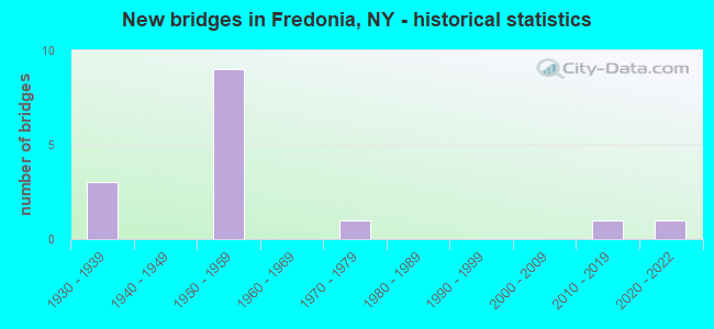
- New bridges - historical statistics
- 31930-1939
- 91950-1959
- 11970-1979
- 12010-2019
- 12020-2022

- Reconstructed bridges - Historical Statistics
- 11960-1969
- 01970-1979
- 11980-1989
- 01990-1999
- 02000-2009
- 32010-2019


- Bridge Condition - Deck
- 9.1%Excellent
- 36.4%Very good
- 18.2%Satisfactory
- 27.3%Fair
- 9.1%Poor

- Bridge Condition - Superstructure
- 9.1%Excellent
- 18.2%Very good
- 9.1%Good
- 27.3%Satisfactory
- 36.4%Fair

- Bridge Condition - Substructure
- 18.2%Very good
- 27.3%Good
- 36.4%Satisfactory
- 18.2%Fair

- Bridge Condition - Channel
- 28.6%Very good
- 28.6%Good
- 14.3%Satisfactory
- 28.6%Fair
Find on map >> Show street view
Structure Number: 10154, Location: 1.6 MI SW JCT RTS 20 + 60 (Lat: 42.437744, Lng: -79.333692), Route carried "on" structure: US 20, Year Built: 1936, Year Reconstructed: 1994, Status: Open, Structure Length: 2.10m (6.89ft), Average Daily Traffic: 4,027 (year 2018), Truck Traffic: 7%, Average Future Daily Traffic: 4,045 (year 2040), Design Load: HS 20, Features Intersected: CANADAWAY CREEK
Minimum Vertical Clearance: 30+ m (98+ ft), Kilometerpoint: 41.802, Lanes on structure: 2, Base Highway Network: Yes, Owner: State Highway Agency, Approaching Roadway Width: 12.8m (42.0ft), Skew: 20 degrees, Material/Design: Steel, Design/Construction: Girder and Floorbeam System, Number Of Spans In Main Unit: 1, Length of Maximum Span: 20.4m (66.9ft), Curb or Sidewalk Widths: Left: 2.3m (7.5ft), Right: 2.3m (7.5ft), Curb-To-Curb Width: 12.6m (41.3ft), Out-to-Out Width: 17.7m (58.1ft)
Condition: Deck: Very good, Superstructure: Satisfactory, Substructure: Good, Channel: Good, Operating Rating: 49.0 metric tons, Method Used To Determine Operating Rating: Allowable Stress (AS), Inventory Rating: 28.1 metric tons, Method Used To Determine Inventory Rating: Allowable Stress (AS), Structural Evaluation: Equal to present minimum criteria, Deck Geometry: Equal to present minimum criteria, Waterway Adequacy: Meets minimum limits, Approach Roadway Alignment: Equal to present desirable criteria, Length Of Structure Improvement: 2.10m (6.89ft), Designated Inspection Frequency: Every 24 months, Critical Feature Inspection Frequency: Every 24 months, Inspection Date: April 2021, Critical Feature Inspection Date: April 2021, Bridge Improvement Cost: $2,271,000, Roadway Improvement Cost: $1,330,000, Total Project Cost: $3,600,000 ( Estimate for 2021), Deck Structure Type: Concrete Cast-file-Place, Wearing Surface/Protective System: Wearing Surface: Integral Concrete, Deck Protection: Epoxy Coated Reinforcing
Find on map >> Show street view
Structure Number: 102789, Location: 0.8 MI NW JCT RTS 20 & 60 (Lat: 42.461256, Lng: -79.313789), Route carried "on" structure: State highway 60, Year Built: 1957, Year Reconstructed: 2019, Status: Open, Structure Length: 8.38m (27.49ft), Average Daily Traffic: 10,200 (year 2020), Truck Traffic: 9%, Average Future Daily Traffic: 10,247 (year 2040), Features Intersected: 90IX EB, RTE I90
Minimum Vertical Clearance: 30+ m (98+ ft), Kilometerpoint: 50.088, Lanes on structure: 3, Lanes under structure: 4, Base Highway Network: Yes, Owner: State Highway Agency, Approaching Roadway Width: 21.9m (71.9ft), Skew: 1 degrees, Material/Design: Steel, Design/Construction: Stringer/Multi-beam, Number Of Spans In Main Unit: 5, Length of Maximum Span: 18.8m (61.7ft), Curb-To-Curb Width: 17.1m (56.1ft), Out-to-Out Width: 18.7m (61.4ft)
Condition: Deck: Very good, Superstructure: Good, Substructure: Satisfactory, Operating Rating: 59.9 metric tons, Method Used To Determine Operating Rating: Load Factor (LF), Inventory Rating: 41.7 metric tons, Method Used To Determine Inventory Rating: Load Factor (LF), Structural Evaluation: Equal to present minimum criteria, Deck Geometry: Superior to present desirable criteria, Underclear: High priority of corrective action, Approach Roadway Alignment: Equal to present minimum criteria, Length Of Structure Improvement: 8.38m (27.49ft), Designated Inspection Frequency: Every 24 months, Inspection Date: August 2021, Bridge Improvement Cost: $5,639,000, Roadway Improvement Cost: $3,302,000, Total Project Cost: $8,941,000 ( Estimate for 2021), Deck Structure Type: Concrete Cast-file-Place, Wearing Surface/Protective System: Wearing Surface: Bituminous, Membrane: Other
Find on map >> Show street view
Structure Number: 105059, Location: 1.5 MI NW JCT SH60 & SH83 (Lat: 42.432242, Lng: -79.314453), Route carried "on" structure: County highway , Year Built: 1930, Year Reconstructed: 1973, Status: Open, Structure Length: 2.83m (9.28ft), Average Daily Traffic: 798 (year 2018), Truck Traffic: 6%, Average Future Daily Traffic: 987 (year 2040), Design Load: HS 20, Features Intersected: CANADAWAY CREEK, Facility Carried by Structure: LIBERTY STREET
Minimum Vertical Clearance: 30+ m (98+ ft), Kilometerpoint: 1.979, Lanes on structure: 2, Owner: County Highway Agency, Approaching Roadway Width: 7.3m (24.0ft), Skew: 2 degrees, Material/Design: Concrete, Design/Construction: Tee Beam, Number Of Spans In Main Unit: 2, Length of Maximum Span: 12.8m (42.0ft), Curb or Sidewalk Widths: Left: 1.6m (5.2ft), Right: 0.0m, Curb-To-Curb Width: 9.2m (30.2ft), Out-to-Out Width: 11.6m (38.1ft)
Condition: Deck: Satisfactory, Superstructure: Satisfactory, Substructure: Fair, Channel: Fair, Operating Rating: 39.9 metric tons, Method Used To Determine Operating Rating: Load Factor (LF), Inventory Rating: 23.6 metric tons, Method Used To Determine Inventory Rating: Load Factor (LF), Structural Evaluation: Somewhat better than minimum adequacy, Deck Geometry: Equal to present minimum criteria, Waterway Adequacy: Meets minimum limits, Approach Roadway Alignment: Meets minimum limits, Length Of Structure Improvement: 2.83m (9.28ft), Designated Inspection Frequency: Every 24 months, Inspection Date: April 2021, Bridge Improvement Cost: $1,162,000, Roadway Improvement Cost: $680,000, Total Project Cost: $1,842,000 ( Estimate for 2021), Deck Structure Type: Concrete Cast-file-Place, Wearing Surface/Protective System: Wearing Surface: Bituminous
Find on map >> Show street view
Structure Number: 10506, Location: 2.3 MI NW JCT RTS 83 + 60 (Lat: 42.438428, Lng: -79.329842), Route carried "on" structure: Spur County highway , Year Built: 1973, Status: Open, Structure Length: 2.35m (7.71ft), Average Daily Traffic: 4,320 (year 2020), Truck Traffic: 5%, Average Future Daily Traffic: 4,561 (year 2040), Design Load: HS 20, Features Intersected: CANADAWAY CREEK, Facility Carried by Structure: WATER STREET
Minimum Vertical Clearance: 30+ m (98+ ft), Kilometerpoint: 3.459, Lanes on structure: 2, Owner: County Highway Agency, Approaching Roadway Width: 9.1m (29.9ft), Skew: 2 degrees, Material/Design: Prestressed concrete continuous, Design/Construction: Box Beam or Girders - Multiple, Number Of Spans In Main Unit: 2, Length of Maximum Span: 11.2m (36.7ft), Curb or Sidewalk Widths: Left: 1.5m (4.9ft), Right: 1.5m (4.9ft), Curb-To-Curb Width: 9.1m (29.9ft), Out-to-Out Width: 13.0m (42.7ft)
Condition: Deck: Fair, Superstructure: Fair, Substructure: Satisfactory, Channel: Satisfactory, Operating Rating: 42.6 metric tons, Method Used To Determine Operating Rating: Load Factor (LF), Inventory Rating: 18.1 metric tons, Method Used To Determine Inventory Rating: Load Factor (LF), Structural Evaluation: Somewhat better than minimum adequacy, Deck Geometry: Meets minimum limits, Waterway Adequacy: Meets minimum limits, Approach Roadway Alignment: Better than present minimum criteria, Length Of Structure Improvement: 2.34m (7.68ft), Designated Inspection Frequency: Every 24 months, Inspection Date: April 2021, Bridge Improvement Cost: $1,134,000, Roadway Improvement Cost: $664,000, Total Project Cost: $1,799,000 ( Estimate for 2021), Wearing Surface/Protective System: Wearing Surface: Bituminous
Find on map >> Show street view
Structure Number: 221239, Location: 0.8 MI SW OF DUNKIRK (Lat: 42.460667, Lng: -79.364942), Route carried "on" structure: Other road , Year Built: 1950, Year Reconstructed: 2010, Status: Open, Structure Length: 1.07m (3.51ft), Average Daily Traffic: 839 (year 2020), Truck Traffic: 5%, Average Future Daily Traffic: 1,038 (year 2040), Design Load: HS 25 or greater, Features Intersected: BEAVER CREEK, Facility Carried by Structure: CHESTNUT ROAD
Minimum Vertical Clearance: 30+ m (98+ ft), Kilometerpoint: 0.451, Lanes on structure: 2, Owner: County Highway Agency, Approaching Roadway Width: 6.1m (20.0ft), Skew: 4 degrees, Material/Design: Prestressed concrete, Design/Construction: Box Beam or Girders - Multiple, Number Of Spans In Main Unit: 1, Length of Maximum Span: 10.1m (33.1ft), Curb-To-Curb Width: 8.5m (27.9ft), Out-to-Out Width: 9.2m (30.2ft)
Condition: Deck: Very good, Superstructure: Very good, Substructure: Very good, Channel: Very good, Operating Rating: 69.0 metric tons, Method Used To Determine Operating Rating: Load and Resistance Factor Rating (LRFR) rating reported by rating factor(RF) method using HL-93 loadings, Inventory Rating: 53.5 metric tons, Method Used To Determine Inventory Rating: Load and Resistance Factor Rating (LRFR) rating reported by rating factor(RF) method using HL-93 loadings, Structural Evaluation: Equal to present desirable criteria, Deck Geometry: Somewhat better than minimum adequacy, Waterway Adequacy: Equal to present minimum criteria, Approach Roadway Alignment: Equal to present desirable criteria, Length Of Structure Improvement: 1.06m (3.48ft), Designated Inspection Frequency: Every 24 months, Inspection Date: December 2020, Bridge Improvement Cost: $451,000, Roadway Improvement Cost: $264,000, Total Project Cost: $715,000 ( Estimate for 2021), Wearing Surface/Protective System: Wearing Surface: Bituminous, Membrane: Other
Find on map >> Show street view
Structure Number: 332424, Location: 0.6 MI SW OF CITY DUNKIRK (Lat: 42.462439, Lng: -79.364081), Route carried "on" structure: County highway , Year Built: 1931, Status: Open, Structure Length: 2.10m (6.89ft), Average Daily Traffic: 1,021 (year 2017), Truck Traffic: 2%, Average Future Daily Traffic: 1,429 (year 2037), Features Intersected: CANADAWAY CREEK, Facility Carried by Structure: WEST WILLOW ROAD
Minimum Vertical Clearance: 30+ m (98+ ft), Kilometerpoint: 0.547, Lanes on structure: 2, Owner: County Highway Agency, Approaching Roadway Width: 6.7m (22.0ft), Material/Design: Steel, Design/Construction: Stringer/Multi-beam, Number Of Spans In Main Unit: 1, Length of Maximum Span: 20.4m (66.9ft), Curb-To-Curb Width: 7.3m (24.0ft), Out-to-Out Width: 8.2m (26.9ft)
Condition: Deck: Fair, Superstructure: Fair, Substructure: Fair, Channel: Fair, Operating Rating: 71.7 metric tons, Method Used To Determine Operating Rating: Load Factor (LF), Inventory Rating: 42.6 metric tons, Method Used To Determine Inventory Rating: Load Factor (LF), Structural Evaluation: Somewhat better than minimum adequacy, Deck Geometry: Meets minimum limits, Waterway Adequacy: Meets minimum limits, Approach Roadway Alignment: Meets minimum limits, Length Of Structure Improvement: 2.10m (6.89ft), Designated Inspection Frequency: Every 24 months, Inspection Date: April 2021, Bridge Improvement Cost: $912,000, Roadway Improvement Cost: $534,000, Total Project Cost: $1,446,000 ( Estimate for 2021), Deck Structure Type: Concrete Cast-file-Place, Wearing Surface/Protective System: Wearing Surface: Bituminous
Find on map >> Show street view
Structure Number: 332608, Location: AT FREDONIA (Lat: 42.450478, Lng: -79.350547), Route carried "on" structure: County highway , Year Built: 2020, Status: Open, Structure Length: 2.93m (9.61ft), Average Daily Traffic: 2,194 (year 2016), Truck Traffic: 4%, Average Future Daily Traffic: 2,714 (year 2040), Features Intersected: CANADAWAY CREEK, Facility Carried by Structure: MATTESON STREET
Minimum Vertical Clearance: 30+ m (98+ ft), Kilometerpoint: 5.213, Lanes on structure: 2, Owner: County Highway Agency, Approaching Roadway Width: 7.9m (25.9ft), Material/Design: Steel, Design/Construction: Stringer/Multi-beam, Number Of Spans In Main Unit: 1, Length of Maximum Span: 27.4m (89.9ft), Curb-To-Curb Width: 9.8m (32.2ft), Out-to-Out Width: 10.8m (35.4ft)
Condition: Deck: Excellent, Superstructure: Excellent, Substructure: Very good, Channel: Good, Operating Rating: 43.7 metric tons, Method Used To Determine Operating Rating: Load and Resistance Factor Rating (LRFR) rating reported by rating factor(RF) method using HL-93 loadings, Inventory Rating: 33.7 metric tons, Method Used To Determine Inventory Rating: Load and Resistance Factor Rating (LRFR) rating reported by rating factor(RF) method using HL-93 loadings, Structural Evaluation: Equal to present desirable criteria, Deck Geometry: Meets minimum limits, Waterway Adequacy: Equal to present minimum criteria, Approach Roadway Alignment: Equal to present desirable criteria, Length Of Structure Improvement: 1.85m (6.07ft), Designated Inspection Frequency: Every 24 months, Inspection Date: April 2021, Bridge Improvement Cost: $1,049,000, Roadway Improvement Cost: $614,000, Total Project Cost: $1,663,000 ( Estimate for 2021), Deck Structure Type: Concrete Cast-file-Place, Wearing Surface/Protective System: Wearing Surface: Integral Concrete, Deck Protection: Galvanized Reinforcing
Find on map >> Show street view
Structure Number: 332609, Location: AT FREDONIA,RISLEY STREET (Lat: 42.441678, Lng: -79.342133), Route carried "on" structure: Other road , Year Built: 2010, Status: Open, Structure Length: 2.77m (9.09ft), Average Daily Traffic: 1,151 (year 2017), Truck Traffic: 1%, Average Future Daily Traffic: 1,611 (year 2037), Design Load: HL 93, Features Intersected: CANADAWAY CREEK, Facility Carried by Structure: RISLEY STREET
Minimum Vertical Clearance: 30+ m (98+ ft), Kilometerpoint: 0.113, Lanes on structure: 2, Owner: County Highway Agency, Approaching Roadway Width: 7.3m (24.0ft), Skew: 2 degrees, Material/Design: Steel, Design/Construction: Stringer/Multi-beam, Number Of Spans In Main Unit: 1, Length of Maximum Span: 26.2m (86.0ft), Curb or Sidewalk Widths: Left: 1.7m (5.6ft), Right: 0.0m, Curb-To-Curb Width: 8.7m (28.5ft), Out-to-Out Width: 11.1m (36.4ft)
Condition: Deck: Very good, Superstructure: Very good, Substructure: Good, Channel: Very good, Inventory Rating: 70.8 metric tons, Method Used To Determine Inventory Rating: Load Factor (LF), Structural Evaluation: Better than present minimum criteria, Deck Geometry: Somewhat better than minimum adequacy, Waterway Adequacy: Equal to present minimum criteria, Approach Roadway Alignment: Equal to present minimum criteria, Length Of Structure Improvement: 2.77m (9.09ft), Designated Inspection Frequency: Every 24 months, Inspection Date: December 2020, Bridge Improvement Cost: $1,506,000, Roadway Improvement Cost: $882,000, Total Project Cost: $2,388,000 ( Estimate for 2021), Deck Structure Type: Concrete Cast-file-Place, Wearing Surface/Protective System: Wearing Surface: Monolithic Concrete, Deck Protection: Other Coated Reinforcing
Find on map >> Show street view
Structure Number: 551142, Location: 2.6 MI W OF DUNKIRK INT (Lat: 42.458039, Lng: -79.355458), Route carried "on" structure: County highway , Year Built: 1957, Status: Open, Structure Length: 11.67m (38.29ft), Average Daily Traffic: 1,426 (year 2020), Truck Traffic: 2%, Average Future Daily Traffic: 1,505 (year 2040), Design Load: HS 20+Mod, Features Intersected: 90IX EB, RTE I90, Facility Carried by Structure: CR 113 TEMPLE ST
Minimum Vertical Clearance: 30+ m (98+ ft), Kilometerpoint: 0.981, Lanes on structure: 2, Lanes under structure: 4, Owner: State Toll Authority, Approaching Roadway Width: 10.1m (33.1ft), Skew: 3 degrees, Material/Design: Steel, Design/Construction: Stringer/Multi-beam, Number Of Spans In Main Unit: 6, Length of Maximum Span: 21.3m (69.9ft), Curb or Sidewalk Widths: Left: 0.8m (2.6ft), Right: 0.8m (2.6ft), Curb-To-Curb Width: 7.9m (25.9ft), Out-to-Out Width: 10.1m (33.1ft)
Condition: Deck: Poor, Superstructure: Fair, Substructure: Good, Operating Rating: 52.6 metric tons, Method Used To Determine Operating Rating: Load Factor (LF), Inventory Rating: 31.8 metric tons, Method Used To Determine Inventory Rating: Load Factor (LF), Structural Evaluation: Somewhat better than minimum adequacy, Deck Geometry: Meets minimum limits, Underclear: High priority of corrective action, Approach Roadway Alignment: Equal to present desirable criteria, Length Of Structure Improvement: 11.67m (38.29ft), Designated Inspection Frequency: Every 24 months, Inspection Date: June 2021, Bridge Improvement Cost: $4,057,000, Roadway Improvement Cost: $2,376,000, Total Project Cost: $6,432,000 ( Estimate for 2021), Deck Structure Type: Concrete Cast-file-Place, Wearing Surface/Protective System: Wearing Surface: Monolithic Concrete
Find on map >> Show street view
Structure Number: 551143, Location: 2.1 mi W of Dunkirk Exit (Lat: 42.458756, Lng: -79.346317), Route carried "on" structure: County highway , Year Built: 1955, Year Reconstructed: 2019, Status: Open, Structure Length: 7.89m (25.89ft), Average Daily Traffic: 3,559 (year 2018), Truck Traffic: 3%, Average Future Daily Traffic: 4,403 (year 2040), Design Load: HS 20+Mod, Features Intersected: 90IX EB, RTE I90, Facility Carried by Structure: BRIGHAM RD
Minimum Vertical Clearance: 30+ m (98+ ft), Kilometerpoint: 1.352, Lanes on structure: 2, Lanes under structure: 4, Owner: State Toll Authority, Approaching Roadway Width: 7.3m (24.0ft), Material/Design: Steel, Design/Construction: Stringer/Multi-beam, Number Of Spans In Main Unit: 5, Length of Maximum Span: 18.3m (60.0ft), Curb or Sidewalk Widths: Left: 0.8m (2.6ft), Right: 0.8m (2.6ft), Curb-To-Curb Width: 11.0m (36.1ft), Out-to-Out Width: 13.1m (43.0ft)
Condition: Deck: Satisfactory, Superstructure: Fair, Substructure: Satisfactory, Operating Rating: 51.7 metric tons, Method Used To Determine Operating Rating: Load Factor (LF), Inventory Rating: 30.8 metric tons, Method Used To Determine Inventory Rating: Load Factor (LF), Structural Evaluation: Somewhat better than minimum adequacy, Deck Geometry: Somewhat better than minimum adequacy, Underclear: High priority of corrective action, Approach Roadway Alignment: Equal to present desirable criteria, Length Of Structure Improvement: 7.89m (25.89ft), Designated Inspection Frequency: Every 24 months, Inspection Date: May 2021, Bridge Improvement Cost: $3,637,000, Roadway Improvement Cost: $2,130,000, Total Project Cost: $5,767,000 ( Estimate for 2021), Deck Structure Type: Concrete Cast-file-Place, Wearing Surface/Protective System: Wearing Surface: Bituminous, Membrane: Other
Find on map >> Show street view
Structure Number: 551144, Location: AT EXIT 59 OF I90-DUNKIRK (Lat: 42.461806, Lng: -79.305853), Route carried "on" structure: Ramp Interstate , Year Built: 1957, Status: Open, Structure Length: 10.39m (34.09ft), Average Daily Traffic: 2,401 (year 2017), Truck Traffic: 16%, Average Future Daily Traffic: 2,690 (year 2040), Design Load: HS 20+Mod, Features Intersected: 90IX EB, RTE I90, Facility Carried by Structure: 90IX EXIT 59 RAMP
Minimum Vertical Clearance: 30+ m (98+ ft), Kilometerpoint: 0.981, Lanes on structure: 2, Lanes under structure: 5, Toll: On Interstate toll segment, Owner: State Toll Authority, Approaching Roadway Width: 13.1m (43.0ft), Skew: 30 degrees, Material/Design: Steel, Design/Construction: Stringer/Multi-beam, Number Of Spans In Main Unit: 6, Length of Maximum Span: 20.4m (66.9ft), Curb-To-Curb Width: 12.2m (40.0ft), Out-to-Out Width: 13.1m (43.0ft)
Condition: Deck: Fair, Superstructure: Satisfactory, Substructure: Satisfactory, Operating Rating: 58.1 metric tons, Method Used To Determine Operating Rating: Load Factor (LF), Inventory Rating: 33.6 metric tons, Method Used To Determine Inventory Rating: Load Factor (LF), Structural Evaluation: Equal to present minimum criteria, Deck Geometry: Superior to present desirable criteria, Underclear: High priority of corrective action, Approach Roadway Alignment: Equal to present desirable criteria, Length Of Structure Improvement: 10.39m (34.09ft), Designated Inspection Frequency: Every 24 months, Inspection Date: June 2021, Bridge Improvement Cost: $4,743,000, Roadway Improvement Cost: $2,777,000, Total Project Cost: $7,520,000 ( Estimate for 2021), Deck Structure Type: Concrete Cast-file-Place, Wearing Surface/Protective System: Wearing Surface: Bituminous, Membrane: Other
Find on map >> Show street view
Structure Number: 102789, Location: 0.8 MI NW JCT RTS 20 & 60 (Lat: 42.461256, Lng: -79.313789), Route carried "under" structure: Interstate 90, Year Built: 1957, Structure Length: 0. m, Average Daily Traffic: 10,800 (year 1973), Features Intersected: 90IX EB, RTE I90, Facility Carried by Structure: RTE 60
Minimum Vertical Clearance: 4.52m (14.83ft), Kilometerpoint: 753.269, Lanes on structure: 3, Lanes under structure: 2, Toll: On toll road, Material/Design: Steel, Design/Construction: Stringer/Multi-beam, Length of Maximum Span: 18.8m (61.7ft)
Find on map >> Show street view
Structure Number: 551142, Location: 2.6 MI W OF DUNKIRK INT (Lat: 42.458039, Lng: -79.355458), Route carried "under" structure: Interstate 90, Year Built: 1957, Structure Length: 0. m, Average Daily Traffic: 10,400 (year 1977), Features Intersected: 90IX EB, RTE I90, Facility Carried by Structure: CR 113 TEMPLE ST
Minimum Vertical Clearance: 4.80m (15.75ft), Kilometerpoint: 756.761, Lanes on structure: 2, Lanes under structure: 2, Toll: On Interstate toll segment, Material/Design: Steel, Design/Construction: Stringer/Multi-beam, Length of Maximum Span: 21.3m (69.9ft)
Find on map >> Show street view
Structure Number: 551143, Location: 2.1 mi W of Dunkirk Exit (Lat: 42.458756, Lng: -79.346317), Route carried "under" structure: Interstate 90, Year Built: 1955, Structure Length: 0. m, Average Daily Traffic: 10,400 (year 1977), Features Intersected: 90IX EB, RTE I90, Facility Carried by Structure: BRIGHAM RD
Minimum Vertical Clearance: 4.37m (14.34ft), Kilometerpoint: 755.956, Lanes on structure: 2, Lanes under structure: 2, Toll: On Interstate toll segment, Material/Design: Steel, Design/Construction: Stringer/Multi-beam, Length of Maximum Span: 18.3m (60.0ft)
Find on map >> Show street view
Structure Number: 551144, Location: AT EXIT 59 OF I90-DUNKIRK (Lat: 42.461806, Lng: -79.305853), Route carried "under" structure: Interstate 90, Year Built: 1957, Structure Length: 0. m, Average Daily Traffic: 10,400 (year 1977), Features Intersected: 90IX EB, RTE I90
Minimum Vertical Clearance: 4.45m (14.60ft), Kilometerpoint: 752.594, Lanes on structure: 2, Lanes under structure: 3, Toll: On Interstate toll segment, Material/Design: Steel, Design/Construction: Stringer/Multi-beam, Length of Maximum Span: 20.4m (66.9ft)