Bridge Statistics for Fort Meade, Maryland (MD)
Condition, Traffic, Stress, Structural Evaluation, Project Costs
- National Bridge Inventory (NBI) Statistics
- 23Number of bridges
- 157ft / 47.8mTotal length
- $2,246,000Total costs
- 728,842Total average daily traffic
- 52,164Total average daily truck traffic
- National Bridge Inventory (NBI) Registered Bridges for Fort Meade
- No street view available for this location
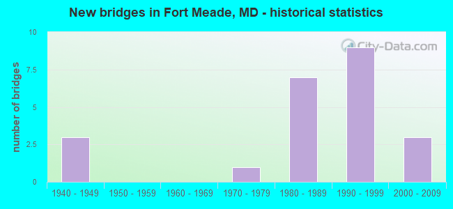
- New bridges - historical statistics
- 31940-1949
- 11970-1979
- 71980-1989
- 91990-1999
- 32000-2009


- Bridge Condition - Deck
- 50.0%Good
- 41.7%Satisfactory
- 8.3%Fair

- Bridge Condition - Superstructure
- 8.3%Very good
- 66.7%Good
- 8.3%Satisfactory
- 8.3%Fair
- 8.3%Poor

- Bridge Condition - Substructure
- 50.0%Good
- 33.3%Satisfactory
- 16.7%Fair

- Bridge Condition - Channel
- 12.5%Good
- 75.0%Satisfactory
- 12.5%Serious

- Bridge Condition - Culverts
- 75.0%Satisfactory
- 25.0%Fair
Find on map >> Show street view
Structure Number: 51640-0074, Location: N TRACT NW END SOLD. LAKE (Lat: 39.085333, Lng: -76.734833), Route carried "on" structure: Federal lands road , Year Built: 1989, Status: Open, Structure Length: 0.76m (2.49ft), Average Daily Traffic: 40 (year 2021), Average Future Daily Traffic: 40 (year 2041), Features Intersected: SPILLWAY TO WETLANDS, Facility Carried by Structure: LAKE ALLEN ROAD
Minimum Vertical Clearance: 30.48m (100.00ft), Kilometerpoint: 0.805, Lanes on structure: 2, Owner: Bureau of Fish and Wildlife, Approaching Roadway Width: 7.9m (25.9ft), Material/Design: Concrete, Design/Construction: Culvert, Number Of Spans In Main Unit: 4, Length of Maximum Span: 1.5m (4.9ft), Curb-To-Curb Width: 8.0m (26.2ft), Out-to-Out Width: 17.4m (57.1ft)
Condition: Channel: Satisfactory, Culverts: Satisfactory, Operating Rating: 36.3 metric tons, Method Used To Determine Operating Rating: Field evaluation and documented engineering judgment, Inventory Rating: 32.7 metric tons, Method Used To Determine Inventory Rating: Field evaluation and documented engineering judgment, Structural Evaluation: Equal to present minimum criteria, Deck Geometry: Equal to present minimum criteria, Waterway Adequacy: Better than present minimum criteria, Approach Roadway Alignment: Better than present minimum criteria, Designated Inspection Frequency: Every 24 months, Inspection Date: August 2021
Find on map >> Show street view
Structure Number: 100000020209013, Location: 1.54 MILE WEST OF MD 170 (Lat: 39.091981, Lng: -76.717258), Route carried "on" structure: State highway 32, Year Built: 1989, Status: Open, Structure Length: 4.48m (14.70ft), Average Daily Traffic: 50,192 (year 2009), Truck Traffic: 8%, Average Future Daily Traffic: 28,907 (year 2026), Design Load: HS 20, Features Intersected: MD 175
Minimum Vertical Clearance: 30+ m (98+ ft), Kilometerpoint: 9.759, Lanes on structure: 3, Lanes under structure: 4, Base Highway Network: Yes, Owner: State Highway Agency, Approaching Roadway Width: 13.4m (44.0ft), Material/Design: Steel, Design/Construction: Stringer/Multi-beam, Number Of Spans In Main Unit: 1, Length of Maximum Span: 43.3m (142.1ft), Curb-To-Curb Width: 13.4m (44.0ft), Out-to-Out Width: 14.6m (47.9ft)
Condition: Deck: Good, Superstructure: Good, Substructure: Good, Operating Rating: 60.8 metric tons, Method Used To Determine Operating Rating: Load Factor (LF), Inventory Rating: 36.3 metric tons, Method Used To Determine Inventory Rating: Load Factor (LF), Structural Evaluation: Better than present minimum criteria, Deck Geometry: High priority of replacement, Underclear: Superior to present desirable criteria, Approach Roadway Alignment: Equal to present desirable criteria, Length Of Structure Improvement: 4.48m (14.70ft), Designated Inspection Frequency: Every 24 months, Inspection Date: March 2020, Bridge Improvement Cost: $423,000, Roadway Improvement Cost: $42,000, Total Project Cost: $465,000, Deck Structure Type: Concrete Cast-file-Place, Wearing Surface/Protective System: Wearing Surface: Monolithic Concrete, Deck Protection: Epoxy Coated Reinforcing
Find on map >> Show street view
Structure Number: 100000020209014, Location: 1.54 MI W OF MD 170 (Lat: 39.092450, Lng: -76.717197), Route carried "on" structure: State highway 32, Year Built: 1989, Status: Open, Structure Length: 4.48m (14.70ft), Average Daily Traffic: 50,192 (year 2009), Truck Traffic: 8%, Average Future Daily Traffic: 28,907 (year 2026), Design Load: HS 20, Features Intersected: MD 175
Minimum Vertical Clearance: 30+ m (98+ ft), Kilometerpoint: 9.759, Lanes on structure: 2, Lanes under structure: 4, Base Highway Network: Yes, Owner: State Highway Agency, Approaching Roadway Width: 13.4m (44.0ft), Material/Design: Steel, Design/Construction: Stringer/Multi-beam, Number Of Spans In Main Unit: 1, Length of Maximum Span: 43.3m (142.1ft), Curb-To-Curb Width: 13.4m (44.0ft), Out-to-Out Width: 14.6m (47.9ft)
Condition: Deck: Good, Superstructure: Good, Substructure: Good, Operating Rating: 60.8 metric tons, Method Used To Determine Operating Rating: Load Factor (LF), Inventory Rating: 36.3 metric tons, Method Used To Determine Inventory Rating: Load Factor (LF), Structural Evaluation: Better than present minimum criteria, Deck Geometry: Superior to present desirable criteria, Underclear: Superior to present desirable criteria, Approach Roadway Alignment: Equal to present desirable criteria, Length Of Structure Improvement: 4.48m (14.70ft), Designated Inspection Frequency: Every 24 months, Inspection Date: March 2020, Bridge Improvement Cost: $423,000, Roadway Improvement Cost: $42,000, Total Project Cost: $465,000, Deck Structure Type: Concrete Cast-file-Place, Wearing Surface/Protective System: Wearing Surface: Monolithic Concrete, Deck Protection: Epoxy Coated Reinforcing
Find on map >> Show street view
Structure Number: 10000002021201, Location: AT MD 32 (Lat: 39.088400, Lng: -76.721978), Route carried "on" structure: County highway , Year Built: 1990, Status: Open, Structure Length: 7.16m (23.49ft), Average Daily Traffic: 51,740 (year 2007), Truck Traffic: 5%, Average Future Daily Traffic: 59,656 (year 2027), Design Load: HS 20+Mod, Features Intersected: MD 32, Facility Carried by Structure: PEPPER ROAD
Minimum Vertical Clearance: 30+ m (98+ ft), Kilometerpoint: 0.080, Lanes on structure: 2, Lanes under structure: 4, Owner: State Highway Agency, Approaching Roadway Width: 13.4m (44.0ft), Material/Design: Steel continuous, Design/Construction: Stringer/Multi-beam, Number Of Spans In Main Unit: 2, Length of Maximum Span: 35.1m (115.2ft), Curb-To-Curb Width: 12.2m (40.0ft), Out-to-Out Width: 13.2m (43.3ft)
Condition: Deck: Good, Superstructure: Good, Substructure: Good, Operating Rating: 64.9 metric tons, Method Used To Determine Operating Rating: Load Factor (LF), Inventory Rating: 38.5 metric tons, Method Used To Determine Inventory Rating: Load Factor (LF), Structural Evaluation: Better than present minimum criteria, Deck Geometry: Somewhat better than minimum adequacy, Underclear: Somewhat better than minimum adequacy, Approach Roadway Alignment: Equal to present desirable criteria, Designated Inspection Frequency: Every 24 months, Inspection Date: September 2020, Deck Structure Type: Concrete Cast-file-Place, Wearing Surface/Protective System: Wearing Surface: Monolithic Concrete, Deck Protection: Epoxy Coated Reinforcing
Find on map >> Show street view
Structure Number: 100000020215013, Location: 2.02 MILE NORTH OF MD 198 (Lat: 0.000108, Lng: -0.000214), Route carried "on" structure: State highway 32, Year Built: 1992, Status: Open, Structure Length: 5.00m (16.40ft), Average Daily Traffic: 65,902 (year 2009), Truck Traffic: 7%, Average Future Daily Traffic: 35,473 (year 2026), Design Load: HS 20, Features Intersected: MD 295
Minimum Vertical Clearance: 30+ m (98+ ft), Kilometerpoint: 16.721, Lanes on structure: 3, Lanes under structure: 6, Base Highway Network: Yes, Owner: State Highway Agency, Approaching Roadway Width: 12.8m (42.0ft), Skew: 1 degrees, Material/Design: Prestressed concrete continuous, Design/Construction: Box Beam or Girders - Multiple, Number Of Spans In Main Unit: 2, Length of Maximum Span: 25.0m (82.0ft), Curb-To-Curb Width: 12.8m (42.0ft), Out-to-Out Width: 13.4m (44.0ft)
Condition: Deck: Satisfactory, Superstructure: Satisfactory, Substructure: Satisfactory, Operating Rating: 43.5 metric tons, Method Used To Determine Operating Rating: Field evaluation and documented engineering judgment, Inventory Rating: 32.7 metric tons, Method Used To Determine Inventory Rating: Field evaluation and documented engineering judgment, Structural Evaluation: Equal to present minimum criteria, Deck Geometry: High priority of replacement, Underclear: Equal to present minimum criteria, Approach Roadway Alignment: Equal to present desirable criteria, Length Of Structure Improvement: 5.00m (16.40ft), Designated Inspection Frequency: Every 24 months, Inspection Date: September 2021, Bridge Improvement Cost: $433,000, Roadway Improvement Cost: $43,000, Total Project Cost: $476,000, Deck Structure Type: Concrete Cast-file-Place, Wearing Surface/Protective System: Wearing Surface: Bituminous
Find on map >> Show street view
Structure Number: 100000020215014, Location: 2.02 MILE NORTH OF MD 198 (Lat: 0.000108, Lng: -0.000214), Route carried "on" structure: State highway 32, Year Built: 1992, Status: Open, Structure Length: 4.79m (15.72ft), Average Daily Traffic: 65,902 (year 2009), Truck Traffic: 7%, Average Future Daily Traffic: 35,473 (year 2026), Design Load: HS 20, Features Intersected: MD 295
Minimum Vertical Clearance: 30+ m (98+ ft), Kilometerpoint: 16.721, Lanes on structure: 3, Lanes under structure: 6, Base Highway Network: Yes, Owner: State Highway Agency, Approaching Roadway Width: 13.4m (44.0ft), Skew: 1 degrees, Material/Design: Prestressed concrete continuous, Design/Construction: Box Beam or Girders - Multiple, Number Of Spans In Main Unit: 2, Length of Maximum Span: 23.8m (78.1ft), Curb-To-Curb Width: 13.8m (45.3ft), Out-to-Out Width: 14.4m (47.2ft)
Condition: Deck: Satisfactory, Superstructure: Good, Substructure: Satisfactory, Operating Rating: 43.5 metric tons, Method Used To Determine Operating Rating: Field evaluation and documented engineering judgment, Inventory Rating: 32.7 metric tons, Method Used To Determine Inventory Rating: Field evaluation and documented engineering judgment, Structural Evaluation: Equal to present minimum criteria, Deck Geometry: High priority of corrective action, Underclear: Somewhat better than minimum adequacy, Approach Roadway Alignment: Equal to present desirable criteria, Length Of Structure Improvement: 4.97m (16.31ft), Designated Inspection Frequency: Every 24 months, Inspection Date: September 2021, Bridge Improvement Cost: $414,000, Roadway Improvement Cost: $41,000, Total Project Cost: $455,000, Deck Structure Type: Concrete Cast-file-Place, Wearing Surface/Protective System: Wearing Surface: Bituminous
Find on map >> Show street view
Structure Number: 10000002022601, Location: ENTRANCE TO N.S.A. (Lat: 39.109508, Lng: -76.775042), Route carried "on" structure: Federal lands road 714, Year Built: 2005, Status: Open, Structure Length: 3.11m (10.20ft), Average Daily Traffic: 42,132 (year 2009), Truck Traffic: 8%, Average Future Daily Traffic: 79,792 (year 2029), Design Load: HS 25 or greater, Features Intersected: CANINE ROAD
Minimum Vertical Clearance: 30+ m (98+ ft), Kilometerpoint: 16.170, Lanes on structure: 5, Lanes under structure: 3, Base Highway Network: Yes, Owner: State Highway Agency, Approaching Roadway Width: 27.4m (89.9ft), Skew: 33 degrees, Material/Design: Steel, Design/Construction: Stringer/Multi-beam, Number Of Spans In Main Unit: 1, Length of Maximum Span: 29.6m (97.1ft), Curb-To-Curb Width: 26.8m (87.9ft), Out-to-Out Width: 28.7m (94.2ft)
Condition: Deck: Good, Superstructure: Good, Substructure: Good, Inventory Rating: 70.3 metric tons, Method Used To Determine Inventory Rating: Load Factor (LF), Structural Evaluation: Better than present minimum criteria, Deck Geometry: Superior to present desirable criteria, Underclear: Equal to present minimum criteria, Approach Roadway Alignment: Equal to present desirable criteria, Designated Inspection Frequency: Every 24 months, Inspection Date: August 2021, Deck Structure Type: Concrete Cast-file-Place, Wearing Surface/Protective System: Wearing Surface: Integral Concrete, Membrane: Preformed Fabric, Deck Protection: Epoxy Coated Reinforcing
Find on map >> Show street view
Structure Number: 10000002022801, Location: 0.748 M W OF MD 32 (Lat: 39.091969, Lng: -76.768789), Route carried "on" structure: State highway 198, Year Built: 1970, Status: Open, Structure Length: 2.90m (9.51ft), Average Daily Traffic: 25,492 (year 0006), Average Future Daily Traffic: 29,392 (year 0026), Features Intersected: BR OF LIT PATUXENT RIVER
Minimum Vertical Clearance: 30+ m (98+ ft), Kilometerpoint: 6.109, Lanes on structure: 2, Base Highway Network: Yes, Owner: State Highway Agency, Approaching Roadway Width: 8.5m (27.9ft), Material/Design: Steel continuous, Design/Construction: Stringer/Multi-beam, Number Of Spans In Main Unit: 3, Length of Maximum Span: 9.4m (30.8ft), Curb-To-Curb Width: 8.5m (27.9ft), Out-to-Out Width: 9.4m (30.8ft)
Condition: Deck: Fair, Superstructure: Fair, Substructure: Fair, Channel: Serious, Operating Rating: 32.7 metric tons, Method Used To Determine Operating Rating: Field evaluation and documented engineering judgment, Inventory Rating: 32.7 metric tons, Method Used To Determine Inventory Rating: Field evaluation and documented engineering judgment, Structural Evaluation: Somewhat better than minimum adequacy, Deck Geometry: High priority of replacement, Waterway Adequacy: Somewhat better than minimum adequacy, Approach Roadway Alignment: Equal to present desirable criteria, Designated Inspection Frequency: Every 24 months, Inspection Date: July 2020, Deck Structure Type: Concrete Cast-file-Place, Wearing Surface/Protective System: Wearing Surface: Monolithic Concrete
Find on map >> Show street view
Structure Number: 10000002024201, Location: AT MD 32 (Lat: 0.000108, Lng: -0.000019), Route carried "on" structure: County highway 69, Year Built: 2001, Status: Open, Structure Length: 4.08m (13.39ft), Average Daily Traffic: 21,181 (year 2006), Truck Traffic: 8%, Average Future Daily Traffic: 24,422 (year 2026), Design Load: HS 25 or greater, Features Intersected: MD 32 WBR, Facility Carried by Structure: SAMFORD ROAD
Minimum Vertical Clearance: 30+ m (98+ ft), Kilometerpoint: 0.198, Lanes on structure: 2, Lanes under structure: 2, Owner: State Highway Agency, Approaching Roadway Width: 15.2m (49.9ft), Skew: 3 degrees, Material/Design: Steel, Design/Construction: Stringer/Multi-beam, Number Of Spans In Main Unit: 1, Length of Maximum Span: 38.1m (125.0ft), Curb or Sidewalk Widths: Left: 0.6m (2.0ft), Right: 0.6m (2.0ft), Curb-To-Curb Width: 15.2m (49.9ft), Out-to-Out Width: 16.5m (54.1ft)
Condition: Deck: Good, Superstructure: Very good, Substructure: Good, Operating Rating: 75.3 metric tons, Method Used To Determine Operating Rating: Load Factor (LF), Inventory Rating: 45.4 metric tons, Method Used To Determine Inventory Rating: Load Factor (LF), Structural Evaluation: Better than present minimum criteria, Deck Geometry: Superior to present desirable criteria, Underclear: Equal to present minimum criteria, Approach Roadway Alignment: Equal to present desirable criteria, Designated Inspection Frequency: Every 24 months, Inspection Date: November 2021, Deck Structure Type: Concrete Cast-file-Place, Wearing Surface/Protective System: Wearing Surface: Integral Concrete, Deck Protection: Epoxy Coated Reinforcing
Find on map >> Show street view
Structure Number: 200000AA400201, Location: 1.0 MILE SOUTH OF MD 32 (Lat: 39.120650, Lng: -76.811931), Route carried "on" structure: County highway 4912, Year Built: 1994, Year Reconstructed: 2000, Status: Open, Structure Length: 3.20m (10.50ft), Average Daily Traffic: 5,466 (year 2018), Truck Traffic: 3%, Average Future Daily Traffic: 7,800 (year 2040), Design Load: HS 20, Features Intersected: LITTLE PATUXENT RIVER, Facility Carried by Structure: BROCK BRIDGE ROAD
Minimum Vertical Clearance: 30+ m (98+ ft), Kilometerpoint: 0.000, Lanes on structure: 2, Base Highway Network: Yes, Owner: County Highway Agency, Approaching Roadway Width: 10.4m (34.1ft), Skew: 2 degrees, Material/Design: Steel, Design/Construction: Stringer/Multi-beam, Number Of Spans In Main Unit: 1, Length of Maximum Span: 30.5m (100.1ft), Curb-To-Curb Width: 10.4m (34.1ft), Out-to-Out Width: 11.3m (37.1ft)
Condition: Deck: Good, Superstructure: Good, Substructure: Good, Channel: Satisfactory, Operating Rating: 73.0 metric tons, Method Used To Determine Operating Rating: Load Factor (LF), Inventory Rating: 44.0 metric tons, Method Used To Determine Inventory Rating: Load Factor (LF), Structural Evaluation: Better than present minimum criteria, Deck Geometry: Meets minimum limits, Waterway Adequacy: Somewhat better than minimum adequacy, Approach Roadway Alignment: Equal to present minimum criteria, Designated Inspection Frequency: Every 24 months, Inspection Date: August 2020, Deck Structure Type: Concrete Cast-file-Place, Wearing Surface/Protective System: Wearing Surface: Integral Concrete, Deck Protection: Epoxy Coated Reinforcing
Find on map >> Show street view
Structure Number: 2130001P, Location: 2.0 MILES FROM MD ROUTE 1 (Lat: 39.116825, Lng: -76.771258), Route carried "on" structure: Spur Federal lands road , Year Built: 1988, Status: Open, Structure Length: 3.08m (10.10ft), Average Daily Traffic: 14,000 (year 2019), Truck Traffic: 1%, Average Future Daily Traffic: 14,000 (year 2039), Design Load: HS 20, Features Intersected: NSA PERIMETER ROAD, Facility Carried by Structure: CONNECTOR ROAD
Minimum Vertical Clearance: 30+ m (98+ ft), Kilometerpoint: 0.000, Lanes on structure: 2, Lanes under structure: 2, Owner: NSA, Approaching Roadway Width: 11.0m (36.1ft), Skew: 20 degrees, Material/Design: Steel, Design/Construction: Stringer/Multi-beam, Number Of Spans In Main Unit: 1, Length of Maximum Span: 29.3m (96.1ft), Curb-To-Curb Width: 16.8m (55.1ft), Out-to-Out Width: 17.7m (58.1ft)
Condition: Deck: Satisfactory, Superstructure: Good, Substructure: Satisfactory, Operating Rating: 70.7 metric tons, Method Used To Determine Operating Rating: Load Factor (LF), Inventory Rating: 42.6 metric tons, Method Used To Determine Inventory Rating: Load Factor (LF), Structural Evaluation: Equal to present minimum criteria, Deck Geometry: Superior to present desirable criteria, Underclear: Better than present minimum criteria, Approach Roadway Alignment: Equal to present desirable criteria, Designated Inspection Frequency: Every 24 months, Inspection Date: March 2021, Bridge Improvement Cost: $168,000, Roadway Improvement Cost: $17,000, Total Project Cost: $252,000 ( Estimate for 2021), Deck Structure Type: Concrete Cast-file-Place
Find on map >> Show street view
Structure Number: DAPMDWMEA000003, Location: .03 MI W LEONARD WOOD AVE (Lat: 39.096889, Lng: -76.744031), Route carried "on" structure: ServiceOther road , Year Built: 1984, Status: Open, Structure Length: 0.62m (2.03ft), Average Daily Traffic: 150 (year 2017), Truck Traffic: 10%, Average Future Daily Traffic: 450 (year 2043), Features Intersected: MIDWAY BRANCH, Facility Carried by Structure: SIMONDS STREET
Minimum Vertical Clearance: 30+ m (98+ ft), Kilometerpoint: 0.000, Lanes on structure: 2, Owner: Army, Approaching Roadway Width: 9.4m (30.8ft), Material/Design: Concrete, Design/Construction: Culvert, Number Of Spans In Main Unit: 4, Length of Maximum Span: 1.2m (3.9ft), Curb-To-Curb Width: 9.4m (30.8ft), Out-to-Out Width: 17.0m (55.8ft)
Condition: Channel: Satisfactory, Culverts: Satisfactory, Operating Rating: 54.5 metric tons, Method Used To Determine Operating Rating: Field evaluation and documented engineering judgment, Inventory Rating: 32.7 metric tons, Method Used To Determine Inventory Rating: Field evaluation and documented engineering judgment, Structural Evaluation: Equal to present minimum criteria, Deck Geometry: Equal to present minimum criteria, Waterway Adequacy: Better than present minimum criteria, Approach Roadway Alignment: Equal to present desirable criteria, Length Of Structure Improvement: 0.76m (2.49ft), Designated Inspection Frequency: Every 24 months, Inspection Date: April 2021, Bridge Improvement Cost: $1,000, Roadway Improvement Cost: $1,000, Total Project Cost: $2,000 ( Estimate for 2021)
Find on map >> Show street view
Structure Number: DAPMDWMEA000004, Location: 0.16 MI. E TAYLOR AVE (Lat: 39.094500, Lng: -76.743331), Route carried "on" structure: ServiceOther road , Year Built: 1940, Status: Open, Structure Length: 0.81m (2.66ft), Average Daily Traffic: 120 (year 2017), Truck Traffic: 12%, Average Future Daily Traffic: 450 (year 2043), Features Intersected: MIDWAY BRANCH, Facility Carried by Structure: BROADFOOT RD
Minimum Vertical Clearance: 30+ m (98+ ft), Kilometerpoint: 0.000, Lanes on structure: 2, Owner: Army, Approaching Roadway Width: 6.1m (20.0ft), Material/Design: Concrete, Design/Construction: Slab, Number Of Spans In Main Unit: 1, Length of Maximum Span: 6.1m (20.0ft), Curb or Sidewalk Widths: Left: 1.4m (4.6ft), Right: 0.0m, Curb-To-Curb Width: 6.1m (20.0ft), Out-to-Out Width: 7.3m (24.0ft)
Condition: Deck: Satisfactory, Superstructure: Good, Substructure: Fair, Channel: Good, Operating Rating: 34.3 metric tons, Method Used To Determine Operating Rating: Field evaluation and documented engineering judgment, Inventory Rating: 26.5 metric tons, Method Used To Determine Inventory Rating: Field evaluation and documented engineering judgment, Structural Evaluation: Somewhat better than minimum adequacy, Deck Geometry: Meets minimum limits, Waterway Adequacy: Equal to present minimum criteria, Approach Roadway Alignment: Equal to present minimum criteria, Bridge Posting: Required (Relationship of Operating Rating to Maximum Legal Load: 20.0 - 29.9% below), Length Of Structure Improvement: 1.47m (4.82ft), Designated Inspection Frequency: Every 24 months, Inspection Date: April 2021, Bridge Improvement Cost: $60,000, Roadway Improvement Cost: $16,000, Total Project Cost: $76,000 ( Estimate for 2021), Deck Structure Type: Concrete Cast-file-Place, Wearing Surface/Protective System: Wearing Surface: Bituminous
Find on map >> Show street view
Structure Number: DAPMDWMEA000005, Location: 0.24 MI. N OF ROCK AVE (Lat: 39.093419, Lng: -76.738889), Route carried "on" structure: ServiceOther road , Year Built: 1944, Status: Open, Structure Length: 0.77m (2.53ft), Average Daily Traffic: 120 (year 2017), Truck Traffic: 10%, Average Future Daily Traffic: 400 (year 2043), Features Intersected: S SIDE FRANKLIN BRANCH, Facility Carried by Structure: REDWOOD ROAD
Minimum Vertical Clearance: 30+ m (98+ ft), Kilometerpoint: 0.000, Lanes on structure: 2, Owner: Army, Approaching Roadway Width: 7.0m (23.0ft), Skew: 5 degrees, Material/Design: Concrete, Design/Construction: Culvert, Number Of Spans In Main Unit: 3, Length of Maximum Span: 2.0m (6.6ft), Curb or Sidewalk Widths: Left: 1.8m (5.9ft), Right: 1.3m (4.3ft), Curb-To-Curb Width: 7.0m (23.0ft), Out-to-Out Width: 15.2m (49.9ft)
Condition: Channel: Satisfactory, Culverts: Fair, Operating Rating: 54.5 metric tons, Method Used To Determine Operating Rating: Field evaluation and documented engineering judgment, Inventory Rating: 32.7 metric tons, Method Used To Determine Inventory Rating: Field evaluation and documented engineering judgment, Structural Evaluation: Somewhat better than minimum adequacy, Deck Geometry: Meets minimum limits, Waterway Adequacy: Better than present minimum criteria, Approach Roadway Alignment: Equal to present desirable criteria, Length Of Structure Improvement: 1.42m (4.66ft), Designated Inspection Frequency: Every 24 months, Inspection Date: April 2021, Bridge Improvement Cost: $1,000, Roadway Improvement Cost: $1,000, Total Project Cost: $2,000 ( Estimate for 2021)
Find on map >> Show street view
Structure Number: DAPMDWMEA000006, Location: 0.10 MILES N ROCK AVE (Lat: 39.091689, Lng: -76.739539), Route carried "on" structure: ServiceOther road , Year Built: 1946, Status: Open, Structure Length: 0.93m (3.05ft), Average Daily Traffic: 200 (year 2017), Truck Traffic: 10%, Average Future Daily Traffic: 400 (year 2043), Features Intersected: MIDWAY BRANCH, Facility Carried by Structure: LEONARD WOOD AVE
Minimum Vertical Clearance: 30+ m (98+ ft), Kilometerpoint: 0.000, Lanes on structure: 2, Owner: Army, Approaching Roadway Width: 7.0m (23.0ft), Skew: 4 degrees, Material/Design: Concrete, Design/Construction: Culvert, Number Of Spans In Main Unit: 3, Length of Maximum Span: 2.4m (7.9ft), Curb-To-Curb Width: 12.5m (41.0ft), Out-to-Out Width: 13.4m (44.0ft)
Condition: Channel: Satisfactory, Culverts: Satisfactory, Operating Rating: 42.4 metric tons, Method Used To Determine Operating Rating: Field evaluation and documented engineering judgment, Inventory Rating: 32.7 metric tons, Method Used To Determine Inventory Rating: Field evaluation and documented engineering judgment, Structural Evaluation: Equal to present minimum criteria, Deck Geometry: Superior to present desirable criteria, Waterway Adequacy: Equal to present minimum criteria, Approach Roadway Alignment: Equal to present desirable criteria, Length Of Structure Improvement: 1.27m (4.17ft), Designated Inspection Frequency: Every 24 months, Inspection Date: April 2021, Bridge Improvement Cost: $1,000, Roadway Improvement Cost: $1,000, Total Project Cost: $2,000 ( Estimate for 2021)
Find on map >> Show street view
Structure Number: DAPMDWMEA000007, Location: .03 MI W LEONARD WOOD AVE (Lat: 39.090400, Lng: -76.739269), Route carried "on" structure: ServiceOther road , Year Built: 1984, Status: Open, Structure Length: 1.60m (5.25ft), Average Daily Traffic: 800 (year 2017), Truck Traffic: 10%, Average Future Daily Traffic: 1,500 (year 2043), Design Load: HS 20, Features Intersected: MIDWAY BRANCH, Facility Carried by Structure: ROCK AVE
Minimum Vertical Clearance: 30+ m (98+ ft), Kilometerpoint: 0.000, Lanes on structure: 2, Owner: Army, Approaching Roadway Width: 9.4m (30.8ft), Skew: 3 degrees, Material/Design: Steel, Design/Construction: Stringer/Multi-beam, Number Of Spans In Main Unit: 1, Length of Maximum Span: 14.3m (46.9ft), Curb or Sidewalk Widths: Left: 1.5m (4.9ft), Right: 0.0m, Curb-To-Curb Width: 8.5m (27.9ft), Out-to-Out Width: 10.9m (35.8ft)
Condition: Deck: Satisfactory, Superstructure: Poor, Substructure: Satisfactory, Channel: Satisfactory, Operating Rating: 61.6 metric tons, Method Used To Determine Operating Rating: Load and Resistance Factor Rating (LRFR) rating reported by rating factor(RF) method using HL-93 loadings, Inventory Rating: 47.3 metric tons, Method Used To Determine Inventory Rating: Load and Resistance Factor Rating (LRFR) rating reported by rating factor(RF) method using HL-93 loadings, Structural Evaluation: Meets minimum limits, Deck Geometry: Somewhat better than minimum adequacy, Waterway Adequacy: Equal to present minimum criteria, Approach Roadway Alignment: Equal to present desirable criteria, Length Of Structure Improvement: 2.29m (7.51ft), Designated Inspection Frequency: Every 24 months, Inspection Date: April 2021, Bridge Improvement Cost: $48,000, Roadway Improvement Cost: $3,000, Total Project Cost: $51,000 ( Estimate for 2021), Deck Structure Type: Concrete Cast-file-Place, Wearing Surface/Protective System: Wearing Surface: Monolithic Concrete
Find on map >> Show street view
Structure Number: 100000020209013, Location: 1.06 MILE NORTH OF MD 170 (Lat: 39.091981, Lng: -76.717258), Route carried "under" structure: State highway 175, Year Built: 1989, Structure Length: 0. m, Average Daily Traffic: 22,022 (year 2009), Truck Traffic: 8%, Features Intersected: MD 175, Facility Carried by Structure: MD 32 EBR
Minimum Vertical Clearance: 4.88m (16.01ft), Kilometerpoint: 6.967, Lanes on structure: 3, Lanes under structure: 4, Material/Design: Steel continuous, Design/Construction: Stringer/Multi-beam, Length of Maximum Span: 26.2m (86.0ft)
Find on map >> Show street view
Structure Number: 100000020209014, Location: 1.06 MILE NORTH OF MD 170 (Lat: 39.092450, Lng: -76.717197), Route carried "under" structure: State highway 175, Year Built: 1993, Structure Length: 0. m, Average Daily Traffic: 22,022 (year 2009), Truck Traffic: 8%, Features Intersected: MD 175, Facility Carried by Structure: MD 32 WBR
Minimum Vertical Clearance: 4.88m (16.01ft), Kilometerpoint: 6.967, Lanes on structure: 2, Lanes under structure: 5, Material/Design: Steel continuous, Design/Construction: Stringer/Multi-beam, Length of Maximum Span: 26.2m (86.0ft)
Find on map >> Show street view
Structure Number: 10000002021201, Location: 0.36 MILE NORTH OF MD 175 (Lat: 39.088400, Lng: -76.721978), Route carried "under" structure: State highway 32, Year Built: 1990, Structure Length: 0. m, Average Daily Traffic: 50,192 (year 2009), Truck Traffic: 8%, Features Intersected: MD 32, Facility Carried by Structure: PEPPER ROAD
Minimum Vertical Clearance: 4.88m (16.01ft), Kilometerpoint: 10.362, Lanes on structure: 2, Lanes under structure: 4, Material/Design: Steel continuous, Design/Construction: Stringer/Multi-beam, Length of Maximum Span: 35.1m (115.2ft)
Find on map >> Show street view
Structure Number: 10000002021401, Location: 2.31 MILE NORTH OF MD 175 (Lat: 39.091247, Lng: -76.757036), Route carried "under" structure: State highway 32, Year Built: 1990, Structure Length: 0. m, Average Daily Traffic: 52,952 (year 2012), Truck Traffic: 8%, Features Intersected: MD 32, Facility Carried by Structure: MD 198 (MAPES RD)
Minimum Vertical Clearance: 5.18m (16.99ft), Kilometerpoint: 13.500, Lanes on structure: 2, Lanes under structure: 4, Material/Design: Steel continuous, Design/Construction: Stringer/Multi-beam, Length of Maximum Span: 41.5m (136.2ft)
Find on map >> Show street view
Structure Number: 100000020215013, Location: 1.75 MILE NORTH OF MD 198 (Lat: 39.114114, Lng: -76.777656), Route carried "under" structure: State highway 295, Year Built: 1992, Structure Length: 0. m, Average Daily Traffic: 81,922 (year 2009), Truck Traffic: 8%, Features Intersected: MD 295, Facility Carried by Structure: MD 32 EBR
Minimum Vertical Clearance: 5.18m (16.99ft), Kilometerpoint: 6.838, Lanes on structure: 3, Lanes under structure: 6, Material/Design: Prestressed concrete continuous, Design/Construction: Box Beam or Girders - Multiple, Length of Maximum Span: 25.0m (82.0ft)
Find on map >> Show street view
Structure Number: 100000020215014, Location: 1.75 MILE NORTH OF MD 198 (Lat: 39.114467, Lng: -76.778153), Route carried "under" structure: State highway 295, Year Built: 1992, Structure Length: 0. m, Average Daily Traffic: 81,922 (year 2009), Truck Traffic: 8%, Features Intersected: MD 295, Facility Carried by Structure: MD 32 WBR
Minimum Vertical Clearance: 4.88m (16.01ft), Kilometerpoint: 6.838, Lanes on structure: 2, Lanes under structure: 6, Material/Design: Prestressed concrete continuous, Design/Construction: Box Beam or Girders - Multiple, Length of Maximum Span: 25.3m (83.0ft)
Find on map >> Show street view
Structure Number: 10000002024201, Location: 1.2 MILES SOUTH OF MD 295 (Lat: 39.098572, Lng: -76.767889), Route carried "under" structure: State highway 32, Year Built: 2001, Structure Length: 0. m, Average Daily Traffic: 24,181 (year 2006), Truck Traffic: 8%, Features Intersected: MD 32 WBR, Facility Carried by Structure: SAMFORD ROAD
Minimum Vertical Clearance: 5.49m (18.01ft), Kilometerpoint: 14.819, Lanes on structure: 2, Lanes under structure: 2, Material/Design: Steel, Design/Construction: Stringer/Multi-beam, Length of Maximum Span: 38.1m (125.0ft)