Bridge Statistics for Dale City, Virginia (VA)
Condition, Traffic, Stress, Structural Evaluation, Project Costs
- National Bridge Inventory (NBI) Statistics
- 22Number of bridges
- 203ft / 61.9mTotal length
- $1,606,000Total costs
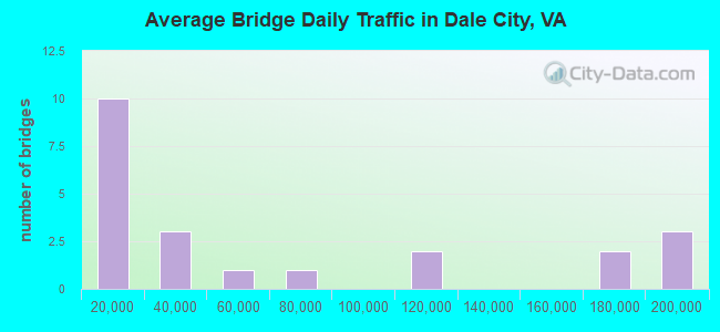
- 1,382,566Total average daily traffic
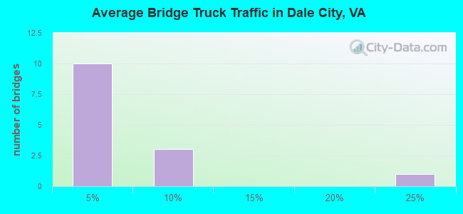
- 51,298Total average daily truck traffic
- National Bridge Inventory (NBI) Registered Bridges for Dale City
- No street view available for this location
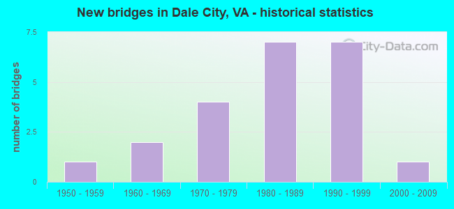
- New bridges - historical statistics
- 11950-1959
- 21960-1969
- 41970-1979
- 71980-1989
- 71990-1999
- 12000-2009
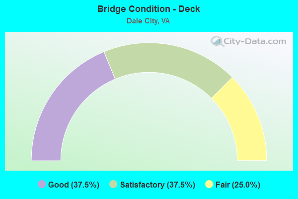
- Bridge Condition - Deck
- 37.5%Good
- 37.5%Satisfactory
- 25.0%Fair
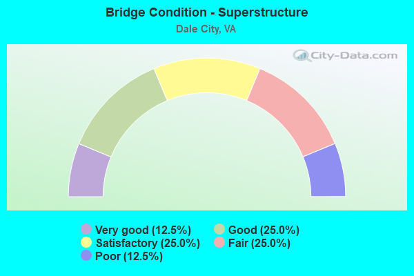
- Bridge Condition - Superstructure
- 12.5%Very good
- 25.0%Good
- 25.0%Satisfactory
- 25.0%Fair
- 12.5%Poor
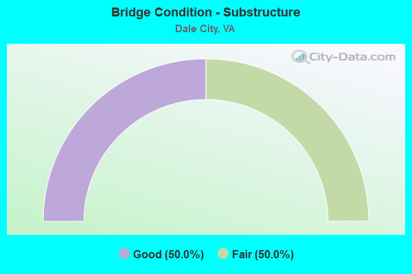
- Bridge Condition - Substructure
- 50.0%Good
- 50.0%Fair
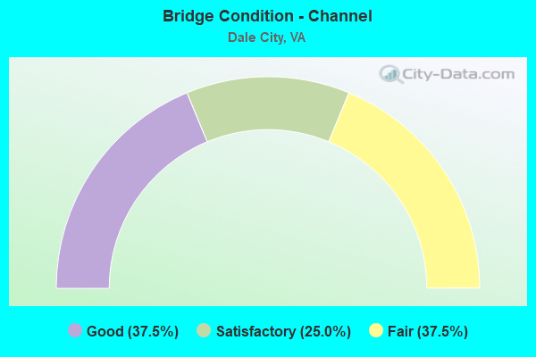
- Bridge Condition - Channel
- 37.5%Good
- 25.0%Satisfactory
- 37.5%Fair
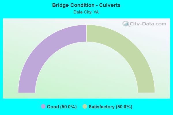
- Bridge Condition - Culverts
- 50.0%Good
- 50.0%Satisfactory
Find on map >> Show street view
Structure Number: 1771, Location: 6.59 RT 612 - 1.07 RT 256 (Lat: 38.273183, Lng: -78.937017), Route carried "on" structure: Interstate 81, Year Built: 1966, Status: Open, Structure Length: 5.85m (19.19ft), Average Daily Traffic: 24,263 (year 2020), Truck Traffic: 24%, Average Future Daily Traffic: 33,968 (year 2040), Design Load: HS 20+Mod, Features Intersected: NS RAILWAY
Minimum Vertical Clearance: 30+ m (98+ ft), Kilometerpoint: 377.697, Lanes on structure: 2, Base Highway Network: Yes, Owner: State Highway Agency, Approaching Roadway Width: 12.2m (40.0ft), Skew: 4 degrees, Material/Design: Steel, Design/Construction: Stringer/Multi-beam, Number Of Spans In Main Unit: 3, Length of Maximum Span: 19.6m (64.3ft), Curb-To-Curb Width: 12.2m (40.0ft), Out-to-Out Width: 12.8m (42.0ft)
Condition: Deck: Fair, Superstructure: Fair, Substructure: Fair, Operating Rating: 56.2 metric tons, Method Used To Determine Operating Rating: Load and Resistance Factor (LRFR), Inventory Rating: 43.5 metric tons, Method Used To Determine Inventory Rating: Load and Resistance Factor (LRFR), Structural Evaluation: Somewhat better than minimum adequacy, Deck Geometry: Better than present minimum criteria, Underclear: Somewhat better than minimum adequacy, Approach Roadway Alignment: Equal to present desirable criteria, Designated Inspection Frequency: Every 24 months, Inspection Date: August 2021, Bridge Improvement Cost: $41,000, Roadway Improvement Cost: $4,000, Total Project Cost: $61,000, Deck Structure Type: Concrete Cast-file-Place, Wearing Surface/Protective System: Wearing Surface: Epoxy Overlay
Find on map >> Show street view
Structure Number: 14234, Location: 02.67FR234/01.07TO784 (Lat: 38.613617, Lng: -77.301381), Route carried "on" structure: Interstate 95, Year Built: 1963, Status: Open, Structure Length: 9.72m (31.89ft), Average Daily Traffic: 68,576 (year 2020), Truck Traffic: 7%, Average Future Daily Traffic: 96,006 (year 2040), Design Load: HS 20+Mod, Features Intersected: NEABSCO CREEK
Minimum Vertical Clearance: 30+ m (98+ ft), Kilometerpoint: 250.489, Lanes on structure: 4, Base Highway Network: Yes, Owner: State Highway Agency, Approaching Roadway Width: 15.8m (51.8ft), Skew: 2 degrees, Material/Design: Steel, Design/Construction: Stringer/Multi-beam, Number Of Spans In Main Unit: 3, Length of Maximum Span: 32.3m (106.0ft), Curb-To-Curb Width: 19.8m (65.0ft), Out-to-Out Width: 20.7m (67.9ft)
Condition: Deck: Fair, Superstructure: Poor, Substructure: Fair, Channel: Satisfactory, Operating Rating: 54.2 metric tons, Method Used To Determine Operating Rating: Load and Resistance Factor (LRFR), Inventory Rating: 41.8 metric tons, Method Used To Determine Inventory Rating: Load and Resistance Factor (LRFR), Structural Evaluation: Meets minimum limits, Deck Geometry: Equal to present minimum criteria, Waterway Adequacy: Superior to present desirable criteria, Approach Roadway Alignment: Equal to present desirable criteria, Length Of Structure Improvement: 9.63m (31.59ft), Designated Inspection Frequency: Every 24 months, Other Special Inspection Frequency: Every 12 months, Inspection Date: April 2021, Other Special Inspection Date: April 2021, Bridge Improvement Cost: $99,000, Roadway Improvement Cost: $199,000, Total Project Cost: $300,000, Deck Structure Type: Concrete Cast-file-Place, Wearing Surface/Protective System: Wearing Surface: Monolithic Concrete
Find on map >> Show street view
Structure Number: 14259, Location: 00.21FR1780/00.20TO95SB (Lat: 38.633750, Lng: -77.293225), Route carried "on" structure: Ramp Interstate 95, Year Built: 1975, Status: Open, Structure Length: 6.00m (19.69ft), Average Daily Traffic: 13,047 (year 2020), Average Future Daily Traffic: 18,266 (year 2040), Design Load: HS 20+Mod, Features Intersected: OLD TELEGRAPH RD.
Minimum Vertical Clearance: 30+ m (98+ ft), Kilometerpoint: 0.000, Lanes on structure: 2, Lanes under structure: 2, Base Highway Network: Yes, Owner: State Highway Agency, Approaching Roadway Width: 9.8m (32.2ft), Skew: 4 degrees, Material/Design: Steel, Design/Construction: Stringer/Multi-beam, Number Of Spans In Main Unit: 4, Length of Maximum Span: 18.6m (61.0ft), Curb or Sidewalk Widths: Left: 0.2m (0.7ft), Right: 0.3m (1.0ft), Curb-To-Curb Width: 11.1m (36.4ft), Out-to-Out Width: 12.2m (40.0ft)
Condition: Deck: Satisfactory, Superstructure: Fair, Substructure: Fair, Operating Rating: 47.9 metric tons, Method Used To Determine Operating Rating: Load Factor (LF), Inventory Rating: 28.7 metric tons, Method Used To Determine Inventory Rating: Load Factor (LF), Structural Evaluation: Somewhat better than minimum adequacy, Deck Geometry: Equal to present desirable criteria, Underclear: High priority of replacement, Approach Roadway Alignment: Equal to present desirable criteria, Length Of Structure Improvement: 7.80m (25.59ft), Designated Inspection Frequency: Every 24 months, Inspection Date: July 2021, Bridge Improvement Cost: $251,000, Roadway Improvement Cost: $25,000, Total Project Cost: $285,000, Deck Structure Type: Concrete Cast-file-Place, Wearing Surface/Protective System: Wearing Surface: Latex Concrete
Find on map >> Show street view
Structure Number: 14294, Location: 01.10 784 / 00.40 640 (Lat: 38.645436, Lng: -77.347064), Route carried "on" structure: County highway 2025, Year Built: 1955, Status: Open, Structure Length: 0.94m (3.08ft), Average Daily Traffic: 2,295 (year 2020), Average Future Daily Traffic: 3,179 (year 2040), Design Load: HS 20+Mod, Features Intersected: NEABSCO CREEK, Facility Carried by Structure: DELANEY ROAD
Minimum Vertical Clearance: 30+ m (98+ ft), Kilometerpoint: 2.108, Lanes on structure: 2, Owner: State Highway Agency, Approaching Roadway Width: 7.3m (24.0ft), Material/Design: Concrete, Design/Construction: Slab, Number Of Spans In Main Unit: 1, Length of Maximum Span: 7.8m (25.6ft), Curb-To-Curb Width: 7.3m (24.0ft), Out-to-Out Width: 7.9m (25.9ft)
Condition: Deck: Good, Superstructure: Very good, Substructure: Good, Channel: Good, Operating Rating: 74.4 metric tons, Method Used To Determine Operating Rating: Load and Resistance Factor (LRFR), Inventory Rating: 57.2 metric tons, Method Used To Determine Inventory Rating: Load and Resistance Factor (LRFR), Structural Evaluation: Better than present minimum criteria, Deck Geometry: High priority of replacement, Waterway Adequacy: Somewhat better than minimum adequacy, Approach Roadway Alignment: Equal to present minimum criteria, Length Of Structure Improvement: 0.03m (0.10ft), Designated Inspection Frequency: Every 24 months, Inspection Date: June 2020, Bridge Improvement Cost: $177,000, Roadway Improvement Cost: $100,000, Total Project Cost: $350,000, Deck Structure Type: Concrete Cast-file-Place
Find on map >> Show street view
Structure Number: 14297, Location: 00.85FR1/03.60TO640 (Lat: 38.611700, Lng: -77.303797), Route carried "on" structure: County highway 610, Year Built: 1996, Status: Open, Structure Length: 12.59m (41.31ft), Average Daily Traffic: 6,824 (year 2020), Truck Traffic: 2%, Average Future Daily Traffic: 9,555 (year 2040), Design Load: HS 20, Features Intersected: I-95, Facility Carried by Structure: CARDINAL DRIVE WBL
Minimum Vertical Clearance: 30+ m (98+ ft), Kilometerpoint: 4.586, Lanes on structure: 2, Lanes under structure: 9, Owner: State Highway Agency, Approaching Roadway Width: 9.8m (32.2ft), Skew: 1 degrees, Material/Design: Steel continuous, Design/Construction: Stringer/Multi-beam, Number Of Spans In Main Unit: 3, Length of Maximum Span: 42.1m (138.1ft), Curb or Sidewalk Widths: Left: 2.1m (6.9ft), Right: 0.0m, Curb-To-Curb Width: 9.8m (32.2ft), Out-to-Out Width: 12.8m (42.0ft)
Condition: Deck: Good, Superstructure: Good, Substructure: Good, Operating Rating: 50.8 metric tons, Method Used To Determine Operating Rating: Load and Resistance Factor (LRFR), Inventory Rating: 39.0 metric tons, Method Used To Determine Inventory Rating: Load and Resistance Factor (LRFR), Structural Evaluation: Better than present minimum criteria, Deck Geometry: Meets minimum limits, Underclear: Equal to present minimum criteria, Approach Roadway Alignment: Equal to present desirable criteria, Length Of Structure Improvement: 12.59m (41.31ft), Designated Inspection Frequency: Every 24 months, Inspection Date: May 2021, Bridge Improvement Cost: $67,000, Roadway Improvement Cost: $99,000, Total Project Cost: $175,000 ( Estimate for 2015), Deck Structure Type: Concrete Cast-file-Place, Wearing Surface/Protective System: Wearing Surface: Monolithic Concrete, Deck Protection: Epoxy Coated Reinforcing
Find on map >> Show street view
Structure Number: 14391, Location: .60Mi.Fr 2068/.35Mi.To638 (Lat: 38.628303, Lng: -77.293825), Route carried "on" structure: County highway 784, Year Built: 1983, Status: Open, Structure Length: 12.83m (42.09ft), Average Daily Traffic: 33,268 (year 2020), Truck Traffic: 2%, Average Future Daily Traffic: 46,575 (year 2040), Design Load: HS 20, Features Intersected: ROUTE I-95, Facility Carried by Structure: DALE BOULEVARD
Minimum Vertical Clearance: 30+ m (98+ ft), Kilometerpoint: 9.799, Lanes on structure: 7, Lanes under structure: 12, Base Highway Network: Yes, Owner: State Highway Agency, Approaching Roadway Width: 33.2m (108.9ft), Skew: 20 degrees, Material/Design: Steel continuous, Design/Construction: Stringer/Multi-beam, Number Of Spans In Main Unit: 5, Length of Maximum Span: 25.9m (85.0ft), Curb or Sidewalk Widths: Left: 0.2m (0.7ft), Right: 0.2m (0.7ft), Curb-To-Curb Width: 33.1m (108.6ft), Out-to-Out Width: 35.3m (115.8ft)
Condition: Deck: Satisfactory, Superstructure: Satisfactory, Substructure: Fair, Operating Rating: 62.0 metric tons, Method Used To Determine Operating Rating: Load and Resistance Factor (LRFR), Inventory Rating: 47.8 metric tons, Method Used To Determine Inventory Rating: Load and Resistance Factor (LRFR), Structural Evaluation: Somewhat better than minimum adequacy, Deck Geometry: Superior to present desirable criteria, Underclear: Somewhat better than minimum adequacy, Approach Roadway Alignment: Equal to present desirable criteria, Length Of Structure Improvement: 12.83m (42.09ft), Designated Inspection Frequency: Every 24 months, Inspection Date: May 2021, Bridge Improvement Cost: $66,000, Roadway Improvement Cost: $99,000, Total Project Cost: $175,000 ( Estimate for 2015), Deck Structure Type: Concrete Cast-file-Place, Wearing Surface/Protective System: Wearing Surface: Monolithic Concrete, Deck Protection: Epoxy Coated Reinforcing
Find on map >> Show street view
Structure Number: 14424, Location: 00.05FR1878/00.05TO1894 (Lat: 38.633008, Lng: -77.336400), Route carried "on" structure: County highway 1826, Year Built: 1973, Status: Open, Structure Length: 1.19m (3.90ft), Average Daily Traffic: 3,920 (year 2020), Truck Traffic: 2%, Average Future Daily Traffic: 4,312 (year 2040), Design Load: HS 20, Features Intersected: NEABSCO CREEK, Facility Carried by Structure: DARBYDALE AVENUE
Minimum Vertical Clearance: 30+ m (98+ ft), Kilometerpoint: 1.726, Lanes on structure: 2, Owner: State Highway Agency, Approaching Roadway Width: 18.0m (59.1ft), Skew: 3 degrees, Material/Design: Concrete, Design/Construction: Culvert, Number Of Spans In Main Unit: 3, Length of Maximum Span: 4.0m (13.1ft), Curb or Sidewalk Widths: Left: 1.2m (3.9ft), Right: 1.2m (3.9ft)
Condition: Channel: Fair, Culverts: Satisfactory, Operating Rating: 89.8 metric tons, Method Used To Determine Operating Rating: Load Factor (LF), Inventory Rating: 89.8 metric tons, Method Used To Determine Inventory Rating: Load Factor (LF), Structural Evaluation: Equal to present minimum criteria, Waterway Adequacy: Better than present minimum criteria, Approach Roadway Alignment: Better than present minimum criteria, Length Of Structure Improvement: 11.80m (38.71ft), Designated Inspection Frequency: Every 24 months, Inspection Date: August 2021, Bridge Improvement Cost: $8,000, Roadway Improvement Cost: $8,000, Total Project Cost: $25,000 ( Estimate for 2015)
Find on map >> Show street view
Structure Number: 1443, Location: 00.10 2086 / 00.05 2256 (Lat: 38.645289, Lng: -77.365925), Route carried "on" structure: County highway 2053, Year Built: 1983, Status: Open, Structure Length: 1.04m (3.41ft), Average Daily Traffic: 3,576 (year 2020), Truck Traffic: 4%, Average Future Daily Traffic: 5,006 (year 2040), Design Load: HS 20, Features Intersected: TRIBUTARY OF NEABSCO CK., Facility Carried by Structure: LINDENDALE ROAD
Minimum Vertical Clearance: 30+ m (98+ ft), Kilometerpoint: 1.487, Lanes on structure: 2, Owner: State Highway Agency, Approaching Roadway Width: 14.6m (47.9ft), Skew: 1 degrees, Material/Design: Concrete, Design/Construction: Culvert, Number Of Spans In Main Unit: 3, Length of Maximum Span: 3.4m (11.2ft)
Condition: Channel: Satisfactory, Culverts: Satisfactory, Operating Rating: 89.8 metric tons, Method Used To Determine Operating Rating: Load Factor (LF), Inventory Rating: 77.1 metric tons, Method Used To Determine Inventory Rating: Load Factor (LF), Structural Evaluation: Equal to present minimum criteria, Waterway Adequacy: Superior to present desirable criteria, Approach Roadway Alignment: Equal to present desirable criteria, Length Of Structure Improvement: 0.30m (0.98ft), Designated Inspection Frequency: Every 24 months, Inspection Date: September 2020, Bridge Improvement Cost: $1,000, Roadway Improvement Cost: $1,000, Total Project Cost: $3,000 ( Estimate for 2014)
Find on map >> Show street view
Structure Number: 24217, Location: 01.00Fr642 / 01.60To3020 (Lat: 38.686486, Lng: -77.377286), Route carried "on" structure: County highway 294, Year Built: 1995, Status: Open, Structure Length: 0.79m (2.59ft), Average Daily Traffic: 23,261 (year 2020), Truck Traffic: 2%, Average Future Daily Traffic: 32,565 (year 2040), Design Load: HS 20, Features Intersected: TRIB. OF CROOKED CREEK, Facility Carried by Structure: PRINCE WILLIAM PKY
Minimum Vertical Clearance: 30+ m (98+ ft), Kilometerpoint: 9.966, Lanes on structure: 4, Base Highway Network: Yes, Owner: State Highway Agency, Approaching Roadway Width: 22.6m (74.1ft), Skew: 3 degrees, Material/Design: Concrete, Design/Construction: Culvert, Number Of Spans In Main Unit: 2, Length of Maximum Span: 4.0m (13.1ft)
Condition: Channel: Fair, Culverts: Good, Operating Rating: 89.8 metric tons, Method Used To Determine Operating Rating: Load Factor (LF), Inventory Rating: 89.8 metric tons, Method Used To Determine Inventory Rating: Load Factor (LF), Structural Evaluation: Better than present minimum criteria, Waterway Adequacy: Equal to present desirable criteria, Approach Roadway Alignment: Equal to present desirable criteria, Length Of Structure Improvement: 18.50m (60.70ft), Designated Inspection Frequency: Every 24 months, Inspection Date: July 2021, Bridge Improvement Cost: $33,000, Roadway Improvement Cost: $54,000, Total Project Cost: $100,000
Find on map >> Show street view
Structure Number: 24661, Location: 02.67FR234/01.07TO784 (Lat: 38.613514, Lng: -77.300933), Route carried "on" structure: Alternate Interstate 95, Year Built: 1996, Status: Open, Structure Length: 9.02m (29.59ft), Average Daily Traffic: 7,008 (year 2020), Truck Traffic: 7%, Average Future Daily Traffic: 9,811 (year 2040), Design Load: HS 20, Features Intersected: NEABSCO CREEK
Minimum Vertical Clearance: 30+ m (98+ ft), Kilometerpoint: 8.206, Lanes on structure: 2, Base Highway Network: Yes, Owner: State Highway Agency, Approaching Roadway Width: 14.0m (45.9ft), Skew: 1 degrees, Material/Design: Steel continuous, Design/Construction: Stringer/Multi-beam, Number Of Spans In Main Unit: 3, Length of Maximum Span: 34.1m (111.9ft), Curb-To-Curb Width: 14.2m (46.6ft), Out-to-Out Width: 15.2m (49.9ft)
Condition: Deck: Good, Superstructure: Good, Substructure: Good, Channel: Good, Operating Rating: 77.9 metric tons, Method Used To Determine Operating Rating: Load and Resistance Factor (LRFR), Inventory Rating: 60.1 metric tons, Method Used To Determine Inventory Rating: Load and Resistance Factor (LRFR), Structural Evaluation: Better than present minimum criteria, Deck Geometry: Superior to present desirable criteria, Waterway Adequacy: Equal to present desirable criteria, Approach Roadway Alignment: Equal to present desirable criteria, Length Of Structure Improvement: 0.30m (0.98ft), Designated Inspection Frequency: Every 24 months, Inspection Date: April 2021, Bridge Improvement Cost: $1,000, Roadway Improvement Cost: $2,000, Total Project Cost: $4,000, Deck Structure Type: Concrete Cast-file-Place, Wearing Surface/Protective System: Deck Protection: Epoxy Coated Reinforcing
Find on map >> Show street view
Structure Number: 25144, Location: 00.10FR1857/00.10TO 3798 (Lat: 38.625306, Lng: -77.313333), Route carried "on" structure: County highway 2480, Year Built: 1997, Status: Open, Structure Length: 1.22m (4.00ft), Average Daily Traffic: 16,085 (year 2009), Average Future Daily Traffic: 18,578 (year 2040), Design Load: HS 20, Features Intersected: TRIB. OF NEABSCO CREEK, Facility Carried by Structure: BENITA FITZGERALD
Minimum Vertical Clearance: 30+ m (98+ ft), Kilometerpoint: 0.000, Lanes on structure: 4, Owner: State Highway Agency, Approaching Roadway Width: 19.2m (63.0ft), Skew: 20 degrees, Material/Design: Concrete, Design/Construction: Arch - Deck, Number Of Spans In Main Unit: 1, Length of Maximum Span: 12.2m (40.0ft), Curb-To-Curb Width: 24.1m (79.1ft), Out-to-Out Width: 35.2m (115.5ft)
Condition: Deck: Satisfactory, Superstructure: Satisfactory, Substructure: Good, Channel: Good, Inventory Rating: 81.3 metric tons, Method Used To Determine Inventory Rating: Load and Resistance Factor (LRFR), Structural Evaluation: Equal to present minimum criteria, Deck Geometry: Superior to present desirable criteria, Waterway Adequacy: Equal to present desirable criteria, Approach Roadway Alignment: Equal to present desirable criteria, Length Of Structure Improvement: 0.30m (0.98ft), Designated Inspection Frequency: Every 24 months, Inspection Date: January 2022, Bridge Improvement Cost: $1,000, Roadway Improvement Cost: $1,000, Total Project Cost: $3,000
Find on map >> Show street view
Structure Number: 29082, Location: 00.15FRHARG/00.10TOTAVER (Lat: 38.670867, Lng: -77.350711), Route carried "on" structure: County highway 3716, Year Built: 2004, Status: Open, Structure Length: 0.70m (2.30ft), Average Daily Traffic: 351 (year 2013), Average Future Daily Traffic: 398 (year 2040), Design Load: HS 20+Mod, Features Intersected: TRIB OF NEABSCO CREEK, Facility Carried by Structure: MONTEGA DR.
Minimum Vertical Clearance: 30+ m (98+ ft), Kilometerpoint: 0.000, Lanes on structure: 2, Owner: State Highway Agency, Approaching Roadway Width: 11.0m (36.1ft), Material/Design: Concrete, Design/Construction: Culvert, Number Of Spans In Main Unit: 2, Length of Maximum Span: 2.7m (8.9ft), Curb or Sidewalk Widths: Left: 1.2m (3.9ft), Right: 1.2m (3.9ft)
Condition: Channel: Fair, Culverts: Good, Operating Rating: 44.5 metric tons, Method Used To Determine Operating Rating: Field evaluation and documented engineering judgment, Inventory Rating: 32.7 metric tons, Method Used To Determine Inventory Rating: Field evaluation and documented engineering judgment, Structural Evaluation: Better than present minimum criteria, Waterway Adequacy: Equal to present desirable criteria, Approach Roadway Alignment: Equal to present desirable criteria, Length Of Structure Improvement: 0.70m (2.30ft), Designated Inspection Frequency: Every 24 months, Inspection Date: Febuary 2021, Bridge Improvement Cost: $44,000, Roadway Improvement Cost: $72,000, Total Project Cost: $125,000
Find on map >> Show street view
Structure Number: 14259, Location: 00.21FR1780/00.20TO95SB (Lat: 38.633750, Lng: -77.293225), Route carried "under" structure: County highway 1781, Year Built: 1975, Structure Length: 0. m, Average Daily Traffic: 1,592 (year 2004), Features Intersected: OLD TELEGRAPH RD., Facility Carried by Structure: RAMP E OF I-95
Minimum Vertical Clearance: 4.22m (13.85ft), Kilometerpoint: 0.628, Lanes on structure: 2, Lanes under structure: 2, Material/Design: Steel, Design/Construction: Stringer/Multi-beam, Length of Maximum Span: 18.6m (61.0ft)
Find on map >> Show street view
Structure Number: 14297, Location: 00.85FR1/03.60TO640 (Lat: 38.611700, Lng: -77.303797), Route carried "under" structure: Interstate 95, Year Built: 1996, Structure Length: 0. m, Average Daily Traffic: 172,741 (year 2008), Truck Traffic: 4%, Features Intersected: I-95, Facility Carried by Structure: CARDINAL DRIVE WBL
Minimum Vertical Clearance: 6.30m (20.67ft), Kilometerpoint: 250.087, Lanes on structure: 2, Lanes under structure: 3, Material/Design: Steel continuous, Design/Construction: Stringer/Multi-beam, Length of Maximum Span: 42.1m (138.1ft)
Find on map >> Show street view
Structure Number: 14297, Location: 00.85FR1/03.60TO640 (Lat: 38.611700, Lng: -77.303797), Route carried "under" structure: Interstate 95, Year Built: 1996, Structure Length: 0. m, Average Daily Traffic: 50,000 (year 1994), Truck Traffic: 5%, Features Intersected: I-95, Facility Carried by Structure: CARDINAL DRIVE WBL
Minimum Vertical Clearance: 6.40m (21.00ft), Kilometerpoint: 7.836, Lanes on structure: 2, Lanes under structure: 3, Material/Design: Steel continuous, Design/Construction: Stringer/Multi-beam, Length of Maximum Span: 42.1m (138.1ft)
Find on map >> Show street view
Structure Number: 14297, Location: 00.85FR1/03.60TO640 (Lat: 38.611700, Lng: -77.303797), Route carried "under" structure: Interstate 95, Year Built: 1996, Structure Length: 0. m, Average Daily Traffic: 172,741 (year 2008), Truck Traffic: 4%, Features Intersected: I-95, Facility Carried by Structure: CARDINAL DRIVE WBL
Minimum Vertical Clearance: 5.79m (19.00ft), Kilometerpoint: 250.087, Lanes on structure: 2, Lanes under structure: 3, Material/Design: Steel continuous, Design/Construction: Stringer/Multi-beam, Length of Maximum Span: 42.1m (138.1ft)
Find on map >> Show street view
Structure Number: 14391, Location: .60Mi.Fr 2068/.35Mi.To638 (Lat: 38.628303, Lng: -77.293825), Route carried "under" structure: Interstate 95, Year Built: 1983, Structure Length: 0. m, Average Daily Traffic: 106,000 (year 1994), Features Intersected: ROUTE I-95, Facility Carried by Structure: DALE BOULEVARD
Minimum Vertical Clearance: 5.41m (17.75ft), Kilometerpoint: 253.257, Lanes on structure: 7, Lanes under structure: 2, Material/Design: Steel continuous, Design/Construction: Stringer/Multi-beam, Length of Maximum Span: 25.9m (85.0ft)
Find on map >> Show street view
Structure Number: 14391, Location: .60Mi.Fr 2068/.35Mi.To638 (Lat: 38.628303, Lng: -77.293825), Route carried "under" structure: Interstate 95, Year Built: 1983, Structure Length: 0. m, Average Daily Traffic: 106,000 (year 1994), Features Intersected: ROUTE I-95, Facility Carried by Structure: DALE BOULEVARD
Minimum Vertical Clearance: 5.28m (17.32ft), Kilometerpoint: 253.257, Lanes on structure: 7, Lanes under structure: 3, Material/Design: Steel continuous, Design/Construction: Stringer/Multi-beam, Length of Maximum Span: 25.9m (85.0ft)
Find on map >> Show street view
Structure Number: 14391, Location: .60Mi.Fr 2068/.35Mi.To638 (Lat: 38.628303, Lng: -77.293825), Route carried "under" structure: Interstate 95, Year Built: 1983, Structure Length: 0. m, Average Daily Traffic: 186,506 (year 2008), Truck Traffic: 4%, Features Intersected: ROUTE I-95, Facility Carried by Structure: DALE BOULEVARD
Minimum Vertical Clearance: 5.33m (17.49ft), Kilometerpoint: 253.257, Lanes on structure: 7, Lanes under structure: 2, Material/Design: Steel continuous, Design/Construction: Stringer/Multi-beam, Length of Maximum Span: 25.9m (85.0ft)
Find on map >> Show street view
Structure Number: 14391, Location: .60Mi.Fr 2068/.35Mi.To638 (Lat: 38.628303, Lng: -77.293825), Route carried "under" structure: Interstate 95, Year Built: 1983, Structure Length: 0. m, Average Daily Traffic: 186,506 (year 2008), Truck Traffic: 4%, Features Intersected: ROUTE I-95, Facility Carried by Structure: DALE BOULEVARD
Minimum Vertical Clearance: 5.21m (17.09ft), Kilometerpoint: 253.257, Lanes on structure: 7, Lanes under structure: 3, Material/Design: Steel continuous, Design/Construction: Stringer/Multi-beam, Length of Maximum Span: 25.9m (85.0ft)
Find on map >> Show street view
Structure Number: 14391, Location: .60Mi.Fr 2068/.35Mi.To638 (Lat: 38.628303, Lng: -77.293825), Route carried "under" structure: Ramp Interstate 95, Year Built: 1983, Structure Length: 0. m, Average Daily Traffic: 186,506 (year 2008), Truck Traffic: 4%, Features Intersected: ROUTE I-95, Facility Carried by Structure: DALE BOULEVARD
Minimum Vertical Clearance: 5.21m (17.09ft), Kilometerpoint: 253.257, Lanes on structure: 7, Lanes under structure: 2, Material/Design: Steel continuous, Design/Construction: Stringer/Multi-beam, Length of Maximum Span: 25.9m (85.0ft)
Find on map >> Show street view
Structure Number: 14419, Location: 0.15FR1781 / 0.35TO2068 (Lat: 38.632289, Lng: -77.296289), Route carried "under" structure: Ramp Interstate 95, Year Built: 1975, Structure Length: 0. m, Average Daily Traffic: 11,500 (year 1994), Features Intersected: NW RAMP E OF RT I-95, Facility Carried by Structure: POTOMAC MILLS ROAD
Minimum Vertical Clearance: 5.36m (17.59ft), Kilometerpoint: 0.000, Lanes on structure: 2, Lanes under structure: 1, Material/Design: Steel, Design/Construction: Stringer/Multi-beam, Length of Maximum Span: 16.2m (53.1ft)