Bridge Statistics for Cody, Wyoming (WY)
Condition, Traffic, Stress, Structural Evaluation, Project Costs
- National Bridge Inventory (NBI) Statistics
- 16Number of bridges
- 292ft / 88.6mTotal length
- $111,000Total costs
- 65,722Total average daily traffic
- 3,387Total average daily truck traffic
- 91,952Total future (year 2041) average daily traffic
- National Bridge Inventory (NBI) Registered Bridges for Cody
- No street view available for this location
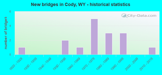
- New bridges - historical statistics
- 11920-1929
- 21950-1959
- 11960-1969
- 51970-1979
- 31980-1989
- 31990-1999
- 12010-2019
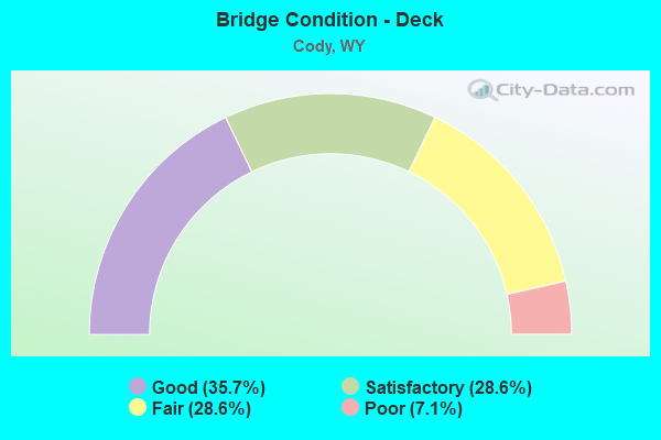
- Bridge Condition - Deck
- 35.7%Good
- 28.6%Satisfactory
- 28.6%Fair
- 7.1%Poor
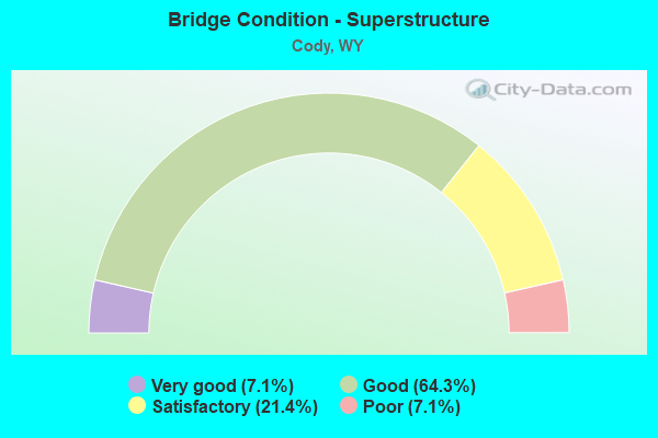
- Bridge Condition - Superstructure
- 7.1%Very good
- 64.3%Good
- 21.4%Satisfactory
- 7.1%Poor
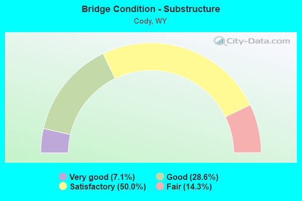
- Bridge Condition - Substructure
- 7.1%Very good
- 28.6%Good
- 50.0%Satisfactory
- 14.3%Fair
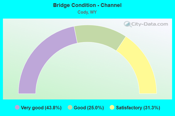
- Bridge Condition - Channel
- 43.8%Very good
- 25.0%Good
- 31.3%Satisfactory
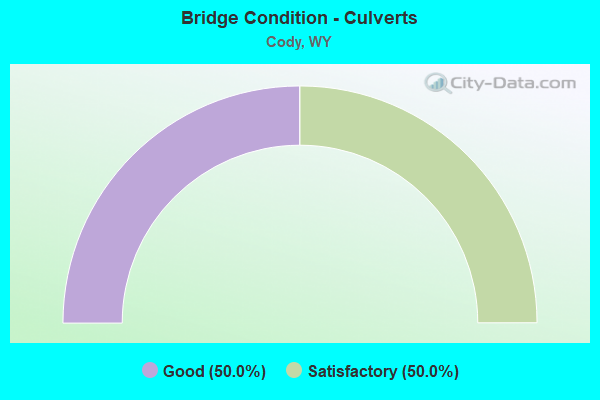
- Bridge Condition - Culverts
- 50.0%Good
- 50.0%Satisfactory
Find on map >> Show street view
Structure Number: WYA-S-001, Location: 5.7 mi W-SW of Cody WY (Lat: 44.508381, Lng: -109.168636), Route carried "on" structure: Spur Federal lands road , Year Built: 1986, Status: Open, Structure Length: 8.42m (27.62ft), Average Daily Traffic: 100 (year 2013), Average Future Daily Traffic: 110 (year 2041), Design Load: HS 20+Mod, Features Intersected: Shoshone River, Facility Carried by Structure: Reclamation Road
Minimum Vertical Clearance: 30+ m (98+ ft), Kilometerpoint: 0.000, Lanes on structure: 2, Lanes under structure: 1, Owner: Bureau of Reclamation, Approaching Roadway Width: 9.1m (29.9ft), Material/Design: Steel, Design/Construction: Stringer/Multi-beam, Number Of Spans In Main Unit: 3, Length of Maximum Span: 33.5m (109.9ft), Curb-To-Curb Width: 5.5m (18.0ft), Out-to-Out Width: 6.2m (20.3ft)
Condition: Deck: Good, Superstructure: Satisfactory, Substructure: Good, Channel: Very good, Operating Rating: 45.0 metric tons, Method Used To Determine Operating Rating: Allowable Stress (AS), Inventory Rating: 27.9 metric tons, Method Used To Determine Inventory Rating: Allowable Stress (AS), Structural Evaluation: Equal to present minimum criteria, Deck Geometry: Meets minimum limits, Underclear: High priority of corrective action, Waterway Adequacy: Superior to present desirable criteria, Approach Roadway Alignment: High priority of corrective action, Designated Inspection Frequency: Every 24 months, Inspection Date: August 2021, Bridge Improvement Cost: $5,000, Roadway Improvement Cost: $4,000, Total Project Cost: $9,000 ( Estimate for 2020), Deck Structure Type: Concrete Cast-file-Place
Find on map >> Show street view
Structure Number: WYA-S-002, Location: 4.5 mi W-SW of Cody WY (Lat: 44.510283, Lng: -109.147144), Route carried "on" structure: Spur County highway , Year Built: 1924, Status: Posted for load, Structure Length: 4.86m (15.94ft), Average Daily Traffic: 100 (year 2013), Average Future Daily Traffic: 110 (year 2041), Design Load: H 15, Features Intersected: Shoshone River, Facility Carried by Structure: Hayden Arch Road
Minimum Vertical Clearance: 30+ m (98+ ft), Kilometerpoint: 0.000, Lanes on structure: 2, Owner: Bureau of Reclamation, Approaching Roadway Width: 7.9m (25.9ft), Skew: 2 degrees, Material/Design: Concrete, Design/Construction: Arch - Deck, Number Of Spans In Main Unit: 1, Number Of Approach Spans: 1, Length of Maximum Span: 37.8m (124.0ft), Curb-To-Curb Width: 6.1m (20.0ft), Out-to-Out Width: 7.0m (23.0ft)
Condition: Deck: Poor, Superstructure: Poor, Substructure: Fair, Channel: Good, Operating Rating: 41.4 metric tons, Method Used To Determine Operating Rating: Allowable Stress (AS), Inventory Rating: 23.4 metric tons, Method Used To Determine Inventory Rating: Allowable Stress (AS), Structural Evaluation: Meets minimum limits, Deck Geometry: Somewhat better than minimum adequacy, Waterway Adequacy: Superior to present desirable criteria, Approach Roadway Alignment: Equal to present minimum criteria, Designated Inspection Frequency: Every 24 months, Underwater Inspection Frequency: Every 60 months, Inspection Date: August 2021, Underwater Inspection Date: October 2018, Bridge Improvement Cost: $71,000, Roadway Improvement Cost: $6,000, Total Project Cost: $77,000 ( Estimate for 2020), Deck Structure Type: Concrete Cast-file-Place
Find on map >> Show street view
Structure Number: BQY, Location: Thermopolis - Cody (Lat: 44.509561, Lng: -109.025883), Route carried "on" structure: State highway 120, Year Built: 1970, Status: Open, Structure Length: 1.04m (3.41ft), Average Daily Traffic: 2,639 (year 2021), Truck Traffic: 11%, Average Future Daily Traffic: 3,695 (year 2041), Design Load: HS 20, Features Intersected: Alkali Lake
Minimum Vertical Clearance: 30+ m (98+ ft), Kilometerpoint: 131.215, Lanes on structure: 2, Base Highway Network: Yes (Inventory Route: ML3, Subroute: 2), Owner: State Highway Agency, Approaching Roadway Width: 11.6m (38.1ft), Material/Design: Concrete, Design/Construction: Frame, Number Of Spans In Main Unit: 1, Length of Maximum Span: 9.1m (29.9ft), Curb-To-Curb Width: 11.0m (36.1ft), Out-to-Out Width: 11.6m (38.1ft)
Condition: Deck: Good, Superstructure: Good, Substructure: Satisfactory, Channel: Good, Operating Rating: 63.7 metric tons, Method Used To Determine Operating Rating: Load Factor (LF), Inventory Rating: 31.4 metric tons, Method Used To Determine Inventory Rating: Load Factor (LF), Structural Evaluation: Equal to present minimum criteria, Deck Geometry: Somewhat better than minimum adequacy, Waterway Adequacy: Equal to present desirable criteria, Approach Roadway Alignment: Equal to present desirable criteria, Designated Inspection Frequency: Every 24 months, Inspection Date: July 2021, Deck Structure Type: Concrete Cast-file-Place, Wearing Surface/Protective System: Wearing Surface: Epoxy Overlay
Find on map >> Show street view
Structure Number: BZT, Location: Yellowstone Park - Cody (Lat: 44.510767, Lng: -109.158169), Route carried "on" structure: US 14, Year Built: 1960, Year Reconstructed: 2003, Status: Open, Structure Length: 18.11m (59.42ft), Average Daily Traffic: 2,684 (year 2021), Truck Traffic: 4%, Average Future Daily Traffic: 3,758 (year 2041), Design Load: HS 20, Features Intersected: Shoshone Rvr/US 14/20
Minimum Vertical Clearance: 30+ m (98+ ft), Kilometerpoint: 74.031, Lanes on structure: 2, Base Highway Network: Yes, Owner: State Highway Agency, Approaching Roadway Width: 12.2m (40.0ft), Skew: 3 degrees, Material/Design: Steel continuous, Design/Construction: Stringer/Multi-beam, Number Of Spans In Main Unit: 3, Number Of Approach Spans: 2, Length of Maximum Span: 47.5m (155.8ft), Curb-To-Curb Width: 12.1m (39.7ft), Out-to-Out Width: 13.2m (43.3ft)
Condition: Deck: Fair, Superstructure: Good, Substructure: Fair, Channel: Very good, Operating Rating: 57.2 metric tons, Method Used To Determine Operating Rating: Load Factor (LF), Inventory Rating: 34.3 metric tons, Method Used To Determine Inventory Rating: Load Factor (LF), Structural Evaluation: Somewhat better than minimum adequacy, Deck Geometry: Somewhat better than minimum adequacy, Waterway Adequacy: Equal to present desirable criteria, Approach Roadway Alignment: Somewhat better than minimum adequacy, Length Of Structure Improvement: 0.30m (0.98ft), Designated Inspection Frequency: Every 24 months, Inspection Date: July 2021, Bridge Improvement Cost: $1,000, Roadway Improvement Cost: $1,000, Total Project Cost: $3,000 ( Estimate for 2014), Deck Structure Type: Concrete Cast-file-Place, Wearing Surface/Protective System: Wearing Surface: Latex Concrete
Find on map >> Show street view
Structure Number: BZU, Location: Cody (Lat: 44.512553, Lng: -109.043186), Route carried "on" structure: US 14, Year Built: 1970, Status: Open, Structure Length: 2.53m (8.30ft), Average Daily Traffic: 7,274 (year 2021), Truck Traffic: 6%, Average Future Daily Traffic: 10,184 (year 2041), Design Load: HS 20, Features Intersected: Beck Lake
Minimum Vertical Clearance: 30+ m (98+ ft), Kilometerpoint: 85.437, Lanes on structure: 5, Base Highway Network: Yes, Owner: State Highway Agency, Approaching Roadway Width: 25.6m (84.0ft), Material/Design: Concrete, Design/Construction: Stringer/Multi-beam, Number Of Spans In Main Unit: 1, Length of Maximum Span: 24.4m (80.1ft), Curb-To-Curb Width: 25.6m (84.0ft), Out-to-Out Width: 26.4m (86.6ft)
Condition: Deck: Fair, Superstructure: Good, Substructure: Satisfactory, Channel: Very good, Operating Rating: 83.9 metric tons, Method Used To Determine Operating Rating: Load Factor (LF), Inventory Rating: 39.2 metric tons, Method Used To Determine Inventory Rating: Load Factor (LF), Structural Evaluation: Equal to present minimum criteria, Deck Geometry: Superior to present desirable criteria, Waterway Adequacy: Equal to present desirable criteria, Approach Roadway Alignment: Equal to present desirable criteria, Designated Inspection Frequency: Every 24 months, Inspection Date: July 2021, Deck Structure Type: Concrete Cast-file-Place, Wearing Surface/Protective System: Wearing Surface: Latex Concrete
Find on map >> Show street view
Structure Number: BZW, Location: Cody - Jct Wyo 310 (Lat: 44.511950, Lng: -108.974025), Route carried "on" structure: US 14, Year Built: 1975, Status: Open, Structure Length: 4.11m (13.48ft), Average Daily Traffic: 1,659 (year 2021), Truck Traffic: 6%, Average Future Daily Traffic: 2,323 (year 2041), Design Load: HS 20, Features Intersected: Sage Creek
Minimum Vertical Clearance: 30+ m (98+ ft), Kilometerpoint: 90.947, Lanes on structure: 2, Base Highway Network: Yes, Owner: State Highway Agency, Approaching Roadway Width: 13.4m (44.0ft), Skew: 2 degrees, Material/Design: Steel continuous, Design/Construction: Stringer/Multi-beam, Number Of Spans In Main Unit: 3, Length of Maximum Span: 15.9m (52.2ft), Curb-To-Curb Width: 12.2m (40.0ft), Out-to-Out Width: 13.0m (42.7ft)
Condition: Deck: Satisfactory, Superstructure: Good, Substructure: Good, Channel: Good, Operating Rating: 58.1 metric tons, Method Used To Determine Operating Rating: Load Factor (LF), Inventory Rating: 34.5 metric tons, Method Used To Determine Inventory Rating: Load Factor (LF), Structural Evaluation: Better than present minimum criteria, Deck Geometry: Better than present minimum criteria, Waterway Adequacy: Equal to present desirable criteria, Approach Roadway Alignment: Equal to present desirable criteria, Designated Inspection Frequency: Every 24 months, Inspection Date: July 2021, Deck Structure Type: Concrete Cast-file-Place, Wearing Surface/Protective System: Wearing Surface: Latex Concrete
Find on map >> Show street view
Structure Number: CAE, Location: Cody - Powell (Lat: 44.576283, Lng: -108.972936), Route carried "on" structure: Alternate US 14, Year Built: 1957, Year Reconstructed: 2001, Status: Open, Structure Length: 15.21m (49.90ft), Average Daily Traffic: 7,356 (year 2021), Truck Traffic: 4%, Average Future Daily Traffic: 10,298 (year 2041), Design Load: HS 20, Features Intersected: Shoshone River
Minimum Vertical Clearance: 30+ m (98+ ft), Kilometerpoint: 10.429, Lanes on structure: 3, Base Highway Network: Yes, Owner: State Highway Agency, Approaching Roadway Width: 16.5m (54.1ft), Skew: 3 degrees, Material/Design: Steel continuous, Design/Construction: Stringer/Multi-beam, Number Of Spans In Main Unit: 4, Length of Maximum Span: 41.1m (134.8ft), Curb-To-Curb Width: 16.1m (52.8ft), Out-to-Out Width: 17.1m (56.1ft)
Condition: Deck: Good, Superstructure: Good, Substructure: Satisfactory, Channel: Very good, Operating Rating: 96.2 metric tons, Method Used To Determine Operating Rating: Load Factor (LF), Inventory Rating: 57.2 metric tons, Method Used To Determine Inventory Rating: Load Factor (LF), Structural Evaluation: Equal to present minimum criteria, Deck Geometry: Better than present minimum criteria, Waterway Adequacy: Equal to present desirable criteria, Approach Roadway Alignment: Equal to present desirable criteria, Designated Inspection Frequency: Every 24 months, Underwater Inspection Frequency: Every 60 months, Inspection Date: July 2021, Underwater Inspection Date: September 2019, Deck Structure Type: Concrete Cast-file-Place, Wearing Surface/Protective System: Wearing Surface: Epoxy Overlay, Deck Protection: Epoxy Coated Reinforcing
Find on map >> Show street view
Structure Number: DIW, Location: Thermopolis - Cody (Lat: 44.498503, Lng: -109.025228), Route carried "on" structure: State highway 120, Year Built: 1979, Status: Open, Structure Length: 1.80m (5.91ft), Average Daily Traffic: 2,639 (year 2021), Truck Traffic: 11%, Average Future Daily Traffic: 3,695 (year 2041), Design Load: HS 20, Features Intersected: Cody Canal
Minimum Vertical Clearance: 30+ m (98+ ft), Kilometerpoint: 129.983, Lanes on structure: 2, Base Highway Network: Yes (Inventory Route: ML3, Subroute: 2), Owner: State Highway Agency, Approaching Roadway Width: 11.0m (36.1ft), Material/Design: Steel, Design/Construction: Stringer/Multi-beam, Number Of Spans In Main Unit: 1, Length of Maximum Span: 17.4m (57.1ft), Curb-To-Curb Width: 11.0m (36.1ft), Out-to-Out Width: 11.8m (38.7ft)
Condition: Deck: Good, Superstructure: Good, Substructure: Good, Channel: Satisfactory, Operating Rating: 58.1 metric tons, Method Used To Determine Operating Rating: Load Factor (LF), Inventory Rating: 34.5 metric tons, Method Used To Determine Inventory Rating: Load Factor (LF), Structural Evaluation: Better than present minimum criteria, Deck Geometry: Somewhat better than minimum adequacy, Waterway Adequacy: Equal to present desirable criteria, Approach Roadway Alignment: Equal to present desirable criteria, Designated Inspection Frequency: Every 24 months, Inspection Date: January 2022, Deck Structure Type: Concrete Cast-file-Place, Wearing Surface/Protective System: Wearing Surface: Epoxy Overlay
Find on map >> Show street view
Structure Number: DKF, Location: Skyline Drive Cody (Lat: 44.510897, Lng: -109.080447), Route carried "on" structure: City street 4721, Year Built: 1970, Status: Open, Structure Length: 1.04m (3.41ft), Average Daily Traffic: 1,114 (year 2021), Truck Traffic: 6%, Average Future Daily Traffic: 1,560 (year 2041), Design Load: HS 20, Features Intersected: Cody Canal, Facility Carried by Structure: Skyline Drive
Minimum Vertical Clearance: 30+ m (98+ ft), Kilometerpoint: 156.755, Lanes on structure: 2, Owner: Town or Township Highway Agency, Approaching Roadway Width: 7.1m (23.3ft), Skew: 3 degrees, Material/Design: Concrete, Design/Construction: Tee Beam, Number Of Spans In Main Unit: 1, Length of Maximum Span: 9.8m (32.2ft), Curb-To-Curb Width: 7.1m (23.3ft), Out-to-Out Width: 7.3m (24.0ft)
Condition: Deck: Satisfactory, Superstructure: Satisfactory, Substructure: Satisfactory, Channel: Satisfactory, Operating Rating: 54.5 metric tons, Method Used To Determine Operating Rating: Field evaluation and documented engineering judgment, Inventory Rating: 32.7 metric tons, Method Used To Determine Inventory Rating: Field evaluation and documented engineering judgment, Structural Evaluation: Equal to present minimum criteria, Deck Geometry: High priority of corrective action, Waterway Adequacy: Equal to present desirable criteria, Approach Roadway Alignment: Equal to present minimum criteria, Length Of Structure Improvement: 2.29m (7.51ft), Designated Inspection Frequency: Every 24 months, Inspection Date: March 2021, Bridge Improvement Cost: $7,000, Total Project Cost: $10,000, Deck Structure Type: Concrete Precast Panels
Find on map >> Show street view
Structure Number: FGI, Location: Cody-Yellowstone Road (Lat: 44.516697, Lng: -109.078400), Route carried "on" structure: US 14, Year Built: 1955, Status: Open, Structure Length: 1.10m (3.61ft), Average Daily Traffic: 18,717 (year 2021), Truck Traffic: 3%, Average Future Daily Traffic: 26,204 (year 2041), Features Intersected: Sulphur Creek
Minimum Vertical Clearance: 30+ m (98+ ft), Kilometerpoint: 80.599, Lanes on structure: 5, Base Highway Network: Yes, Owner: State Highway Agency, Approaching Roadway Width: 19.5m (64.0ft), Skew: 2 degrees, Material/Design: Steel, Design/Construction: Culvert, Number Of Spans In Main Unit: 2, Length of Maximum Span: 4.7m (15.4ft)
Condition: Channel: Satisfactory, Culverts: Satisfactory, Operating Rating: 32.7 metric tons, Method Used To Determine Operating Rating: Field evaluation and documented engineering judgment, Inventory Rating: 32.7 metric tons, Method Used To Determine Inventory Rating: Field evaluation and documented engineering judgment, Structural Evaluation: Equal to present minimum criteria, Waterway Adequacy: Equal to present desirable criteria, Approach Roadway Alignment: Equal to present desirable criteria, Designated Inspection Frequency: Every 24 months, Inspection Date: July 2021
Find on map >> Show street view
Structure Number: FLK, Location: T53W R102N S24 (Lat: 44.555264, Lng: -109.090319), Route carried "on" structure: State highway 120, Year Built: 1989, Status: Open, Structure Length: 2.65m (8.69ft), Average Daily Traffic: 2,046 (year 2021), Truck Traffic: 8%, Average Future Daily Traffic: 2,864 (year 2041), Design Load: HS 20, Features Intersected: Heart Mountain Canal
Minimum Vertical Clearance: 30+ m (98+ ft), Kilometerpoint: 165.124, Lanes on structure: 2, Base Highway Network: Yes (Inventory Route: ML150, Subroute: 2), Owner: State Highway Agency, Approaching Roadway Width: 12.2m (40.0ft), Skew: 1 degrees, Material/Design: Prestressed concrete, Design/Construction: Stringer/Multi-beam, Number Of Spans In Main Unit: 1, Length of Maximum Span: 25.6m (84.0ft), Curb-To-Curb Width: 12.2m (40.0ft), Out-to-Out Width: 13.1m (43.0ft)
Condition: Deck: Satisfactory, Superstructure: Good, Substructure: Satisfactory, Channel: Very good, Operating Rating: 54.4 metric tons, Method Used To Determine Operating Rating: Load Factor (LF), Inventory Rating: 32.7 metric tons, Method Used To Determine Inventory Rating: Load Factor (LF), Structural Evaluation: Equal to present minimum criteria, Deck Geometry: Equal to present minimum criteria, Waterway Adequacy: Equal to present desirable criteria, Approach Roadway Alignment: Equal to present desirable criteria, Designated Inspection Frequency: Every 24 months, Inspection Date: January 2022, Deck Structure Type: Concrete Cast-file-Place, Wearing Surface/Protective System: Deck Protection: Epoxy Coated Reinforcing
Find on map >> Show street view
Structure Number: FLL, Location: Cody-Montana State Line (Lat: 44.583303, Lng: -109.114325), Route carried "on" structure: State highway 120, Year Built: 1989, Status: Open, Structure Length: 2.65m (8.69ft), Average Daily Traffic: 2,046 (year 2021), Truck Traffic: 8%, Average Future Daily Traffic: 2,864 (year 2041), Design Load: HS 20, Features Intersected: Cottonwood Creek
Minimum Vertical Clearance: 30+ m (98+ ft), Kilometerpoint: 168.849, Lanes on structure: 2, Base Highway Network: Yes (Inventory Route: ML150, Subroute: 2), Owner: State Highway Agency, Approaching Roadway Width: 12.2m (40.0ft), Skew: 1 degrees, Material/Design: Prestressed concrete, Design/Construction: Stringer/Multi-beam, Number Of Spans In Main Unit: 1, Length of Maximum Span: 25.6m (84.0ft), Curb-To-Curb Width: 12.2m (40.0ft), Out-to-Out Width: 13.1m (43.0ft)
Condition: Deck: Fair, Superstructure: Good, Substructure: Good, Channel: Satisfactory, Operating Rating: 54.4 metric tons, Method Used To Determine Operating Rating: Load Factor (LF), Inventory Rating: 32.7 metric tons, Method Used To Determine Inventory Rating: Load Factor (LF), Structural Evaluation: Better than present minimum criteria, Deck Geometry: Equal to present minimum criteria, Waterway Adequacy: Equal to present desirable criteria, Approach Roadway Alignment: Equal to present desirable criteria, Designated Inspection Frequency: Every 24 months, Inspection Date: July 2021, Deck Structure Type: Concrete Cast-file-Place, Wearing Surface/Protective System: Wearing Surface: Epoxy Overlay, Deck Protection: Epoxy Coated Reinforcing
Find on map >> Show street view
Structure Number: FUV, Location: Cody-Montana State Line (Lat: 44.534419, Lng: -109.062600), Route carried "on" structure: State highway 120, Year Built: 1991, Status: Open, Structure Length: 15.12m (49.61ft), Average Daily Traffic: 5,688 (year 2021), Truck Traffic: 6%, Average Future Daily Traffic: 7,963 (year 2041), Design Load: HS 20, Features Intersected: Shoshone River
Minimum Vertical Clearance: 30+ m (98+ ft), Kilometerpoint: 161.597, Lanes on structure: 2, Base Highway Network: Yes (Inventory Route: ML150, Subroute: 2), Owner: State Highway Agency, Approaching Roadway Width: 17.1m (56.1ft), Skew: 3 degrees, Material/Design: Steel continuous, Design/Construction: Stringer/Multi-beam, Number Of Spans In Main Unit: 3, Length of Maximum Span: 57.6m (189.0ft), Curb or Sidewalk Widths: Left: 2.1m (6.9ft), Right: 2.1m (6.9ft), Curb-To-Curb Width: 17.1m (56.1ft), Out-to-Out Width: 21.3m (69.9ft)
Condition: Deck: Fair, Superstructure: Good, Substructure: Satisfactory, Channel: Very good, Operating Rating: 57.2 metric tons, Method Used To Determine Operating Rating: Load Factor (LF), Inventory Rating: 34.5 metric tons, Method Used To Determine Inventory Rating: Load Factor (LF), Structural Evaluation: Equal to present minimum criteria, Deck Geometry: Superior to present desirable criteria, Waterway Adequacy: Superior to present desirable criteria, Approach Roadway Alignment: Equal to present minimum criteria, Length Of Structure Improvement: 4.69m (15.39ft), Designated Inspection Frequency: Every 24 months, Inspection Date: June 2020, Bridge Improvement Cost: $2,000, Roadway Improvement Cost: $1,000, Total Project Cost: $4,000 ( Estimate for 2014), Deck Structure Type: Concrete Cast-file-Place
Find on map >> Show street view
Structure Number: JLW, Location: South Fork Road (Lat: 44.480519, Lng: -109.112061), Route carried "on" structure: State highway 291, Year Built: 1995, Status: Open, Structure Length: 3.51m (11.52ft), Average Daily Traffic: 3,562 (year 2021), Truck Traffic: 3%, Average Future Daily Traffic: 4,987 (year 2041), Design Load: HS 20, Features Intersected: Cody Canal W Sulphur
Minimum Vertical Clearance: 30+ m (98+ ft), Kilometerpoint: 4.847, Lanes on structure: 2, Owner: State Highway Agency, Approaching Roadway Width: 12.8m (42.0ft), Skew: 4 degrees, Material/Design: Prestressed concrete, Design/Construction: Stringer/Multi-beam, Number Of Spans In Main Unit: 1, Length of Maximum Span: 34.1m (111.9ft), Curb-To-Curb Width: 12.2m (40.0ft), Out-to-Out Width: 13.0m (42.7ft)
Condition: Deck: Satisfactory, Superstructure: Satisfactory, Substructure: Satisfactory, Channel: Satisfactory, Operating Rating: 68.9 metric tons, Method Used To Determine Operating Rating: Allowable Stress (AS), Inventory Rating: 40.8 metric tons, Method Used To Determine Inventory Rating: Allowable Stress (AS), Structural Evaluation: Equal to present minimum criteria, Deck Geometry: Equal to present minimum criteria, Waterway Adequacy: Equal to present desirable criteria, Approach Roadway Alignment: Equal to present desirable criteria, Length Of Structure Improvement: 3.41m (11.19ft), Designated Inspection Frequency: Every 24 months, Inspection Date: January 2022, Bridge Improvement Cost: $5,000, Roadway Improvement Cost: $1,000, Total Project Cost: $8,000, Deck Structure Type: Concrete Cast-file-Place, Wearing Surface/Protective System: Wearing Surface: Bituminous
Find on map >> Show street view
Structure Number: JLX, Location: South Fork Road (Lat: 44.466103, Lng: -109.139142), Route carried "on" structure: State highway 291, Year Built: 1995, Status: Open, Structure Length: 0.92m (3.02ft), Average Daily Traffic: 1,383 (year 2021), Truck Traffic: 5%, Average Future Daily Traffic: 1,936 (year 2041), Design Load: HS 25 or greater, Features Intersected: Cody Canal
Minimum Vertical Clearance: 30+ m (98+ ft), Kilometerpoint: 7.607, Lanes on structure: 2, Owner: State Highway Agency, Approaching Roadway Width: 12.8m (42.0ft), Material/Design: Prestressed concrete, Design/Construction: Culvert, Number Of Spans In Main Unit: 3, Length of Maximum Span: 2.7m (8.9ft)
Condition: Channel: Good, Culverts: Good, Operating Rating: 32.7 metric tons, Method Used To Determine Operating Rating: Field evaluation and documented engineering judgment, Inventory Rating: 32.7 metric tons, Method Used To Determine Inventory Rating: Field evaluation and documented engineering judgment, Structural Evaluation: Better than present minimum criteria, Waterway Adequacy: Better than present minimum criteria, Approach Roadway Alignment: Equal to present desirable criteria, Designated Inspection Frequency: Every 24 months, Inspection Date: January 2022
Find on map >> Show street view
Structure Number: MQB, Location: Cody - Powell (Lat: 44.542128, Lng: -108.992694), Route carried "on" structure: Alternate US 14, Year Built: 2014, Status: Open, Structure Length: 5.49m (18.01ft), Average Daily Traffic: 6,715 (year 2021), Truck Traffic: 6%, Average Future Daily Traffic: 9,401 (year 2041), Design Load: HL 93, Features Intersected: Sage Creek
Minimum Vertical Clearance: 30+ m (98+ ft), Kilometerpoint: 6.045, Lanes on structure: 5, Base Highway Network: Yes, Owner: State Highway Agency, Approaching Roadway Width: 23.0m (75.5ft), Skew: 3 degrees, Material/Design: Steel continuous, Design/Construction: Stringer/Multi-beam, Number Of Spans In Main Unit: 3, Length of Maximum Span: 21.6m (70.9ft), Curb-To-Curb Width: 23.2m (76.1ft), Out-to-Out Width: 24.2m (79.4ft)
Condition: Deck: Good, Superstructure: Very good, Substructure: Very good, Channel: Very good, Operating Rating: 48.9 metric tons, Method Used To Determine Operating Rating: Load and Resistance Factor Rating (LRFR) rating reported by rating factor(RF) method using HL-93 loadings, Inventory Rating: 37.9 metric tons, Method Used To Determine Inventory Rating: Load and Resistance Factor Rating (LRFR) rating reported by rating factor(RF) method using HL-93 loadings, Structural Evaluation: Equal to present desirable criteria, Deck Geometry: Better than present minimum criteria, Waterway Adequacy: Superior to present desirable criteria, Approach Roadway Alignment: Equal to present desirable criteria, Designated Inspection Frequency: Every 24 months, Inspection Date: June 2020, Deck Structure Type: Concrete Cast-file-Place, Wearing Surface/Protective System: Deck Protection: Epoxy Coated Reinforcing