Bridge Statistics for Aztec, New Mexico (NM)
Condition, Traffic, Stress, Structural Evaluation, Project Costs
- National Bridge Inventory (NBI) Statistics
- 23Number of bridges
- 318ft / 96.9mTotal length
- $6,170,000Total costs
- 136,925Total average daily traffic
- 14,757Total average daily truck traffic
- 155,719Total future (year 2040) average daily traffic
- National Bridge Inventory (NBI) Registered Bridges for Aztec
- No street view available for this location
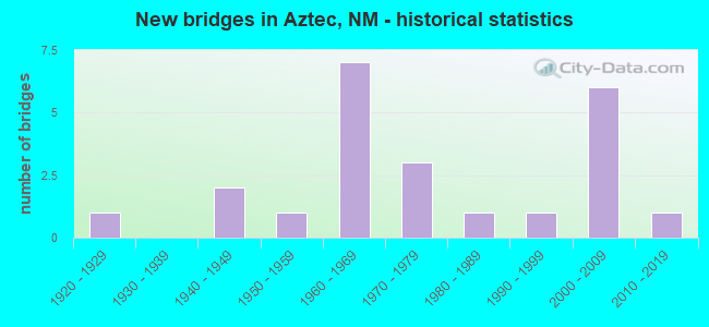
- New bridges - historical statistics
- 11920-1929
- 21940-1949
- 11950-1959
- 71960-1969
- 31970-1979
- 11980-1989
- 11990-1999
- 62000-2009
- 12010-2019

- Reconstructed bridges - Historical Statistics
- 11960-1969
- 01970-1979
- 01980-1989
- 11990-1999


- Bridge Condition - Deck
- 37.5%Good
- 25.0%Satisfactory
- 31.3%Fair
- 6.3%Poor

- Bridge Condition - Superstructure
- 6.3%Very good
- 25.0%Good
- 50.0%Satisfactory
- 12.5%Fair
- 6.3%Poor

- Bridge Condition - Substructure
- 12.5%Very good
- 18.8%Good
- 25.0%Satisfactory
- 43.8%Fair

- Bridge Condition - Channel
- 17.4%Very good
- 26.1%Good
- 43.5%Satisfactory
- 4.3%Fair
- 8.7%Serious

- Bridge Condition - Culverts
- 42.9%Good
- 57.1%Satisfactory
Find on map >> Show street view
Structure Number: 119, Location: 0.01 M E Aztec Blvd (Lat: 36.825653, Lng: -108.003147), Route carried "on" structure: City street 4184, Year Built: 1929, Status: Open, Structure Length: 10.88m (35.70ft), Average Daily Traffic: 5,016 (year 2020), Truck Traffic: 7%, Average Future Daily Traffic: 5,618 (year 2040), Design Load: H 15, Features Intersected: ANIMAS RIVER
Minimum Vertical Clearance: 4.48m (14.70ft), Kilometerpoint: 0.016, Lanes on structure: 2, Owner: State Highway Agency, Approaching Roadway Width: 6.1m (20.0ft), Material/Design: Steel, Design/Construction: Truss - Thru, Number Of Spans In Main Unit: 3, Number Of Approach Spans: 2, Length of Maximum Span: 61.0m (200.1ft), Curb or Sidewalk Widths: Left: 0.0m, Right: 1.5m (4.9ft), Curb-To-Curb Width: 6.2m (20.3ft), Out-to-Out Width: 6.4m (21.0ft)
Condition: Deck: Poor, Superstructure: Poor, Substructure: Fair, Channel: Good, Operating Rating: 53.5 metric tons, Method Used To Determine Operating Rating: Load Factor (LF), Inventory Rating: 24.3 metric tons, Method Used To Determine Inventory Rating: Load Factor (LF), Structural Evaluation: Meets minimum limits, Deck Geometry: High priority of replacement, Waterway Adequacy: Equal to present minimum criteria, Approach Roadway Alignment: Equal to present minimum criteria, Length Of Structure Improvement: 10.90m (35.76ft), Designated Inspection Frequency: Every 12 months, Critical Feature Inspection Frequency: Every 12 months, Inspection Date: September 2021, Critical Feature Inspection Date: September 2021, Bridge Improvement Cost: $359,000, Roadway Improvement Cost: $35,000, Total Project Cost: $539,000 ( Estimate for 2020), Deck Structure Type: Concrete Cast-file-Place
Find on map >> Show street view
Structure Number: 3121, Location: 4.10 WEST OF JCT US 550 (Lat: 36.792561, Lng: -108.062231), Route carried "on" structure: County highway 45002, Year Built: 1970, Status: Open, Structure Length: 1.19m (3.90ft), Average Daily Traffic: 1,826 (year 2020), Truck Traffic: 20%, Average Future Daily Traffic: 2,650 (year 2040), Features Intersected: JONES ARROYO, Facility Carried by Structure: 45-3000
Minimum Vertical Clearance: 30+ m (98+ ft), Kilometerpoint: 6.437, Lanes on structure: 2, Owner: County Highway Agency, Approaching Roadway Width: 9.4m (30.8ft), Skew: 4 degrees, Material/Design: Steel, Design/Construction: Stringer/Multi-beam, Number Of Spans In Main Unit: 1, Length of Maximum Span: 11.6m (38.1ft), Curb-To-Curb Width: 8.9m (29.2ft), Out-to-Out Width: 13.2m (43.3ft)
Condition: Deck: Fair, Superstructure: Satisfactory, Substructure: Fair, Channel: Satisfactory, Operating Rating: 69.7 metric tons, Method Used To Determine Operating Rating: Load Factor (LF), Inventory Rating: 50.2 metric tons, Method Used To Determine Inventory Rating: Load Factor (LF), Structural Evaluation: Somewhat better than minimum adequacy, Deck Geometry: Somewhat better than minimum adequacy, Waterway Adequacy: Equal to present minimum criteria, Approach Roadway Alignment: Equal to present minimum criteria, Designated Inspection Frequency: Every 24 months, Inspection Date: May 2020, Deck Structure Type: Corrugated Steel, Wearing Surface/Protective System: Wearing Surface: Bituminous
Find on map >> Show street view
Structure Number: 3382, Location: 3.8 MI N OF JCT NM 516 (Lat: 36.869064, Lng: -107.973019), Route carried "on" structure: County highway 45003, Year Built: 1941, Year Reconstructed: 1971, Status: Open, Structure Length: 0.88m (2.89ft), Average Daily Traffic: 1,127 (year 2020), Truck Traffic: 6%, Average Future Daily Traffic: 1,837 (year 2040), Features Intersected: BOHANAN ARROYO, Facility Carried by Structure: 45-Z003
Minimum Vertical Clearance: 30+ m (98+ ft), Kilometerpoint: 6.115, Lanes on structure: 2, Owner: County Highway Agency, Approaching Roadway Width: 9.3m (30.5ft), Skew: 1 degrees, Material/Design: Steel, Design/Construction: Stringer/Multi-beam, Number Of Spans In Main Unit: 1, Length of Maximum Span: 8.8m (28.9ft), Curb-To-Curb Width: 9.3m (30.5ft), Out-to-Out Width: 9.8m (32.2ft)
Condition: Deck: Fair, Superstructure: Fair, Substructure: Fair, Channel: Fair, Operating Rating: 38.9 metric tons, Method Used To Determine Operating Rating: Load Factor (LF), Inventory Rating: 24.3 metric tons, Method Used To Determine Inventory Rating: Load Factor (LF), Structural Evaluation: Somewhat better than minimum adequacy, Deck Geometry: Somewhat better than minimum adequacy, Waterway Adequacy: Equal to present desirable criteria, Approach Roadway Alignment: Equal to present desirable criteria, Length Of Structure Improvement: 6.10m (20.01ft), Designated Inspection Frequency: Every 24 months, Inspection Date: March 2020, Bridge Improvement Cost: $100,000, Roadway Improvement Cost: $50,000, Total Project Cost: $300,000 ( Estimate for 2030), Deck Structure Type: Corrugated Steel, Wearing Surface/Protective System: Wearing Surface: Bituminous
Find on map >> Show street view
Structure Number: 352, Location: 0.45 MI WEST JCT US 550 (Lat: 36.812053, Lng: -108.004947), Route carried "on" structure: County highway 45004, Year Built: 1952, Status: Open, Structure Length: 1.43m (4.69ft), Average Daily Traffic: 3,093 (year 2020), Truck Traffic: 7%, Average Future Daily Traffic: 3,465 (year 2040), Features Intersected: UNNAMED WATERWAY, Facility Carried by Structure: 45Z004
Minimum Vertical Clearance: 30+ m (98+ ft), Kilometerpoint: 2.590, Lanes on structure: 2, Owner: City or Municipal Highway Agency, Approaching Roadway Width: 7.3m (24.0ft), Material/Design: Prestressed concrete, Design/Construction: Box Beam or Girders - Multiple, Number Of Spans In Main Unit: 1, Length of Maximum Span: 13.1m (43.0ft), Curb-To-Curb Width: 7.2m (23.6ft), Out-to-Out Width: 8.4m (27.6ft)
Condition: Deck: Satisfactory, Superstructure: Satisfactory, Substructure: Fair, Channel: Satisfactory, Operating Rating: 58.3 metric tons, Method Used To Determine Operating Rating: Load Factor (LF), Inventory Rating: 32.4 metric tons, Method Used To Determine Inventory Rating: Load Factor (LF), Structural Evaluation: Somewhat better than minimum adequacy, Deck Geometry: High priority of replacement, Waterway Adequacy: Equal to present minimum criteria, Approach Roadway Alignment: Meets minimum limits, Length Of Structure Improvement: 1.31m (4.30ft), Designated Inspection Frequency: Every 24 months, Inspection Date: September 2019, Bridge Improvement Cost: $103,000, Roadway Improvement Cost: $10,000, Total Project Cost: $154,000 ( Estimate for 2030), Deck Structure Type: Concrete Precast Panels
Find on map >> Show street view
Structure Number: 5532, Location: 7.0 MI N OF US 64 (Lat: 36.806406, Lng: -107.999750), Route carried "on" structure: US 550, Year Built: 1946, Year Reconstructed: 1995, Status: Open, Structure Length: 1.22m (4.00ft), Average Daily Traffic: 8,364 (year 2020), Truck Traffic: 16%, Average Future Daily Traffic: 6,455 (year 2040), Design Load: HS 20, Features Intersected: UNNAMED WATERWAY
Minimum Vertical Clearance: 30+ m (98+ ft), Kilometerpoint: 255.241, Lanes on structure: 4, Base Highway Network: Yes, Owner: State Highway Agency, Approaching Roadway Width: 31.8m (104.3ft), Skew: 23 degrees, Material/Design: Concrete continuous, Design/Construction: Culvert, Number Of Spans In Main Unit: 3, Length of Maximum Span: 3.7m (12.1ft)
Condition: Channel: Good, Culverts: Satisfactory, Operating Rating: 84.2 metric tons, Method Used To Determine Operating Rating: Load Factor (LF), Inventory Rating: 32.4 metric tons, Method Used To Determine Inventory Rating: Load Factor (LF), Structural Evaluation: Equal to present minimum criteria, Waterway Adequacy: Better than present minimum criteria, Approach Roadway Alignment: Better than present minimum criteria, Length Of Structure Improvement: 6.10m (20.01ft), Designated Inspection Frequency: Every 48 months, Inspection Date: December 2019, Bridge Improvement Cost: $100,000, Roadway Improvement Cost: $50,000, Total Project Cost: $300,000 ( Estimate for 2030)
Find on map >> Show street view
Structure Number: 6219, Location: 0.1 MI N OF NM-248/AZTEC (Lat: 36.826153, Lng: -108.002844), Route carried "on" structure: State highway 516, Year Built: 1960, Status: Open, Structure Length: 11.95m (39.21ft), Average Daily Traffic: 12,639 (year 2020), Truck Traffic: 7%, Average Future Daily Traffic: 17,786 (year 2040), Design Load: HS 20, Features Intersected: ANIMAS RIVER
Minimum Vertical Clearance: 30+ m (98+ ft), Kilometerpoint: 21.243, Lanes on structure: 2, Base Highway Network: Yes, Owner: State Highway Agency, Approaching Roadway Width: 9.8m (32.2ft), Skew: 13 degrees, Material/Design: Steel continuous, Design/Construction: Stringer/Multi-beam, Number Of Spans In Main Unit: 5, Length of Maximum Span: 25.9m (85.0ft), Curb or Sidewalk Widths: Left: 1.2m (3.9ft), Right: 0.0m, Curb-To-Curb Width: 8.5m (27.9ft), Out-to-Out Width: 10.4m (34.1ft)
Condition: Deck: Fair, Superstructure: Satisfactory, Substructure: Satisfactory, Channel: Satisfactory, Operating Rating: 50.2 metric tons, Method Used To Determine Operating Rating: Load Factor (LF), Inventory Rating: 32.4 metric tons, Method Used To Determine Inventory Rating: Load Factor (LF), Structural Evaluation: Equal to present minimum criteria, Deck Geometry: High priority of corrective action, Waterway Adequacy: Equal to present desirable criteria, Approach Roadway Alignment: Equal to present desirable criteria, Length Of Structure Improvement: 11.95m (39.21ft), Designated Inspection Frequency: Every 24 months, Inspection Date: May 2021, Bridge Improvement Cost: $653,000, Roadway Improvement Cost: $65,000, Total Project Cost: $979,000 ( Estimate for 2030), Deck Structure Type: Concrete Cast-file-Place, Wearing Surface/Protective System: Wearing Surface: Bituminous
Find on map >> Show street view
Structure Number: 622, Location: 0.1 MI W Jct US550/AZTEC (Lat: 36.826000, Lng: -108.002900), Route carried "on" structure: State highway 516, Year Built: 1960, Status: Open, Structure Length: 11.95m (39.21ft), Average Daily Traffic: 12,639 (year 2020), Truck Traffic: 7%, Average Future Daily Traffic: 17,786 (year 2040), Design Load: HS 20, Features Intersected: ANIMAS RIVER
Minimum Vertical Clearance: 30+ m (98+ ft), Kilometerpoint: 21.243, Lanes on structure: 2, Base Highway Network: Yes, Owner: State Highway Agency, Approaching Roadway Width: 9.1m (29.9ft), Skew: 13 degrees, Material/Design: Steel continuous, Design/Construction: Stringer/Multi-beam, Number Of Spans In Main Unit: 5, Length of Maximum Span: 25.9m (85.0ft), Curb or Sidewalk Widths: Left: 0.0m, Right: 1.2m (3.9ft), Curb-To-Curb Width: 8.7m (28.5ft), Out-to-Out Width: 10.4m (34.1ft)
Condition: Deck: Fair, Superstructure: Satisfactory, Substructure: Satisfactory, Channel: Satisfactory, Operating Rating: 50.2 metric tons, Method Used To Determine Operating Rating: Load Factor (LF), Inventory Rating: 32.4 metric tons, Method Used To Determine Inventory Rating: Load Factor (LF), Structural Evaluation: Equal to present minimum criteria, Deck Geometry: High priority of corrective action, Waterway Adequacy: Equal to present desirable criteria, Approach Roadway Alignment: Equal to present desirable criteria, Length Of Structure Improvement: 11.86m (38.91ft), Designated Inspection Frequency: Every 24 months, Inspection Date: May 2021, Bridge Improvement Cost: $648,000, Roadway Improvement Cost: $64,000, Total Project Cost: $972,000 ( Estimate for 2030), Deck Structure Type: Concrete Cast-file-Place, Wearing Surface/Protective System: Wearing Surface: Bituminous
Find on map >> Show street view
Structure Number: 6221, Location: 0.70 MI N OF JCT NM 516 (Lat: 36.830989, Lng: -107.982333), Route carried "on" structure: US 550, Year Built: 1961, Status: Open, Structure Length: 3.60m (11.81ft), Average Daily Traffic: 12,074 (year 2020), Truck Traffic: 7%, Average Future Daily Traffic: 16,992 (year 2040), Design Load: HS 20, Features Intersected: HAMPTON ARROYO
Minimum Vertical Clearance: 30+ m (98+ ft), Kilometerpoint: 258.622, Lanes on structure: 2, Base Highway Network: Yes, Owner: State Highway Agency, Approaching Roadway Width: 8.5m (27.9ft), Skew: 21 degrees, Material/Design: Concrete continuous, Design/Construction: Slab, Number Of Spans In Main Unit: 7, Length of Maximum Span: 5.2m (17.1ft), Curb or Sidewalk Widths: Left: 0.0m, Right: 1.5m (4.9ft), Curb-To-Curb Width: 8.6m (28.2ft), Out-to-Out Width: 12.4m (40.7ft)
Condition: Deck: Satisfactory, Superstructure: Satisfactory, Substructure: Fair, Channel: Serious, Operating Rating: 44.1 metric tons, Method Used To Determine Operating Rating: Load Factor (LF), Inventory Rating: 26.1 metric tons, Method Used To Determine Inventory Rating: Load Factor (LF), Structural Evaluation: Somewhat better than minimum adequacy, Deck Geometry: High priority of replacement, Waterway Adequacy: Equal to present minimum criteria, Approach Roadway Alignment: Better than present minimum criteria, Length Of Structure Improvement: 3.60m (11.81ft), Designated Inspection Frequency: Every 24 months, Inspection Date: May 2021, Bridge Improvement Cost: $238,000, Roadway Improvement Cost: $23,000, Total Project Cost: $357,000 ( Estimate for 2030), Deck Structure Type: Concrete Cast-file-Place
Find on map >> Show street view
Structure Number: 6222, Location: 0.70 MI NORTH JCT NM-516 (Lat: 36.830994, Lng: -107.982131), Route carried "on" structure: US 550, Year Built: 1961, Status: Open, Structure Length: 3.60m (11.81ft), Average Daily Traffic: 12,074 (year 2020), Truck Traffic: 7%, Average Future Daily Traffic: 16,992 (year 2040), Design Load: HS 20, Features Intersected: HAMPTON ARROYO
Minimum Vertical Clearance: 30+ m (98+ ft), Kilometerpoint: 258.622, Lanes on structure: 2, Base Highway Network: Yes, Owner: State Highway Agency, Approaching Roadway Width: 8.2m (26.9ft), Skew: 1 degrees, Material/Design: Concrete continuous, Design/Construction: Slab, Number Of Spans In Main Unit: 7, Length of Maximum Span: 5.2m (17.1ft), Curb or Sidewalk Widths: Left: 1.5m (4.9ft), Right: 0.0m, Curb-To-Curb Width: 8.5m (27.9ft), Out-to-Out Width: 12.4m (40.7ft)
Condition: Deck: Satisfactory, Superstructure: Satisfactory, Substructure: Fair, Channel: Serious, Operating Rating: 44.1 metric tons, Method Used To Determine Operating Rating: Load Factor (LF), Inventory Rating: 26.1 metric tons, Method Used To Determine Inventory Rating: Load Factor (LF), Structural Evaluation: Somewhat better than minimum adequacy, Deck Geometry: High priority of corrective action, Waterway Adequacy: Equal to present minimum criteria, Approach Roadway Alignment: Better than present minimum criteria, Length Of Structure Improvement: 3.60m (11.81ft), Designated Inspection Frequency: Every 24 months, Inspection Date: May 2021, Bridge Improvement Cost: $238,000, Roadway Improvement Cost: $23,000, Total Project Cost: $357,000 ( Estimate for 2030), Deck Structure Type: Concrete Cast-file-Place
Find on map >> Show street view
Structure Number: 6223, Location: 0.1 MI N OF JCT NM-516 (Lat: 36.826633, Lng: -108.003575), Route carried "on" structure: City street 4192, Year Built: 1960, Status: Open, Structure Length: 4.97m (16.31ft), Average Daily Traffic: 1,127 (year 2020), Truck Traffic: 6%, Average Future Daily Traffic: 1,837 (year 2040), Design Load: HS 20, Features Intersected: AZTEC ARROYO
Minimum Vertical Clearance: 30+ m (98+ ft), Kilometerpoint: 0.161, Lanes on structure: 2, Owner: State Highway Agency, Approaching Roadway Width: 8.8m (28.9ft), Skew: 6 degrees, Material/Design: Steel continuous, Design/Construction: Stringer/Multi-beam, Number Of Spans In Main Unit: 3, Length of Maximum Span: 17.7m (58.1ft), Curb or Sidewalk Widths: Left: 1.3m (4.3ft), Right: 1.3m (4.3ft), Curb-To-Curb Width: 8.5m (27.9ft), Out-to-Out Width: 11.1m (36.4ft)
Condition: Deck: Fair, Superstructure: Satisfactory, Substructure: Satisfactory, Channel: Good, Operating Rating: 48.6 metric tons, Method Used To Determine Operating Rating: Load Factor (LF), Inventory Rating: 32.4 metric tons, Method Used To Determine Inventory Rating: Load Factor (LF), Structural Evaluation: Equal to present minimum criteria, Deck Geometry: Somewhat better than minimum adequacy, Waterway Adequacy: Equal to present minimum criteria, Approach Roadway Alignment: Meets minimum limits, Length Of Structure Improvement: 4.97m (16.31ft), Designated Inspection Frequency: Every 24 months, Inspection Date: May 2020, Bridge Improvement Cost: $266,000, Roadway Improvement Cost: $26,000, Total Project Cost: $400,000 ( Estimate for 2030), Deck Structure Type: Concrete Cast-file-Place
Find on map >> Show street view
Structure Number: 6334, Location: 0.10 MI S NM 516/AZTEC (Lat: 36.824431, Lng: -107.994111), Route carried "on" structure: State highway 550, Year Built: 1961, Status: Open, Structure Length: 0.67m (2.20ft), Average Daily Traffic: 8,092 (year 2020), Truck Traffic: 7%, Average Future Daily Traffic: 11,388 (year 2040), Design Load: HS 20, Features Intersected: IRRIGATION DITCH
Minimum Vertical Clearance: 30+ m (98+ ft), Kilometerpoint: 257.333, Lanes on structure: 4, Base Highway Network: Yes, Owner: State Highway Agency, Approaching Roadway Width: 18.6m (61.0ft), Material/Design: Concrete continuous, Design/Construction: Culvert, Number Of Spans In Main Unit: 2, Length of Maximum Span: 3.0m (9.8ft), Curb or Sidewalk Widths: Left: 1.2m (3.9ft), Right: 1.2m (3.9ft)
Condition: Channel: Satisfactory, Culverts: Good, Operating Rating: 37.3 metric tons, Method Used To Determine Operating Rating: Load Factor (LF), Inventory Rating: 32.4 metric tons, Method Used To Determine Inventory Rating: Load Factor (LF), Structural Evaluation: Better than present minimum criteria, Waterway Adequacy: Meets minimum limits, Approach Roadway Alignment: Equal to present desirable criteria, Designated Inspection Frequency: Every 48 months, Inspection Date: April 2019
Find on map >> Show street view
Structure Number: 6415, Location: 5.50 MI N OF NM-516 (Lat: 36.884494, Lng: -107.932358), Route carried "on" structure: US 550, Year Built: 1962, Status: Open, Structure Length: 0.73m (2.40ft), Average Daily Traffic: 7,974 (year 2020), Truck Traffic: 16%, Average Future Daily Traffic: 6,155 (year 2040), Design Load: HS 20, Features Intersected: UNNAMED WATERWAY
Minimum Vertical Clearance: 30+ m (98+ ft), Kilometerpoint: 266.185, Lanes on structure: 4, Base Highway Network: Yes, Owner: State Highway Agency, Approaching Roadway Width: 32.9m (107.9ft), Skew: 3 degrees, Material/Design: Concrete continuous, Design/Construction: Culvert, Number Of Spans In Main Unit: 2, Length of Maximum Span: 3.0m (9.8ft)
Condition: Channel: Satisfactory, Culverts: Good, Operating Rating: 38.9 metric tons, Method Used To Determine Operating Rating: Load Factor (LF), Inventory Rating: 32.4 metric tons, Method Used To Determine Inventory Rating: Load Factor (LF), Structural Evaluation: Better than present minimum criteria, Waterway Adequacy: Better than present minimum criteria, Approach Roadway Alignment: Equal to present desirable criteria, Length Of Structure Improvement: 0.79m (2.59ft), Designated Inspection Frequency: Every 48 months, Inspection Date: May 2019, Bridge Improvement Cost: $91,000, Roadway Improvement Cost: $9,000, Total Project Cost: $137,000 ( Estimate for 2030)
Find on map >> Show street view
Structure Number: 8183, Location: SABENA ST. IN AZTEC (Lat: 36.830225, Lng: -107.981019), Route carried "on" structure: City street 45300, Year Built: 1973, Status: Open, Structure Length: 1.32m (4.33ft), Average Daily Traffic: 526 (year 2020), Average Future Daily Traffic: 883 (year 2040), Design Load: HS 20, Features Intersected: HAMPTON ARROYO, Facility Carried by Structure: 45-3000
Minimum Vertical Clearance: 30+ m (98+ ft), Kilometerpoint: 0.032, Lanes on structure: 2, Owner: City or Municipal Highway Agency, Approaching Roadway Width: 8.2m (26.9ft), Skew: 4 degrees, Material/Design: Prestressed concrete, Design/Construction: Tee Beam, Number Of Spans In Main Unit: 1, Length of Maximum Span: 13.1m (43.0ft), Curb-To-Curb Width: 8.2m (26.9ft), Out-to-Out Width: 8.9m (29.2ft)
Condition: Deck: Satisfactory, Superstructure: Satisfactory, Substructure: Fair, Channel: Satisfactory, Operating Rating: 50.2 metric tons, Method Used To Determine Operating Rating: Load Factor (LF), Inventory Rating: 32.4 metric tons, Method Used To Determine Inventory Rating: Load Factor (LF), Structural Evaluation: Somewhat better than minimum adequacy, Deck Geometry: Somewhat better than minimum adequacy, Waterway Adequacy: Equal to present desirable criteria, Approach Roadway Alignment: Equal to present minimum criteria, Length Of Structure Improvement: 1.37m (4.49ft), Designated Inspection Frequency: Every 24 months, Inspection Date: May 2021, Bridge Improvement Cost: $50,000, Roadway Improvement Cost: $5,000, Total Project Cost: $75,000 ( Estimate for 2030), Deck Structure Type: Concrete Precast Panels, Wearing Surface/Protective System: Wearing Surface: Bituminous
Find on map >> Show street view
Structure Number: 8247, Location: 10.5 N of Jct NM516/CR290 (Lat: 36.936156, Lng: -107.899042), Route carried "on" structure: County highway 45003, Year Built: 1979, Status: Open, Structure Length: 2.65m (8.69ft), Average Daily Traffic: 544 (year 2020), Average Future Daily Traffic: 913 (year 2040), Design Load: HS 20, Features Intersected: COX CANYON, Facility Carried by Structure: 45-Z003
Minimum Vertical Clearance: 30+ m (98+ ft), Kilometerpoint: 16.898, Lanes on structure: 2, Owner: County Highway Agency, Approaching Roadway Width: 8.2m (26.9ft), Material/Design: Prestressed concrete, Design/Construction: Stringer/Multi-beam, Number Of Spans In Main Unit: 1, Length of Maximum Span: 26.5m (86.9ft), Curb-To-Curb Width: 8.2m (26.9ft), Out-to-Out Width: 10.1m (33.1ft)
Condition: Deck: Good, Superstructure: Fair, Substructure: Satisfactory, Channel: Very good, Operating Rating: 64.8 metric tons, Method Used To Determine Operating Rating: Load Factor (LF), Inventory Rating: 24.3 metric tons, Method Used To Determine Inventory Rating: Load Factor (LF), Structural Evaluation: Somewhat better than minimum adequacy, Deck Geometry: Somewhat better than minimum adequacy, Waterway Adequacy: Equal to present desirable criteria, Approach Roadway Alignment: Equal to present desirable criteria, Designated Inspection Frequency: Every 24 months, Inspection Date: Febuary 2022, Deck Structure Type: Concrete Cast-file-Place, Wearing Surface/Protective System: Wearing Surface: Other, Deck Protection: Epoxy Coated Reinforcing
Find on map >> Show street view
Structure Number: 8751, Location: MCCOY AVENUE IN AZTEC (Lat: 36.830458, Lng: -107.987267), Route carried "on" structure: City street 4189, Year Built: 1989, Status: Open, Structure Length: 1.85m (6.07ft), Average Daily Traffic: 249 (year 2020), Truck Traffic: 6%, Average Future Daily Traffic: 405 (year 2040), Design Load: HS 20, Features Intersected: HAMPTON ARROYO
Minimum Vertical Clearance: 30+ m (98+ ft), Kilometerpoint: 0.365, Lanes on structure: 2, Owner: City or Municipal Highway Agency, Approaching Roadway Width: 8.6m (28.2ft), Material/Design: Prestressed concrete, Design/Construction: Box Beam or Girders - Multiple, Number Of Spans In Main Unit: 1, Length of Maximum Span: 17.1m (56.1ft), Curb or Sidewalk Widths: Left: 0.0m, Right: 1.4m (4.6ft), Curb-To-Curb Width: 8.6m (28.2ft), Out-to-Out Width: 10.9m (35.8ft)
Condition: Deck: Good, Superstructure: Good, Substructure: Good, Channel: Satisfactory, Operating Rating: 56.7 metric tons, Method Used To Determine Operating Rating: Load Factor (LF), Inventory Rating: 32.4 metric tons, Method Used To Determine Inventory Rating: Load Factor (LF), Structural Evaluation: Better than present minimum criteria, Deck Geometry: Equal to present minimum criteria, Waterway Adequacy: Equal to present desirable criteria, Approach Roadway Alignment: Equal to present minimum criteria, Designated Inspection Frequency: Every 24 months, Inspection Date: Febuary 2022, Deck Structure Type: Concrete Precast Panels, Wearing Surface/Protective System: Wearing Surface: Bituminous
Find on map >> Show street view
Structure Number: 8977, Location: US 550 MM 155.3 (Lat: 36.765053, Lng: -107.978597), Route carried "on" structure: US 550, Year Built: 1995, Status: Open, Structure Length: 0.99m (3.25ft), Average Daily Traffic: 8,364 (year 2020), Truck Traffic: 16%, Average Future Daily Traffic: 6,455 (year 2040), Design Load: HS 20, Features Intersected: UNNAMED WATERWAY
Minimum Vertical Clearance: 30+ m (98+ ft), Kilometerpoint: 249.931, Lanes on structure: 4, Base Highway Network: Yes, Owner: State Highway Agency, Approaching Roadway Width: 27.5m (90.2ft), Skew: 4 degrees, Material/Design: Steel, Design/Construction: Culvert, Number Of Spans In Main Unit: 2, Length of Maximum Span: 3.7m (12.1ft)
Condition: Channel: Satisfactory, Culverts: Satisfactory, Operating Rating: 56.7 metric tons, Method Used To Determine Operating Rating: Load Factor (LF), Inventory Rating: 32.4 metric tons, Method Used To Determine Inventory Rating: Load Factor (LF), Structural Evaluation: Equal to present minimum criteria, Waterway Adequacy: High priority of corrective action, Approach Roadway Alignment: Equal to present desirable criteria, Length Of Structure Improvement: 6.10m (20.01ft), Designated Inspection Frequency: Every 24 months, Inspection Date: April 2020, Bridge Improvement Cost: $300,000, Roadway Improvement Cost: $100,000, Total Project Cost: $500,000 ( Estimate for 2030), Wearing Surface/Protective System: Wearing Surface: Bituminous
Find on map >> Show street view
Structure Number: 9178, Location: US 550 MM 169.5 (Lat: 36.933306, Lng: -107.894019), Route carried "on" structure: US 550, Year Built: 2002, Status: Open, Structure Length: 10.00m (32.81ft), Average Daily Traffic: 7,974 (year 2020), Truck Traffic: 16%, Average Future Daily Traffic: 6,155 (year 2040), Design Load: HS 25 or greater, Features Intersected: ANIMAS RIVER
Minimum Vertical Clearance: 30+ m (98+ ft), Kilometerpoint: 272.780, Lanes on structure: 2, Base Highway Network: Yes, Owner: State Highway Agency, Approaching Roadway Width: 10.8m (35.4ft), Skew: 11 degrees, Material/Design: Prestressed concrete continuous, Design/Construction: Stringer/Multi-beam, Number Of Spans In Main Unit: 3, Length of Maximum Span: 37.0m (121.4ft), Curb-To-Curb Width: 10.8m (35.4ft), Out-to-Out Width: 11.7m (38.4ft)
Condition: Deck: Good, Superstructure: Good, Substructure: Very good, Channel: Very good, Operating Rating: 60.8 metric tons, Method Used To Determine Operating Rating: Load Factor (LF), Inventory Rating: 36.3 metric tons, Method Used To Determine Inventory Rating: Load Factor (LF), Structural Evaluation: Better than present minimum criteria, Deck Geometry: Somewhat better than minimum adequacy, Waterway Adequacy: Equal to present desirable criteria, Approach Roadway Alignment: Equal to present desirable criteria, Designated Inspection Frequency: Every 24 months, Inspection Date: September 2020, Deck Structure Type: Concrete Cast-file-Place, Wearing Surface/Protective System: Wearing Surface: Low Slump Concrete, Deck Protection: Epoxy Coated Reinforcing
Find on map >> Show street view
Structure Number: 9179, Location: US 550 mm 169.5 (Lat: 36.933392, Lng: -107.894222), Route carried "on" structure: US 550, Year Built: 2002, Status: Open, Structure Length: 9.88m (32.41ft), Average Daily Traffic: 7,974 (year 2020), Truck Traffic: 16%, Average Future Daily Traffic: 6,155 (year 2040), Design Load: HS 20, Features Intersected: ANIMAS RIVER
Minimum Vertical Clearance: 30+ m (98+ ft), Kilometerpoint: 272.784, Lanes on structure: 2, Base Highway Network: Yes, Owner: State Highway Agency, Approaching Roadway Width: 10.7m (35.1ft), Skew: 11 degrees, Material/Design: Prestressed concrete continuous, Design/Construction: Stringer/Multi-beam, Number Of Spans In Main Unit: 3, Length of Maximum Span: 37.0m (121.4ft), Curb-To-Curb Width: 10.8m (35.4ft), Out-to-Out Width: 11.7m (38.4ft)
Condition: Deck: Good, Superstructure: Very good, Substructure: Good, Channel: Very good, Operating Rating: 60.8 metric tons, Method Used To Determine Operating Rating: Load Factor (LF), Inventory Rating: 36.3 metric tons, Method Used To Determine Inventory Rating: Load Factor (LF), Structural Evaluation: Better than present minimum criteria, Deck Geometry: Somewhat better than minimum adequacy, Waterway Adequacy: Equal to present desirable criteria, Approach Roadway Alignment: Equal to present desirable criteria, Designated Inspection Frequency: Every 24 months, Inspection Date: September 2020, Deck Structure Type: Concrete Cast-file-Place, Wearing Surface/Protective System: Wearing Surface: Low Slump Concrete, Deck Protection: Epoxy Coated Reinforcing
Find on map >> Show street view
Structure Number: 9224, Location: 1.5 miles W. Jct. NM 516 (Lat: 36.817261, Lng: -108.052586), Route carried "on" structure: County highway 45008, Year Built: 2000, Status: Open, Structure Length: 2.10m (6.89ft), Average Daily Traffic: 526 (year 2020), Average Future Daily Traffic: 883 (year 2040), Design Load: HS 20, Features Intersected: HEDGES ARROYO, Facility Carried by Structure: 45Z008
Minimum Vertical Clearance: 30+ m (98+ ft), Kilometerpoint: 0.002, Lanes on structure: 2, Owner: County Highway Agency, Approaching Roadway Width: 9.8m (32.2ft), Skew: 3 degrees, Material/Design: Steel, Design/Construction: Culvert, Number Of Spans In Main Unit: 6, Length of Maximum Span: 1.4m (4.6ft), Out-to-Out Width: 9.8m (32.2ft)
Condition: Channel: Satisfactory, Culverts: Satisfactory, Operating Rating: 53.5 metric tons, Method Used To Determine Operating Rating: Load Factor (LF), Inventory Rating: 32.4 metric tons, Method Used To Determine Inventory Rating: Load Factor (LF), Structural Evaluation: Equal to present minimum criteria, Waterway Adequacy: Meets minimum limits, Approach Roadway Alignment: Equal to present minimum criteria, Designated Inspection Frequency: Every 48 months, Inspection Date: Febuary 2020, Wearing Surface/Protective System: Wearing Surface: Bituminous
Find on map >> Show street view
Structure Number: 9282, Location: US 550 MM 170.1 (Lat: 36.940786, Lng: -107.887831), Route carried "on" structure: US 550, Year Built: 2002, Status: Open, Structure Length: 0.64m (2.10ft), Average Daily Traffic: 7,974 (year 2020), Truck Traffic: 16%, Average Future Daily Traffic: 6,155 (year 2040), Design Load: HS 20, Features Intersected: GAME PASS
Minimum Vertical Clearance: 99.00m (324.80ft), Kilometerpoint: 273.749, Lanes on structure: 4, Base Highway Network: Yes, Owner: State Highway Agency, Approaching Roadway Width: 27.8m (91.2ft), Skew: 22 degrees, Material/Design: Concrete, Design/Construction: Culvert, Number Of Spans In Main Unit: 1, Length of Maximum Span: 6.4m (21.0ft)
Condition: Channel: Very good, Culverts: Good, Operating Rating: 53.9 metric tons, Method Used To Determine Operating Rating: Load Factor (LF), Inventory Rating: 32.7 metric tons, Method Used To Determine Inventory Rating: Load Factor (LF), Structural Evaluation: Better than present minimum criteria, Waterway Adequacy: Equal to present desirable criteria, Approach Roadway Alignment: Equal to present desirable criteria, Designated Inspection Frequency: Every 48 months, Inspection Date: May 2018
Find on map >> Show street view
Structure Number: 9283, Location: US 550 MM 171.1 (Lat: 36.955069, Lng: -107.887117), Route carried "on" structure: US 550, Year Built: 2002, Status: Open, Structure Length: 0.64m (2.10ft), Average Daily Traffic: 7,974 (year 2020), Truck Traffic: 16%, Average Future Daily Traffic: 6,155 (year 2040), Design Load: HS 20, Features Intersected: GAME PASS
Minimum Vertical Clearance: 30+ m (98+ ft), Kilometerpoint: 275.359, Lanes on structure: 4, Base Highway Network: Yes, Owner: State Highway Agency, Approaching Roadway Width: 26.8m (87.9ft), Skew: 22 degrees, Material/Design: Concrete, Design/Construction: Culvert, Number Of Spans In Main Unit: 1, Length of Maximum Span: 6.4m (21.0ft)
Condition: Channel: Good, Culverts: Satisfactory, Operating Rating: 53.5 metric tons, Method Used To Determine Operating Rating: Load Factor (LF), Inventory Rating: 32.4 metric tons, Method Used To Determine Inventory Rating: Load Factor (LF), Structural Evaluation: Equal to present minimum criteria, Waterway Adequacy: Better than present minimum criteria, Approach Roadway Alignment: Equal to present desirable criteria, Designated Inspection Frequency: Every 48 months, Inspection Date: May 2021
Find on map >> Show street view
Structure Number: 9508, Location: 6.2 Mi N NM 516 SJCR 2900 (Lat: 36.895914, Lng: -107.944839), Route carried "on" structure: County highway 45003, Year Built: 2011, Status: Open, Structure Length: 3.14m (10.30ft), Average Daily Traffic: 1,127 (year 2020), Truck Traffic: 6%, Average Future Daily Traffic: 1,837 (year 2040), Design Load: HS 20, Features Intersected: KIFFEN CANYON, Facility Carried by Structure: 45-Z003
Minimum Vertical Clearance: 30+ m (98+ ft), Kilometerpoint: 9.978, Lanes on structure: 2, Owner: County Highway Agency, Approaching Roadway Width: 10.8m (35.4ft), Material/Design: Prestressed concrete, Design/Construction: Stringer/Multi-beam, Number Of Spans In Main Unit: 1, Length of Maximum Span: 31.4m (103.0ft), Curb-To-Curb Width: 11.2m (36.7ft), Out-to-Out Width: 11.2m (36.7ft)
Condition: Deck: Good, Superstructure: Good, Substructure: Very good, Channel: Good, Operating Rating: 99.8 metric tons, Method Used To Determine Operating Rating: Load Factor (LF), Inventory Rating: 59.0 metric tons, Method Used To Determine Inventory Rating: Load Factor (LF), Structural Evaluation: Better than present minimum criteria, Deck Geometry: Equal to present minimum criteria, Waterway Adequacy: Better than present minimum criteria, Approach Roadway Alignment: Better than present minimum criteria, Length Of Structure Improvement: 6.10m (20.01ft), Designated Inspection Frequency: Every 24 months, Inspection Date: April 2021, Bridge Improvement Cost: $250,000, Roadway Improvement Cost: $100,000, Total Project Cost: $500,000 ( Estimate for 2070), Deck Structure Type: Concrete Cast-file-Place, Wearing Surface/Protective System: Deck Protection: Epoxy Coated Reinforcing
Find on map >> Show street view
Structure Number: 9591, Location: 1.1 Mi. S. Of Jct. NM516 (Lat: 36.788200, Lng: -108.080100), Route carried "on" structure: County highway 45003, Year Built: 2005, Status: Open, Structure Length: 10.59m (34.74ft), Average Daily Traffic: 7,648 (year 2020), Truck Traffic: 7%, Average Future Daily Traffic: 10,762 (year 2040), Design Load: HS 20, Features Intersected: Animas River, Facility Carried by Structure: 45-350
Minimum Vertical Clearance: 30+ m (98+ ft), Kilometerpoint: 1.770, Lanes on structure: 2, Owner: County Highway Agency, Approaching Roadway Width: 15.5m (50.9ft), Material/Design: Prestressed concrete continuous, Design/Construction: Stringer/Multi-beam, Number Of Spans In Main Unit: 3, Length of Maximum Span: 34.7m (113.8ft), Curb or Sidewalk Widths: Left: 1.8m (5.9ft), Right: 1.8m (5.9ft), Curb-To-Curb Width: 15.5m (50.9ft), Out-to-Out Width: 19.3m (63.3ft)
Condition: Deck: Good, Superstructure: Good, Substructure: Good, Channel: Good, Operating Rating: 53.9 metric tons, Method Used To Determine Operating Rating: Load Factor (LF), Inventory Rating: 32.7 metric tons, Method Used To Determine Inventory Rating: Load Factor (LF), Structural Evaluation: Better than present minimum criteria, Deck Geometry: Superior to present desirable criteria, Waterway Adequacy: Superior to present desirable criteria, Approach Roadway Alignment: Better than present minimum criteria, Length Of Structure Improvement: 15.24m (50.00ft), Designated Inspection Frequency: Every 24 months, Inspection Date: January 2022, Bridge Improvement Cost: $250,000, Roadway Improvement Cost: $150,000, Total Project Cost: $600,000 ( Estimate for 2050), Deck Structure Type: Concrete Cast-file-Place