West Almond, New York
Submit your own pictures of this town and show them to the world
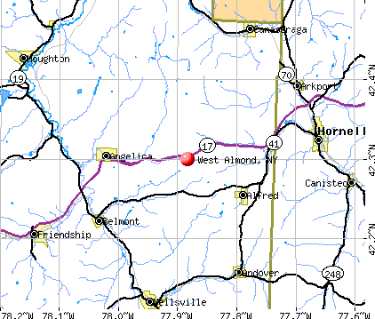
- OSM Map
- General Map
- Google Map
- MSN Map
Population change since 2000: -5.4%
 |
| Males: 179 | |
| Females: 155 |
| Median resident age: | 45.7 years |
| New York median age: | 40.7 years |
Zip codes: 14804.
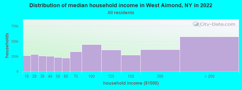
| West Almond: | $77,107 |
| NY: | $79,557 |
Estimated per capita income in 2022: $33,216 (it was $17,358 in 2000)
West Almond town income, earnings, and wages data
Estimated median house or condo value in 2022: $102,079 (it was $53,900 in 2000)
| West Almond: | $102,079 |
| NY: | $400,400 |
Mean prices in 2022: all housing units: $130,143; detached houses: $133,956; townhouses or other attached units: $933,393; in 2-unit structures: $134,751; in 3-to-4-unit structures: $363,909; in 5-or-more-unit structures: $254,137; mobile homes: $80,414; occupied boats, rvs, vans, etc.: $180,265
Detailed information about poverty and poor residents in West Almond, NY


- 29889.2%White alone
- 123.6%Hispanic
- 103.0%Asian alone
- 103.0%Two or more races
- 41.2%Black alone
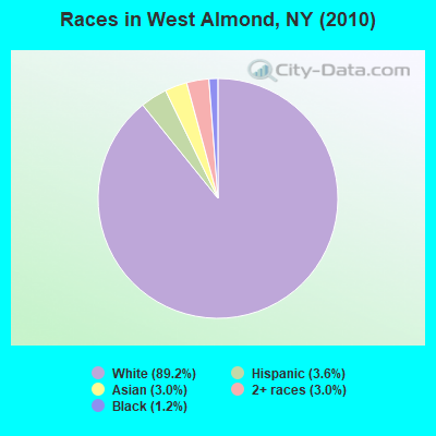
Races in West Almond detailed stats: ancestries, foreign born residents, place of birth
According to our research of New York and other state lists, there was 1 registered sex offender living in West Almond, New York as of May 18, 2024.
The ratio of all residents to sex offenders in West Almond is 334 to 1.
 Recent articles from our blog. Our writers, many of them Ph.D. graduates or candidates, create easy-to-read articles on a wide variety of topics.

Latest news from West Almond, NY collected exclusively by city-data.com from local newspapers, TV, and radio stations
Ancestries: German (23.2%), Irish (16.1%), English (13.6%), United States (7.9%), Italian (4.2%), French (4.0%).
Current Local Time: EST time zone
Elevation: 1857 feet
Land area: 36.0 square miles.
Population density: 9.3 people per square mile (very low).
7 residents are foreign born
| This town: | 2.0% |
| New York: | 20.4% |
| West Almond town: | 1.7% ($943) |
| New York: | 1.9% ($2,847) |
Nearest city with pop. 50,000+: Cheektowaga, NY  (61.1 miles , pop. 79,988).
Nearest city with pop. 200,000+: Rochester, NY (61.1 miles , pop. 219,773).
Nearest city with pop. 1,000,000+: Philadelphia, PA (214.2 miles , pop. 1,517,550).
Nearest cities:
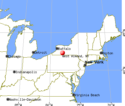
), ), ), ), ), ), )Latitude: 42.31 N, Longitude: 77.89 W

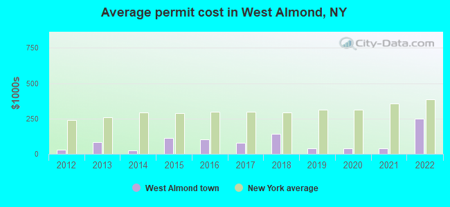
Single-family new house construction building permits:
- 2022: 1 building, cost: $249,000
- 2021: 1 building, cost: $37,000
- 2020: 1 building, cost: $37,000
- 2019: 2 buildings, average cost: $36,500
- 2018: 1 building, cost: $143,600
- 2017: 2 buildings, average cost: $77,300
- 2016: 1 building, cost: $102,000
- 2015: 4 buildings, average cost: $112,900
- 2014: 1 building, cost: $24,400
- 2013: 2 buildings, average cost: $81,500
- 2012: 1 building, cost: $27,600

| Here: | 4.9% |
| New York: | 4.4% |
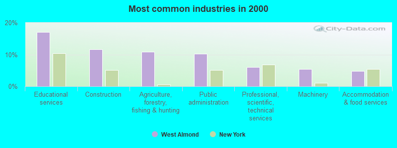
- Educational services (17.0%)
- Construction (11.6%)
- Agriculture, forestry, fishing & hunting (10.9%)
- Public administration (10.2%)
- Professional, scientific, technical services (6.1%)
- Machinery (5.4%)
- Accommodation & food services (4.8%)
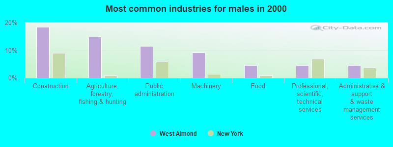
- Construction (18.4%)
- Agriculture, forestry, fishing & hunting (14.9%)
- Public administration (11.5%)
- Machinery (9.2%)
- Food (4.6%)
- Professional, scientific, technical services (4.6%)
- Administrative & support & waste management services (4.6%)
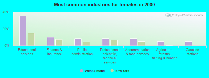
- Educational services (35.0%)
- Finance & insurance (10.0%)
- Public administration (8.3%)
- Professional, scientific, technical services (8.3%)
- Accommodation & food services (8.3%)
- Agriculture, forestry, fishing & hunting (5.0%)
- Gasoline stations (5.0%)
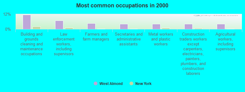
- Building and grounds cleaning and maintenance occupations (11.6%)
- Law enforcement workers, including supervisors (6.8%)
- Farmers and farm managers (4.8%)
- Secretaries and administrative assistants (4.1%)
- Metal workers and plastic workers (4.1%)
- Construction traders workers except carpenters, electricians, painters, plumbers, and construction laborers (4.1%)
- Agricultural workers, including supervisors (4.1%)
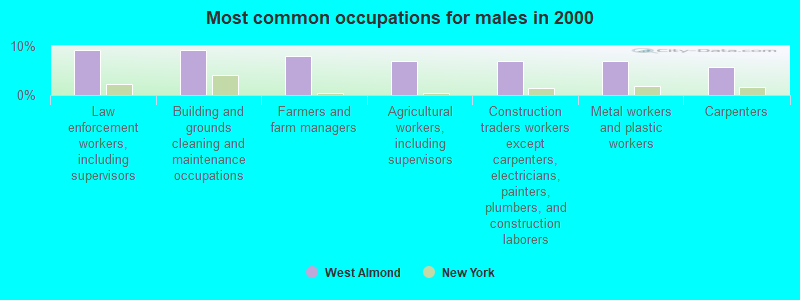
- Law enforcement workers, including supervisors (9.2%)
- Building and grounds cleaning and maintenance occupations (9.2%)
- Farmers and farm managers (8.0%)
- Agricultural workers, including supervisors (6.9%)
- Construction traders workers except carpenters, electricians, painters, plumbers, and construction laborers (6.9%)
- Metal workers and plastic workers (6.9%)
- Carpenters (5.7%)
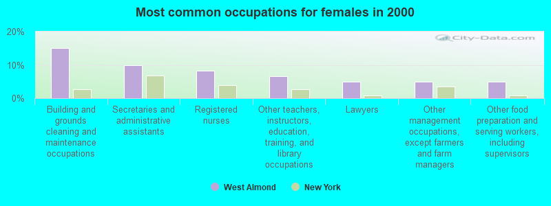
- Building and grounds cleaning and maintenance occupations (15.0%)
- Secretaries and administrative assistants (10.0%)
- Registered nurses (8.3%)
- Other teachers, instructors, education, training, and library occupations (6.7%)
- Lawyers (5.0%)
- Other management occupations, except farmers and farm managers (5.0%)
- Other food preparation and serving workers, including supervisors (5.0%)
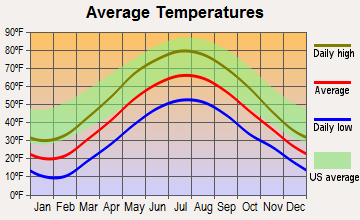
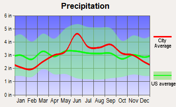
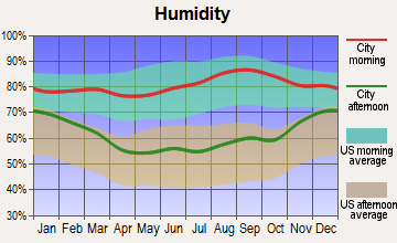
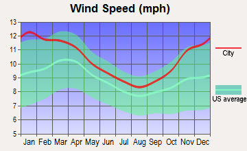
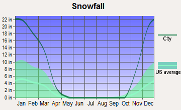
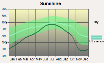
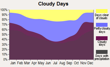
Average climate in West Almond, New York
Based on data reported by over 4,000 weather stations
Tornado activity:
West Almond-area historical tornado activity is near New York state average. It is 63% smaller than the overall U.S. average.
On 6/20/1969, a category F3 (max. wind speeds 158-206 mph) tornado 8.4 miles away from the West Almond town center caused between $500,000 and $5,000,000 in damages.
On 7/21/2003, a category F3 tornado 26.8 miles away from the town center caused $200,000 in damages.
Earthquake activity:
West Almond-area historical earthquake activity is significantly above New York state average. It is 66% smaller than the overall U.S. average.On 9/25/1998 at 19:52:52, a magnitude 5.2 (4.8 MB, 4.3 MS, 5.2 LG, 4.5 MW, Depth: 3.1 mi, Class: Moderate, Intensity: VI - VII) earthquake occurred 140.9 miles away from West Almond center
On 8/23/2011 at 17:51:04, a magnitude 5.8 (5.8 MW, Depth: 3.7 mi) earthquake occurred 304.1 miles away from West Almond center
On 10/7/1983 at 10:18:46, a magnitude 5.3 (5.1 MB, 5.3 LG, 5.1 ML) earthquake occurred 212.2 miles away from West Almond center
On 1/31/1986 at 16:46:43, a magnitude 5.0 (5.0 MB) earthquake occurred 175.2 miles away from the city center
On 4/20/2002 at 10:50:47, a magnitude 5.3 (5.3 ML, Depth: 3.0 mi) earthquake occurred 260.0 miles away from West Almond center
On 4/20/2002 at 10:50:47, a magnitude 5.2 (5.2 MB, 4.2 MS, 5.2 MW, 5.0 MW) earthquake occurred 258.2 miles away from West Almond center
Magnitude types: regional Lg-wave magnitude (LG), body-wave magnitude (MB), local magnitude (ML), surface-wave magnitude (MS), moment magnitude (MW)
Natural disasters:
The number of natural disasters in Allegany County (21) is greater than the US average (15).Major Disasters (Presidential) Declared: 16
Emergencies Declared: 5
Causes of natural disasters: Storms: 14, Floods: 12, Hurricanes: 2, Tornadoes: 2, Blizzard: 1, Heavy Rain: 1, Landslide: 1, Power Outage: 1, Tropical Storm: 1, Wind: 1, Winter Storm: 1, Other: 2 (Note: some incidents may be assigned to more than one category).
Hospitals and medical centers near West Almond:
- ST JAMES MERCY HOSPITAL Acute Care Hospitals (about 12 miles away; HORNELL, NY)
- ST. JAMES MERCY HOSPITAL (Dialysis Facility, about 12 miles away; HORNELL, NY)
- HORNELL GARDENS (Nursing Home, about 12 miles away; HORNELL, NY)
- WELLSVILLE MANOR NH (Nursing Home, about 13 miles away; WELLSVILLE, NY)
- JONES MEMORIAL HOSPITAL Acute Care Hospitals (about 14 miles away; WELLSVILLE, NY)
- HIGHLAND PARK REHABILITATION AND NURSING CENTER (Nursing Home, about 14 miles away; WELLSVILLE, NY)
Colleges/universities with over 2000 students nearest to West Almond:
- SUNY College of Technology at Alfred (about 6 miles; Alfred, NY; Full-time enrollment: 3,483)
- Alfred University (about 7 miles; Alfred, NY; FT enrollment: 2,411)
- St Bonaventure University (about 34 miles; Saint Bonaventure, NY; FT enrollment: 2,286)
- SUNY College at Geneseo (about 35 miles; Geneseo, NY; FT enrollment: 5,520)
- Corning Community College (about 44 miles; Corning, NY; FT enrollment: 3,036)
- Genesee Community College (about 51 miles; Batavia, NY; FT enrollment: 4,290)
- Finger Lakes Community College (about 51 miles; Canandaigua, NY; FT enrollment: 4,732)
Points of interest:
Notable location: Bainbridge Family Farm (A). Display/hide its location on the map
Cemetery: West Almond Cemetery (1). Display/hide its location on the map
Lake: Palmers Pond (A). Display/hide its location on the map
Creek: California Creek (A). Display/hide its location on the map
| This town: | 2.5 people |
| New York: | 2.6 people |
| This town: | 66.2% |
| Whole state: | 63.5% |
| This town: | 8.1% |
| Whole state: | 6.8% |
No gay or lesbian households reported
| This town: | 6.6% |
| Whole state: | 14.6% |
| This town: | 3.6% |
| Whole state: | 7.4% |
For population 15 years and over in West Almond:
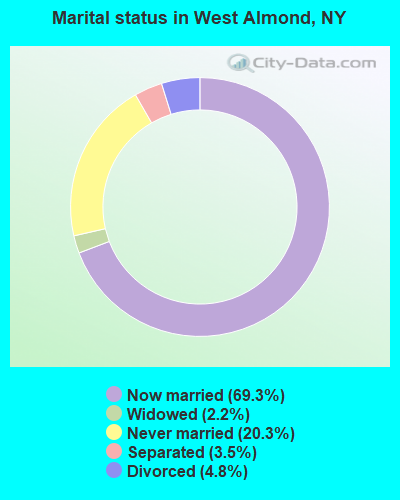
- Never married: 20.3%
- Now married: 69.3%
- Separated: 3.5%
- Widowed: 2.2%
- Divorced: 4.8%
For population 25 years and over in West Almond:
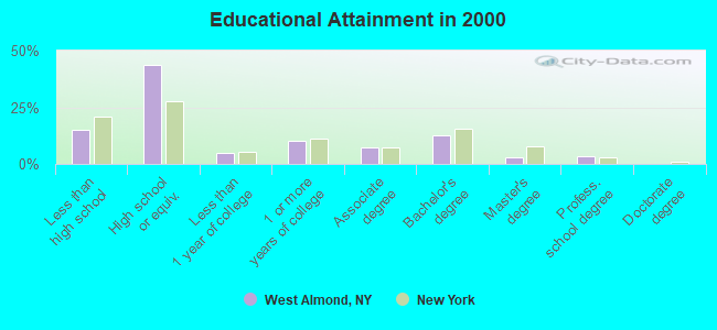
- High school or higher: 85.0%
- Bachelor's degree or higher: 18.7%
- Graduate or professional degree: 6.1%
- Unemployed: 4.5%
- Mean travel time to work (commute): 26.5 minutes
| Here: | 11.0 |
| New York average: | 14.2 |
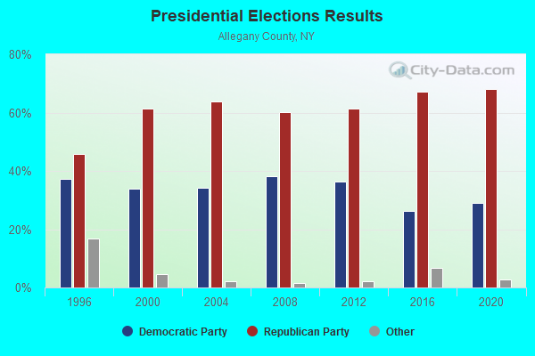
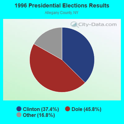
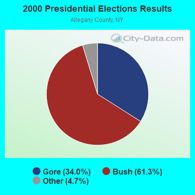
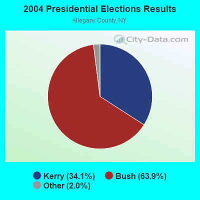
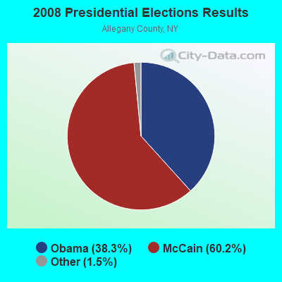
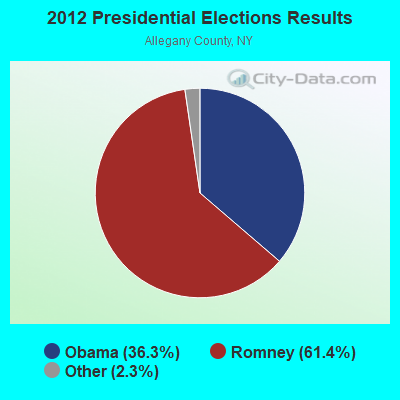
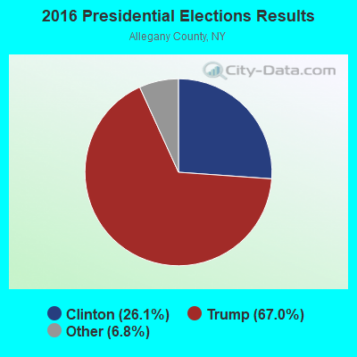
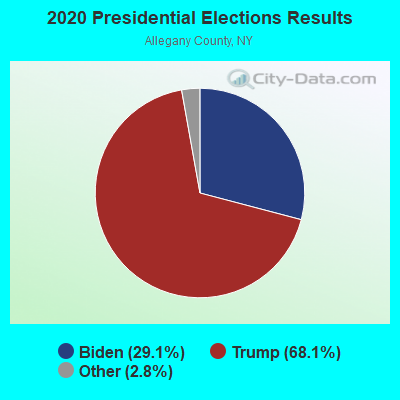
Graphs represent county-level data. Detailed 2008 Election Results
Religion statistics for West Almond, NY (based on Allegany County data)
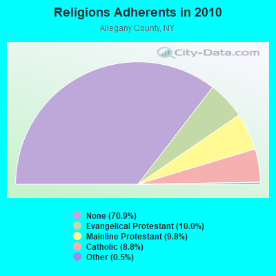
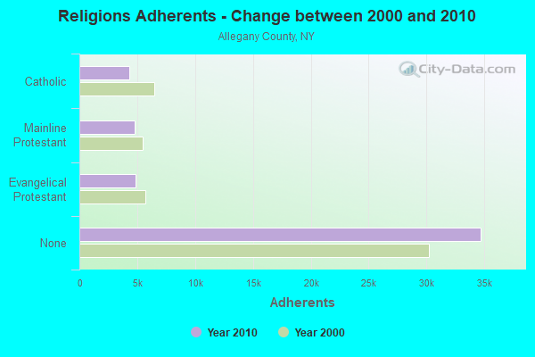
| Religion | Adherents | Congregations |
|---|---|---|
| Evangelical Protestant | 4,881 | 46 |
| Mainline Protestant | 4,798 | 39 |
| Catholic | 4,313 | 10 |
| Other | 244 | 4 |
| None | 34,710 | - |
Food Environment Statistics:
| This county: | 3.03 / 10,000 pop. |
| New York: | 4.13 / 10,000 pop. |
| Here: | 0.40 / 10,000 pop. |
| State: | 0.92 / 10,000 pop. |
| Allegany County: | 5.25 / 10,000 pop. |
| New York: | 1.68 / 10,000 pop. |
| Allegany County: | 8.48 / 10,000 pop. |
| State: | 8.82 / 10,000 pop. |
| Allegany County: | 8.8% |
| State: | 8.2% |
| This county: | 25.6% |
| State: | 23.8% |
| Allegany County: | 11.5% |
| New York: | 15.6% |
Strongest AM radio stations in West Almond:
- WHHO (1320 AM; 5 kW; HORNELL, NY; Owner: BILBAT RADIO, INC.)
- WHAM (1180 AM; 50 kW; ROCHESTER, NY; Owner: CITICASTERS LICENSES, L.P.)
- WLEA (1480 AM; 2 kW; HORNELL, NY; Owner: PMJ COMMUNICATIONS, INC.)
- WWKB (1520 AM; 50 kW; BUFFALO, NY; Owner: ENTERCOM BUFFALO LICENSE, LLC)
- WABH (1380 AM; 10 kW; BATH, NY)
- WLSV (790 AM; 1 kW; WELLSVILLE, NY; Owner: DBM COMMUNICATIONS, INC.)
- WGR (550 AM; 5 kW; BUFFALO, NY; Owner: ENTERCOM BUFFALO LICENSE, LLC)
- WCJW (1140 AM; daytime; 2 kW; WARSAW, NY; Owner: LLOYD LANE, INCORPORATED)
- WWJZ (640 AM; 50 kW; MOUNT HOLLY, NJ; Owner: ABC, INC.)
- WDNY (1400 AM; 1 kW; DANSVILLE, NY; Owner: MILLER MEDIA INC)
- KDKA (1020 AM; 50 kW; PITTSBURGH, PA; Owner: INFINITY BROADCASTING OPERATIONS, INC.)
- WGGO (1590 AM; 5 kW; SALAMANCA, NY; Owner: CATT COMMUNICATIONS, INC.)
- WLNL (1000 AM; daytime; 5 kW; HORSEHEADS, NY; Owner: LIGHTHOUSE MEDIA, INC.)
Strongest FM radio stations in West Almond:
- WZKZ (101.9 FM; ALFRED, NY; Owner: PEMBROOK PINES ELMIRA, LTD.)
- WETD (90.7 FM; ALFRED, NY; Owner: STATE UNIVERSITY OF NEW YORK)
- WKPQ (105.3 FM; HORNELL, NY; Owner: BILBAT RADIO, INC.)
- WCKR (92.1 FM; HORNELL, NY; Owner: PMJ COMMUNICATIONS, INC.)
- WSQA (88.7 FM; HORNELL, NY; Owner: WSKG PUBLIC TELECOMMUNICATIONS COUNCIL)
- W257AX (99.3 FM; HORNELL, NY; Owner: FAMILY LIFE MINISTRIES, INC.)
- WDNY-FM (93.9 FM; DANSVILLE, NY; Owner: MILLER MEDIA INC.)
- WJQZ (103.5 FM; WELLSVILLE, NY; Owner: DBM COMMUNICATIONS, INC.)
- W201CY (88.1 FM; DANSVILLE, NY; Owner: MARS HILL BROADCASTING CO., INC.)
- W246AP (97.1 FM; DANSVILLE, NY; Owner: CALVARY CHAPEL OF THE FINGER LAKES)
- W282AC (104.3 FM; DANSVILLE, NY; Owner: FAMILY LIFE MINISTRIES, INC.)
- WCID (89.1 FM; FRIENDSHIP, NY; Owner: FAMILY LIFE MINISTRIES, INC.)
- WNSA (107.7 FM; WETHERSFIELD TWNSHP, NY; Owner: ADELPHIA COMMUNICATIONS CORPORATION, DEBTOR-IN-POSSESSION)
- WCIK (103.1 FM; BATH, NY; Owner: FAMILY LIFE MINISTRIES, INC.)
- WTSS (102.5 FM; BUFFALO, NY; Owner: ENTERCOM BUFFALO LICENSE, LLC)
- WCIY (88.9 FM; CANANDAIGUA, NY; Owner: FAMILY LIFE MINISTRIES, INC.)
- WFXF (107.3 FM; SOUTH BRISTOL TOWNSH, NY; Owner: CITICASTERS LICENSES, L.P.)
- WNVE (95.1 FM; HONEOYE FALLS, NY; Owner: CITICASTERS LICENSES, L.P.)
- WPIG (95.7 FM; OLEAN, NY; Owner: ARROW COMMUNICATIONS OF N.Y., INC.)
- WOLN (91.3 FM; OLEAN, NY; Owner: STATE UNIVERSITY OF NEW YORK)
TV broadcast stations around West Almond:
- WKBW-TV (Channel 7; BUFFALO, NY; Owner: WKBW-TV LICENSE, INC.)
- W16BE (Channel 16; HORNELL, NY; Owner: WYDC, INC.)
- WNGS (Channel 67; SPRINGVILLE, NY; Owner: CAROLINE K. POWLEY D/B/A UNICORN/SPRINGVILLE)
- WPXJ-TV (Channel 51; BATAVIA, NY; Owner: PAXSON BUFFALO LICENSE, INC.)
- WNYO-TV (Channel 49; BUFFALO, NY; Owner: NEW YORK TELEVISION, INC.)
- WIVB-TV (Channel 4; BUFFALO, NY; Owner: WIVB BROADCASTING, LLC)
- National Bridge Inventory (NBI) Statistics
- 15Number of bridges
- 69ft / 21.3mTotal length
- $16,010,000Total costs
- 11,980Total average daily traffic
- 3,931Total average daily truck traffic
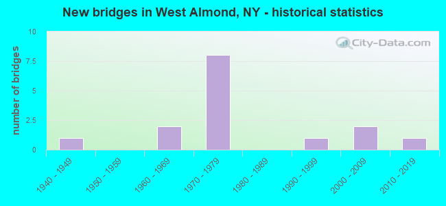
- New bridges - historical statistics
- 11940-1949
- 21960-1969
- 81970-1979
- 11990-1999
- 22000-2009
- 12010-2019
FCC Registered Antenna Towers:
11 (See the full list of FCC Registered Antenna Towers in West Almond)FCC Registered Microwave Towers:
1- West Almond, 2432 County Road 2 (Lat: 42.311278 Lon: -77.868694), Type: Mast, Structure height: 91.4 m, Overall height: 95.1 m, Call Sign: WQHP909,
Assigned Frequencies: 11215.0 MHz, 11255.0 MHz, 11265.0 MHz, Grant Date: 10/02/2007, Expiration Date: 10/02/2017, Cancellation Date: 02/26/2014, Certifier: Pamelia Y Hoof, Registrant: Verizon Wireless, 1120 Sanctuary Pkwy, #150 Gasa5reg, Alpharetta, GA 30009-7630, Phone: (770) 797-1070, Fax: (770) 797-1036, Email:
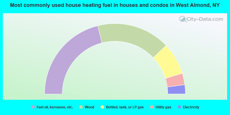
- 42.1%Fuel oil, kerosene, etc.
- 33.7%Wood
- 14.7%Bottled, tank, or LP gas
- 5.3%Utility gas
- 4.2%Electricity
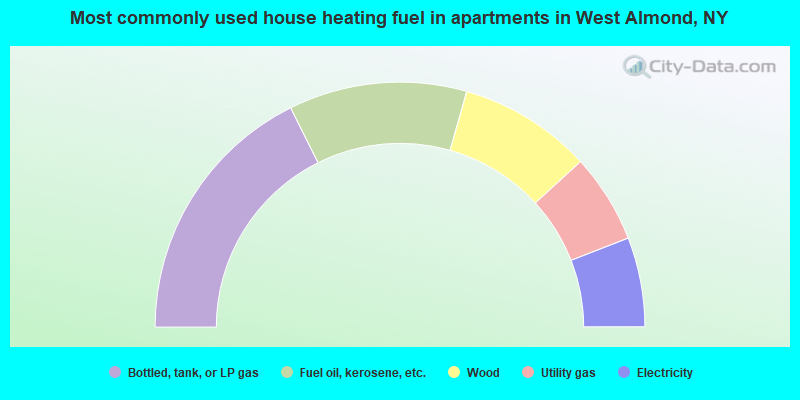
- 35.3%Bottled, tank, or LP gas
- 23.5%Fuel oil, kerosene, etc.
- 17.6%Wood
- 11.8%Utility gas
- 11.8%Electricity
West Almond compared to New York state average:
- Median house value significantly below state average.
- Unemployed percentage significantly below state average.
- Black race population percentage significantly below state average.
- Hispanic race population percentage significantly below state average.
- Median age above state average.
- Foreign-born population percentage significantly below state average.
- Renting percentage significantly below state average.
- Length of stay since moving in significantly above state average.
- Number of rooms per house significantly below state average.
- House age significantly below state average.
- Number of college students significantly below state average.
- Percentage of population with a bachelor's degree or higher below state average.