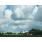
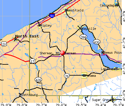
Sherman, New York
Submit your own pictures of this village and show them to the world
- OSM Map
- General Map
- Google Map
- MSN Map
Population change since 2000: -5.2%
 |
| Males: 340 | |
| Females: 337 |
| Median resident age: | 40.2 years |
| New York median age: | 40.0 years |
Zip codes: 14781.
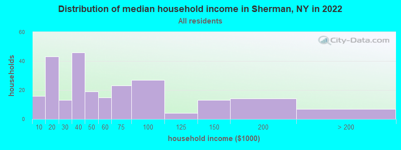
| Sherman: | $40,065 |
| NY: | $79,557 |
Estimated per capita income in 2022: $29,328 (it was $15,266 in 2000)
Sherman village income, earnings, and wages data
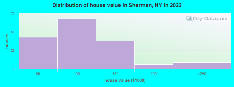
Estimated median house or condo value in 2022: $91,129 (it was $46,900 in 2000)
| Sherman: | $91,129 |
| NY: | $400,400 |
Mean prices in 2022: all housing units: $81,648; detached houses: $79,730; in 2-unit structures: $67,293
Median gross rent in 2022: $564.
(22.1% for White Non-Hispanic residents, 100.0% for American Indian residents)
Detailed information about poverty and poor residents in Sherman, NY
Compare current foreclosures near Sherman, NY:
| Photo | Address | Area | Beds / Baths | Price | Details |
|---|---|---|---|---|---|

|
#1
Kidder Rd
Sherman, NY 14781
|
- sq. feet
|
- baths - beds |
show details | |

|
#2
Mead Ave
Corry, PA 16407
|
1,272 sq. feet
|
2 baths 3 beds |
$19,900
|
show details |

|
#3
E Chautauqua St
Mayville, NY 14757
|
2,012 sq. feet
|
2 baths 4 beds |
show details | |

|
#4
Robinson St
North East, PA 16428
|
1,664 sq. feet
|
1 baths 3 beds |
show details | |

|
#5
Robinson St
North East, PA 16428
|
2,778 sq. feet
|
2 baths 4 beds |
show details | |

|
#6
Clinton St
North East, PA 16428
|
1,528 sq. feet
|
1 baths 3 beds |
show details | |

|
#7
Clinton St
North East, PA 16428
|
1,528 sq. feet
|
1 baths 3 beds |
show details | |

|
#8
Baker St
Lakewood, NY 14750
|
2,198 sq. feet
|
2 baths 3 beds |
show details | |

|
#9
Mead Ave
Corry, PA 16407
|
2,358 sq. feet
|
1 baths 3 beds |
show details | |

|
#10
W Bond St
Corry, PA 16407
|
1,129 sq. feet
|
1 baths 2 beds |
show details |
| Photo | Address | Area | Beds / Baths | Price | Details |
|---|---|---|---|---|---|

|
#11
Sidehill Rd
North East, PA 16428
|
1,878 sq. feet
|
2 baths 4 beds |
show details | |

|
#12
Wayne St
Corry, PA 16407
|
1,156 sq. feet
|
1 baths 2 beds |
show details | |

|
#13
Worth St
Corry, PA 16407
|
1,200 sq. feet
|
1 baths 3 beds |
show details | |

|
#14
Woleben Rd
Portland, NY 14769
|
1,904 sq. feet
|
1 baths 4 beds |
show details | |

|
#15
Briarwood Dr
Lakewood, NY 14750
|
3,356 sq. feet
|
5 baths 4 beds |
show details | |

|
#16
Creek Rd
Wattsburg, PA 16442
|
2,072 sq. feet
|
1 baths 3 beds |
show details | |

|
#17
W Division St
North East, PA 16428
|
1,586 sq. feet
|
1 baths 3 beds |
show details | |

|
#18
Mead Ave
Corry, PA 16407
|
2,906 sq. feet
|
1 baths 2 beds |
show details | |

|
#19
Cowing Rd
Lakewood, NY 14750
|
1,232 sq. feet
|
1 baths 2 beds |
show details | |

|
#20
Pershing Ave
North East, PA 16428
|
1,942 sq. feet
|
1 baths 4 beds |
show details |
| Photo | Address | Area | Beds / Baths | Price | Details |
|---|---|---|---|---|---|

|
#21
Ashton Rd
North East, PA 16428
|
1,464 sq. feet
|
1 baths 3 beds |
show details | |

|
#22
Grand St
Corry, PA 16407
|
1,242 sq. feet
|
1 baths 3 beds |
show details | |

|
#23
Mohawk St
Clymer, NY 14724
|
1,594 sq. feet
|
2 baths 4 beds |
show details | |

|
#24
Kerr Rd
North East, PA 16428
|
1,785 sq. feet
|
1 baths 3 beds |
show details | |

|
#25
Rich Hill Rd
North East, PA 16428
|
1,957 sq. feet
|
1 baths 4 beds |
show details | |

|
#26
W Smith St
Corry, PA 16407
|
1,362 sq. feet
|
1 baths 4 beds |
show details | |

|
#27
Macedonia Rd
Wattsburg, PA 16442
|
1,264 sq. feet
|
1 baths 3 beds |
show details | |

|
#28
Cass St
Westfield, NY 14787
|
2,706 sq. feet
|
3 baths 4 beds |
show details | |

|
#29
W Smith St
Corry, PA 16407
|
1,394 sq. feet
|
1 baths 3 beds |
show details | |

|
#30
E Main St
North East, PA 16428
|
1,184 sq. feet
|
1 baths 3 beds |
show details |
| Photo | Address | Area | Beds / Baths | Price | Details |
|---|---|---|---|---|---|

|
#31
S Washington St
North East, PA 16428
|
1,620 sq. feet
|
1 baths 3 beds |
show details | |

|
#32
W Smith St
Corry, PA 16407
|
- sq. feet
|
- baths - beds |
show details | |

|
#33
Cemetery Rd
Portland, NY 14769
|
- sq. feet
|
- baths - beds |
show details | |

|
#34
Concord St
Corry, PA 16407
|
- sq. feet
|
- baths - beds |
show details | |

|
#35
Hillview Dr
Lakewood, NY 14750
|
- sq. feet
|
- baths - beds |
show details | |

|
#36
Dutch Hollow Rd
Bemus Point, NY 14712
|
- sq. feet
|
- baths - beds |
show details | |

|
#37
Knoyle Rd
Wattsburg, PA 16442
|
- sq. feet
|
- baths - beds |
show details | |

|
#38
Sunshine Ln Lot 27
Wattsburg, PA 16442
|
938 sq. feet
|
- baths - beds |
show details | |

|
#39
E Terrace Ave
Lakewood, NY 14750
|
- sq. feet
|
- baths - beds |
show details | |

|
#40
Page Rd
Wattsburg, PA 16442
|
924 sq. feet
|
- baths - beds |
show details |
| Photo | Address | Area | Beds / Baths | Price | Details |
|---|---|---|---|---|---|

|
#41
Hoag Rd
Panama, NY 14767
|
- sq. feet
|
- baths - beds |
show details | |

|
#42
Green St
Lakewood, NY 14750
|
- sq. feet
|
- baths - beds |
show details | |

|
#43
Ashville Rd
Ashville, NY 14710
|
- sq. feet
|
- baths - beds |
show details | |

|
#44
S Washington St Apt B3
North East, PA 16428
|
- sq. feet
|
- baths - beds |
show details | |

|
#45
E Route 20 Trlr 20
Westfield, NY 14787
|
- sq. feet
|
- baths - beds |
show details | |

|
#46
Blockville Watts Flats Rd
Ashville, NY 14710
|
720 sq. feet
|
- baths - beds |
show details | |

|
#47
S Washington St
North East, PA 16428
|
- sq. feet
|
- baths - beds |
show details | |

|
#48
Jefferson St
Westfield, NY 14787
|
- sq. feet
|
- baths - beds |
show details | |

|
#49
Sandy Ln
Ripley, NY 14775
|
- sq. feet
|
- baths - beds |
show details | |

|
Check over 1 million property listings on Foreclosure.com!
|
browse all offers | |||


- 51592.0%White alone
- 162.9%American Indian alone
- 132.3%Two or more races
- 91.6%Other race alone
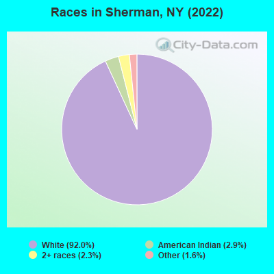
Races in Sherman detailed stats: ancestries, foreign born residents, place of birth
According to our research of New York and other state lists, there were 5 registered sex offenders living in Sherman, New York as of May 18, 2024.
The ratio of all residents to sex offenders in Sherman is 139 to 1.
 Recent articles from our blog. Our writers, many of them Ph.D. graduates or candidates, create easy-to-read articles on a wide variety of topics.

 | Buyer Beware - Ithaca NY (64 replies) |
| Glens Falls development... (118 replies) |
| Indoor Mask mandate and NY Big Banks return (55 replies) |
| An Interesting Read on Why the Bronx Declined in the 1970s (65 replies) |
| smaller Upstate NY cities and towns/African American communities (5986 replies) |
| Neighborhood revitalization/gentrification (186 replies) |
Latest news from Sherman, NY collected exclusively by city-data.com from local newspapers, TV, and radio stations
Ancestries: English (30.8%), German (19.4%), Irish (9.5%), Swedish (9.5%), Dutch (5.9%), European (4.7%).
Current Local Time: EST time zone
Incorporated in 1890
Elevation: 1539 feet
Land area: 0.83 square miles.
Population density: 816 people per square mile (low).
9 residents are foreign born
| This village: | 1.3% |
| New York: | 20.4% |
Median real estate property taxes paid for housing units with mortgages in 2022: $1,820 (1.7%)
Median real estate property taxes paid for housing units with no mortgage in 2022: $2,242 (2.7%)
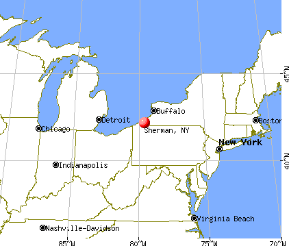
Nearest city with pop. 50,000+: Erie, PA  (24.9 miles , pop. 103,717).
Nearest city with pop. 200,000+: Buffalo, NY (64.0 miles , pop. 292,648).
Nearest city with pop. 1,000,000+: Philadelphia, PA (276.0 miles , pop. 1,517,550).
Nearest cities:
), Latitude: 42.16 N, Longitude: 79.59 W
Area code: 716

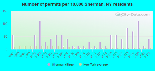
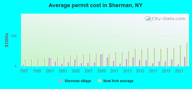
Single-family new house construction building permits:
- 2022: 3 buildings, average cost: $160,000
- 2021: 1 building, cost: $40,000
- 2020: 8 buildings, average cost: $119,400
- 2019: 5 buildings, average cost: $83,600
- 2018: 6 buildings, average cost: $81,700
- 2017: 3 buildings, average cost: $53,300
- 2016: 4 buildings, average cost: $102,500
- 2015: 4 buildings, average cost: $114,000
- 2014: 1 building, cost: $150,000
- 2013: 2 buildings, average cost: $125,000
- 2012: 1 building, cost: $50,000
- 2011: 2 buildings, average cost: $95,000
- 2010: 1 building, cost: $150,000
- 2009: 1 building, cost: $200,000
- 2008: 1 building, cost: $70,000
- 2007: 3 buildings, average cost: $60,000
- 2006: 4 buildings, average cost: $60,000
- 2005: 4 buildings, average cost: $116,300
- 2004: 3 buildings, average cost: $71,700
- 2003: 2 buildings, average cost: $50,000
- 2002: 8 buildings, average cost: $81,100
- 2001: 4 buildings, average cost: $139,700
- 1997: 4 buildings, average cost: $33,500
| Here: | 4.8% |
| New York: | 4.4% |
- Educational services (16.8%)
- Accommodation & food services (12.3%)
- Construction (6.6%)
- Food & beverage stores (6.3%)
- Health care (5.7%)
- Public administration (5.1%)
- Arts, entertainment, recreation (5.1%)
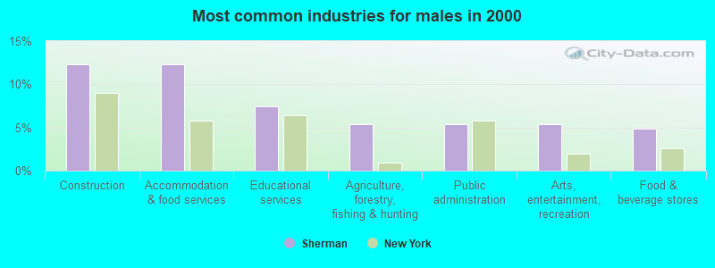
- Construction (12.3%)
- Accommodation & food services (12.3%)
- Educational services (7.5%)
- Agriculture, forestry, fishing & hunting (5.3%)
- Public administration (5.3%)
- Arts, entertainment, recreation (5.3%)
- Food & beverage stores (4.8%)
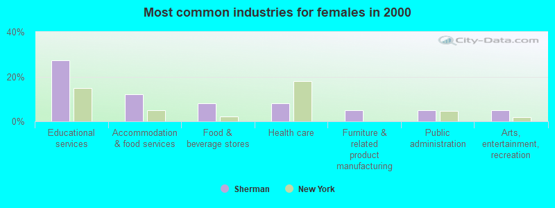
- Educational services (27.4%)
- Accommodation & food services (12.2%)
- Food & beverage stores (7.9%)
- Health care (7.9%)
- Furniture & related product manufacturing (4.9%)
- Public administration (4.9%)
- Arts, entertainment, recreation (4.9%)
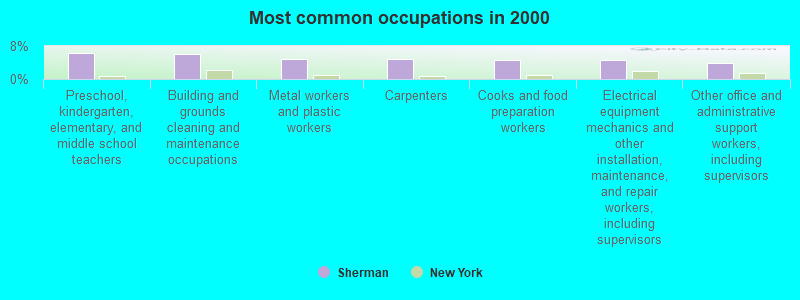
- Preschool, kindergarten, elementary, and middle school teachers (6.3%)
- Building and grounds cleaning and maintenance occupations (6.0%)
- Metal workers and plastic workers (4.8%)
- Carpenters (4.8%)
- Cooks and food preparation workers (4.6%)
- Electrical equipment mechanics and other installation, maintenance, and repair workers, including supervisors (4.6%)
- Other office and administrative support workers, including supervisors (4.0%)
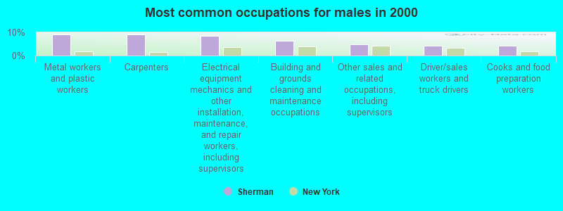
- Metal workers and plastic workers (9.1%)
- Carpenters (9.1%)
- Electrical equipment mechanics and other installation, maintenance, and repair workers, including supervisors (8.6%)
- Building and grounds cleaning and maintenance occupations (6.4%)
- Other sales and related occupations, including supervisors (4.8%)
- Driver/sales workers and truck drivers (4.3%)
- Cooks and food preparation workers (4.3%)
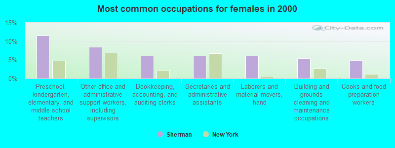
- Preschool, kindergarten, elementary, and middle school teachers (11.6%)
- Other office and administrative support workers, including supervisors (8.5%)
- Bookkeeping, accounting, and auditing clerks (6.1%)
- Secretaries and administrative assistants (6.1%)
- Laborers and material movers, hand (6.1%)
- Building and grounds cleaning and maintenance occupations (5.5%)
- Cooks and food preparation workers (4.9%)
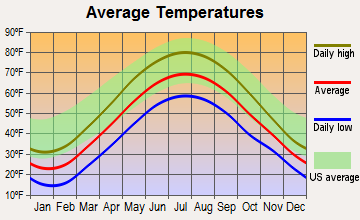
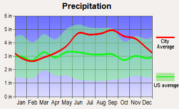
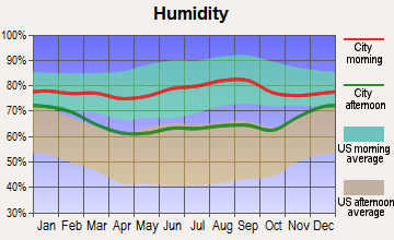
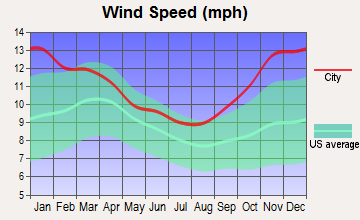
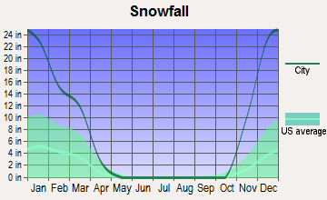
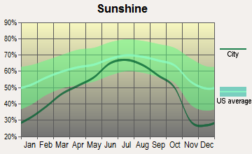
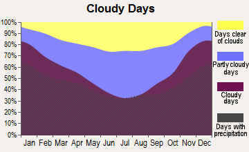
Average climate in Sherman, New York
Based on data reported by over 4,000 weather stations
(lower is better)
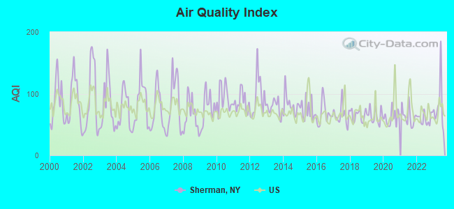
Air Quality Index (AQI) level in 2023 was 81.2. This is about average.
| City: | 81.2 |
| U.S.: | 72.6 |
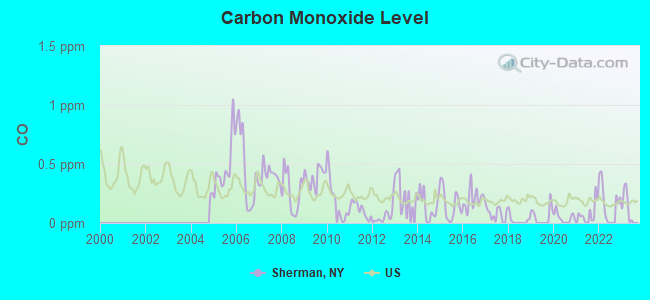
Carbon Monoxide (CO) [ppm] level in 2023 was 0.120. This is significantly better than average. Closest monitor was 22.8 miles away from the city center.
| City: | 0.120 |
| U.S.: | 0.251 |

Nitrogen Dioxide (NO2) [ppb] level in 2023 was 5.31. This is about average. Closest monitor was 19.6 miles away from the city center.
| City: | 5.31 |
| U.S.: | 5.11 |
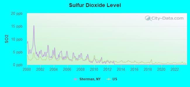
Sulfur Dioxide (SO2) [ppb] level in 2012 was 0.972. This is significantly better than average. Closest monitor was 9.0 miles away from the city center.
| City: | 0.972 |
| U.S.: | 1.515 |
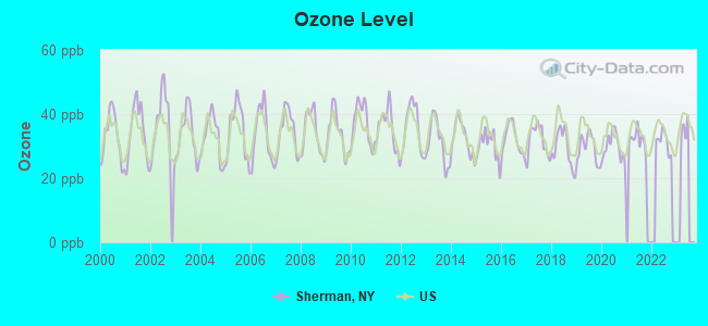
Ozone [ppb] level in 2022 was 31.5. This is about average. Closest monitor was 9.0 miles away from the city center.
| City: | 31.5 |
| U.S.: | 33.3 |
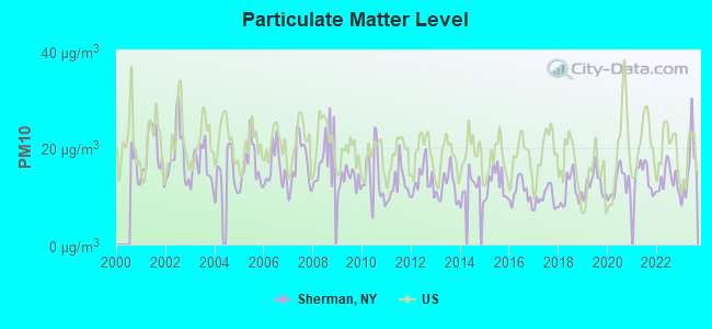
Particulate Matter (PM10) [µg/m3] level in 2023 was 15.9. This is better than average. Closest monitor was 9.0 miles away from the city center.
| City: | 15.9 |
| U.S.: | 19.2 |
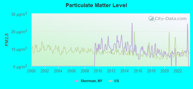
Particulate Matter (PM2.5) [µg/m3] level in 2023 was 11.1. This is worse than average. Closest monitor was 9.0 miles away from the city center.
| City: | 11.1 |
| U.S.: | 8.1 |
Tornado activity:
Sherman-area historical tornado activity is above New York state average. It is 40% smaller than the overall U.S. average.
On 5/31/1985, a category F4 (max. wind speeds 207-260 mph) tornado 11.4 miles away from the Sherman village center .
On 5/2/1983, a category F3 (max. wind speeds 158-206 mph) tornado 1.5 miles away from the village center killed 2 people and caused between $500,000 and $5,000,000 in damages.
Earthquake activity:
Sherman-area historical earthquake activity is significantly above New York state average. It is 64% smaller than the overall U.S. average.On 9/25/1998 at 19:52:52, a magnitude 5.2 (4.8 MB, 4.3 MS, 5.2 LG, 4.5 MW, Depth: 3.1 mi, Class: Moderate, Intensity: VI - VII) earthquake occurred 62.0 miles away from the city center
On 1/31/1986 at 16:46:43, a magnitude 5.0 (5.0 MB) earthquake occurred 89.4 miles away from the city center
On 8/23/2011 at 17:51:04, a magnitude 5.8 (5.8 MW, Depth: 3.7 mi) earthquake occurred 306.8 miles away from the city center
On 10/7/1983 at 10:18:46, a magnitude 5.3 (5.1 MB, 5.3 LG, 5.1 ML) earthquake occurred 292.9 miles away from the city center
On 1/26/2001 at 03:03:20, a magnitude 3.9 (3.9 MB, Depth: 3.1 mi, Class: Light, Intensity: II - III) earthquake occurred 63.8 miles away from the city center
On 12/31/2011 at 20:05:01, a magnitude 4.0 (4.0 ML, Depth: 3.1 mi, Class: Light, Intensity: IV - V) earthquake occurred 91.3 miles away from Sherman center
Magnitude types: regional Lg-wave magnitude (LG), body-wave magnitude (MB), local magnitude (ML), surface-wave magnitude (MS), moment magnitude (MW)
Natural disasters:
The number of natural disasters in Chautauqua County (21) is greater than the US average (15).Major Disasters (Presidential) Declared: 11
Emergencies Declared: 9
Causes of natural disasters: Floods: 9, Storms: 9, Snowstorms: 4, Hurricanes: 2, Winter Storms: 2, Blizzard: 1, Ice Storm: 1, Power Outage: 1, Snow: 1, Tropical Storm: 1, Wind: 1, Other: 2 (Note: some incidents may be assigned to more than one category).

Hospitals and medical centers near Sherman:
- HOSPICE CHAUTAUQUA COUNTY INC (Hospital, about 8 miles away; MAYVILLE, NY)
- ABSOLUT CTR FOR NURSING AND REHAB WESTFIELD L L C (Nursing Home, about 12 miles away; WESTFIELD, NY)
- COMMUNITY NURSING NORTH EAST (Home Health Center, about 13 miles away; NORTH EAST, PA)
- WESTFIELD MEMORIAL HOSPITAL, INC Acute Care Hospitals (about 14 miles away; WESTFIELD, NY)
- CORRY REGIONAL HOSPICE (Hospital, about 16 miles away; CORRY, PA)
Airports located in Sherman:
- Pratt's Eastern Divide Airport (D88) (Runways: 1, Itinerant Ops: 100, Local Ops: 100)
Colleges/universities with over 2000 students nearest to Sherman:
- Jamestown Community College (about 20 miles; Jamestown, NY; Full-time enrollment: 3,384)
- Pennsylvania State University-Penn State Erie-Behrend College (about 21 miles; Erie, PA; FT enrollment: 4,025)
- Mercyhurst University (about 24 miles; Erie, PA; FT enrollment: 2,888)
- SUNY at Fredonia (about 25 miles; Fredonia, NY; FT enrollment: 5,523)
- Gannon University (about 26 miles; Erie, PA; FT enrollment: 3,760)
- Edinboro University of Pennsylvania (about 34 miles; Edinboro, PA; FT enrollment: 6,746)
- Allegheny College (about 46 miles; Meadville, PA; FT enrollment: 2,249)
Public high school in Sherman:
- SHERMAN HIGH SCHOOL (Students: 230, Location: 127 PARK ST, Grades: 7-12)
Public elementary/middle school in Sherman:
- SHERMAN ELEMENTARY SCHOOL (Students: 250, Location: 127 PARK ST, Grades: PK-6)
Private elementary/middle schools in Sherman:
- CLEAR VIEW SCHOOL (Students: 44, Location: 3170 ROUTE 76, Grades: 1-8)
- VALLEY VIEW AMISH SCHOOL (Students: 22, Location: 2384 CLYMER SHERMAN RD, Grades: 1-8)
Points of interest:
Notable locations in Sherman: Minerva Free Library (A), Sherman Fire Department (B), Main Street Theatre (C), Village of Sherman Garage (D). Display/hide their locations on the map
Churches in Sherman include: Saint Isaac Jogues Church (A), Sherman Community Church (B), First Baptist Church (C), Abundant Life Seventh Day Adventist Church (D), Sherman Assembly of God Church (E). Display/hide their locations on the map
Drinking water stations with addresses in Sherman that have no violations reported:
- PINE JUNCTION (Population served: 30, Primary Water Source Type: Groundwater)
- SALE BARN DINER (Population served: 25, Primary Water Source Type: Groundwater)
| This village: | 2.6 people |
| New York: | 2.6 people |
| This village: | 67.4% |
| Whole state: | 63.5% |
| This village: | 5.7% |
| Whole state: | 6.8% |
Likely homosexual households (counted as self-reported same-sex unmarried-partner households)
- Lesbian couples: 0.7% of all households
- Gay men: 0.0% of all households
Banks with branches in Sherman (2011 data):
- Community Bank, National Association: Sherman Branch at 101 Main Street, branch established on 1946/04/11. Info updated 2011/06/13: Bank assets: $6,460.6 mil, Deposits: $4,840.4 mil, headquarters in Canton, NY, positive income, 175 total offices, Holding Company: Community Bank System, Inc.
For population 15 years and over in Sherman:
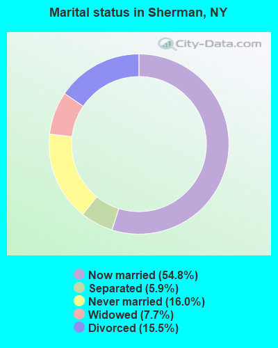
- Never married: 16.0%
- Now married: 54.8%
- Separated: 5.9%
- Widowed: 7.7%
- Divorced: 15.5%
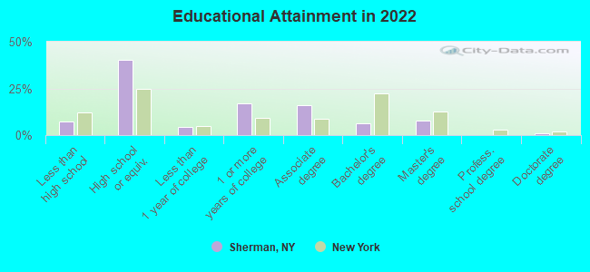
For population 25 years and over in Sherman:
- High school or higher: 90.8%
- Bachelor's degree or higher: 13.8%
- Graduate or professional degree: 8.2%
- Unemployed: 4.6%
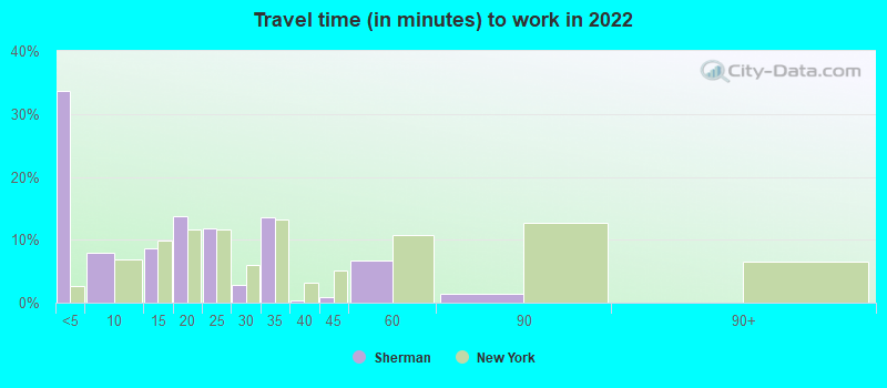
- Mean travel time to work (commute): 21.0 minutes
| Here: | 9.7 |
| New York average: | 13.9 |
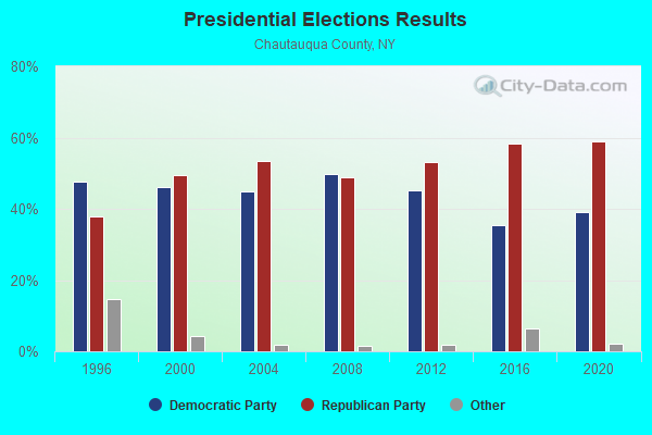
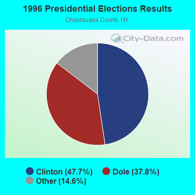
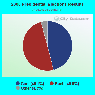
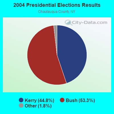
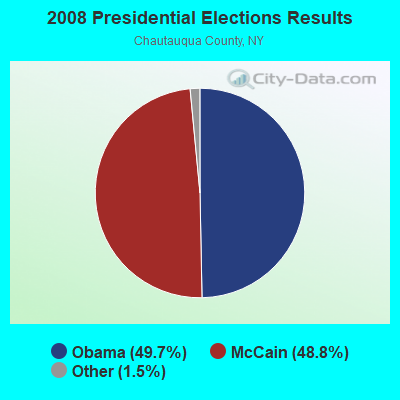
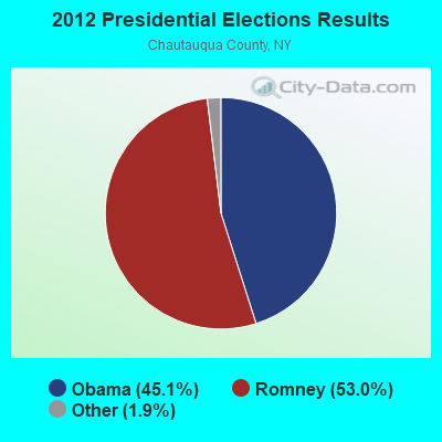
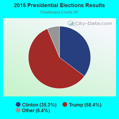
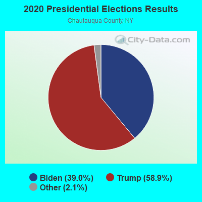
Graphs represent county-level data. Detailed 2008 Election Results
Religion statistics for Sherman, NY (based on Chautauqua County data)
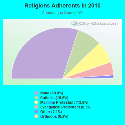
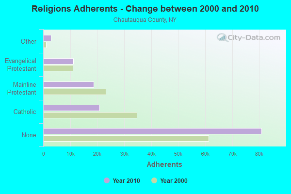
| Religion | Adherents | Congregations |
|---|---|---|
| Catholic | 20,912 | 13 |
| Mainline Protestant | 18,659 | 86 |
| Evangelical Protestant | 11,175 | 105 |
| Other | 2,884 | 19 |
| Orthodox | 230 | 2 |
| Black Protestant | 120 | 1 |
| None | 80,925 | - |
Food Environment Statistics:
| Here: | 2.76 / 10,000 pop. |
| New York: | 4.13 / 10,000 pop. |
| This county: | 0.07 / 10,000 pop. |
| State: | 0.06 / 10,000 pop. |
| Chautauqua County: | 1.12 / 10,000 pop. |
| State: | 0.92 / 10,000 pop. |
| Chautauqua County: | 3.06 / 10,000 pop. |
| New York: | 1.68 / 10,000 pop. |
| This county: | 11.05 / 10,000 pop. |
| New York: | 8.82 / 10,000 pop. |
| This county: | 8.1% |
| State: | 8.2% |
| Here: | 29.3% |
| New York: | 23.8% |
| This county: | 12.4% |
| New York: | 15.6% |
Health and Nutrition:
| This city: | 55.0% |
| New York: | 50.1% |
| This city: | 47.4% |
| New York: | 48.1% |
| This city: | 30.2 |
| State: | 28.5 |
| Sherman: | 12.0% |
| New York: | 20.3% |
| Sherman: | 4.4% |
| State: | 11.1% |
| This city: | 6.1 |
| State: | 6.8 |
| Sherman: | 42.1% |
| New York: | 33.4% |
| Sherman: | 56.8% |
| New York: | 56.5% |
| Sherman: | 89.7% |
| State: | 80.2% |
More about Health and Nutrition of Sherman, NY Residents
| Local government employment and payroll (March 2022) | |||||
| Function | Full-time employees | Monthly full-time payroll | Average yearly full-time wage | Part-time employees | Monthly part-time payroll |
|---|---|---|---|---|---|
| Sewerage | 3 | $5,719 | $22,876 | 0 | $0 |
| Other Government Administration | 3 | $6,507 | $26,028 | 4 | $997 |
| Water Supply | 1 | $4,994 | $59,928 | 0 | $0 |
| Streets and Highways | 1 | $2,028 | $24,336 | 1 | $351 |
| Solid Waste Management | 0 | $0 | 1 | $88 | |
| Police - Other | 0 | $0 | 1 | $1,163 | |
| Totals for Government | 8 | $19,248 | $28,872 | 7 | $2,598 |
Sherman government finances - Expenditure in 2017 (per resident):
- Current Operations - Sewerage: $148,000 ($218.61)
Local Fire Protection: $95,000 ($140.32)
Regular Highways: $94,000 ($138.85)
Water Utilities: $75,000 ($110.78)
Central Staff Services: $51,000 ($75.33)
General - Other: $47,000 ($69.42)
Solid Waste Management: $10,000 ($14.77)
Parks and Recreation: $5,000 ($7.39)
Police Protection: $2,000 ($2.95)
Protective Inspection and Regulation - Other: $1,000 ($1.48)
Judicial and Legal Services: $1,000 ($1.48)
- General - Interest on Debt: $11,000 ($16.25)
- Other Capital Outlay - Regular Highways: $43,000 ($63.52)
Water Utilities: $15,000 ($22.16)
- Total Salaries and Wages: $199,000 ($293.94)
Sherman government finances - Revenue in 2017 (per resident):
- Charges - Sewerage: $162,000 ($239.29)
Solid Waste Management: $5,000 ($7.39)
- Local Intergovernmental - General Local Government Support: $87,000 ($128.51)
Other: $74,000 ($109.31)
- Miscellaneous - General Revenue - Other: $1,000 ($1.48)
- Revenue - Water Utilities: $88,000 ($129.99)
- State Intergovernmental - Highways: $28,000 ($41.36)
General Local Government Support: $6,000 ($8.86)
- Tax - Property: $188,000 ($277.70)
Public Utilities Sales: $6,000 ($8.86)
Other License: $4,000 ($5.91)
Sherman government finances - Debt in 2017 (per resident):
- Long Term Debt - Beginning Outstanding - Unspecified Public Purpose: $145,000 ($214.18)
Outstanding Unspecified Public Purpose: $123,000 ($181.68)
Retired Unspecified Public Purpose: $22,000 ($32.50)
Sherman government finances - Cash and Securities in 2017 (per resident):
- Other Funds - Cash and Securities: $230,000 ($339.73)
Businesses in Sherman, NY
- True Value: 1
Strongest AM radio stations in Sherman:
- WWKB (1520 AM; 50 kW; BUFFALO, NY; Owner: ENTERCOM BUFFALO LICENSE, LLC)
- WRIE (1260 AM; 5 kW; ERIE, PA; Owner: REGENT LICENSEE OF ERIE, INC.)
- WFNN (1330 AM; 5 kW; ERIE, PA; Owner: NM LICENSING, LLC)
- KDKA (1020 AM; 50 kW; PITTSBURGH, PA; Owner: INFINITY BROADCASTING OPERATIONS, INC.)
- WKNR (850 AM; 50 kW; CLEVELAND, OH; Owner: CARON BROADCASTING, INC.)
- WNAE (1310 AM; 5 kW; WARREN, PA; Owner: KINZUA BROADCASTING COMPANY)
- WEYZ (1530 AM; daytime; 1 kW; NORTH EAST, PA)
- WHAM (1180 AM; 50 kW; ROCHESTER, NY; Owner: CITICASTERS LICENSES, L.P.)
- WTAM (1100 AM; 50 kW; CLEVELAND, OH; Owner: JACOR BROADCASTING CORPORATION)
- WWCB (1370 AM; 1 kW; CORRY, PA; Owner: CORRY COMMUNICATIONS CORPORATION)
- WHK (1220 AM; 50 kW; CLEVELAND, OH; Owner: CARON BROADCASTING, INC.)
- WJTN (1240 AM; 1 kW; JAMESTOWN, NY; Owner: MEDIA ONE GROUP, LLC)
- WGR (550 AM; 5 kW; BUFFALO, NY; Owner: ENTERCOM BUFFALO LICENSE, LLC)
Strongest FM radio stations in Sherman:
- WRKT (100.9 FM; NORTH EAST, PA; Owner: NM LICENSING, LLC)
- WUBJ (88.1 FM; JAMESTOWN, NY; Owner: STATE UNIVERSITY OF NEW YORK)
- WWSE (93.3 FM; JAMESTOWN, NY; Owner: MEDIA ONE GROUP, LLC)
- WBKX (96.5 FM; FREDONIA, NY; Owner: CHADWICK BAY BROADCASTING CORPORATION)
- W205BA (88.9 FM; JAMESTOWN, NY; Owner: BIBLE BROADCASTING NETWORK, INC.)
- WKZA (106.9 FM; LAKEWOOD, NY; Owner: CROSS COUNTRY COMMUNICATIONS, LLC)
- WRTS (103.7 FM; ERIE, PA; Owner: NM LICENSING, LLC)
- WMCE (88.5 FM; ERIE, PA; Owner: MERCYHURST COLLEGE)
- WXKC (99.9 FM; ERIE, PA; Owner: REGENT LICENSEE OF ERIE, INC.)
- WNJA (89.7 FM; JAMESTOWN, NY; Owner: WESTERN NEW YORK PUBLIC B/CING ASSOC)
- WFGO (94.7 FM; ERIE, PA; Owner: NM LICENSING, LLC)
- WQHZ (102.3 FM; ERIE, PA; Owner: REGENT LICENSEE OF ERIE, INC.)
- WCOT (90.9 FM; JAMESTOWN, NY; Owner: FAMILY LIFE MINISTRIES, INC.)
- WQLN-FM (91.3 FM; ERIE, PA; Owner: PUBLIC B/C OF NW PENN. INC.)
- WMHU (101.9 FM; JAMESTOWN, NY; Owner: VOX ALLEGANY, L.L.C.)
- WQFX-FM (103.1 FM; RUSSELL, PA; Owner: SOUTHBRIDGE RADIO CORPORATION)
- WCTL (106.3 FM; UNION CITY, PA; Owner: INSPIRATION TIME, INC.)
- WXTA (97.9 FM; EDINBORO, PA; Owner: REGENT LICENSEE OF ERIE, INC.)
- WERG (89.9 FM; ERIE, PA; Owner: GANNON UNIVERSITY)
- W211AE (90.1 FM; MAYVILLE, ETC., NY; Owner: PUBLIC BROADCASTING OF NORTHWEST PENNSYLVANIA, INC.)
TV broadcast stations around Sherman:
- W64AF (Channel 64; SHERMAN, NY; Owner: WESTERN NEW YORK PUBLIC B/CING.ASSN.)
- WNYB (Channel 26; JAMESTOWN, NY; Owner: FAITH BROADCASTING NETWORK, INC.)
- WICU-TV (Channel 12; ERIE, PA; Owner: SJL OF PENNSYLVANIA, INC.)
- W46BA (Channel 46; JAMESTOWN, NY; Owner: WESTERN NEW YORK PUBLIC B/CING.ASSN.)
- WJET-TV (Channel 24; ERIE, PA; Owner: NEXSTAR BROADCASTING OF ERIE, L.L.C.)
- WSEE-TV (Channel 35; ERIE, PA; Owner: INITIAL BROADCASTING OF PENNSYLVANIA LICENSE SUBSIDIARY, LLC)
- WQLN (Channel 54; ERIE, PA; Owner: PUBLIC B/C OF NW PENN. INC.)
- WFXP (Channel 66; ERIE, PA; Owner: MISSION BROADCASTING, INC.)
- W48CH (Channel 48; ERIE, PA; Owner: TRINITY BROADCASTING NETWORK)
- Sherman, New York
- Fatal accident count11
- Vehicles involved in fatal accidents19
- Fatal accidents involving drunk persons:2
- Fatalities13
- Persons involved in fatal accidents28
- Pedestrians involved in fatal accidents0
- New York average
- Fatal accident count10365
- Vehicles involved in fatal accidents15432
- Fatal accidents involving drunk persons2320
- Fatalities11232
- Persons involved in fatal accidents25978
- Pedestrians involved in fatal accidents3399
- National Bridge Inventory (NBI) Statistics
- 33Number of bridges
- 240ft / 72.6mTotal length
- $61,592,000Total costs
- 54,459Total average daily traffic
- 9,686Total average daily truck traffic
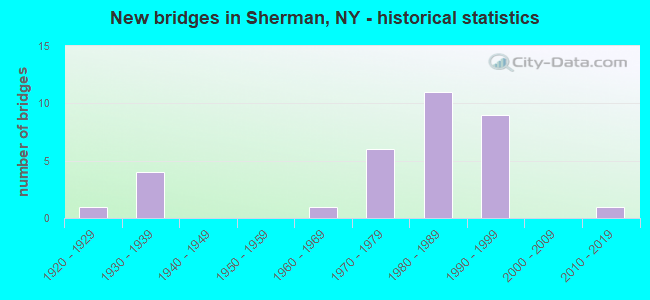
- New bridges - historical statistics
- 11920-1929
- 41930-1939
- 11960-1969
- 61970-1979
- 111980-1989
- 91990-1999
- 12010-2019
FCC Registered Cell Phone Towers:
1 (See the full list of FCC Registered Cell Phone Towers in Sherman)FCC Registered Antenna Towers:
13 (See the full list of FCC Registered Antenna Towers)FCC Registered Broadcast Land Mobile Towers:
2- Lat: 42.163111 Lon: -79.597000, Call Sign: KTR563,
Assigned Frequencies: 155.220 MHz, 155.235 MHz, 155.280 MHz, Grant Date: 12/22/2021, Expiration Date: 02/01/2032, Registrant: Communications Services Of Wny & Pa, 1367 East Second Street, Jamestown, NY 14701, Phone: (716) 664-6200, Fax: (716) 664-5006, Email:
- County Rte 302, West Of Stebbins Road (Lat: 42.162500 Lon: -79.531944), Type: Pole, Structure height: 31 m, Overall height: 33 m, Call Sign: WPYU586,
Assigned Frequencies: 153.035 MHz, Grant Date: 08/05/2023, Expiration Date: 10/30/2033, Certifier: Robert Tiller, Registrant: Utilities Technology Council, 2550 South Clark St., Suite 960, Arlington, VA 22202, Phone: (202) 833-6818, Fax: (202) 872-1331, Email:
FCC Registered Microwave Towers:
6- SHERMAN, 3385 Armenian Rd (Lat: 42.142333 Lon: -79.573917), Type: Tower, Structure height: 91.4 m, Overall height: 97.8 m, Call Sign: WPNH777, Licensee ID: L00128694,
Assigned Frequencies: 6004.50 MHz, Grant Date: 03/15/2011, Expiration Date: 02/01/2021, Cancellation Date: 03/17/2015, Certifier: Michael P Goggin, Registrant: New Cingular Wireless Pcs, LLC
- FRONTIER SHE, 1.5 Mi Se From Sherman Ny E Side Of Armenian Rd. .35 Mi From Freeman Road (Lat: 42.144222 Lon: -79.575333), Type: Mast, Structure height: 54.9 m, Call Sign: WPRR467,
Assigned Frequencies: 6019.32 MHz, 5960.02 MHz, 6019.32 MHz, 5960.02 MHz, 6019.32 MHz, 5960.02 MHz, 6019.32 MHz, 5960.02 MHz, 6019.32 MHz, 5960.02 MHz... (+14 more), Grant Date: 11/03/2020, Expiration Date: 12/26/2030, Certifier: Matthew J Trusso, Registrant: County Of Chautauqua Office Of The Sheriff, 15 E Chautauqua St, Mayville, NY 14757, Phone: (716) 753-4616, Fax: (716) 753-4285, Email:
- PRB1007A, 3385 Armenian Rd (Lat: 42.142778 Lon: -79.574444), Type: Tower, Structure height: 91.4 m, Overall height: 97.6 m, Call Sign: WQFB459,
Assigned Frequencies: 6815.62 MHz, 6835.62 MHz, Grant Date: 03/16/2016, Expiration Date: 06/07/2026, Certifier: Thomas J Cowper, Registrant: Nys Div. Of Homeland Security And Emergency Services, 1220 Washington Ave, Bldg. 7a, Ste 710, State Office Campus, Albany, NY 12242, Phone: (518) 322-4912, Fax: (518) 322-4975, Email:
- SHERMAN, 3199 Armenia Road (Lat: 42.144333 Lon: -79.574861), Type: Tower, Structure height: 54.9 m, Overall height: 58.3 m, Call Sign: WQOT530,
Assigned Frequencies: 6034.15 MHz, 6123.10 MHz, Grant Date: 12/21/2021, Expiration Date: 01/25/2032, Certifier: Gregory M Romano, Registrant: Cellco Partnership, 5055 North Point Pkwy, Np2ne Network Engineering, Alpharetta, GA 30022, Phone: (770) 797-1070, Email:
- UP10325A, 3553 Pelton Road (Lat: 42.154278 Lon: -79.640194), Type: Ltower, Structure height: 79.2 m, Call Sign: WRTX829,
Assigned Frequencies: 17900.0 MHz, 17900.0 MHz, 17900.0 MHz, 17900.0 MHz, 17900.0 MHz, 17900.0 MHz, 17900.0 MHz, 17900.0 MHz, 17900.0 MHz, 17900.0 MHz... (+12 more), Grant Date: 07/27/2022, Expiration Date: 07/27/2032, Cancellation Date: 01/25/2024, Certifier: Jenny Knopf, Registrant: T-Mobile Usa, Inc., 12920 Se 38th Street, Bellevue, WA 98006, Phone: (425) 383-8401, Email:
- 3CHJ924B, 3385 Armenian Rd (Lat: 42.142333 Lon: -79.573917), Type: Gtower, Structure height: 91.4 m, Overall height: 97.8 m, Call Sign: WRTX832,
Assigned Frequencies: 19460.0 MHz, 19460.0 MHz, 19460.0 MHz, 19460.0 MHz, 19460.0 MHz, 19460.0 MHz, 19460.0 MHz, 19460.0 MHz, 19460.0 MHz, 19460.0 MHz... (+12 more), Grant Date: 07/27/2022, Expiration Date: 07/27/2032, Cancellation Date: 01/25/2024, Certifier: Jenny Knopf, Registrant: T-Mobile Usa, Inc., 12920 Se 38th Street, Bellevue, WA 98006, Phone: (425) 383-8401, Email:
FCC Registered Amateur Radio Licenses:
16 (See the full list of FCC Registered Amateur Radio Licenses in Sherman)FAA Registered Aircraft:
1- Aircraft: BEECH C35 (Category: Land, Seats: 4, Weight: Up to 12,499 Pounds, Speed: 120 mph), Engine: CONT MOTOR E185 SERIES (205 HP) (Reciprocating)
N-Number: 677D, N677D, N-677D, Serial Number: D-2950, Year manufactured: 1951, Airworthiness Date: 07/19/1956, Certificate Issue Date: 01/07/2014
Registrant (Individual): Frank Q Pratt, 9651 Hazen Rd, Sherman, NY 14781
| Home Mortgage Disclosure Act Aggregated Statistics For Year 2003 (Based on 1 partial tract) | ||
| C) Refinancings | ||
|---|---|---|
| Number | Average Value | |
| LOANS ORIGINATED | 1 | $41,800 |
| APPLICATIONS APPROVED, NOT ACCEPTED | 0 | $0 |
| APPLICATIONS DENIED | 0 | $0 |
| APPLICATIONS WITHDRAWN | 0 | $0 |
| FILES CLOSED FOR INCOMPLETENESS | 0 | $0 |
Detailed HMDA statistics for the following Tracts: 0367.00
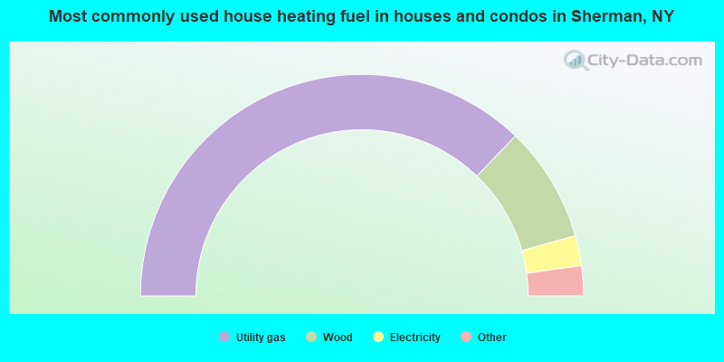
- 74.8%Utility gas
- 17.0%Wood
- 4.4%Electricity
- 2.5%Other fuel
- 1.3%Bottled, tank, or LP gas
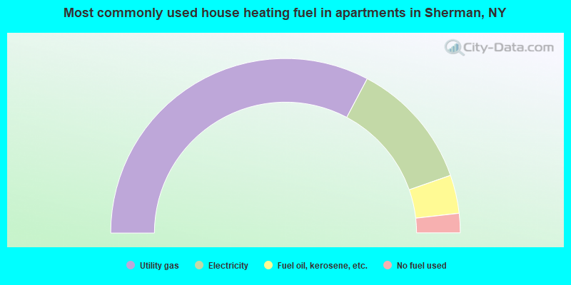
- 65.5%Utility gas
- 23.8%Electricity
- 7.1%Fuel oil, kerosene, etc.
- 3.6%No fuel used
Sherman compared to New York state average:
- Median household income below state average.
- Median house value significantly below state average.
- Unemployed percentage significantly below state average.
- Black race population percentage significantly below state average.
- Hispanic race population percentage significantly below state average.
- Median age below state average.
- Foreign-born population percentage significantly below state average.
- Renting percentage below state average.
- Length of stay since moving in above state average.
- Number of rooms per house above state average.
- Number of college students below state average.
- Percentage of population with a bachelor's degree or higher below state average.
Sherman on our top lists:
- #91 on the list of "Top 100 cities with old houses but young residents"
- #8 on the list of "Top 101 counties with the lowest percentage of residents relocating from other counties between 2010 and 2011"
- #11 on the list of "Top 101 counties with the largest number of people moving out compared to moving in (pop. 50,000+)"
- #15 on the list of "Top 101 counties with the lowest percentage of residents relocating to foreign countries in 2011"
- #32 on the list of "Top 101 counties with the lowest percentage of residents relocating to other counties in 2011"
- #84 on the list of "Top 101 counties with the lowest number of births per 1000 residents 2007-2013"

|
Total of 5 patent applications in 2008-2024.