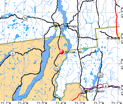
Putnam, New York
Submit your own pictures of this town and show them to the world
- OSM Map
- General Map
- Google Map
- MSN Map
Population change since 2000: -5.6%
 |
| Males: 305 | |
| Females: 304 |
| Median resident age: | 49.4 years |
| New York median age: | 40.7 years |
Zip codes: 12861.
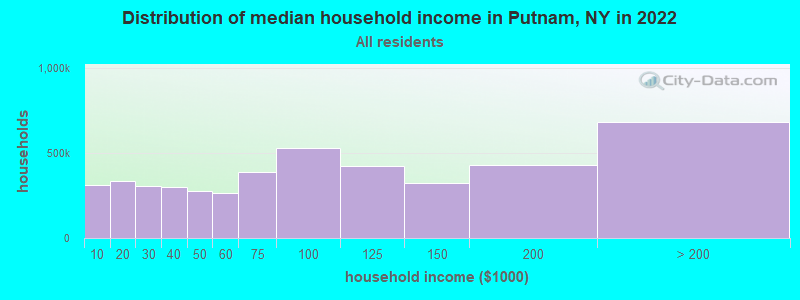
| Putnam: | $90,929 |
| NY: | $79,557 |
Estimated per capita income in 2022: $40,923 (it was $21,355 in 2000)
Putnam town income, earnings, and wages data
Estimated median house or condo value in 2022: $188,619 (it was $80,600 in 2000)
| Putnam: | $188,619 |
| NY: | $400,400 |
Mean prices in 2022: all housing units: $230,821; detached houses: $233,893; townhouses or other attached units: $212,177; in 2-unit structures: $329,174; in 3-to-4-unit structures: over $1,000,000; in 5-or-more-unit structures: $895,403; mobile homes: $83,938
Detailed information about poverty and poor residents in Putnam, NY
Compare current foreclosures near Putnam, NY:
| Photo | Address | Area | Beds / Baths | Price | Details |
|---|---|---|---|---|---|

|
#1
Callahan Ln
Fort Ann, NY 12827
|
1,000 sq. feet
|
1 baths 3 beds |
$118,500
|
show details |

|
#2
Creek Rd
Crown Point, NY 12928
|
1,640 sq. feet
|
2 baths 3 beds |
$42,000
|
show details |

|
#3
Algonkin St
Ticonderoga, NY 12883
|
1,294 sq. feet
|
1 baths 3 beds |
$29,900
|
show details |

|
#4
Furnace St
Fair Haven, VT 05743
|
3,160 sq. feet
|
3 baths 7 beds |
show details | |

|
#5
Shore Airport Rd
Ticonderoga, NY 12883
|
2,878 sq. feet
|
4 baths 5 beds |
show details | |

|
#6
Saunders St
Whitehall, NY 12887
|
1,500 sq. feet
|
1 baths 3 beds |
show details | |

|
#7
Mountain St
Whitehall, NY 12887
|
1,752 sq. feet
|
1 baths 3 beds |
show details | |

|
#8
Wicker St
Ticonderoga, NY 12883
|
1,009 sq. feet
|
1 baths 3 beds |
show details | |

|
#9
Summit Dr
Hague, NY 12836
|
1,435 sq. feet
|
2 baths 3 beds |
show details | |

|
#10
Creek Rd
Crown Point, NY 12928
|
1,648 sq. feet
|
1 baths 3 beds |
show details |
| Photo | Address | Area | Beds / Baths | Price | Details |
|---|---|---|---|---|---|

|
#11
County Route 11
Whitehall, NY 12887
|
1,058 sq. feet
|
2 baths 3 beds |
show details | |

|
#12
Pike Brook Rd
Clemons, NY 12819
|
1,976 sq. feet
|
1 baths 4 beds |
show details | |

|
#13
Ferry Rd
Crown Point, NY 12928
|
960 sq. feet
|
1 baths 3 beds |
show details | |

|
#14
Woody Ln
Ticonderoga, NY 12883
|
1,280 sq. feet
|
1 baths 3 beds |
show details | |

|
#15
4th Ave
Whitehall, NY 12887
|
1,044 sq. feet
|
1 baths 2 beds |
show details | |

|
#16
Alexandria Ave
Ticonderoga, NY 12883
|
720 sq. feet
|
- baths 3 beds |
show details | |

|
#17
Castleton Meadows Ln Apt 6b
Castleton, VT 05735
|
- sq. feet
|
- baths - beds |
show details | |

|
#18
Caernarvon St
Fair Haven, VT 05743
|
- sq. feet
|
- baths - beds |
show details | |

|
#19
Vaughn St
Whitehall, NY 12887
|
- sq. feet
|
- baths - beds |
show details | |

|
#20
State Route 8
Brant Lake, NY 12815
|
- sq. feet
|
- baths - beds |
show details |
| Photo | Address | Area | Beds / Baths | Price | Details |
|---|---|---|---|---|---|

|
#21
Cuttinghill Rd
Whiting, VT 05778
|
- sq. feet
|
- baths - beds |
show details | |

|
#22
Jenison Rd
Shoreham, VT 05770
|
- sq. feet
|
- baths - beds |
show details | |

|
#23
Route 73
Orwell, VT 05760
|
- sq. feet
|
- baths - beds |
show details | |

|
#24
Stage Rd
Fair Haven, VT 05743
|
- sq. feet
|
- baths - beds |
show details | |

|
#25
Belgo Rd
Castleton, VT 05735
|
- sq. feet
|
- baths - beds |
show details | |

|
#26
Leicester Whiting Rd
Whiting, VT 05778
|
- sq. feet
|
- baths - beds |
show details | |

|
Check over 1 million property listings on Foreclosure.com!
|
browse all offers | |||

- 60399.0%White alone
- 50.8%Two or more races
- 10.2%Hispanic
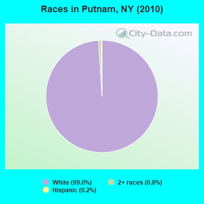
Races in Putnam detailed stats: ancestries, foreign born residents, place of birth
 Recent articles from our blog. Our writers, many of them Ph.D. graduates or candidates, create easy-to-read articles on a wide variety of topics.


Latest news from Putnam, NY collected exclusively by city-data.com from local newspapers, TV, and radio stations
Ancestries: Irish (30.2%), French (18.8%), United States (11.3%), English (11.2%), German (10.1%), Italian (8.1%).
Current Local Time: EST time zone
Incorporated in 1839
Elevation: 339 feet
Land area: 33.2 square miles.
Population density: 18 people per square mile (very low).
7 residents are foreign born
| This town: | 1.1% |
| New York: | 20.4% |
| Putnam town: | 1.7% ($1,378) |
| New York: | 1.9% ($2,847) |
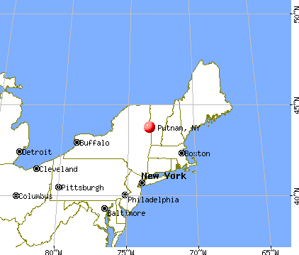
Nearest city with pop. 50,000+: Schenectady, NY  (70.1 miles , pop. 61,821).
Nearest city with pop. 200,000+: Boston, MA (153.4 miles , pop. 589,141).
Nearest city with pop. 1,000,000+: Bronx, NY (201.8 miles , pop. 1,332,650).
Nearest cities:
), ), ), ), ), Latitude: 43.75 N, Longitude: 73.42 W
Area code: 518

| Here: | 4.1% |
| New York: | 4.4% |
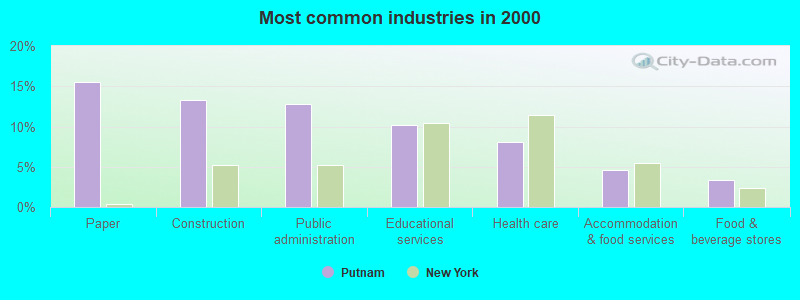
- Paper (15.5%)
- Construction (13.4%)
- Public administration (12.7%)
- Educational services (10.2%)
- Health care (8.1%)
- Accommodation & food services (4.7%)
- Food & beverage stores (3.4%)
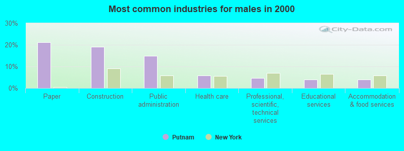
- Paper (21.3%)
- Construction (19.0%)
- Public administration (14.9%)
- Health care (5.7%)
- Professional, scientific, technical services (4.6%)
- Educational services (4.0%)
- Accommodation & food services (4.0%)
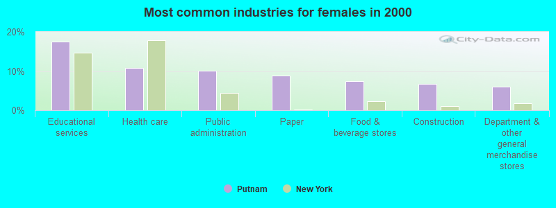
- Educational services (17.6%)
- Health care (10.8%)
- Public administration (10.1%)
- Paper (8.8%)
- Food & beverage stores (7.4%)
- Construction (6.8%)
- Department & other general merchandise stores (6.1%)
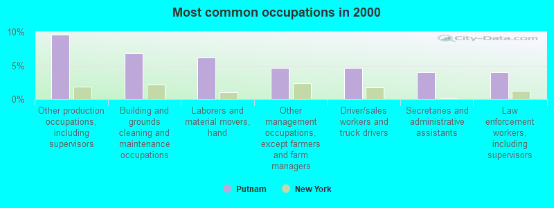
- Other production occupations, including supervisors (9.6%)
- Building and grounds cleaning and maintenance occupations (6.8%)
- Laborers and material movers, hand (6.2%)
- Other management occupations, except farmers and farm managers (4.7%)
- Driver/sales workers and truck drivers (4.7%)
- Secretaries and administrative assistants (4.0%)
- Law enforcement workers, including supervisors (4.0%)
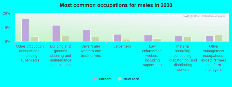
- Other production occupations, including supervisors (16.1%)
- Building and grounds cleaning and maintenance occupations (11.5%)
- Driver/sales workers and truck drivers (8.6%)
- Carpenters (5.2%)
- Law enforcement workers, including supervisors (4.6%)
- Material recording, scheduling, dispatching, and distributing workers (4.0%)
- Other management occupations, except farmers and farm managers (4.0%)

- Laborers and material movers, hand (10.8%)
- Secretaries and administrative assistants (8.8%)
- Registered nurses (8.1%)
- Other office and administrative support workers, including supervisors (6.8%)
- Preschool, kindergarten, elementary, and middle school teachers (6.1%)
- Retail sales workers, except cashiers (6.1%)
- Other management occupations, except farmers and farm managers (5.4%)
Average climate in Putnam, New York
Based on data reported by over 4,000 weather stations


(lower is better)
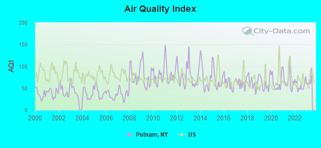
Air Quality Index (AQI) level in 2022 was 56.9. This is better than average.
| City: | 56.9 |
| U.S.: | 72.6 |
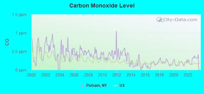
Carbon Monoxide (CO) [ppm] level in 2022 was 0.251. This is about average. Closest monitor was 23.6 miles away from the city center.
| City: | 0.251 |
| U.S.: | 0.251 |
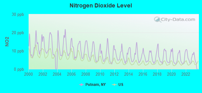
Nitrogen Dioxide (NO2) [ppb] level in 2022 was 6.51. This is worse than average. Closest monitor was 23.6 miles away from the city center.
| City: | 6.51 |
| U.S.: | 5.11 |
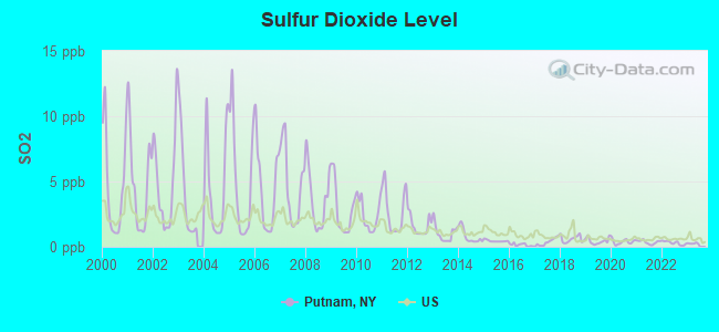
Sulfur Dioxide (SO2) [ppb] level in 2022 was 0.299. This is significantly better than average. Closest monitor was 19.4 miles away from the city center.
| City: | 0.299 |
| U.S.: | 1.515 |
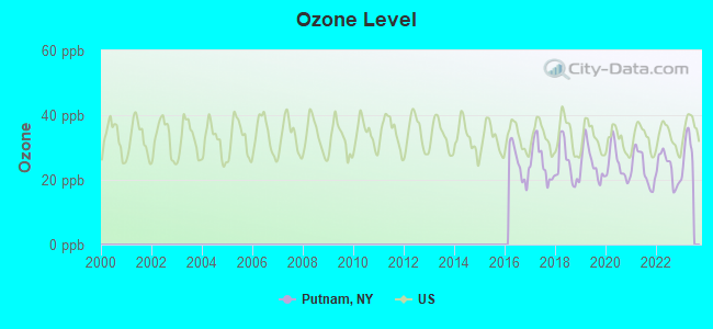
Ozone [ppb] level in 2022 was 23.5. This is significantly better than average. Closest monitor was 23.1 miles away from the city center.
| City: | 23.5 |
| U.S.: | 33.3 |
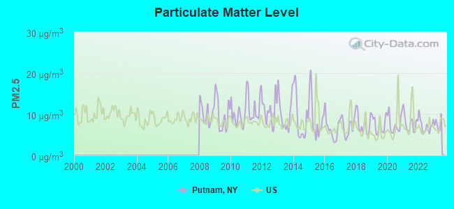
Particulate Matter (PM2.5) [µg/m3] level in 2022 was 7.23. This is about average. Closest monitor was 9.0 miles away from the city center.
| City: | 7.23 |
| U.S.: | 8.11 |
Tornado activity:
Putnam-area historical tornado activity is below New York state average. It is 79% smaller than the overall U.S. average.
On 8/20/1968, a category F3 (max. wind speeds 158-206 mph) tornado 54.3 miles away from the Putnam town center injured one person and caused between $5000 and $50,000 in damages.
On 6/11/1976, a category F2 (max. wind speeds 113-157 mph) tornado 33.1 miles away from the town center caused between $50,000 and $500,000 in damages.
Earthquake activity:
Putnam-area historical earthquake activity is significantly above New York state average. It is 69% smaller than the overall U.S. average.On 10/7/1983 at 10:18:46, a magnitude 5.3 (5.1 MB, 5.3 LG, 5.1 ML, Class: Moderate, Intensity: VI - VII) earthquake occurred 48.4 miles away from Putnam center
On 4/20/2002 at 10:50:47, a magnitude 5.3 (5.3 ML, Depth: 3.0 mi) earthquake occurred 54.9 miles away from the city center
On 4/20/2002 at 10:50:47, a magnitude 5.2 (5.2 MB, 4.2 MS, 5.2 MW, 5.0 MW) earthquake occurred 53.5 miles away from Putnam center
On 1/19/1982 at 00:14:42, a magnitude 4.7 (4.5 MB, 4.7 MD, 4.5 LG, Class: Light, Intensity: IV - V) earthquake occurred 92.5 miles away from Putnam center
On 10/16/2012 at 23:12:25, a magnitude 4.7 (4.7 ML, Depth: 10.0 mi) earthquake occurred 138.4 miles away from the city center
On 6/17/1991 at 08:53:16, a magnitude 4.1 (4.0 MB, 4.0 LG, Depth: 3.1 mi) earthquake occurred 100.0 miles away from Putnam center
Magnitude types: regional Lg-wave magnitude (LG), body-wave magnitude (MB), duration magnitude (MD), local magnitude (ML), surface-wave magnitude (MS), moment magnitude (MW)
Natural disasters:
The number of natural disasters in Washington County (14) is near the US average (15).Major Disasters (Presidential) Declared: 8
Emergencies Declared: 6
Causes of natural disasters: Floods: 3, Hurricanes: 3, Storms: 3, Winter Storms: 3, Blizzard: 1, Earthquake: 1, Power Outage: 1, Other: 2 (Note: some incidents may be assigned to more than one category).
Hospitals and medical centers near Putnam:
Amtrak stations near Putnam:
- 8 miles: TICONDEROGA (RTE. 74 (FORT TICONDEROGA RD.)) . Services: enclosed waiting area, public restrooms, free short-term parking, free long-term parking, call for taxi service.
- 14 miles: FAIR HAVEN (DEPOT & WATER STS.)
- 14 miles: WHITEHALL (MAIN ST.) . Services: enclosed waiting area, public payphones, free short-term parking, free long-term parking, call for taxi service.
Colleges/universities with over 2000 students nearest to Putnam:
- Castleton State College (about 16 miles; Castleton, VT; Full-time enrollment: 2,079)
- Middlebury College (about 22 miles; Middlebury, VT; FT enrollment: 3,077)
- Adirondack Community College (about 30 miles; Queensbury, NY; FT enrollment: 2,826)
- Norwich University (about 47 miles; Northfield, VT; FT enrollment: 4,221)
- Skidmore College (about 49 miles; Saratoga Springs, NY; FT enrollment: 2,753)
- SUNY Empire State College (about 50 miles; Saratoga Springs, NY; FT enrollment: 9,473)
- Champlain College (about 52 miles; Burlington, VT; FT enrollment: 2,623)
Public elementary/middle school in Putnam:
- PUTNAM CENTRAL SCHOOL (Students: 44, Location: 126 COUNTY RT 2, Grades: PK-6)
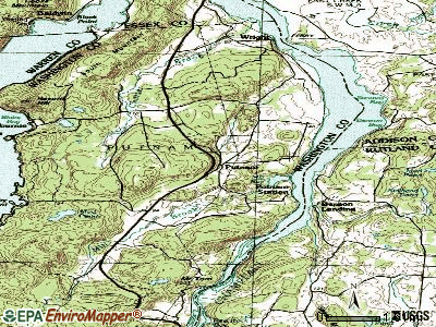
Points of interest:
Notable locations in Putnam: Camp Sagamore (A), Camp Mohican (B), Camp Endion (C), Putnam Volunteer Fire Company (D). Display/hide their locations on the map
Churches in Putnam include: Log Chapel (A), Putnam Church (B). Display/hide their locations on the map
Cemeteries: Putnam Cemetery (1), Meadow Knoll Cemetery (2). Display/hide their locations on the map
Lakes and swamps: Mud Pond (A), Negro Marsh (B), Charter Marsh (C). Display/hide their locations on the map
Streams, rivers, and creeks: Charter Brook (A), Sucker Brook (B), Mill Brook (C). Display/hide their locations on the map
Drinking water stations with addresses in Putnam and their reported violations in the past:
GULL BAY BEACH (Population served: 300, Groundwater):Past health violations:Past monitoring violations:
- Treatment Technique (SWTR and GWR) - In AUG-2013, Contaminant: GROUNDWATER RULE. Follow-up actions: St Boil Water Order (AUG-02-2013), St Formal NOV issued (AUG-02-2013), St Compliance achieved (AUG-05-2013)
- Monitoring, Repeat Major (TCR) - Between JUL-2006 and SEP-2006, Contaminant: Coliform (TCR). Follow-up actions: St Compliance achieved (AUG-08-2006), St Public Notif requested (SEP-28-2006), St Formal NOV issued (SEP-28-2006), St Public Notif requested (JAN-10-2007), St Formal NOV issued (JAN-10-2007)
- 2 routine major monitoring violations
| This town: | 2.3 people |
| New York: | 2.6 people |
| This town: | 71.4% |
| Whole state: | 63.5% |
| This town: | 7.7% |
| Whole state: | 6.8% |
Likely homosexual households (counted as self-reported same-sex unmarried-partner households)
- Lesbian couples: 0.0% of all households
- Gay men: 0.4% of all households
| This town: | 5.7% |
| Whole state: | 14.6% |
| This town: | 0.6% |
| Whole state: | 7.4% |
For population 15 years and over in Putnam:
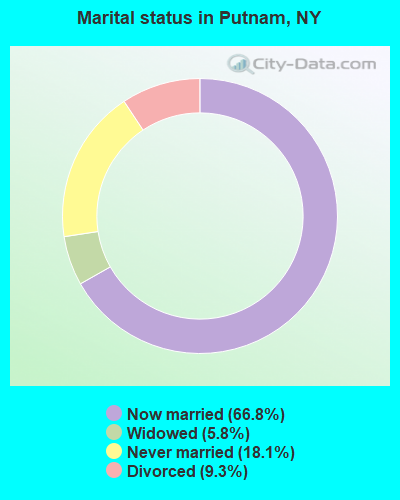
- Never married: 18.1%
- Now married: 66.8%
- Separated: 0.0%
- Widowed: 5.8%
- Divorced: 9.3%
For population 25 years and over in Putnam:
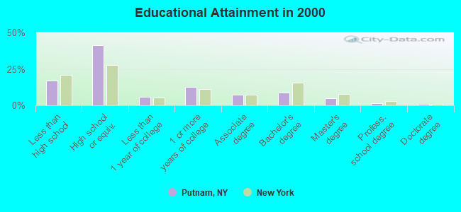
- High school or higher: 83.2%
- Bachelor's degree or higher: 16.4%
- Graduate or professional degree: 7.6%
- Unemployed: 8.3%
- Mean travel time to work (commute): 26.5 minutes
| Here: | 10.8 |
| New York average: | 14.2 |
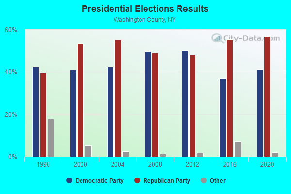
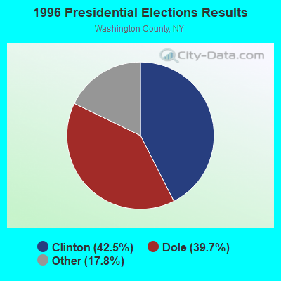
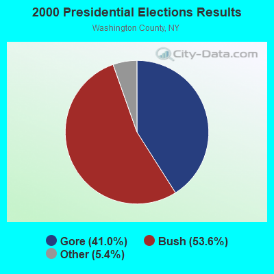
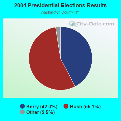
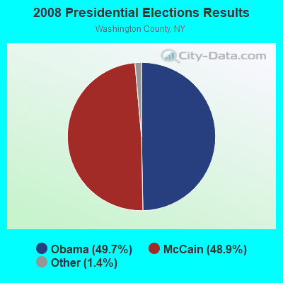

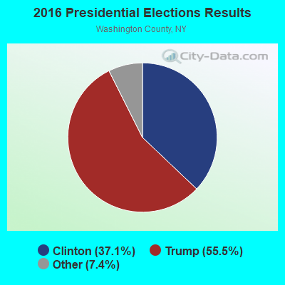
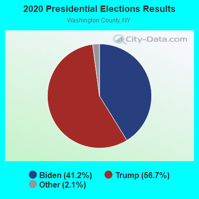
Graphs represent county-level data. Detailed 2008 Election Results
Religion statistics for Putnam, NY (based on Washington County data)
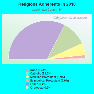
| Religion | Adherents | Congregations |
|---|---|---|
| Catholic | 13,581 | 10 |
| Mainline Protestant | 6,259 | 54 |
| Evangelical Protestant | 1,856 | 19 |
| Other | 256 | 4 |
| Orthodox | 140 | 3 |
| None | 41,124 | - |
Food Environment Statistics:
| Here: | 1.92 / 10,000 pop. |
| New York: | 4.13 / 10,000 pop. |
| This county: | 4.32 / 10,000 pop. |
| New York: | 1.68 / 10,000 pop. |
| Washington County: | 7.51 / 10,000 pop. |
| New York: | 8.82 / 10,000 pop. |
| Washington County: | 8.1% |
| New York: | 8.2% |
| This county: | 26.7% |
| New York: | 23.8% |
| Washington County: | 17.1% |
| State: | 15.6% |
Strongest AM radio stations in Putnam:
- WIPS (1250 AM; 1 kW; TICONDEROGA, NY; Owner: CALVIN HUGH CARR)
- WGY (810 AM; 50 kW; SCHENECTADY, NY; Owner: CLEAR CHANNEL BROADCASTING LICENSES, INC.)
- WSYB (1380 AM; 5 kW; RUTLAND, VT; Owner: CAPSTAR TX LIMITED PARTNERSHIP)
- WCHP (760 AM; 35 kW; CHAMPLAIN, NY; Owner: CHAMPLAIN RADIO, INC.)
- WPTR (1540 AM; 50 kW; ALBANY, NY; Owner: KIMTRON, INC.)
- WNNZ (640 AM; 50 kW; WESTFIELD, MA; Owner: CLEAR CHANNEL BROADCASTING LICENSES, INC.)
- WICY (1490 AM; 50 kW; MALONE, NY; Owner: CARTIER COMMUNICATIONS INC.)
- WCRN (830 AM; 50 kW; WORCESTER, MA; Owner: CARTER BROADCASTING CORPORATION)
- WRKO (680 AM; 50 kW; BOSTON, MA; Owner: ENTERCOM BOSTON LICENSE, LLC)
- WDEV (550 AM; 5 kW; WATERBURY, VT; Owner: RADIO VERMONT, INC.)
- WEEI (850 AM; 50 kW; BOSTON, MA; Owner: ENTERCOM BOSTON LICENSE, LLC)
- WVMT (620 AM; 5 kW; BURLINGTON, VT; Owner: SISON BROADCASTING, INC.)
- WIRD (920 AM; 5 kW; LAKE PLACID, NY; Owner: RADIO LAKE PLACID INC)
Strongest FM radio stations in Putnam:
- WANC (103.9 FM; TICONDEROGA, NY; Owner: WAMC)
- WEXP (101.5 FM; BRANDON, VT; Owner: VOX VERMONT, L.L.C.)
- WEBK (105.3 FM; KILLINGTON, VT; Owner: 6 JOHNSON ROAD LICENSES, INC.)
- WJJR (98.1 FM; RUTLAND, VT; Owner: 6 JOHNSON ROAD LICENSES, INC.)
- WZRT (97.1 FM; RUTLAND, VT; Owner: CAPSTAR TX LIMITED PARTNERSHIP)
- WXAL-FM (93.7 FM; ADDISON, VT; Owner: ADDISON BROADCASTING COMPANY, INC.)
- WGLV (91.7 FM; WOODSTOCK, VT; Owner: CHRISTIAN MINISTRIES INC)
- WHDQ-FM1 (106.1 FM; RUTLAND, VT; Owner: GREAT NORTHERN RADIO, L.L.C.)
- WXLG (89.9 FM; NORTH CREEK, NY; Owner: THE ST. LAWRENCE UNIVERSITY)
- WDEV-FM (96.1 FM; WARREN, VT; Owner: RADIO VERMONT, INC.)
- WJEN (94.5 FM; RUTLAND, VT; Owner: 6 JOHNSON ROAD LICENSES, INC.)
- WEQX (102.7 FM; MANCHESTER, VT; Owner: NORTHSHIRE COMMUNICATIONS, INC.)
- WJAN (95.1 FM; SUNDERLAND, VT; Owner: 6 JOHNSON ROAD LICENSES, INC.)
- WKBE (100.3 FM; WARRENSBURG, NY; Owner: 6 JOHNSON ROAD LICENSES, INC.)
- WCKM-FM (99.1 FM; LAKE GEORGE, NY; Owner: ENTERTRONICS, INC.)
- WNYQ (105.7 FM; QUEENSBURY, NY; Owner: VOX NEW YORK, L.L.C.)
- WCVT (101.7 FM; STOWE, VT; Owner: RADIO VERMONT CLASSICS, L.L.C.)
- WVPS (107.9 FM; BURLINGTON, VT; Owner: VERMONT PUBLIC RADIO)
- WEZF (92.9 FM; BURLINGTON, VT; Owner: CAPSTAR TX LIMITED PARTNERSHIP)
- WVPR (89.5 FM; WINDSOR, VT; Owner: VERMONT PUBLIC RADIO)
TV broadcast stations around Putnam:
- WVER (Channel 28; RUTLAND, VT; Owner: VERMONT ETV, INC.)
- W61CE (Channel 61; RUTLAND, VT; Owner: MARGARET SANGUINETTI (ADMINISTRATRIX OF THE ESTATE))
- W67AW (Channel 67; TICONDEROGA, NY; Owner: MOUNTAIN LAKES PUB.TELECOMM.COUNCIL)
- National Bridge Inventory (NBI) Statistics
- 2Number of bridges
- 7ft / 1.9mTotal length
- $688,000Total costs
- 115Total average daily traffic
- 6Total average daily truck traffic
- 161Total future (year 2037) average daily traffic
FCC Registered Antenna Towers:
6- KELLYE E ABERNATHY, Rt 301 (Lat: 41.431667 Lon: -73.880556), Type: 112.1, Overall height: 112.1 m, Registrant: Cingular Wireless LLC, Kellye.E.Abernathy@cingular.Com, , Plano, Phone: (469) 229-7422
- David C Jatlow, Rt 301 (Lat: 41.431667 Lon: -73.880556), Type: 112.1, Overall height: 112.1 m, Registrant: Cingular Wireless (Formerly At&t Wireless), David.Jatlow@cingular.Com, , Washi-ngton, Phone: (202) 223-9222
- DAVID C JATLOW, Rt 301 (Lat: 41.431667 Lon: -73.880556), Type: 112.1, Overall height: 112.1 m, Registrant: Cingular Wireless LLC, Kellye.E.Abernathy, , Dalla-s, Phone: (972) 733-2092
- David Saska, Rt 301 (Lat: 41.431667 Lon: -73.880556), Type: 112.1, Overall height: 112.1 m, Registrant: At&t Mobility LLC, Ka8805@att.Com, , Plano, Phone: (469) 229-7422
- DANE ERSHEN, Rt 301 (Lat: 41.431667 Lon: -73.880556), Type: 112.1, Overall height: 112.1 m, Registrant: At&t Mobility LLC, Lg5201@att.Com, , Plano, Phone: (469) 229-7471
- Rt 301 (Lat: 41.431667 Lon: -73.880556), Type: 112.1, Overall height: 112.1 m, Registrant: At&t Wireless Services Inc, Esther.Hilliard@attws.Com, , Washi-ngton, Phone: (202) 223-9222
FCC Registered Broadcast Land Mobile Towers:
1- Putnam L1, Along Railway Tracks - 405 Hutton Square Rd (Lat: 43.759444 Lon: -73.365833), Call Sign: WQWS802,
Assigned Frequencies: 160.425 MHz, 160.267 MHz, 161.100 MHz, 160.590 MHz, Grant Date: 11/09/2015, Expiration Date: 11/09/2025, Cancellation Date: 06/01/2023, Certifier: Celina Kawasima, Registrant: Canadian Pacific Railway, 5th Floor - 120 South 6th Street, Minneapolis, MN 55402, Phone: (403) 319-6007, Fax: (612) 851-5688, Email:
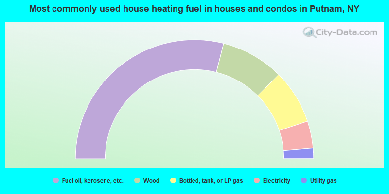
- 57.9%Fuel oil, kerosene, etc.
- 17.1%Wood
- 14.8%Bottled, tank, or LP gas
- 7.4%Electricity
- 2.8%Utility gas
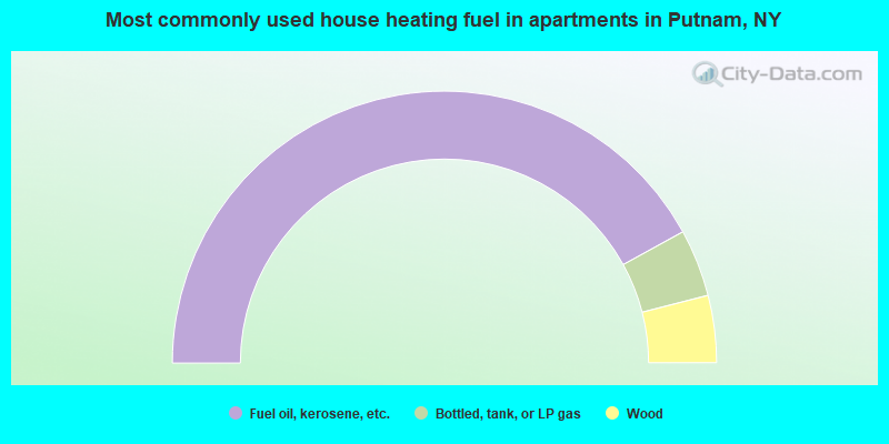
- 84.0%Fuel oil, kerosene, etc.
- 8.0%Bottled, tank, or LP gas
- 8.0%Wood
Putnam compared to New York state average:
- Median house value below state average.
- Unemployed percentage below state average.
- Black race population percentage significantly below state average.
- Hispanic race population percentage significantly below state average.
- Median age significantly above state average.
- Foreign-born population percentage significantly below state average.
- Renting percentage significantly below state average.
- Length of stay since moving in significantly above state average.
- Number of rooms per house significantly below state average.
- House age significantly below state average.
- Number of college students below state average.
- Percentage of population with a bachelor's degree or higher below state average.

|
Total of 2 patent applications in 2008-2024.