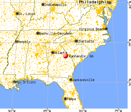
Panhandle, Georgia
Submit your own pictures of this place and show them to the world
- OSM Map
- General Map
- Google Map
- MSN Map

| Males: 96 | |
| Females: 126 |
| Median resident age: | 41.6 years |
| Georgia median age: | 33.4 years |
Zip code: 30823
| Panhandle: | $37,493 |
| GA: | $72,837 |
Estimated per capita income in 2022: $27,103 (it was $15,451 in 2000)
Panhandle CCD income, earnings, and wages data
Estimated median house or condo value in 2022: $144,426 (it was $67,000 in 2000)
| Panhandle: | $144,426 |
| GA: | $297,400 |
Mean prices in 2022: all housing units: $159,465; detached houses: $233,258; townhouses or other attached units: $49,082; mobile homes: $65,918
Detailed information about poverty and poor residents in Panhandle, GA


- 19581.6%White alone
- 3916.3%Black alone
- 31.3%American Indian alone
- 20.8%Hispanic

Races in Panhandle detailed stats: ancestries, foreign born residents, place of birth
 Recent articles from our blog. Our writers, many of them Ph.D. graduates or candidates, create easy-to-read articles on a wide variety of topics.
Current Local Time: EST time zone
Elevation: 597 feet
Land area: 27.3 square miles.
Population density: 8.1 people per square mile (very low).
| Panhandle CCD: | 0.6% ($410) |
| Georgia: | 0.9% ($919) |
Nearest city with pop. 50,000+: Augusta-Richmond County, GA  (27.0 miles , pop. 195,182).
Nearest city with pop. 200,000+: Atlanta, GA (115.9 miles , pop. 416,474).
Nearest city with pop. 1,000,000+: Philadelphia, PA (615.1 miles , pop. 1,517,550).
Nearest cities:
), ), Latitude: 33.31 N, Longitude: 82.47 W
Area code commonly used in this area: 706


| Here: | 3.6% |
| Georgia: | 2.9% |
Average climate in Panhandle, Georgia
Based on data reported by over 4,000 weather stations


Tornado activity:
Panhandle-area historical tornado activity is slightly below Georgia state average. It is 7% smaller than the overall U.S. average.
On 11/22/1992, a category F4 (max. wind speeds 207-260 mph) tornado 34.4 miles away from the Panhandle place center killed 5 people and injured 86 people and caused between $5,000,000 and $50,000,000 in damages.
On 11/22/1992, a category F3 (max. wind speeds 158-206 mph) tornado 25.5 miles away from the place center killed one person and injured 9 people and caused between $500,000 and $5,000,000 in damages.
Earthquake activity:
Panhandle-area historical earthquake activity is significantly above Georgia state average. It is 7% smaller than the overall U.S. average.On 8/2/1974 at 08:52:09, a magnitude 4.9 (4.3 MB, 4.9 LG, Class: Light, Intensity: IV - V) earthquake occurred 38.8 miles away from Panhandle center
On 11/22/1974 at 05:25:55, a magnitude 4.7 (4.7 MB) earthquake occurred 137.4 miles away from Panhandle center
On 8/9/2020 at 12:07:37, a magnitude 5.1 (5.1 MW, Depth: 4.7 mi, Class: Moderate, Intensity: VI - VII) earthquake occurred 232.3 miles away from Panhandle center
On 4/29/2003 at 08:59:39, a magnitude 4.9 (4.4 MB, 4.6 MW, 4.9 LG) earthquake occurred 199.2 miles away from Panhandle center
On 2/15/2014 at 03:23:38, a magnitude 4.1 (4.1 MW, Depth: 3.2 mi) earthquake occurred 41.0 miles away from the city center
On 11/30/1973 at 07:48:41, a magnitude 4.7 (4.7 MB, 4.6 ML) earthquake occurred 192.0 miles away from the city center
Magnitude types: regional Lg-wave magnitude (LG), body-wave magnitude (MB), local magnitude (ML), moment magnitude (MW)
Natural disasters:
The number of natural disasters in Warren County (6) is a lot smaller than the US average (15).Major Disasters (Presidential) Declared: 2
Emergencies Declared: 3
Causes of natural disasters: Winter Storms: 2, Drought: 1, Hurricane: 1, Storm: 1, Tornado: 1, Other: 1 (Note: some incidents may be assigned to more than one category).
Colleges/universities with over 2000 students nearest to Panhandle:
- Augusta Technical College (about 26 miles; Augusta, GA; Full-time enrollment: 3,494)
- Georgia Regents University (about 30 miles; Augusta, GA; FT enrollment: 6,862)
- Aiken Technical College (about 40 miles; Graniteville, SC; FT enrollment: 2,107)
- University of South Carolina-Aiken (about 45 miles; Aiken, SC; FT enrollment: 2,815)
- Georgia Military College-Distance Learning Campuses (about 47 miles; Milledgeville, GA; FT enrollment: 6,438)
- Georgia College and State University (about 48 miles; Milledgeville, GA; FT enrollment: 6,271)
- East Georgia State College (about 51 miles; Swainsboro, GA; FT enrollment: 2,345)
Points of interest:
Notable location: Warren County Fire Department Panhandle Station (A). Display/hide its location on the map
Churches in Panhandle include: Mount Aldrich Church (A), Mount Beulah Baptist Church (B), Reedy Creek Church (C). Display/hide their locations on the map
Cemeteries: Adkins Cemetery (1), McLain Cemetery (2), Hobbs Cemetery (3), Huff Cemetery (4), Smith Cemetery (5), Ivey-Jones Cemetery (6), Langham Cemetery (7). Display/hide their locations on the map
Reservoirs: Newsomes Pond (A), Langham Lake (B), Reese Lake (C), Kaolin Lake (D), Kaolin Mines Lake (E). Display/hide their locations on the map
Streams, rivers, and creeks: Thomson Ford Branch (A), Thompson Branch (B), Guy Branch (C), Mill Branch (D), McLean Creek (E), Little Brier Creek (F). Display/hide their locations on the map
| This place: | 2.2 people |
| Georgia: | 2.6 people |
| This place: | 61.7% |
| Whole state: | 68.5% |
| This place: | 4.9% |
| Whole state: | 5.9% |
Likely homosexual households (counted as self-reported same-sex unmarried-partner households)
- Lesbian couples: 1.2% of all households
- Gay men: 0.0% of all households
| This place: | 25.4% |
| Whole state: | 13.0% |
| This place: | 11.2% |
| Whole state: | 6.1% |
For population 15 years and over in Panhandle:

- Never married: 17.4%
- Now married: 50.6%
- Separated: 3.4%
- Widowed: 21.3%
- Divorced: 10.7%
For population 25 years and over in Panhandle:
- High school or higher: 61.9%
- Bachelor's degree or higher: 4.5%
- Graduate or professional degree: 0.0%
- Unemployed: 9.3%
- Mean travel time to work (commute): 29.0 minutes


| Here: | 14.3 |
| Georgia average: | 13.3 |
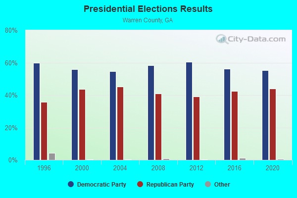
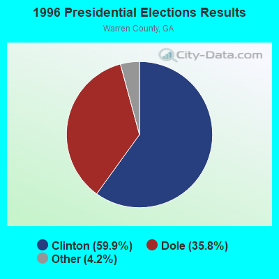
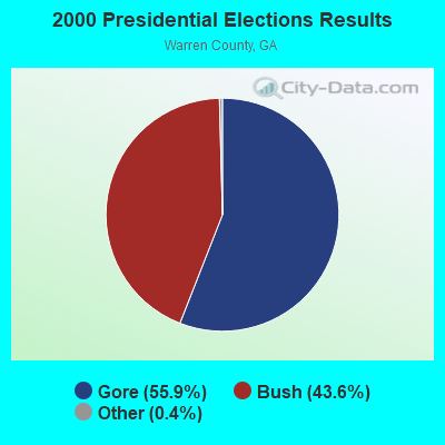


Graphs represent county-level data. Detailed 2008 Election Results
Religion statistics for Panhandle, GA (based on Warren County data)
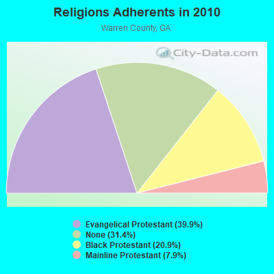
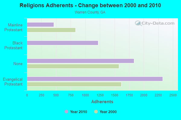
| Religion | Adherents | Congregations |
|---|---|---|
| Evangelical Protestant | 2,325 | 11 |
| Black Protestant | 1,220 | 9 |
| Mainline Protestant | 459 | 5 |
| None | 1,830 | - |
Food Environment Statistics:
| This county: | 1.70 / 10,000 pop. |
| Georgia: | 1.91 / 10,000 pop. |
| Warren County: | 5.10 / 10,000 pop. |
| Georgia: | 0.86 / 10,000 pop. |
| This county: | 5.10 / 10,000 pop. |
| State: | 5.12 / 10,000 pop. |
| This county: | 6.80 / 10,000 pop. |
| State: | 7.41 / 10,000 pop. |
| Warren County: | 14.2% |
| Georgia: | 10.4% |
| This county: | 32.0% |
| State: | 27.8% |
| This county: | 15.9% |
| State: | 14.6% |
Strongest AM radio stations in Panhandle:
- WGAC (580 AM; 5 kW; AUGUSTA, GA; Owner: WGAC LICENSE, LLC)
- WMAC (940 AM; 50 kW; MACON, GA; Owner: CUMULUS LICENSING CORP.)
- WRDW (1480 AM; 10 kW; AUGUSTA, GA; Owner: WCHZ LICENSE, LLC)
- WTEL (1630 AM; 10 kW; AUGUSTA, GA; Owner: WCHZ LICENSE, LLC)
- WTWA (1240 AM; 1 kW; THOMSON, GA; Owner: CAMELLIA CITY COMMUNICATIONS, INC.)
- WLFJ (660 AM; daytime; 50 kW; GREENVILLE, SC; Owner: CLEAR CHANNEL BROADCASTING LICENSES, INC.)
- WBAJ (890 AM; daytime; 50 kW; BLYTHEWOOD, SC; Owner: FAMILY FIRST)
- WCNN (680 AM; 50 kW; NORTH ATLANTA, GA; Owner: DICKEY BROADCASTING COMPANY)
- WSB (750 AM; 50 kW; ATLANTA, GA; Owner: CXR HOLDINGS, INC.)
- WGST (640 AM; 50 kW; ATLANTA, GA; Owner: CITICASTERS LICENSES, L.P.)
- WFAM (1050 AM; 5 kW; AUGUSTA, GA; Owner: J.J. & B. BROADCASTING, INC.)
- WCEO (840 AM; daytime; 50 kW; COLUMBIA, SC; Owner: EASTERN BROADCASTING GROUP, INC.)
- WGUN (1010 AM; 50 kW; ATLANTA, GA; Owner: WGUN, INC.)
Strongest FM radio stations in Panhandle:
- WAKB (96.9 FM; WRENS, GA; Owner: RADIO ONE OF AUGUSTA, LLC)
- WCHZ (95.1 FM; HARLEM, GA; Owner: WCHZ LICENSE,LLC)
- WTHO-FM (101.7 FM; THOMSON, GA; Owner: CAMELLIA CITY COMMUNICATIONS, INC.)
- WAFJ (88.3 FM; BELVEDERE, SC; Owner: RADIO TRAINING NETWORK, INC.)
- WRFN (93.1 FM; WARRENTON, GA; Owner: WCHZ LICENSE, LLC)
- WZNY (105.7 FM; AUGUSTA, GA; Owner: CAPSTAR TX LIMITED PARTNERSHIP)
- WPRW-FM (107.7 FM; MARTINEZ, GA; Owner: CAPSTAR TX LIMITED PARTNERSHIP)
- WBBQ-FM (104.3 FM; AUGUSTA, GA; Owner: CAPSTAR TX LIMITED PARTNERSHIP)
- WGOR (93.9 FM; MARTINEZ, GA; Owner: WGOR LICENSE, LLC)
- WQZY (95.9 FM; DUBLIN, GA; Owner: STATE BROADCASTING CORPORATION)
- WEKL (102.3 FM; AUGUSTA, GA; Owner: CAPSTAR TX LIMITED PARTNERSHIP)
- WKSP (96.3 FM; AIKEN, SC; Owner: CAPSTAR TX LIMITED PARTNERSHIP)
- WPEH-FM (92.1 FM; LOUISVILLE, GA; Owner: PEACH BROADCASTING CO., INC.)
- WAEG (92.3 FM; EVANS, GA; Owner: RADIO ONE OF AUGUSTA, LLC)
TV broadcast stations around Panhandle:
- WCES-TV (Channel 20; WRENS, GA; Owner: GEORGIA PUBLIC TELECOMMUNICATIONS COMMISSION)
- WJBF (Channel 6; AUGUSTA, GA; Owner: MEDIA GENERAL BROADCASTING OF SO. CAROLINA HOLDINGS, INC.)
- WAGT (Channel 26; AUGUSTA, GA; Owner: WAGT TELEVISION, INC.)
- WRDW-TV (Channel 12; AUGUSTA, GA; Owner: WRDW LICENSEE CORP.)
- WFXG (Channel 54; AUGUSTA, GA; Owner: FISHER BROADCASTING - GEORGIA, L.L.C.)
- WAAU-LP (Channel 18; AUGUSTA, GA; Owner: THOMAS J. PIPER)
- WBPI-LP (Channel 49; AUGUSTA, GA; Owner: WATCHMAN BROADCASTING PRODUCTIONS INTERNATIONAL, INC.)
- W58CZ (Channel 58; AUGUSTA, GA; Owner: TRINITY BROADCASTING NETWORK)
Panhandle compared to Georgia state average:
- Median household income below state average.
- Median house value below state average.
- Black race population percentage below state average.
- Hispanic race population percentage significantly below state average.
- Foreign-born population percentage significantly below state average.
- Length of stay since moving in significantly above state average.
- Number of rooms per house significantly below state average.
- House age significantly below state average.
- Percentage of population with a bachelor's degree or higher significantly below state average.