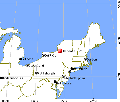
Osceola, New York
Submit your own pictures of this town and show them to the world
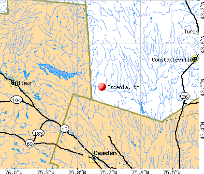
- OSM Map
- General Map
- Google Map
- MSN Map
Population change since 2000: -13.6%
 |
| Males: 118 | |
| Females: 111 |
| Median resident age: | 48.8 years |
| New York median age: | 40.7 years |
Zip codes: 13316.
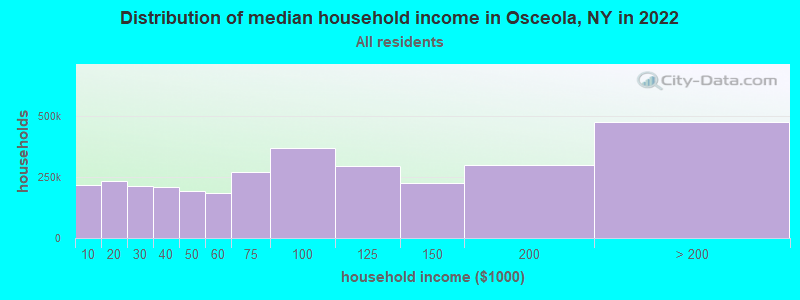
| Osceola: | $64,984 |
| NY: | $79,557 |
Estimated per capita income in 2022: $36,507 (it was $17,467 in 2000)
Osceola town income, earnings, and wages data
Estimated median house or condo value in 2022: $133,774 (it was $55,600 in 2000)
| Osceola: | $133,774 |
| NY: | $400,400 |
Mean prices in 2022: all housing units: $195,982; detached houses: $185,821; townhouses or other attached units: $343,653; in 2-unit structures: $649,528; in 3-to-4-unit structures: $681,838; in 5-or-more-unit structures: $414,780; mobile homes: $75,743
Detailed information about poverty and poor residents in Osceola, NY


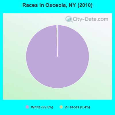
- 22899.6%White alone
- 10.4%Two or more races
Races in Osceola detailed stats: ancestries, foreign born residents, place of birth
 Recent articles from our blog. Our writers, many of them Ph.D. graduates or candidates, create easy-to-read articles on a wide variety of topics.

 | Tappan Zee bridge name change (34 replies) |
| Ate out at Arthur Avenue in the Bronx yesterday. (37 replies) |
| Relocating to PA, NY, VT, NH, or ME - any input? (8 replies) |
| Redfield and Osceola (0 replies) |
| Syracuse suburbs & outskirts -- opinions? (166 replies) |
| where is best place to get XC ski lesson on Friday in Rome/Utica area (1 reply) |
Latest news from Osceola, NY collected exclusively by city-data.com from local newspapers, TV, and radio stations
Ancestries: United States (18.1%), German (17.0%), Irish (17.0%), French (6.4%), Swiss (5.3%), Italian (4.9%).
Current Local Time: EST time zone
Land area: 87.0 square miles.
Population density: 2.6 people per square mile (very low).
6 residents are foreign born (1.1% Europe, 1.1% Asia).
| This town: | 2.3% |
| New York: | 20.4% |
| Osceola town: | 1.8% ($1,013) |
| New York: | 1.9% ($2,847) |
Nearest city with pop. 50,000+: Clay, NY  (36.4 miles , pop. 58,805).
Nearest city with pop. 200,000+: Rochester, NY (99.5 miles , pop. 219,773).
Nearest city with pop. 1,000,000+: Bronx, NY (208.2 miles , pop. 1,332,650).
Nearest cities:
), ), ), )Latitude: 43.54 N, Longitude: 75.70 W
Area code: 315

| Here: | 5.6% |
| New York: | 4.4% |
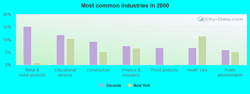
- Metal & metal products (15.3%)
- Educational services (11.9%)
- Construction (9.3%)
- Finance & insurance (7.6%)
- Wood products (6.8%)
- Health care (6.8%)
- Public administration (5.9%)
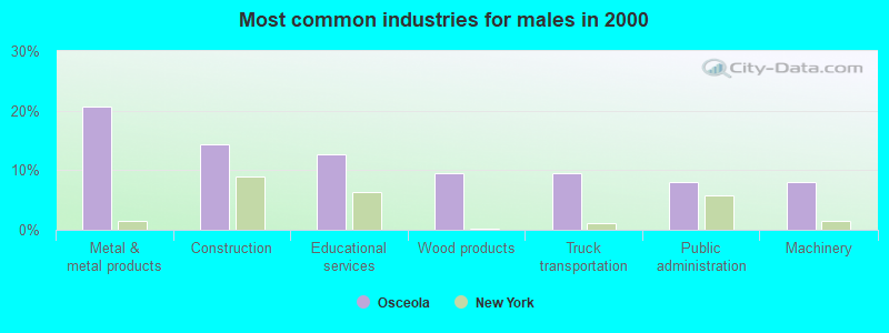
- Metal & metal products (20.6%)
- Construction (14.3%)
- Educational services (12.7%)
- Wood products (9.5%)
- Truck transportation (9.5%)
- Public administration (7.9%)
- Machinery (7.9%)
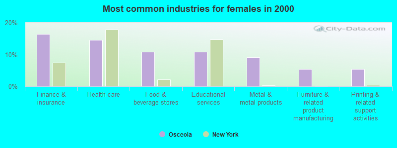
- Finance & insurance (16.4%)
- Health care (14.5%)
- Food & beverage stores (10.9%)
- Educational services (10.9%)
- Metal & metal products (9.1%)
- Furniture & related product manufacturing (5.5%)
- Printing & related support activities (5.5%)
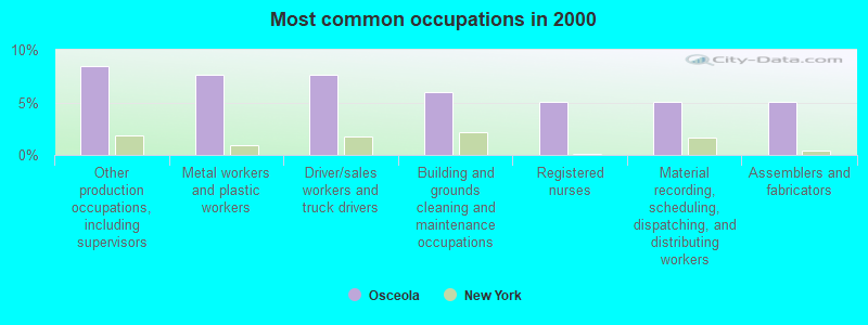
- Other production occupations, including supervisors (8.5%)
- Metal workers and plastic workers (7.6%)
- Driver/sales workers and truck drivers (7.6%)
- Building and grounds cleaning and maintenance occupations (5.9%)
- Registered nurses (5.1%)
- Material recording, scheduling, dispatching, and distributing workers (5.1%)
- Assemblers and fabricators (5.1%)
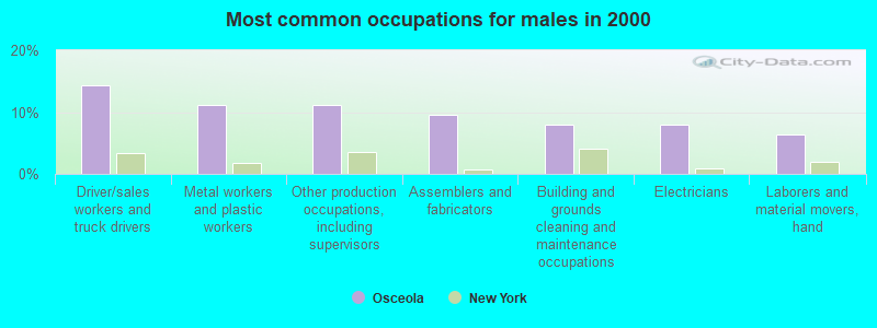
- Driver/sales workers and truck drivers (14.3%)
- Metal workers and plastic workers (11.1%)
- Other production occupations, including supervisors (11.1%)
- Assemblers and fabricators (9.5%)
- Building and grounds cleaning and maintenance occupations (7.9%)
- Electricians (7.9%)
- Laborers and material movers, hand (6.3%)
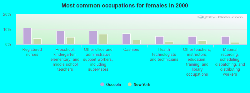
- Registered nurses (10.9%)
- Preschool, kindergarten, elementary, and middle school teachers (9.1%)
- Other office and administrative support workers, including supervisors (9.1%)
- Cashiers (7.3%)
- Health technologists and technicians (5.5%)
- Other teachers, instructors, education, training, and library occupations (5.5%)
- Material recording, scheduling, dispatching, and distributing workers (5.5%)
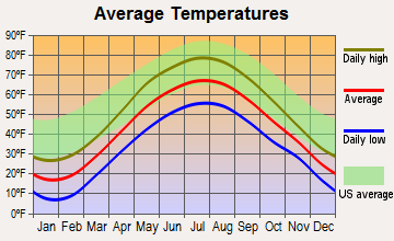
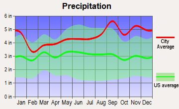
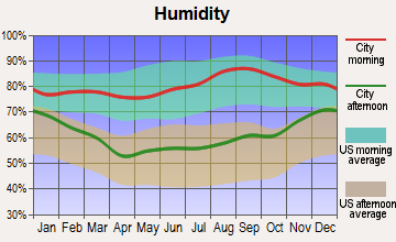
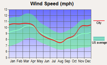
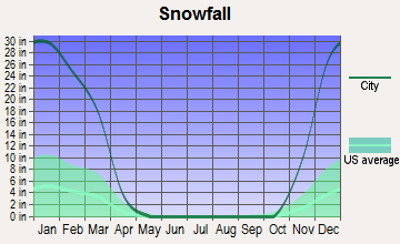
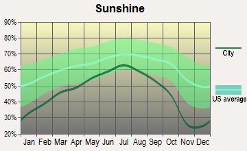
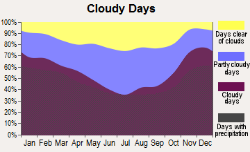
Average climate in Osceola, New York
Based on data reported by over 4,000 weather stations
Earthquake activity:
Osceola-area historical earthquake activity is significantly above New York state average. It is 69% smaller than the overall U.S. average.On 10/7/1983 at 10:18:46, a magnitude 5.3 (5.1 MB, 5.3 LG, 5.1 ML, Class: Moderate, Intensity: VI - VII) earthquake occurred 73.8 miles away from the city center
On 4/20/2002 at 10:50:47, a magnitude 5.3 (5.3 ML, Depth: 3.0 mi) earthquake occurred 120.4 miles away from Osceola center
On 4/20/2002 at 10:50:47, a magnitude 5.2 (5.2 MB, 4.2 MS, 5.2 MW, 5.0 MW) earthquake occurred 118.5 miles away from the city center
On 9/25/1998 at 19:52:52, a magnitude 5.2 (4.8 MB, 4.3 MS, 5.2 LG, 4.5 MW, Depth: 3.1 mi) earthquake occurred 278.0 miles away from Osceola center
On 6/17/1991 at 08:53:16, a magnitude 4.1 (4.0 MB, 4.0 LG, Depth: 3.1 mi, Class: Light, Intensity: IV - V) earthquake occurred 81.2 miles away from the city center
On 1/19/1982 at 00:14:42, a magnitude 4.7 (4.5 MB, 4.7 MD, 4.5 LG) earthquake occurred 205.6 miles away from the city center
Magnitude types: regional Lg-wave magnitude (LG), body-wave magnitude (MB), duration magnitude (MD), local magnitude (ML), surface-wave magnitude (MS), moment magnitude (MW)
Natural disasters:
The number of natural disasters in Lewis County (21) is greater than the US average (15).Major Disasters (Presidential) Declared: 11
Emergencies Declared: 9
Causes of natural disasters: Floods: 7, Storms: 7, Winter Storms: 4, Snowstorms: 3, Hurricanes: 2, Snows: 2, Winds: 2, Blizzard: 1, Power Outage: 1, Tornado: 1, Other: 2 (Note: some incidents may be assigned to more than one category).
Colleges/universities with over 2000 students nearest to Osceola:
- Jefferson Community College (about 34 miles; Watertown, NY; Full-time enrollment: 2,886)
- Utica College (about 38 miles; Utica, NY; FT enrollment: 2,952)
- Le Moyne College (about 40 miles; Syracuse, NY; FT enrollment: 3,041)
- Mohawk Valley Community College (about 40 miles; Utica, NY; FT enrollment: 5,693)
- Syracuse University (about 41 miles; Syracuse, NY; FT enrollment: 20,717)
- SUNY College of Environmental Science and Forestry (about 42 miles; Syracuse, NY; FT enrollment: 2,044)
- SUNY College at Oswego (about 43 miles; Oswego, NY; FT enrollment: 7,550)
Points of interest:
Notable location: Osceola Public Library (A). Display/hide its location on the map
Cemeteries: Salmon River Cemetery (1), Gregory Cemetery (2). Display/hide their locations on the map
Reservoir: Stone Pond (A). Display/hide its location on the map
Streams, rivers, and creeks: Smith Brook (A), Fall Brook (B), Roaring Brook (C), Deep Creek (D), Crooked Brook (E), Cowles Creek (F), Baker Brook (G), Threemile Creek (H), Pickens Brook (I). Display/hide their locations on the map
Birthplace of: Vince Dailey - Baseball player.
| This town: | 2.2 people |
| New York: | 2.6 people |
| This town: | 58.3% |
| Whole state: | 63.5% |
| This town: | 12.6% |
| Whole state: | 6.8% |
Likely homosexual households (counted as self-reported same-sex unmarried-partner households)
- Lesbian couples: 1.0% of all households
- Gay men: 1.0% of all households
| This town: | 12.2% |
| Whole state: | 14.6% |
| This town: | 8.6% |
| Whole state: | 7.4% |
For population 15 years and over in Osceola:
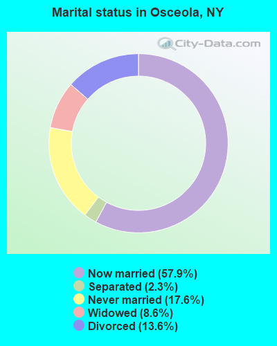
- Never married: 17.6%
- Now married: 57.9%
- Separated: 2.3%
- Widowed: 8.6%
- Divorced: 13.6%
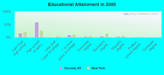
For population 25 years and over in Osceola:
- High school or higher: 83.1%
- Bachelor's degree or higher: 9.2%
- Graduate or professional degree: 4.3%
- Unemployed: 11.9%
- Mean travel time to work (commute): 35.2 minutes
| Here: | 8.4 |
| New York average: | 14.2 |
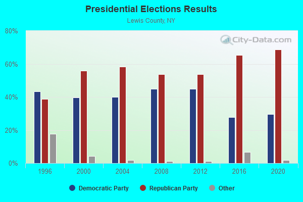
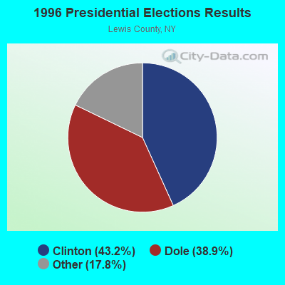
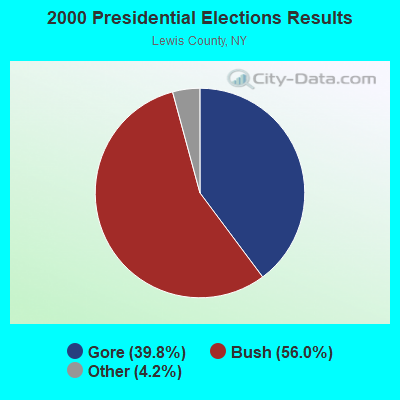
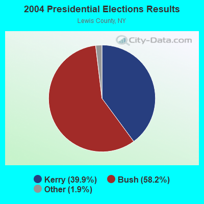
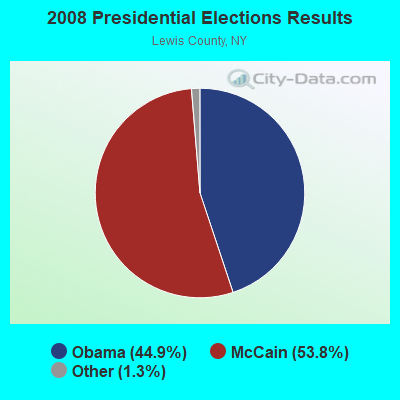
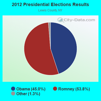
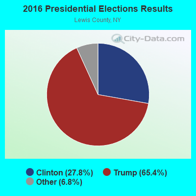
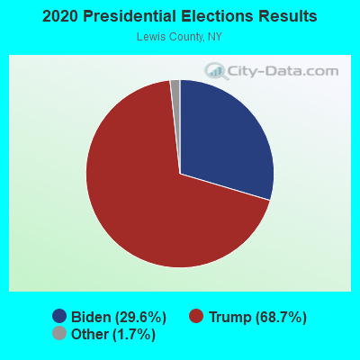
Graphs represent county-level data. Detailed 2008 Election Results
Religion statistics for Osceola, NY (based on Lewis County data)
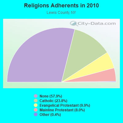
| Religion | Adherents | Congregations |
|---|---|---|
| Catholic | 6,443 | 17 |
| Evangelical Protestant | 2,693 | 21 |
| Mainline Protestant | 2,155 | 25 |
| Other | 115 | 1 |
| None | 15,681 | - |
Food Environment Statistics:
| This county: | 3.41 / 10,000 pop. |
| New York: | 4.13 / 10,000 pop. |
| This county: | 4.92 / 10,000 pop. |
| State: | 1.68 / 10,000 pop. |
| Here: | 10.61 / 10,000 pop. |
| New York: | 8.82 / 10,000 pop. |
| This county: | 9.6% |
| New York: | 8.2% |
| Lewis County: | 27.4% |
| New York: | 23.8% |
| Lewis County: | 13.4% |
| State: | 15.6% |
Strongest AM radio stations in Osceola:
- WGY (810 AM; 50 kW; SCHENECTADY, NY; Owner: CLEAR CHANNEL BROADCASTING LICENSES, INC.)
- WHEN (620 AM; 5 kW; SYRACUSE, NY; Owner: CLEAR CHANNEL BROADCASTING LICENSES, INC.)
- WSCP (1070 AM; daytime; 2 kW; SANDY CREEK-PULASKI, NY; Owner: GALAXY COMMUNICATIONS, L.P.)
- WRUN (1150 AM; 5 kW; UTICA, NY)
- WIBX (950 AM; 5 kW; UTICA, NY; Owner: REGENT LICENSEE OF UTICA/ROME, INC.)
- WSYR (570 AM; 5 kW; SYRACUSE, NY; Owner: CLEAR CHANNEL BROADCASTING LICENSES, INC.)
- WNER (1410 AM; 5 kW; WATERTOWN, NY)
- WADR (1480 AM; 5 kW; REMSEN, NY; Owner: CLEAR CHANNEL BROADCASTING LICENSES, INC.)
- WBRV (900 AM; 1 kW; BOONVILLE, NY)
- WHAM (1180 AM; 50 kW; ROCHESTER, NY; Owner: CITICASTERS LICENSES, L.P.)
- WPTR (1540 AM; 50 kW; ALBANY, NY; Owner: KIMTRON, INC.)
- WDCW (1390 AM; 5 kW; SYRACUSE, NY; Owner: KIMTRON, INC.)
- WNSS (1260 AM; 5 kW; SYRACUSE, NY; Owner: CITADEL BROADCASTING COMPANY)
Strongest FM radio stations in Osceola:
- WJNY (90.9 FM; WATERTOWN, NY; Owner: PUBLIC B/CNG COUNCIL CENTRAL NY, INC)
- WBDI (106.7 FM; COPENHAGEN, NY; Owner: FORCE COMMUNICATIONS, INC)
- WLLG (99.3 FM; LOWVILLE, NY; Owner: THE FLACK BROADCASTING GROUP L.L.C.)
- WSCP-FM (101.7 FM; PULASKI, NY; Owner: GALAXY COMMUNICATIONS, L.P.)
- WFRY-FM (97.5 FM; WATERTOWN, NY; Owner: REGENT LICENSEE OF WATERTOWN, INC.)
- WUCL (93.5 FM; REMSEN, NY; Owner: CLEAR CHANNEL BROADCASTING LICENSES, INC.)
- WODZ-FM (96.1 FM; ROME, NY; Owner: REGENT LICENSEE OF UTICA/ROME, INC.)
- WTOJ (103.1 FM; CARTHAGE, NY; Owner: CLANCY-MANCE COMMUNICATIONS, INC.)
- WBRV-FM (101.3 FM; BOONVILLE, NY; Owner: THE FLACK BROADCASTING GROUP L.L.C.)
- WMCR-FM (106.3 FM; ONEIDA, NY; Owner: WARREN BROADCASTING CO. INC.)
- WBGJ (100.3 FM; SYLVAN BEACH, NY; Owner: WOLF RADIO, INC.)
- WOUR (96.9 FM; UTICA, NY; Owner: CLEAR CHANNEL BROADCASTING LICENSES, INC.)
- WUNY (89.5 FM; UTICA, NY; Owner: PUBLIC BC COUNCIL OF CENTRAL NY, INC)
- WWJS (90.1 FM; WATERTOWN, NY; Owner: LIBERTY COMMUNICATIONS FAMILY B/G)
- WSLJ (88.9 FM; WATERTOWN, NY; Owner: THE ST. LAWRENCE UNIVERSITY)
TV broadcast stations around Osceola:
- WSPX-TV (Channel 56; SYRACUSE, NY; Owner: PAXSON SYRACUSE LICENSE, INC.)
- WPBS-TV (Channel 16; WATERTOWN, NY; Owner: ST. LAWRENCE VALLEY EDUCATIONAL TV COUNCIL, INC)
- WWTI (Channel 50; WATERTOWN, NY; Owner: CENTRAL NY NEWS, INC.)
- WFXV (Channel 33; UTICA, NY; Owner: QUORUM OF UTICA LICENSE, LLC)
- WWNY-TV (Channel 7; CARTHAGE, NY; Owner: UNITED COMMUNICATIONS CORPORATION)
- WCNY-TV (Channel 24; SYRACUSE, NY; Owner: PUBLIC BROADCASTING COUNCIL OF CENTRAL NEW YORK)
- WNYS-TV (Channel 43; SYRACUSE, NY; Owner: RKM MEDIA, INC.)
- National Bridge Inventory (NBI) Statistics
- 8Number of bridges
- 39ft / 11.7mTotal length
- $2,653,000Total costs
- 714Total average daily traffic
- 34Total average daily truck traffic
- 999Total future (year 2034) average daily traffic
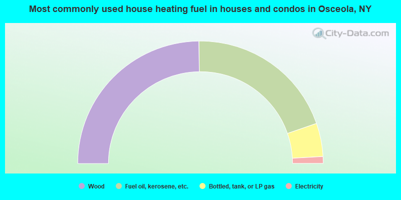
- 49.6%Wood
- 39.8%Fuel oil, kerosene, etc.
- 8.8%Bottled, tank, or LP gas
- 1.8%Electricity
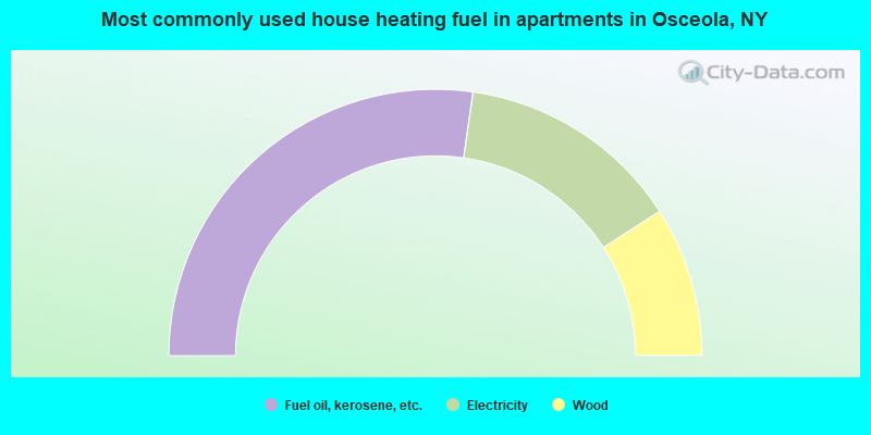
- 54.5%Fuel oil, kerosene, etc.
- 27.3%Electricity
- 18.2%Wood
Osceola compared to New York state average:
- Median house value significantly below state average.
- Black race population percentage significantly below state average.
- Hispanic race population percentage significantly below state average.
- Median age significantly above state average.
- Foreign-born population percentage significantly below state average.
- Renting percentage significantly below state average.
- Length of stay since moving in significantly above state average.
- Number of rooms per house significantly below state average.
- House age significantly below state average.
- Number of college students significantly below state average.
- Percentage of population with a bachelor's degree or higher significantly below state average.