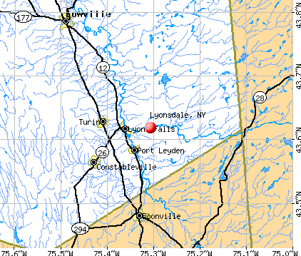
Lyonsdale, New York
Submit your own pictures of this town and show them to the world
- OSM Map
- General Map
- Google Map
- MSN Map
Population change since 2000: -3.6%
 |
| Males: 612 | |
| Females: 615 |
| Median resident age: | 40.5 years |
| New York median age: | 40.7 years |
Zip codes: 13433.
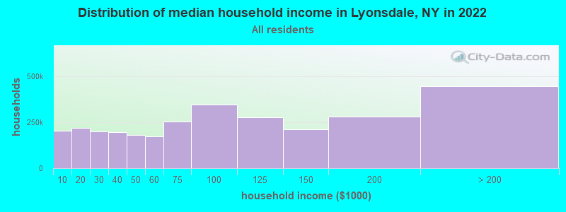
| Lyonsdale: | $61,048 |
| NY: | $79,557 |
Estimated per capita income in 2022: $27,794 (it was $13,298 in 2000)
Lyonsdale town income, earnings, and wages data
Estimated median house or condo value in 2022: $104,180 (it was $43,300 in 2000)
| Lyonsdale: | $104,180 |
| NY: | $400,400 |
Mean prices in 2022: all housing units: $195,982; detached houses: $185,821; townhouses or other attached units: $343,653; in 2-unit structures: $649,528; in 3-to-4-unit structures: $681,838; in 5-or-more-unit structures: $414,780; mobile homes: $75,743
Detailed information about poverty and poor residents in Lyonsdale, NY


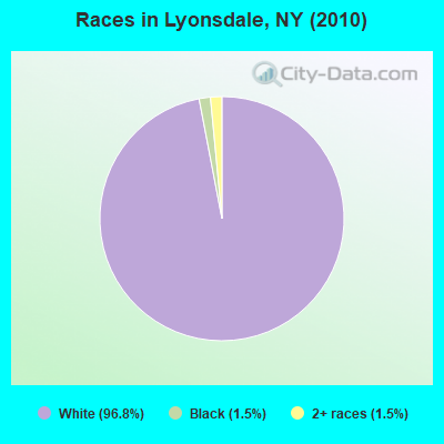
- 1,18896.8%White alone
- 191.5%Black alone
- 191.5%Two or more races
- 10.08%Hispanic
Races in Lyonsdale detailed stats: ancestries, foreign born residents, place of birth
 Recent articles from our blog. Our writers, many of them Ph.D. graduates or candidates, create easy-to-read articles on a wide variety of topics.

 | Relocating to PA, NY, VT, NH, or ME - any input? (8 replies) |
Latest news from Lyonsdale, NY collected exclusively by city-data.com from local newspapers, TV, and radio stations
Ancestries: German (24.4%), French (22.3%), Irish (19.1%), English (13.2%), United States (7.8%), Dutch (4.8%).
Current Local Time: EST time zone
Elevation: 1072 feet
Land area: 68.8 square miles.
Population density: 18 people per square mile (very low).
10 residents are foreign born
| This town: | 0.8% |
| New York: | 20.4% |
| Lyonsdale town: | 1.7% ($721) |
| New York: | 1.9% ($2,847) |
Nearest city with pop. 50,000+: Utica, NY  (35.2 miles , pop. 60,651).
Nearest city with pop. 200,000+: Rochester, NY (120.0 miles , pop. 219,773).
Nearest city with pop. 1,000,000+: Bronx, NY (204.1 miles , pop. 1,332,650).
Nearest cities:
), ), ), ), ), Latitude: 43.60 N, Longitude: 75.30 W
Area code commonly used in this area: 315

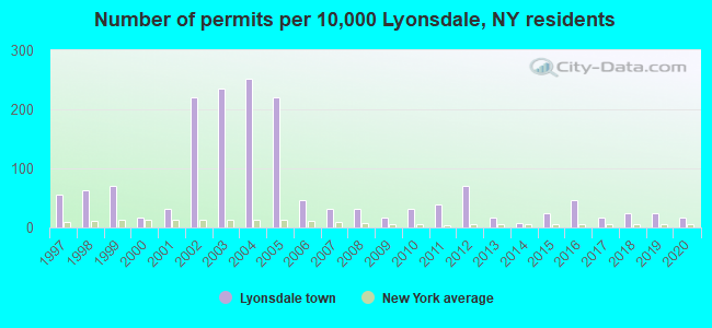
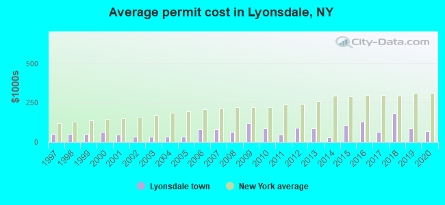
Single-family new house construction building permits:
- 2020: 2 buildings, average cost: $70,500
- 2019: 3 buildings, average cost: $88,300
- 2018: 3 buildings, average cost: $181,700
- 2017: 2 buildings, average cost: $62,500
- 2016: 6 buildings, average cost: $132,200
- 2015: 3 buildings, average cost: $110,000
- 2014: 1 building, cost: $30,000
- 2013: 2 buildings, average cost: $87,500
- 2012: 9 buildings, average cost: $92,800
- 2011: 5 buildings, average cost: $49,000
- 2010: 4 buildings, average cost: $86,300
- 2009: 2 buildings, average cost: $120,000
- 2008: 4 buildings, average cost: $62,500
- 2007: 4 buildings, average cost: $83,900
- 2006: 6 buildings, average cost: $83,900
- 2005: 28 buildings, average cost: $33,600
- 2004: 32 buildings, average cost: $33,600
- 2003: 30 buildings, average cost: $33,600
- 2002: 28 buildings, average cost: $33,600
- 2001: 4 buildings, average cost: $46,300
- 2000: 2 buildings, average cost: $63,900
- 1999: 9 buildings, average cost: $53,900
- 1998: 8 buildings, average cost: $53,900
- 1997: 7 buildings, average cost: $53,900
| Here: | 5.6% |
| New York: | 4.4% |
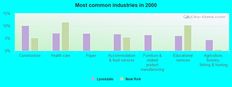
- Construction (10.1%)
- Health care (7.1%)
- Paper (6.9%)
- Accommodation & food services (6.8%)
- Furniture & related product manufacturing (6.4%)
- Educational services (6.0%)
- Agriculture, forestry, fishing & hunting (4.4%)
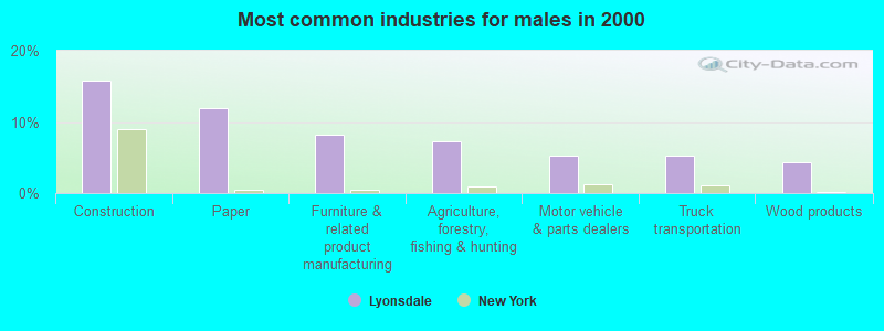
- Construction (15.8%)
- Paper (11.9%)
- Furniture & related product manufacturing (8.3%)
- Agriculture, forestry, fishing & hunting (7.3%)
- Motor vehicle & parts dealers (5.3%)
- Truck transportation (5.3%)
- Wood products (4.3%)
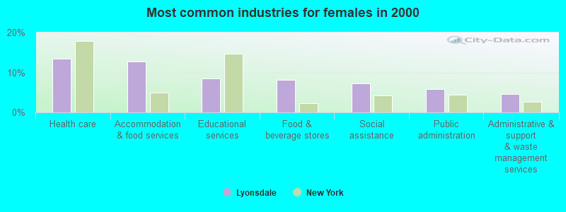
- Health care (13.5%)
- Accommodation & food services (12.7%)
- Educational services (8.5%)
- Food & beverage stores (8.1%)
- Social assistance (7.3%)
- Public administration (5.8%)
- Administrative & support & waste management services (4.6%)
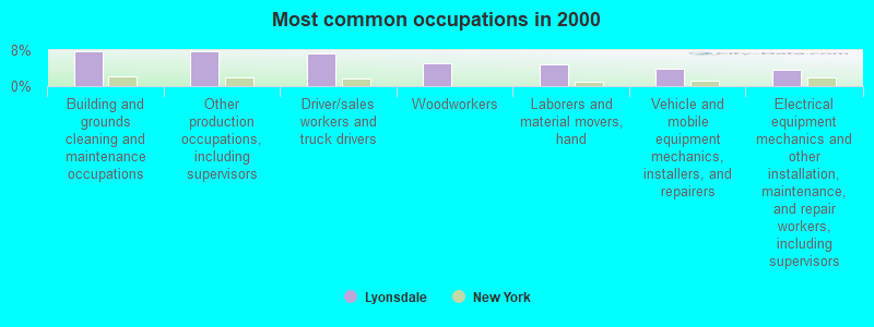
- Building and grounds cleaning and maintenance occupations (7.8%)
- Other production occupations, including supervisors (7.8%)
- Driver/sales workers and truck drivers (7.3%)
- Woodworkers (5.0%)
- Laborers and material movers, hand (4.8%)
- Vehicle and mobile equipment mechanics, installers, and repairers (3.9%)
- Electrical equipment mechanics and other installation, maintenance, and repair workers, including supervisors (3.7%)
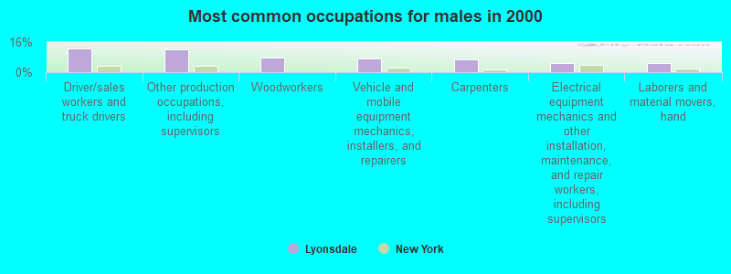
- Driver/sales workers and truck drivers (12.5%)
- Other production occupations, including supervisors (12.2%)
- Woodworkers (7.6%)
- Vehicle and mobile equipment mechanics, installers, and repairers (7.3%)
- Carpenters (6.9%)
- Electrical equipment mechanics and other installation, maintenance, and repair workers, including supervisors (5.0%)
- Laborers and material movers, hand (5.0%)
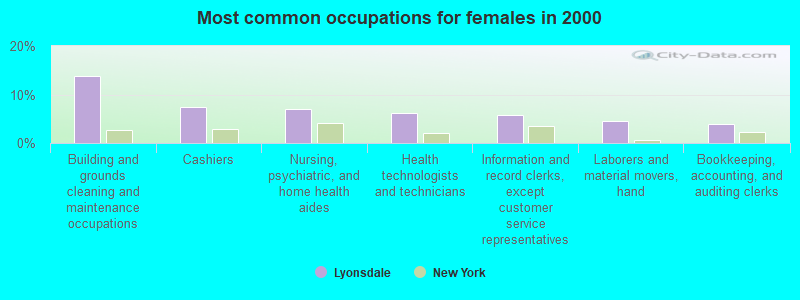
- Building and grounds cleaning and maintenance occupations (13.9%)
- Cashiers (7.3%)
- Nursing, psychiatric, and home health aides (6.9%)
- Health technologists and technicians (6.2%)
- Information and record clerks, except customer service representatives (5.8%)
- Laborers and material movers, hand (4.6%)
- Bookkeeping, accounting, and auditing clerks (3.9%)
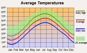
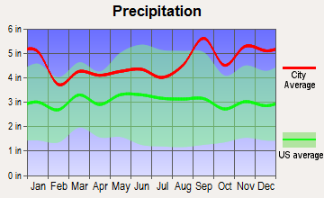
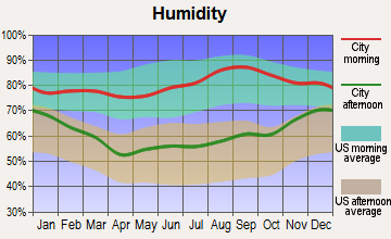
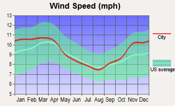
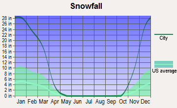
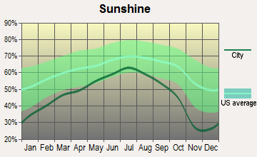
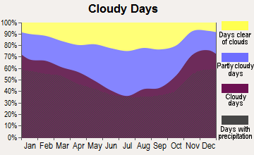
Average climate in Lyonsdale, New York
Based on data reported by over 4,000 weather stations
(lower is better)
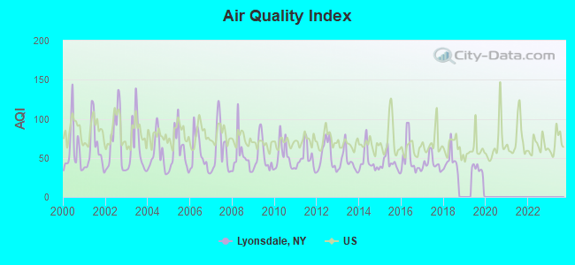
Air Quality Index (AQI) level in 2019 was 32.1. This is significantly better than average.
| City: | 32.1 |
| U.S.: | 72.6 |
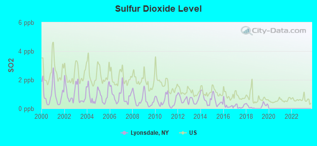
Sulfur Dioxide (SO2) [ppb] level in 2019 was 0.271. This is significantly better than average. Closest monitor was 16.8 miles away from the city center.
| City: | 0.271 |
| U.S.: | 1.515 |

Ozone [ppb] level in 2019 was 20.8. This is significantly better than average. Closest monitor was 16.8 miles away from the city center.
| City: | 20.8 |
| U.S.: | 33.3 |
Earthquake activity:
Lyonsdale-area historical earthquake activity is significantly above New York state average. It is 69% smaller than the overall U.S. average.On 10/7/1983 at 10:18:46, a magnitude 5.3 (5.1 MB, 5.3 LG, 5.1 ML, Class: Moderate, Intensity: VI - VII) earthquake occurred 53.7 miles away from the city center
On 4/20/2002 at 10:50:47, a magnitude 5.3 (5.3 ML, Depth: 3.0 mi) earthquake occurred 101.6 miles away from the city center
On 4/20/2002 at 10:50:47, a magnitude 5.2 (5.2 MB, 4.2 MS, 5.2 MW, 5.0 MW) earthquake occurred 99.7 miles away from the city center
On 1/19/1982 at 00:14:42, a magnitude 4.7 (4.5 MB, 4.7 MD, 4.5 LG, Class: Light, Intensity: IV - V) earthquake occurred 185.7 miles away from the city center
On 6/17/1991 at 08:53:16, a magnitude 4.1 (4.0 MB, 4.0 LG, Depth: 3.1 mi) earthquake occurred 74.3 miles away from the city center
On 9/25/1998 at 19:52:52, a magnitude 5.2 (4.8 MB, 4.3 MS, 5.2 LG, 4.5 MW, Depth: 3.1 mi) earthquake occurred 297.8 miles away from the city center
Magnitude types: regional Lg-wave magnitude (LG), body-wave magnitude (MB), duration magnitude (MD), local magnitude (ML), surface-wave magnitude (MS), moment magnitude (MW)
Natural disasters:
The number of natural disasters in Lewis County (21) is greater than the US average (15).Major Disasters (Presidential) Declared: 11
Emergencies Declared: 9
Causes of natural disasters: Floods: 7, Storms: 7, Winter Storms: 4, Snowstorms: 3, Hurricanes: 2, Snows: 2, Winds: 2, Blizzard: 1, Power Outage: 1, Tornado: 1, Other: 2 (Note: some incidents may be assigned to more than one category).
Colleges/universities with over 2000 students nearest to Lyonsdale:
- Utica College (about 36 miles; Utica, NY; Full-time enrollment: 2,952)
- Mohawk Valley Community College (about 37 miles; Utica, NY; FT enrollment: 5,693)
- Jefferson Community College (about 42 miles; Watertown, NY; FT enrollment: 2,886)
- Herkimer County Community College (about 43 miles; Herkimer, NY; FT enrollment: 2,774)
- Morrisville State College (about 52 miles; Morrisville, NY; FT enrollment: 2,823)
- Le Moyne College (about 56 miles; Syracuse, NY; FT enrollment: 3,041)
- Colgate University (about 56 miles; Hamilton, NY; FT enrollment: 3,094)
Points of interest:
Notable location: Porters Corners (A). Display/hide its location on the map
Churches in Lyonsdale include: Fisher Memorial Chapel (A), Gould Memorial Chapel (B), New Covenant Church (C). Display/hide their locations on the map
Cemeteries: Wildwood Cemetery (1), Calvary Cemetery (2). Display/hide their locations on the map
Lakes: Twin Sister Lake (A), Barnes Lake (B). Display/hide their locations on the map
Streams, rivers, and creeks: Beauty Creek (A), Pine Creek (B), Twin Sister Creek (C), Stony Creek (D), Fall Brook (E), Copper Creek (F), Black Creek (G), Cold Brook (H), Moose River (I). Display/hide their locations on the map
Park in Lyonsdale: Sand Flats State Park (1). Display/hide its location on the map
| This town: | 2.5 people |
| New York: | 2.6 people |
| This town: | 67.2% |
| Whole state: | 63.5% |
| This town: | 11.5% |
| Whole state: | 6.8% |
Likely homosexual households (counted as self-reported same-sex unmarried-partner households)
- Lesbian couples: 0.4% of all households
- Gay men: 0.4% of all households
| This town: | 20.0% |
| Whole state: | 14.6% |
| This town: | 3.8% |
| Whole state: | 7.4% |
For population 15 years and over in Lyonsdale:
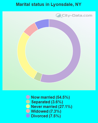
- Never married: 27.1%
- Now married: 54.5%
- Separated: 3.6%
- Widowed: 7.3%
- Divorced: 7.5%
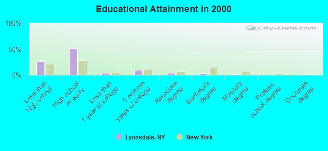
For population 25 years and over in Lyonsdale:
- High school or higher: 73.6%
- Bachelor's degree or higher: 4.4%
- Graduate or professional degree: 1.5%
- Unemployed: 11.2%
- Mean travel time to work (commute): 25.3 minutes
| Here: | 9.0 |
| New York average: | 14.2 |
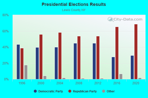
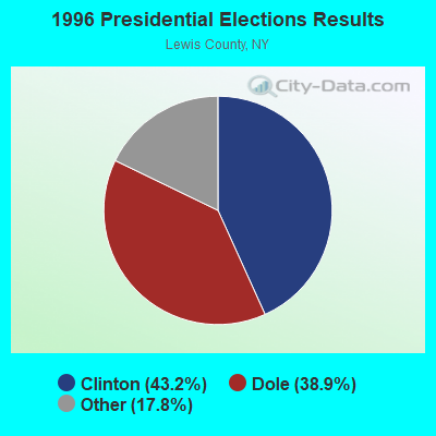
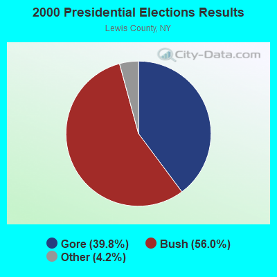
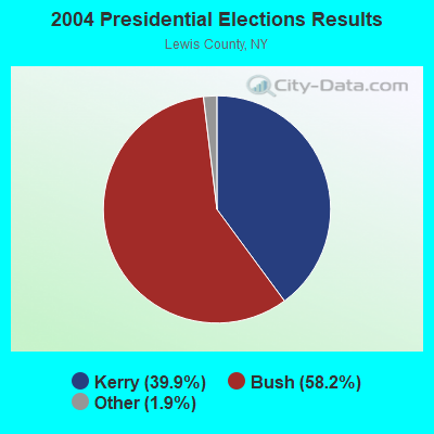
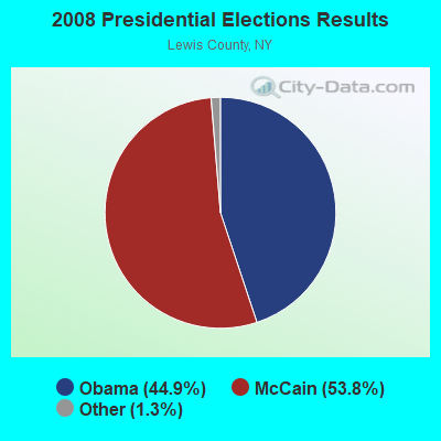
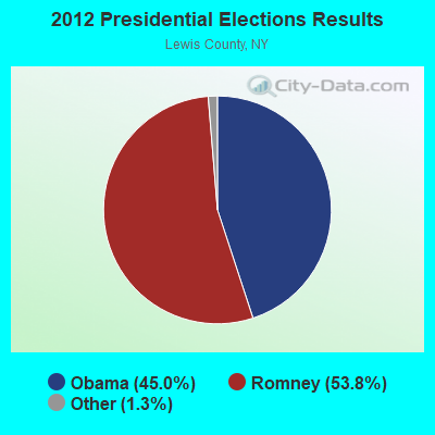
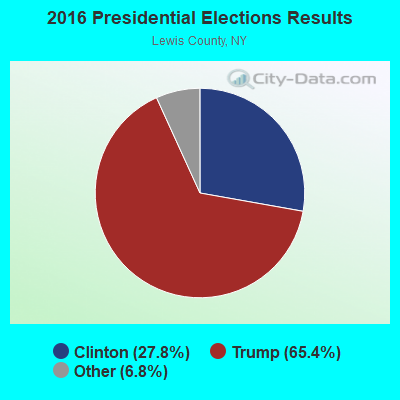
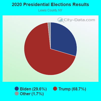
Graphs represent county-level data. Detailed 2008 Election Results
Religion statistics for Lyonsdale, NY (based on Lewis County data)
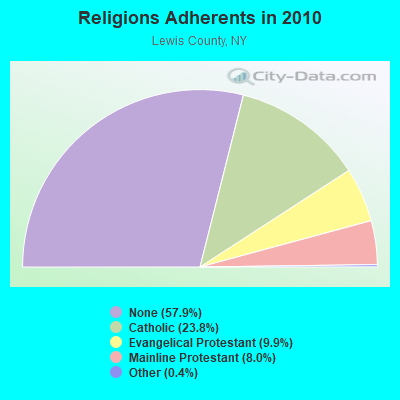
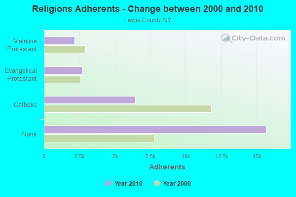
| Religion | Adherents | Congregations |
|---|---|---|
| Catholic | 6,443 | 17 |
| Evangelical Protestant | 2,693 | 21 |
| Mainline Protestant | 2,155 | 25 |
| Other | 115 | 1 |
| None | 15,681 | - |
Food Environment Statistics:
| Lewis County: | 3.41 / 10,000 pop. |
| New York: | 4.13 / 10,000 pop. |
| Lewis County: | 4.92 / 10,000 pop. |
| New York: | 1.68 / 10,000 pop. |
| Here: | 10.61 / 10,000 pop. |
| New York: | 8.82 / 10,000 pop. |
| Lewis County: | 9.6% |
| New York: | 8.2% |
| Lewis County: | 27.4% |
| State: | 23.8% |
| Lewis County: | 13.4% |
| New York: | 15.6% |
Strongest AM radio stations in Lyonsdale:
- WBRV (900 AM; 1 kW; BOONVILLE, NY)
- WADR (1480 AM; 5 kW; REMSEN, NY; Owner: CLEAR CHANNEL BROADCASTING LICENSES, INC.)
- WGY (810 AM; 50 kW; SCHENECTADY, NY; Owner: CLEAR CHANNEL BROADCASTING LICENSES, INC.)
- WRUN (1150 AM; 5 kW; UTICA, NY)
- WIBX (950 AM; 5 kW; UTICA, NY; Owner: REGENT LICENSEE OF UTICA/ROME, INC.)
- WPTR (1540 AM; 50 kW; ALBANY, NY; Owner: KIMTRON, INC.)
- WICY (1490 AM; 50 kW; MALONE, NY; Owner: CARTIER COMMUNICATIONS INC.)
- WNNZ (640 AM; 50 kW; WESTFIELD, MA; Owner: CLEAR CHANNEL BROADCASTING LICENSES, INC.)
- WTLB (1310 AM; 5 kW; UTICA, NY; Owner: GALAXY COMMUNICATIONS, L.P.)
- WHAM (1180 AM; 50 kW; ROCHESTER, NY; Owner: CITICASTERS LICENSES, L.P.)
- WCHP (760 AM; 35 kW; CHAMPLAIN, NY; Owner: CHAMPLAIN RADIO, INC.)
- WNER (1410 AM; 5 kW; WATERTOWN, NY)
- WHEN (620 AM; 5 kW; SYRACUSE, NY; Owner: CLEAR CHANNEL BROADCASTING LICENSES, INC.)
Strongest FM radio stations in Lyonsdale:
- WUCL (93.5 FM; REMSEN, NY; Owner: CLEAR CHANNEL BROADCASTING LICENSES, INC.)
- WBDI (106.7 FM; COPENHAGEN, NY; Owner: FORCE COMMUNICATIONS, INC)
- WBRV-FM (101.3 FM; BOONVILLE, NY; Owner: THE FLACK BROADCASTING GROUP L.L.C.)
- WJNY (90.9 FM; WATERTOWN, NY; Owner: PUBLIC B/CNG COUNCIL CENTRAL NY, INC)
- WLLG (99.3 FM; LOWVILLE, NY; Owner: THE FLACK BROADCASTING GROUP L.L.C.)
- WXLH (91.3 FM; BLUE MOUNTAIN LAKE, NY; Owner: THE ST. LAWRENCE UNIVERSITY)
- WFRY-FM (97.5 FM; WATERTOWN, NY; Owner: REGENT LICENSEE OF WATERTOWN, INC.)
- WXLG (89.9 FM; NORTH CREEK, NY; Owner: THE ST. LAWRENCE UNIVERSITY)
- WOUR (96.9 FM; UTICA, NY; Owner: CLEAR CHANNEL BROADCASTING LICENSES, INC.)
- WUNY (89.5 FM; UTICA, NY; Owner: PUBLIC BC COUNCIL OF CENTRAL NY, INC)
- WODZ-FM (96.1 FM; ROME, NY; Owner: REGENT LICENSEE OF UTICA/ROME, INC.)
- WLZW (98.7 FM; UTICA, NY; Owner: REGENT LICENSEE OF UTICA/ROME, INC.)
- WTOJ (103.1 FM; CARTHAGE, NY; Owner: CLANCY-MANCE COMMUNICATIONS, INC.)
- WBGK (99.7 FM; NEWPORT VILLAGE, NY; Owner: ROSER COMMUNICATIONS NETWORK, INC.)
- W206BH (89.1 FM; LYONS FALLS, NY; Owner: THE ST. LAWRENCE UNIVERSITY)
- W213AR (90.5 FM; LYONS FALLS, NY; Owner: BLACK RIVER VALLEY GOSPEL RADIO, INC)
- WKVU (100.7 FM; UTICA, NY; Owner: EDUCATIONAL MEDIA FOUNDATION)
- WKLL (94.9 FM; FRANKFORT, NY; Owner: GALAXY COMMUNICATIONS, L.P.)
TV broadcast stations around Lyonsdale:
- WWTI (Channel 50; WATERTOWN, NY; Owner: CENTRAL NY NEWS, INC.)
- WPBS-TV (Channel 16; WATERTOWN, NY; Owner: ST. LAWRENCE VALLEY EDUCATIONAL TV COUNCIL, INC)
- WKTV (Channel 2; UTICA, NY; Owner: SMITH TELEVISION OF NEW YORK LICENSE HOLDINGS, INC.)
- WSPX-TV (Channel 56; SYRACUSE, NY; Owner: PAXSON SYRACUSE LICENSE, INC.)
- WFXV (Channel 33; UTICA, NY; Owner: QUORUM OF UTICA LICENSE, LLC)
- WWNY-TV (Channel 7; CARTHAGE, NY; Owner: UNITED COMMUNICATIONS CORPORATION)
- National Bridge Inventory (NBI) Statistics
- 8Number of bridges
- 69ft / 20.7mTotal length
- $7,904,000Total costs
- 665Total average daily traffic
- 43Total average daily truck traffic
- 929Total future (year 2031) average daily traffic
FCC Registered Cell Phone Towers:
1 (See the full list of FCC Registered Cell Phone Towers in Lyonsdale)FCC Registered Antenna Towers:
15 (See the full list of FCC Registered Antenna Towers)FCC Registered Microwave Towers:
1- LYONSDALE, Wildcat Road (Lat: 43.572694 Lon: -75.300194), Type: Tower, Structure height: 85.3 m, Overall height: 89 m, Call Sign: WQPA302,
Assigned Frequencies: 11285.0 MHz, Grant Date: 03/19/2012, Expiration Date: 03/19/2022, Cancellation Date: 10/02/2018, Certifier: Chris Harris, Registrant: Conterra Ultra Broadband, LLC, 2101 Rexford Rd, Ste 200e, Charlotte, NC 28211, Phone: (704) 936-1801, Fax: (704) 936-1801, Email:
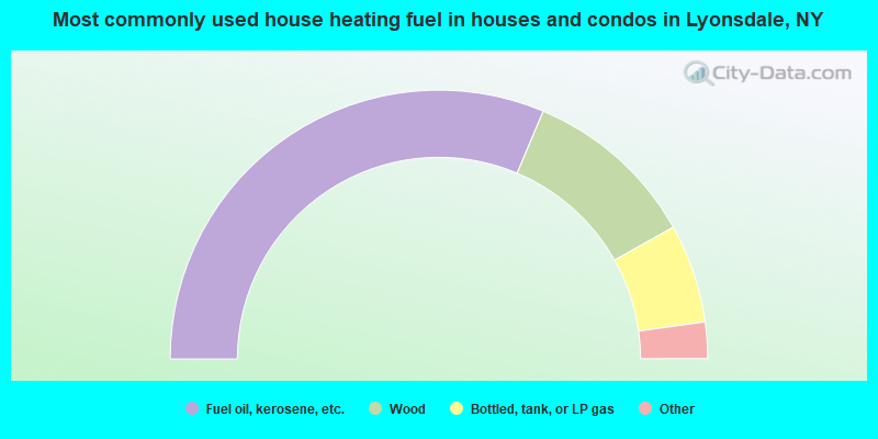
- 62.7%Fuel oil, kerosene, etc.
- 21.0%Wood
- 11.9%Bottled, tank, or LP gas
- 2.3%Electricity
- 1.8%Utility gas
- 0.3%Coal or coke
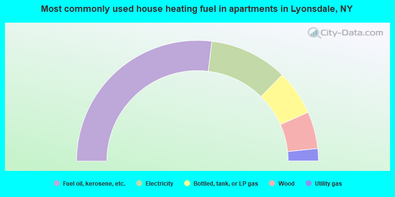
- 53.8%Fuel oil, kerosene, etc.
- 20.9%Electricity
- 12.1%Bottled, tank, or LP gas
- 9.9%Wood
- 3.3%Utility gas
Lyonsdale compared to New York state average:
- Median house value significantly below state average.
- Black race population percentage significantly below state average.
- Hispanic race population percentage significantly below state average.
- Foreign-born population percentage significantly below state average.
- Renting percentage below state average.
- Length of stay since moving in significantly above state average.
- Number of rooms per house significantly below state average.
- House age significantly below state average.
- Number of college students below state average.
- Percentage of population with a bachelor's degree or higher significantly below state average.