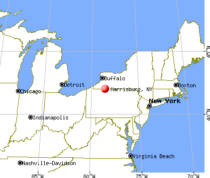
Harrisburg, New York
Submit your own pictures of this town and show them to the world
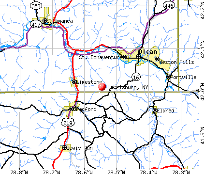
- OSM Map
- General Map
- Google Map
- MSN Map
Population change since 2000: +3.3%
 |
| Males: 236 | |
| Females: 201 |
| Median resident age: | 43.3 years |
| New York median age: | 40.7 years |
Zip codes: 13367.
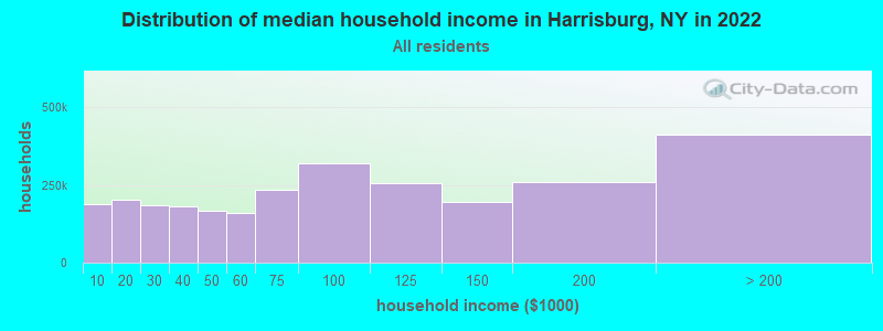
| Harrisburg: | $56,338 |
| NY: | $79,557 |
Estimated per capita income in 2022: $28,812 (it was $13,785 in 2000)
Harrisburg town income, earnings, and wages data
Estimated median house or condo value in 2022: $157,593 (it was $65,500 in 2000)
| Harrisburg: | $157,593 |
| NY: | $400,400 |
Mean prices in 2022: all housing units: $195,982; detached houses: $185,821; townhouses or other attached units: $343,653; in 2-unit structures: $649,528; in 3-to-4-unit structures: $681,838; in 5-or-more-unit structures: $414,780; mobile homes: $75,743
Detailed information about poverty and poor residents in Harrisburg, NY
Compare current foreclosures near Harrisburg, NY:
| Photo | Address | Area | Beds / Baths | Price | Details |
|---|---|---|---|---|---|

|
#1
Andrews Rd
Black River, NY 13612
|
1,848 sq. feet
|
2 baths 2 beds |
$100,000
|
show details |

|
#2
State Pl
Watertown, NY 13601
|
1,608 sq. feet
|
1 baths 4 beds |
$102,500
|
show details |

|
#3
Church St
Castorland, NY 13620
|
2,030 sq. feet
|
3 baths 4 beds |
show details | |

|
#4
Tilden St
Watertown, NY 13601
|
1,416 sq. feet
|
1 baths 3 beds |
show details | |

|
#5
Shepard St
Watertown, NY 13601
|
1,240 sq. feet
|
1 baths 1 beds |
show details | |

|
#6
Burchard St
Watertown, NY 13601
|
1,668 sq. feet
|
2 baths 3 beds |
show details | |

|
#7
Gardner Rd
Rodman, NY 13682
|
1,344 sq. feet
|
2 baths 3 beds |
show details | |

|
#8
Staie Rd
Carthage, NY 13619
|
1,152 sq. feet
|
1 baths 3 beds |
show details | |

|
#9
Hunt St
Watertown, NY 13601
|
1,000 sq. feet
|
1 baths 3 beds |
show details | |

|
#10
Winslow St
Watertown, NY 13601
|
1,958 sq. feet
|
2 baths 4 beds |
show details |
| Photo | Address | Area | Beds / Baths | Price | Details |
|---|---|---|---|---|---|

|
#11
State Route 283
Watertown, NY 13601
|
2,542 sq. feet
|
2 baths 4 beds |
show details | |

|
#12
Bishop St
Watertown, NY 13601
|
2,284 sq. feet
|
2 baths 4 beds |
show details | |

|
#13
Ambrose Dr
Black River, NY 13612
|
1,788 sq. feet
|
2 baths 3 beds |
show details | |

|
#14
N Hamilton St
Watertown, NY 13601
|
1,572 sq. feet
|
1 baths 3 beds |
show details | |

|
#15
Moore Ave
Watertown, NY 13601
|
1,944 sq. feet
|
1 baths 3 beds |
show details | |

|
#16
Broadway Ave W
Watertown, NY 13601
|
3,021 sq. feet
|
3 baths 7 beds |
show details | |

|
#17
State Route 410
Lowville, NY 13367
|
1,839 sq. feet
|
1 baths 3 beds |
show details | |

|
#18
1st St
Carthage, NY 13619
|
1,020 sq. feet
|
1 baths 2 beds |
show details | |

|
#19
Gill St
Watertown, NY 13601
|
1,164 sq. feet
|
1 baths 2 beds |
show details | |

|
#20
Eddy Rd
Carthage, NY 13619
|
1,140 sq. feet
|
1 baths 2 beds |
show details |
| Photo | Address | Area | Beds / Baths | Price | Details |
|---|---|---|---|---|---|

|
#21
Summit Ave
Lowville, NY 13367
|
2,039 sq. feet
|
2 baths 3 beds |
show details | |

|
#22
Dayan St # 2
Lowville, NY 13367
|
2,666 sq. feet
|
3 baths 5 beds |
show details | |

|
#23
Church St
Lowville, NY 13367
|
1,764 sq. feet
|
1 baths 3 beds |
show details | |

|
#24
State Route 126
Castorland, NY 13620
|
1,356 sq. feet
|
1 baths 3 beds |
show details | |

|
#25
County Route 63
Watertown, NY 13601
|
1,614 sq. feet
|
1 baths 3 beds |
show details | |

|
#26
County Route 155
Watertown, NY 13601
|
1,196 sq. feet
|
2 baths 3 beds |
show details | |

|
#27
West St
Carthage, NY 13619
|
2,341 sq. feet
|
3 baths 4 beds |
show details | |

|
#28
Cemetery Rd
Felts Mills, NY 13638
|
720 sq. feet
|
- baths 2 beds |
show details | |

|
#29
Boyd Rd
Carthage, NY 13619
|
560 sq. feet
|
- baths 3 beds |
show details | |

|
#30
High St
Watertown, NY 13601
|
- sq. feet
|
- baths - beds |
show details |
| Photo | Address | Area | Beds / Baths | Price | Details |
|---|---|---|---|---|---|

|
#31
Sunset Rdg
Watertown, NY 13601
|
- sq. feet
|
- baths - beds |
show details | |

|
#32
State Route 283 Lot 19
Black River, NY 13612
|
- sq. feet
|
- baths - beds |
show details | |

|
#33
Chippewa St
Watertown, NY 13603
|
- sq. feet
|
- baths - beds |
show details | |

|
#34
State St Apt 411
Watertown, NY 13601
|
- sq. feet
|
- baths - beds |
show details | |

|
#35
Keyes Ave
Watertown, NY 13601
|
- sq. feet
|
- baths - beds |
show details | |

|
#36
Lafave Rd
Watertown, NY 13601
|
- sq. feet
|
- baths - beds |
show details | |

|
#37
State Route 12
Lowville, NY 13367
|
- sq. feet
|
- baths - beds |
show details | |

|
#38
Boyd St
Watertown, NY 13601
|
- sq. feet
|
- baths - beds |
show details | |

|
#39
Alexandria Street Rd
Carthage, NY 13619
|
- sq. feet
|
- baths - beds |
show details | |

|
#40
S State St
Lowville, NY 13367
|
- sq. feet
|
- baths - beds |
show details |
| Photo | Address | Area | Beds / Baths | Price | Details |
|---|---|---|---|---|---|

|
#41
River Road, Lot 17
Lowville, NY 13367
|
- sq. feet
|
- baths - beds |
show details | |

|
#42
Madison St Apt 109
Carthage, NY 13619
|
- sq. feet
|
- baths - beds |
show details | |

|
#43
N James St
Carthage, NY 13619
|
- sq. feet
|
- baths - beds |
show details | |

|
#44
W End Ave
Carthage, NY 13619
|
- sq. feet
|
- baths - beds |
show details | |

|
#45
Emjay Way
Carthage, NY 13619
|
- sq. feet
|
- baths - beds |
show details | |

|
#46
State Route 3
Carthage, NY 13619
|
- sq. feet
|
- baths - beds |
show details | |

|
#47
Meadow Wood Dr # A
Watertown, NY 13603
|
- sq. feet
|
- baths - beds |
show details | |

|
#48
Main St
Glenfield, NY 13343
|
- sq. feet
|
- baths - beds |
show details | |

|
#49
Main St
Glenfield, NY 13343
|
- sq. feet
|
- baths - beds |
show details | |

|
Check over 1 million property listings on Foreclosure.com!
|
browse all offers | |||

- 43098.4%White alone
- 40.9%Hispanic
- 20.5%Asian alone
- 10.2%Two or more races
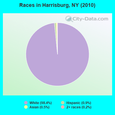
Races in Harrisburg detailed stats: ancestries, foreign born residents, place of birth
 Recent articles from our blog. Our writers, many of them Ph.D. graduates or candidates, create easy-to-read articles on a wide variety of topics.

 | Best Paces to Retire 2024. Gee....Wonder why. (32 replies) |
| Safest Cities from natural disasters (70 replies) |
| Syracuse, NY Highly Rated and Ranked (43 replies) |
| Ithaca to Harrisburg, PA -- I-81 or US-15? (8 replies) |
| Syracuse, NY Population Rankings Using Different Definitions (20 replies) |
| Why Semiconductor Manufacturing in CNY (10 replies) |
Latest news from Harrisburg, NY collected exclusively by city-data.com from local newspapers, TV, and radio stations
Ancestries: Irish (26.5%), German (24.8%), French (20.3%), English (14.9%), Dutch (5.0%), Italian (3.1%).
Current Local Time: EST time zone
Land area: 39.9 square miles.
Population density: 11 people per square mile (very low).
5 residents are foreign born
| This town: | 1.2% |
| New York: | 20.4% |
| Harrisburg town: | 1.1% ($691) |
| New York: | 1.9% ($2,847) |
Nearest city with pop. 50,000+: Clay, NY  (53.6 miles , pop. 58,805).
Nearest city with pop. 200,000+: Rochester, NY (108.2 miles , pop. 219,773).
Nearest city with pop. 1,000,000+: Bronx, NY (224.7 miles , pop. 1,332,650).
Nearest cities:
), ), ), ), ), )Latitude: 43.82 N, Longitude: 75.65 W
Area code commonly used in this area: 315

| Here: | 5.6% |
| New York: | 4.4% |
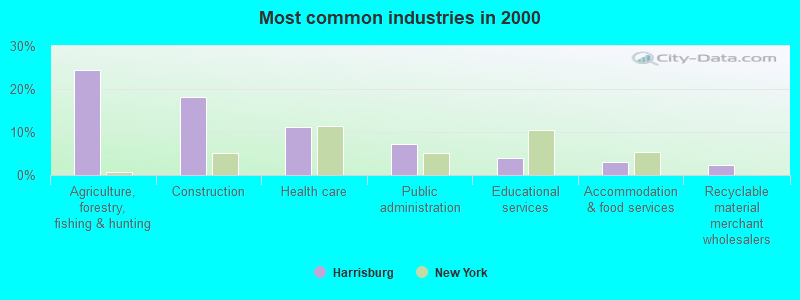
- Agriculture, forestry, fishing & hunting (24.4%)
- Construction (18.0%)
- Health care (11.2%)
- Public administration (7.3%)
- Educational services (3.9%)
- Accommodation & food services (2.9%)
- Recyclable material merchant wholesalers (2.4%)
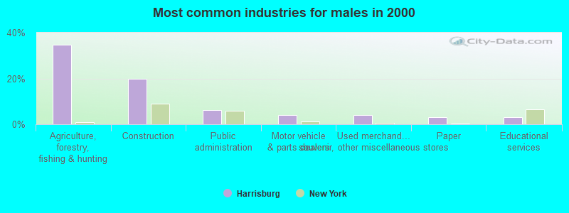
- Agriculture, forestry, fishing & hunting (34.6%)
- Construction (19.7%)
- Public administration (6.3%)
- Motor vehicle & parts dealers (3.9%)
- Used merchandise, gift, novelty, souvenir, other miscellaneous stores (3.9%)
- Paper (3.1%)
- Educational services (3.1%)
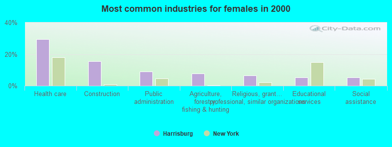
- Health care (29.5%)
- Construction (15.4%)
- Public administration (9.0%)
- Agriculture, forestry, fishing & hunting (7.7%)
- Religious, grantmaking, civic, professional, similar organizations (6.4%)
- Educational services (5.1%)
- Social assistance (5.1%)
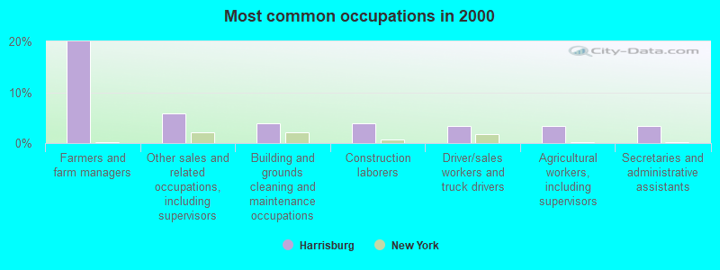
- Farmers and farm managers (20.0%)
- Other sales and related occupations, including supervisors (5.9%)
- Building and grounds cleaning and maintenance occupations (3.9%)
- Construction laborers (3.9%)
- Driver/sales workers and truck drivers (3.4%)
- Agricultural workers, including supervisors (3.4%)
- Secretaries and administrative assistants (3.4%)
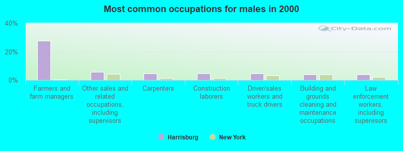
- Farmers and farm managers (27.6%)
- Other sales and related occupations, including supervisors (5.5%)
- Carpenters (4.7%)
- Construction laborers (4.7%)
- Driver/sales workers and truck drivers (4.7%)
- Building and grounds cleaning and maintenance occupations (3.9%)
- Law enforcement workers, including supervisors (3.9%)

- Secretaries and administrative assistants (9.0%)
- Farmers and farm managers (7.7%)
- Supervisors and other personal care and service workers, except child care workers (7.7%)
- Other sales and related occupations, including supervisors (6.4%)
- Food and beverage serving workers, except waiters and waitresses (5.1%)
- Cooks and food preparation workers (5.1%)
- Health technologists and technicians (5.1%)
Average climate in Harrisburg, New York
Based on data reported by over 4,000 weather stations


Earthquake activity:
Harrisburg-area historical earthquake activity is significantly above New York state average. It is 69% smaller than the overall U.S. average.On 10/7/1983 at 10:18:46, a magnitude 5.3 (5.1 MB, 5.3 LG, 5.1 ML, Class: Moderate, Intensity: VI - VII) earthquake occurred 65.9 miles away from Harrisburg center
On 4/20/2002 at 10:50:47, a magnitude 5.3 (5.3 ML, Depth: 3.0 mi) earthquake occurred 108.2 miles away from Harrisburg center
On 4/20/2002 at 10:50:47, a magnitude 5.2 (5.2 MB, 4.2 MS, 5.2 MW, 5.0 MW) earthquake occurred 106.5 miles away from the city center
On 9/25/1998 at 19:52:52, a magnitude 5.2 (4.8 MB, 4.3 MS, 5.2 LG, 4.5 MW, Depth: 3.1 mi) earthquake occurred 290.0 miles away from the city center
On 1/19/1982 at 00:14:42, a magnitude 4.7 (4.5 MB, 4.7 MD, 4.5 LG, Class: Light, Intensity: IV - V) earthquake occurred 203.9 miles away from Harrisburg center
On 6/17/1991 at 08:53:16, a magnitude 4.1 (4.0 MB, 4.0 LG, Depth: 3.1 mi) earthquake occurred 95.6 miles away from Harrisburg center
Magnitude types: regional Lg-wave magnitude (LG), body-wave magnitude (MB), duration magnitude (MD), local magnitude (ML), surface-wave magnitude (MS), moment magnitude (MW)
Natural disasters:
The number of natural disasters in Lewis County (21) is greater than the US average (15).Major Disasters (Presidential) Declared: 11
Emergencies Declared: 9
Causes of natural disasters: Floods: 7, Storms: 7, Winter Storms: 4, Snowstorms: 3, Hurricanes: 2, Snows: 2, Winds: 2, Blizzard: 1, Power Outage: 1, Tornado: 1, Other: 2 (Note: some incidents may be assigned to more than one category).
Hospitals and medical centers near Harrisburg:
- LEWIS COUNTY PUB HEALTH CHHA (Home Health Center, about 8 miles away; LOWVILLE, NY)
- LEWIS COUNTY GENERAL HOSPITAL Acute Care Hospitals (about 8 miles away; LOWVILLE, NY)
- LEWIS COUNTY HOSPICE (Hospital, about 8 miles away; LOWVILLE, NY)
- CARTHAGE AREA HOSPITAL, INC Acute Care Hospitals (about 12 miles away; CARTHAGE, NY)
- THE COUNTRY MANOR NURSING AND REHAB CTR (Nursing Home, about 13 miles away; CARTHAGE, NY)
- RENAL CARE OF NORTHERN NEW YORK, LLC (Dialysis Facility, about 16 miles away; WATERTOWN, NY)
Colleges/universities with over 2000 students nearest to Harrisburg:
- Jefferson Community College (about 19 miles; Watertown, NY; Full-time enrollment: 2,886)
- SUNY College at Oswego (about 52 miles; Oswego, NY; FT enrollment: 7,550)
- Utica College (about 54 miles; Utica, NY; FT enrollment: 2,952)
- Mohawk Valley Community College (about 56 miles; Utica, NY; FT enrollment: 5,693)
- Le Moyne College (about 58 miles; Syracuse, NY; FT enrollment: 3,041)
- St Lawrence University (about 59 miles; Canton, NY; FT enrollment: 2,501)
- Syracuse University (about 60 miles; Syracuse, NY; FT enrollment: 20,717)
Points of interest:
Notable locations in Harrisburg: Windy Acres (A), Northern Quest Farm (B), Harrisburg Town Hall (C). Display/hide their locations on the map
Cemeteries: Battle Cemetery (1), Gallup Cemetery (2). Display/hide their locations on the map
Streams, rivers, and creeks: Cobb Creek (A), Silver Brook (B), Mud Creek (C). Display/hide their locations on the map
| This town: | 2.7 people |
| New York: | 2.6 people |
| This town: | 73.8% |
| Whole state: | 63.5% |
| This town: | 6.2% |
| Whole state: | 6.8% |
No gay or lesbian households reported
| This town: | 13.6% |
| Whole state: | 14.6% |
| This town: | 4.4% |
| Whole state: | 7.4% |
For population 15 years and over in Harrisburg:
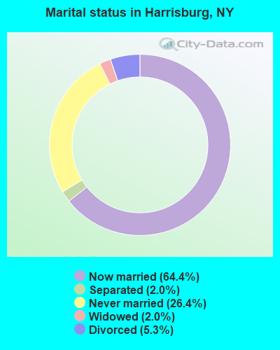
- Never married: 26.4%
- Now married: 64.4%
- Separated: 2.0%
- Widowed: 2.0%
- Divorced: 5.3%
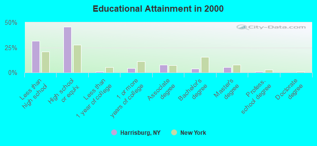
For population 25 years and over in Harrisburg:
- High school or higher: 68.5%
- Bachelor's degree or higher: 10.0%
- Graduate or professional degree: 6.0%
- Unemployed: 6.8%
- Mean travel time to work (commute): 23.7 minutes
| Here: | 10.7 |
| New York average: | 14.2 |
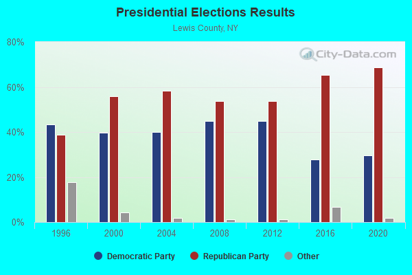
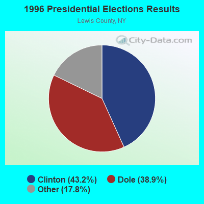
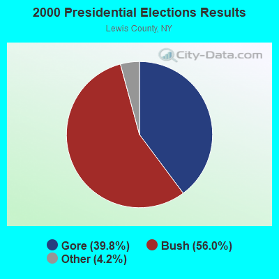
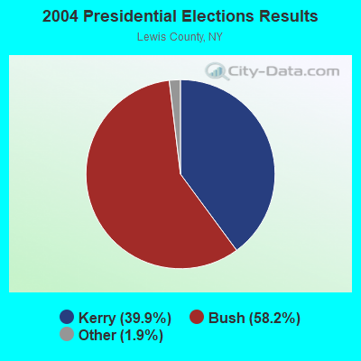
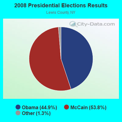
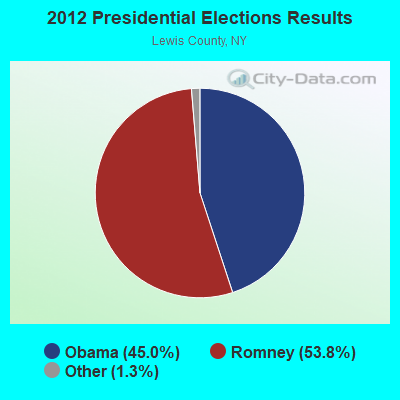
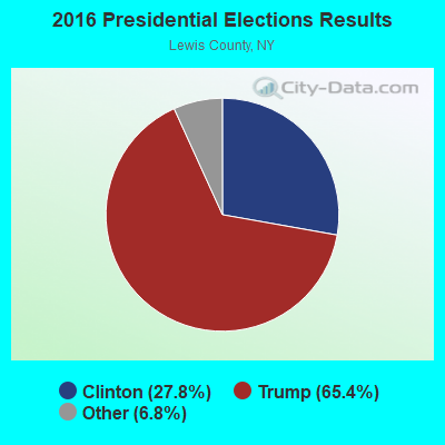
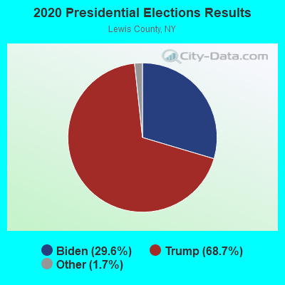
Graphs represent county-level data. Detailed 2008 Election Results
Religion statistics for Harrisburg, NY (based on Lewis County data)
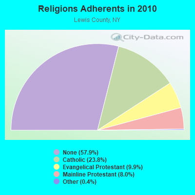
| Religion | Adherents | Congregations |
|---|---|---|
| Catholic | 6,443 | 17 |
| Evangelical Protestant | 2,693 | 21 |
| Mainline Protestant | 2,155 | 25 |
| Other | 115 | 1 |
| None | 15,681 | - |
Food Environment Statistics:
| Here: | 3.41 / 10,000 pop. |
| New York: | 4.13 / 10,000 pop. |
| Lewis County: | 4.92 / 10,000 pop. |
| State: | 1.68 / 10,000 pop. |
| Lewis County: | 10.61 / 10,000 pop. |
| New York: | 8.82 / 10,000 pop. |
| Lewis County: | 9.6% |
| New York: | 8.2% |
| Lewis County: | 27.4% |
| State: | 23.8% |
| This county: | 13.4% |
| New York: | 15.6% |
Strongest AM radio stations in Harrisburg:
- WNER (1410 AM; 5 kW; WATERTOWN, NY)
- WGY (810 AM; 50 kW; SCHENECTADY, NY; Owner: CLEAR CHANNEL BROADCASTING LICENSES, INC.)
- WTNY (790 AM; 1 kW; WATERTOWN, NY; Owner: REGENT LICENSEE OF WATERTOWN, INC.)
- WICY (1490 AM; 50 kW; MALONE, NY; Owner: CARTIER COMMUNICATIONS INC.)
- WHAM (1180 AM; 50 kW; ROCHESTER, NY; Owner: CITICASTERS LICENSES, L.P.)
- WSCP (1070 AM; daytime; 2 kW; SANDY CREEK-PULASKI, NY; Owner: GALAXY COMMUNICATIONS, L.P.)
- WATN (1240 AM; 1 kW; WATERTOWN, NY; Owner: CLANCY-MANCE COMMUNICATIONS, INC)
- WCHP (760 AM; 35 kW; CHAMPLAIN, NY; Owner: CHAMPLAIN RADIO, INC.)
- WPTR (1540 AM; 50 kW; ALBANY, NY; Owner: KIMTRON, INC.)
- WHEN (620 AM; 5 kW; SYRACUSE, NY; Owner: CLEAR CHANNEL BROADCASTING LICENSES, INC.)
- WNNZ (640 AM; 50 kW; WESTFIELD, MA; Owner: CLEAR CHANNEL BROADCASTING LICENSES, INC.)
- WSYR (570 AM; 5 kW; SYRACUSE, NY; Owner: CLEAR CHANNEL BROADCASTING LICENSES, INC.)
- WADR (1480 AM; 5 kW; REMSEN, NY; Owner: CLEAR CHANNEL BROADCASTING LICENSES, INC.)
Strongest FM radio stations in Harrisburg:
- WJNY (90.9 FM; WATERTOWN, NY; Owner: PUBLIC B/CNG COUNCIL CENTRAL NY, INC)
- WBDI (106.7 FM; COPENHAGEN, NY; Owner: FORCE COMMUNICATIONS, INC)
- WLLG (99.3 FM; LOWVILLE, NY; Owner: THE FLACK BROADCASTING GROUP L.L.C.)
- WFRY-FM (97.5 FM; WATERTOWN, NY; Owner: REGENT LICENSEE OF WATERTOWN, INC.)
- WTOJ (103.1 FM; CARTHAGE, NY; Owner: CLANCY-MANCE COMMUNICATIONS, INC.)
- WWJS (90.1 FM; WATERTOWN, NY; Owner: LIBERTY COMMUNICATIONS FAMILY B/G)
- WSLJ (88.9 FM; WATERTOWN, NY; Owner: THE ST. LAWRENCE UNIVERSITY)
- WRVJ (91.7 FM; WATERTOWN, NY; Owner: STATE UNIVERSITY OF NEW YORK)
- WSCP-FM (101.7 FM; PULASKI, NY; Owner: GALAXY COMMUNICATIONS, L.P.)
- WUCL (93.5 FM; REMSEN, NY; Owner: CLEAR CHANNEL BROADCASTING LICENSES, INC.)
- WOTT (100.7 FM; HENDERSON, NY; Owner: JEFFERSON BROADCASTING, INC.)
- WCIZ-FM (93.3 FM; WATERTOWN, NY; Owner: REGENT LICENSEE OF WATERTOWN, INC.)
- W240AN (95.9 FM; COPENHAGEN, ETC., NY; Owner: COPENHAGEN CHRISTIAN RADIO)
- W201CB (88.1 FM; LOWVILLE, NY; Owner: THE ST. LAWRENCE UNIVERSITY)
- W220BO (91.9 FM; LOWVILLE, NY; Owner: BLACK RIVER VALLEY GOSPEL RADIO, INC)
- W261CP (100.1 FM; LOWVILLE, NY; Owner: ENNIS COMMUNICATIONS COMPANY)
TV broadcast stations around Harrisburg:
- WPBS-TV (Channel 16; WATERTOWN, NY; Owner: ST. LAWRENCE VALLEY EDUCATIONAL TV COUNCIL, INC)
- WWTI (Channel 50; WATERTOWN, NY; Owner: CENTRAL NY NEWS, INC.)
- WWNY-TV (Channel 7; CARTHAGE, NY; Owner: UNITED COMMUNICATIONS CORPORATION)
- WSPX-TV (Channel 56; SYRACUSE, NY; Owner: PAXSON SYRACUSE LICENSE, INC.)
- WNYF-CA (Channel 25; WATERTOWN, NY; Owner: UNITED COMMUNICATIONS CORPORATION)
- WBQZ-LP (Channel 34; WATERTOWN, NY; Owner: ANTHONY DiMARCANTONIO)
- WLOT-LP (Channel 66; WATERTOWN, NY; Owner: R. ANTHONY DiMARCANTONIO)
- National Bridge Inventory (NBI) Statistics
- 6Number of bridges
- 30ft / 9.3mTotal length
- $4,515,000Total costs
- 3,683Total average daily traffic
- 665Total average daily truck traffic
- 3,862Total future (year 2034) average daily traffic
FCC Registered Cell Phone Towers:
1- 2424 State Route 177 (Lat: 43.800694 Lon: -75.670583), Type: Tower, Structure height: 59.6 m, Overall height: 60.8 m, Call Sign: KNKN766
Assigned Frequencies: 880.020 MHz, 880.020 MHz, 880.020 MHz, 835.020 MHz, 835.020 MHz, 835.020 MHz, 891.510 MHz, 891.510 MHz, 891.510 MHz, 846.510 MHz, 846.510 MHz, 846.510 MHzGrant Date: 09/01/2020, Expiration Date: 10/01/2030Registrant: Verizon Wireless, 5055 North Point Pkwy, Np2ne Network Engineering, Alpharetta, GA 30022, Phone: (770) 797-1070, Fax: (770) 797-1036, Email:
FCC Registered Antenna Towers:
3- Sean O'Malley, Ny S Rt 12 (Lat: 43.846389 Lon: -75.605833), Type: 60.6, Overall height: 59.4 m, Registrant: Faa/Fcc Compliance Specialist, Bosto-n, Phone: (617) 585-7600
- Sean O'Malley, Ny S Rt 12 (Lat: 43.846389 Lon: -75.605833), Type: 60.6, Overall height: 59.4 m, Registrant: Faa/Fcc Compliance Specialist, Bosto-n, Phone: (617) 585-7600
- Sean O'Malley, Ny S Rt 12 (Lat: 43.846389 Lon: -75.605833), Type: 60.6, Overall height: 59.4 m, Registrant: American Towers, Inc., Bosto-n, Phone: (617) 585-7600
FCC Registered Broadcast Land Mobile Towers:
1- Nichols Run Oil Field (Lat: 42.022000 Lon: -78.562528), Call Sign: KED905,
Assigned Frequencies: 42.1400 MHz, 154.695 MHz, 155.475 MHz, 155.505 MHz, 155.565 MHz, Grant Date: 11/27/2021, Expiration Date: 02/24/2032, Registrant: New York State Police, 1220 Washington Ave, Bldg 22, Albany, NY 12226-2252, Phone: (518) 457-9466, Fax: (518) 457-5676, Email:
- 48.4%Fuel oil, kerosene, etc.
- 33.6%Wood
- 14.8%Bottled, tank, or LP gas
- 3.3%Electricity
- 36.8%Wood
- 31.6%Fuel oil, kerosene, etc.
- 21.1%Bottled, tank, or LP gas
- 10.5%Electricity
Harrisburg compared to New York state average:
- Median house value significantly below state average.
- Unemployed percentage below state average.
- Black race population percentage significantly below state average.
- Hispanic race population percentage significantly below state average.
- Foreign-born population percentage significantly below state average.
- Renting percentage significantly below state average.
- Length of stay since moving in significantly above state average.
- Number of rooms per house significantly below state average.
- House age significantly below state average.
- Number of college students significantly below state average.
- Percentage of population with a bachelor's degree or higher significantly below state average.