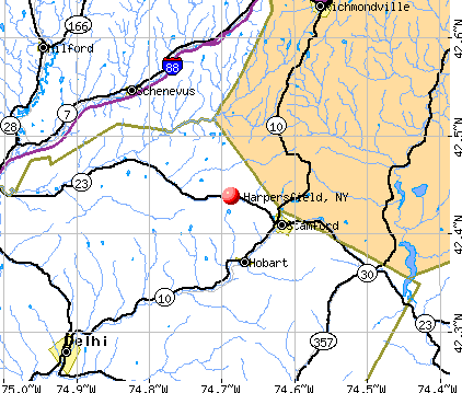
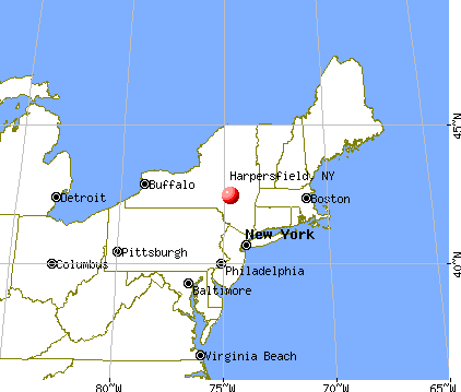
Harpersfield, New York
Submit your own pictures of this town and show them to the world
- OSM Map
- General Map
- Google Map
- MSN Map
Population change since 2000: -1.6%
 |
| Males: 774 | |
| Females: 803 |
| Median resident age: | 48.8 years |
| New York median age: | 40.7 years |
Zip codes: 12167.
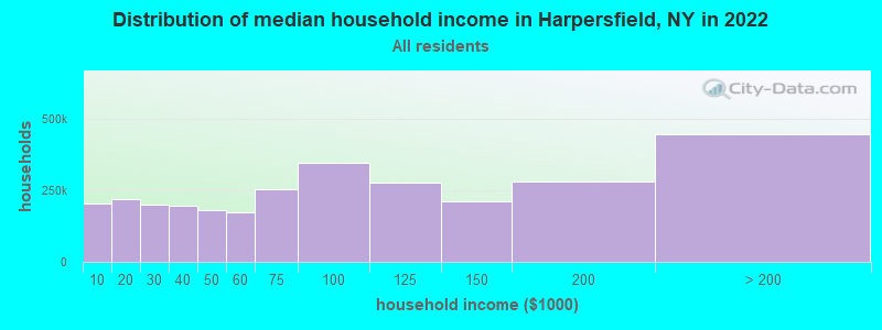
| Harpersfield: | $58,559 |
| NY: | $79,557 |
Estimated per capita income in 2022: $36,415 (it was $18,863 in 2000)
Harpersfield town income, earnings, and wages data
Estimated median house or condo value in 2022: $173,466 (it was $77,600 in 2000)
| Harpersfield: | $173,466 |
| NY: | $400,400 |
Mean prices in 2022: all housing units: $272,591; detached houses: $254,359; townhouses or other attached units: $225,571; in 2-unit structures: $277,007; in 3-to-4-unit structures: $721,615; in 5-or-more-unit structures: $247,836; mobile homes: $89,185
Detailed information about poverty and poor residents in Harpersfield, NY


- 1,47593.5%White alone
- 563.6%Hispanic
- 191.2%Black alone
- 151.0%Two or more races
- 80.5%Asian alone
- 40.3%American Indian alone
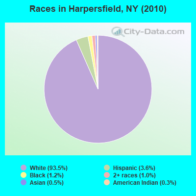
Races in Harpersfield detailed stats: ancestries, foreign born residents, place of birth
According to our research of New York and other state lists, there was 1 registered sex offender living in Harpersfield, New York as of May 18, 2024.
The ratio of all residents to sex offenders in Harpersfield is 1,577 to 1.
The ratio of registered sex offenders to all residents in this city is lower than the state average.
 Recent articles from our blog. Our writers, many of them Ph.D. graduates or candidates, create easy-to-read articles on a wide variety of topics.

 | South Kortright, Stamford - Anyone know what they are like? (4 replies) |
| Wind Turbine Proposal Submitted to Stamford, Roxbury, NY - Invenergy LLC (71 replies) |
Latest news from Harpersfield, NY collected exclusively by city-data.com from local newspapers, TV, and radio stations
Ancestries: German (17.8%), Italian (16.6%), Irish (15.3%), English (10.9%), Polish (5.4%), United States (5.1%).
Current Local Time: EST time zone
Land area: 42.1 square miles.
Population density: 37 people per square mile (very low).
62 residents are foreign born (3.4% Europe).
| This town: | 3.9% |
| New York: | 20.4% |
| Harpersfield town: | 3.0% ($2,321) |
| New York: | 1.9% ($2,847) |
Nearest city with pop. 50,000+: Schenectady, NY  (45.6 miles , pop. 61,821).
Nearest city with pop. 200,000+: Bronx, NY (117.3 miles , pop. 1,332,650).
Nearest cities:
), ), ), Latitude: 42.44 N, Longitude: 74.67 W
Area code commonly used in this area: 607

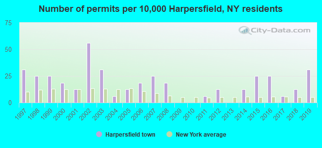
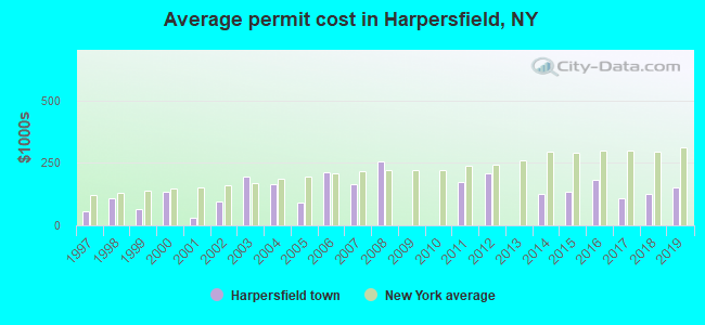
Single-family new house construction building permits:
- 2019: 5 buildings, average cost: $152,000
- 2018: 2 buildings, average cost: $126,300
- 2017: 1 building, cost: $110,000
- 2016: 4 buildings, average cost: $181,300
- 2015: 4 buildings, average cost: $133,700
- 2014: 2 buildings, average cost: $125,000
- 2012: 2 buildings, average cost: $210,000
- 2011: 1 building, cost: $175,000
- 2008: 3 buildings, average cost: $256,700
- 2007: 4 buildings, average cost: $164,400
- 2006: 3 buildings, average cost: $213,300
- 2005: 2 buildings, average cost: $90,000
- 2004: 1 building, cost: $165,000
- 2003: 5 buildings, average cost: $193,400
- 2002: 9 buildings, average cost: $94,700
- 2001: 2 buildings, average cost: $28,800
- 2000: 3 buildings, average cost: $133,800
- 1999: 4 buildings, average cost: $65,000
- 1998: 4 buildings, average cost: $110,000
- 1997: 5 buildings, average cost: $55,600
| Here: | 4.7% |
| New York: | 4.4% |
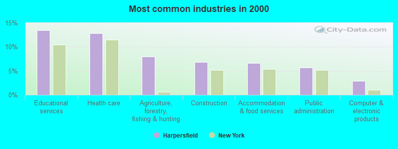
- Educational services (13.4%)
- Health care (12.8%)
- Agriculture, forestry, fishing & hunting (7.9%)
- Construction (6.8%)
- Accommodation & food services (6.6%)
- Public administration (5.7%)
- Computer & electronic products (2.9%)
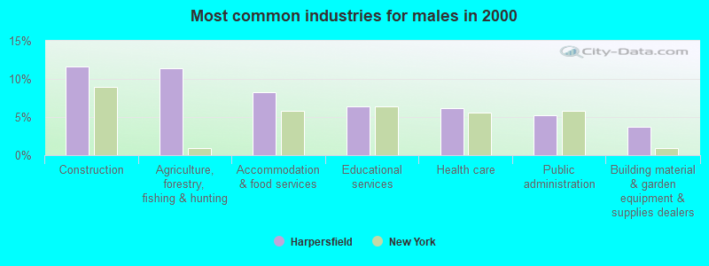
- Construction (11.7%)
- Agriculture, forestry, fishing & hunting (11.3%)
- Accommodation & food services (8.3%)
- Educational services (6.4%)
- Health care (6.1%)
- Public administration (5.2%)
- Building material & garden equipment & supplies dealers (3.7%)
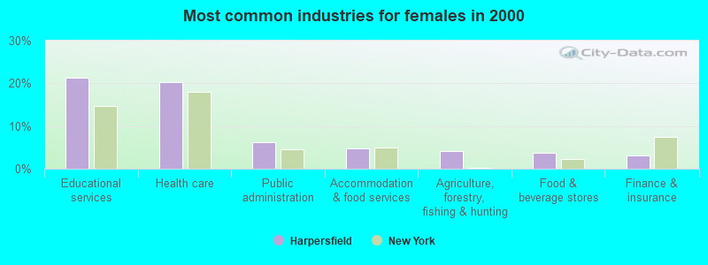
- Educational services (21.2%)
- Health care (20.2%)
- Public administration (6.2%)
- Accommodation & food services (4.8%)
- Agriculture, forestry, fishing & hunting (4.1%)
- Food & beverage stores (3.8%)
- Finance & insurance (3.1%)
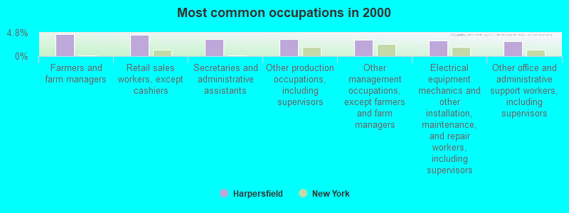
- Farmers and farm managers (4.5%)
- Retail sales workers, except cashiers (4.4%)
- Secretaries and administrative assistants (3.6%)
- Other production occupations, including supervisors (3.6%)
- Other management occupations, except farmers and farm managers (3.4%)
- Electrical equipment mechanics and other installation, maintenance, and repair workers, including supervisors (3.2%)
- Other office and administrative support workers, including supervisors (3.1%)
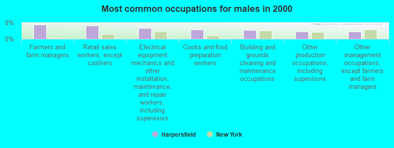
- Farmers and farm managers (7.1%)
- Retail sales workers, except cashiers (6.4%)
- Electrical equipment mechanics and other installation, maintenance, and repair workers, including supervisors (5.2%)
- Cooks and food preparation workers (4.6%)
- Building and grounds cleaning and maintenance occupations (4.3%)
- Other production occupations, including supervisors (3.7%)
- Other management occupations, except farmers and farm managers (3.7%)
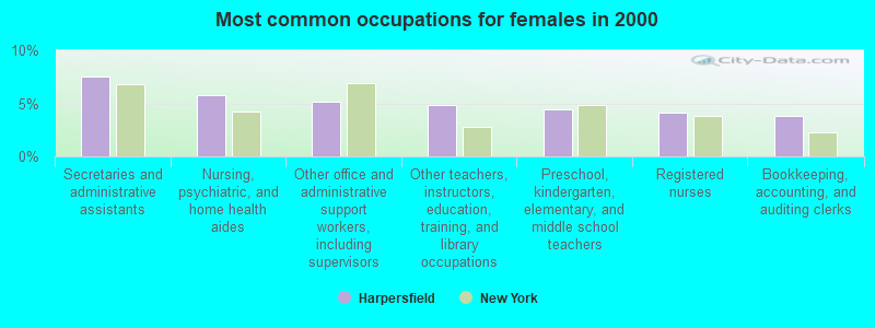
- Secretaries and administrative assistants (7.5%)
- Nursing, psychiatric, and home health aides (5.8%)
- Other office and administrative support workers, including supervisors (5.1%)
- Other teachers, instructors, education, training, and library occupations (4.8%)
- Preschool, kindergarten, elementary, and middle school teachers (4.5%)
- Registered nurses (4.1%)
- Bookkeeping, accounting, and auditing clerks (3.8%)
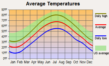
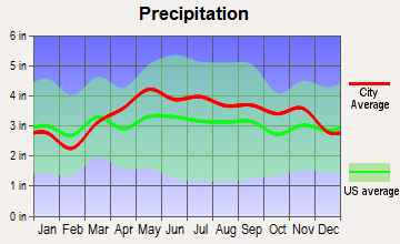
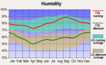
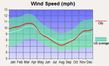
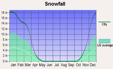
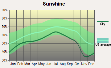
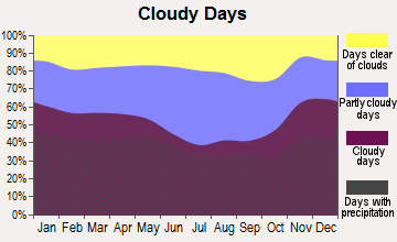
Average climate in Harpersfield, New York
Based on data reported by over 4,000 weather stations
(lower is better)
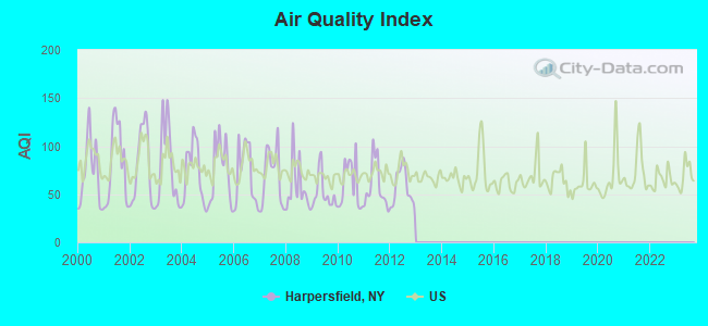
Air Quality Index (AQI) level in 2012 was 56.9. This is better than average.
| City: | 56.9 |
| U.S.: | 72.6 |
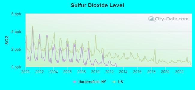
Sulfur Dioxide (SO2) [ppb] level in 2012 was 0.314. This is significantly better than average. Closest monitor was 22.1 miles away from the city center.
| City: | 0.314 |
| U.S.: | 1.515 |
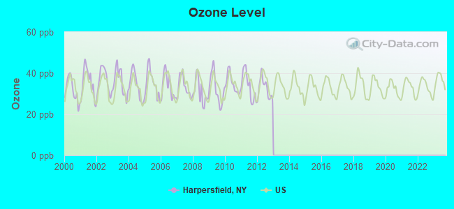
Ozone [ppb] level in 2012 was 32.5. This is about average. Closest monitor was 22.1 miles away from the city center.
| City: | 32.5 |
| U.S.: | 33.3 |
Tornado activity:
Harpersfield-area historical tornado activity is near New York state average. It is 59% smaller than the overall U.S. average.
On 7/10/1989, a category F4 (max. wind speeds 207-260 mph) tornado 28.2 miles away from the Harpersfield town center injured 20 people and caused between $5,000,000 and $50,000,000 in damages.
On 5/31/1998, a category F3 (max. wind speeds 158-206 mph) tornado 16.6 miles away from the town center injured 3 people and caused $800,000 in damages.
Earthquake activity:
Harpersfield-area historical earthquake activity is significantly above New York state average. It is 67% smaller than the overall U.S. average.On 10/7/1983 at 10:18:46, a magnitude 5.3 (5.1 MB, 5.3 LG, 5.1 ML, Class: Moderate, Intensity: VI - VII) earthquake occurred 106.3 miles away from Harpersfield center
On 4/20/2002 at 10:50:47, a magnitude 5.3 (5.3 ML, Depth: 3.0 mi) earthquake occurred 151.8 miles away from Harpersfield center
On 4/20/2002 at 10:50:47, a magnitude 5.2 (5.2 MB, 4.2 MS, 5.2 MW, 5.0 MW) earthquake occurred 149.8 miles away from Harpersfield center
On 6/17/1991 at 08:53:16, a magnitude 4.1 (4.0 MB, 4.0 LG, Depth: 3.1 mi, Class: Light, Intensity: IV - V) earthquake occurred 13.5 miles away from Harpersfield center
On 8/23/2011 at 17:51:04, a magnitude 5.8 (5.8 MW, Depth: 3.7 mi) earthquake occurred 357.4 miles away from the city center
On 1/19/1982 at 00:14:42, a magnitude 4.7 (4.5 MB, 4.7 MD, 4.5 LG) earthquake occurred 172.0 miles away from the city center
Magnitude types: regional Lg-wave magnitude (LG), body-wave magnitude (MB), duration magnitude (MD), local magnitude (ML), surface-wave magnitude (MS), moment magnitude (MW)
Natural disasters:
The number of natural disasters in Delaware County (36) is a lot greater than the US average (15).Major Disasters (Presidential) Declared: 24
Emergencies Declared: 10
Causes of natural disasters: Floods: 17, Storms: 15, Hurricanes: 4, Snowstorms: 3, Winter Storms: 3, Blizzards: 2, Tornadoes: 2, Tropical Storms: 2, Heavy Rain: 1, Power Outage: 1, Tropical Depression: 1, Water Shortage: 1, Wind: 1, Other: 3 (Note: some incidents may be assigned to more than one category).
Colleges/universities with over 2000 students nearest to Harpersfield:
- SUNY College of Technology at Delhi (about 18 miles; Delhi, NY; Full-time enrollment: 2,911)
- SUNY College of Agriculture and Technology at Cobleskill (about 18 miles; Cobleskill, NY; FT enrollment: 2,455)
- SUNY Oneonta (about 21 miles; Oneonta, NY; FT enrollment: 6,081)
- Fulton-Montgomery Community College (about 43 miles; Johnstown, NY; FT enrollment: 2,043)
- Herkimer County Community College (about 45 miles; Herkimer, NY; FT enrollment: 2,774)
- Schenectady County Community College (about 46 miles; Schenectady, NY; FT enrollment: 3,676)
- Excelsior College (about 46 miles; Albany, NY; FT enrollment: 4,723)
Points of interest:
Notable locations in Harpersfield: Shaver Hill Farm (A), Stamford Sewage Treatment Plant (B), Stamford Golf Club (C), Robinson Terrace (D), Seventh Heaven Assisted Living Center (E). Display/hide their locations on the map
Churches in Harpersfield include: Stamford Baptist Church (A), Sacred Heart Church (B). Display/hide their locations on the map
Cemeteries: Quaker Hill Cemetery (1), Bennett Cemetery (2), Stevens Cemetery (3), Harpersfield Center Cemetery (4), North Harpersfield Cemetery (5), Titus Hill Cemetery (6). Display/hide their locations on the map
Lakes: Odell Lake (A), Rexmere Lakes (B), Titus Lake (C), Clapper Lake (D). Display/hide their locations on the map
Streams, rivers, and creeks: Basset Brook (A). Display/hide its location on the map
Birthplace of: Ned Buntline - Novelist.
| This town: | 2.4 people |
| New York: | 2.6 people |
| This town: | 68.2% |
| Whole state: | 63.5% |
| This town: | 8.2% |
| Whole state: | 6.8% |
Likely homosexual households (counted as self-reported same-sex unmarried-partner households)
- Lesbian couples: 0.2% of all households
- Gay men: 0.0% of all households
| This town: | 18.3% |
| Whole state: | 14.6% |
| This town: | 7.5% |
| Whole state: | 7.4% |
119 people in nursing homes in 2000
16 people in other noninstitutional group quarters in 2000
For population 15 years and over in Harpersfield:
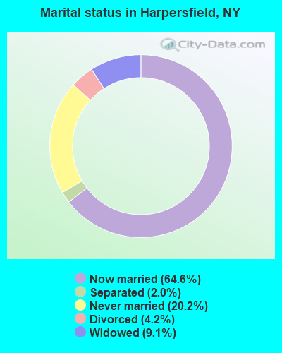
- Never married: 20.2%
- Now married: 64.6%
- Separated: 2.0%
- Widowed: 9.1%
- Divorced: 4.2%
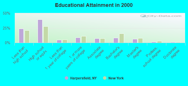
For population 25 years and over in Harpersfield:
- High school or higher: 76.4%
- Bachelor's degree or higher: 16.8%
- Graduate or professional degree: 8.8%
- Unemployed: 12.5%
- Mean travel time to work (commute): 28.3 minutes
| Here: | 12.6 |
| New York average: | 14.2 |
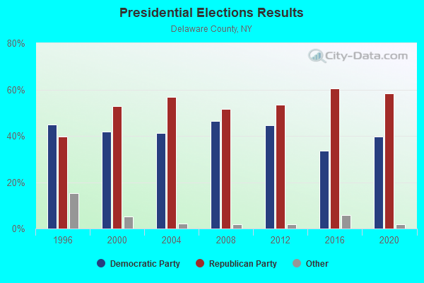
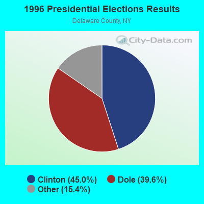
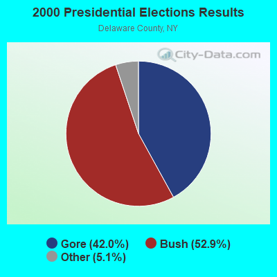
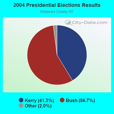
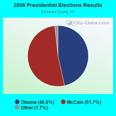
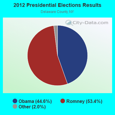
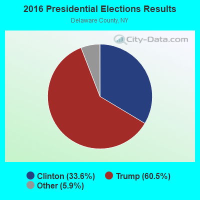
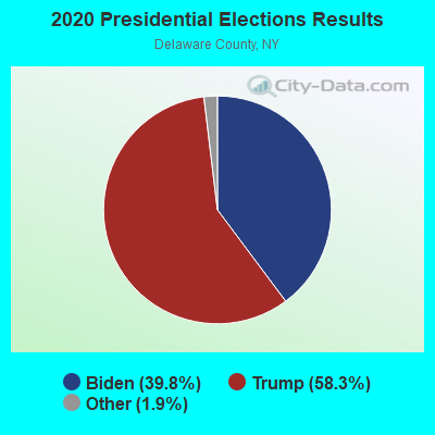
Graphs represent county-level data. Detailed 2008 Election Results
Religion statistics for Harpersfield, NY (based on Delaware County data)
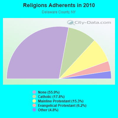
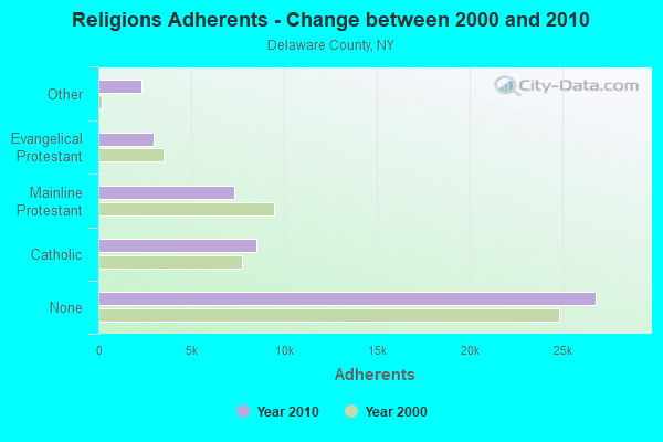
| Religion | Adherents | Congregations |
|---|---|---|
| Catholic | 8,538 | 9 |
| Mainline Protestant | 7,325 | 65 |
| Evangelical Protestant | 2,951 | 30 |
| Other | 2,327 | 10 |
| Orthodox | 12 | 1 |
| None | 26,827 | - |
Food Environment Statistics:
| Delaware County: | 3.02 / 10,000 pop. |
| New York: | 4.13 / 10,000 pop. |
| This county: | 0.43 / 10,000 pop. |
| State: | 0.92 / 10,000 pop. |
| Delaware County: | 7.56 / 10,000 pop. |
| State: | 1.68 / 10,000 pop. |
| Here: | 12.09 / 10,000 pop. |
| New York: | 8.82 / 10,000 pop. |
| Delaware County: | 8.2% |
| New York: | 8.2% |
| Delaware County: | 25.3% |
| New York: | 23.8% |
| Delaware County: | 17.0% |
| State: | 15.6% |
Strongest AM radio stations in Harpersfield:
- WGY (810 AM; 50 kW; SCHENECTADY, NY; Owner: CLEAR CHANNEL BROADCASTING LICENSES, INC.)
- WPTR (1540 AM; 50 kW; ALBANY, NY; Owner: KIMTRON, INC.)
- WNNZ (640 AM; 50 kW; WESTFIELD, MA; Owner: CLEAR CHANNEL BROADCASTING LICENSES, INC.)
- WMCA (570 AM; 50 kW; NEW YORK, NY; Owner: SALEM MEDIA OF NEW YORK, LLC)
- WFAN (660 AM; 50 kW; NEW YORK, NY; Owner: INFINITY BROADCASTING OPERATIONS, INC.)
- WABC (770 AM; 50 kW; NEW YORK, NY; Owner: WABC-AM RADIO, INC.)
- WOR (710 AM; 50 kW; NEW YORK, NY; Owner: BUCKLEY BROADCASTING CORPORATION)
- WDLA (1270 AM; 5 kW; WALTON, NY; Owner: BANJO COMMUNICATIONS GROUP, INC.)
- WDOS (730 AM; 1 kW; ONEONTA, NY; Owner: ULTIMATE B/CASTING NETWORK, INC.)
- WTIC (1080 AM; 50 kW; HARTFORD, CT; Owner: INFINITY RADIO OPERATIONS INC.)
- WCBS (880 AM; 50 kW; NEW YORK, NY; Owner: INFINITY BROADCASTING OPERATIONS, INC.)
- WROW (590 AM; 5 kW; ALBANY, NY; Owner: 6 JOHNSON ROAD LICENSES, INC.)
- WINS (1010 AM; 50 kW; NEW YORK, NY; Owner: INFINITY BROADCASTING OPERATIONS, INC.)
Strongest FM radio stations in Harpersfield:
- WGKR (105.3 FM; GRAND GORGE, NY; Owner: SOUND OF LIFE, INC.)
- WDHI (100.3 FM; DELHI, NY; Owner: BANJO COMMUNICATIONS GROUP, INC.)
- WRIP (97.9 FM; WINDHAM, NY; Owner: RIP RADIO, LLC)
- WJIV (101.9 FM; CHERRY VALLEY, NY; Owner: CHRISTIAN BROADCASTING SYSTEM, LTD.)
- WMYY (97.3 FM; SCHOHARIE, NY; Owner: CAPITAL MEDIA CORPORATION)
- WAMK (90.9 FM; KINGSTON, NY; Owner: W A M C)
- WFGB (89.7 FM; KINGSTON, NY; Owner: SOUND OF LIFE, INC.)
- WSQC-FM (91.7 FM; ONEONTA, NY; Owner: WSKG PUBLIC TELECOMM. COUNCIL)
- WSRK (103.9 FM; ONEONTA, NY; Owner: ULTIMATE B/CASTING NETWORK, INC.)
- WAJZ (96.3 FM; VOORHEESVILLE, NY; Owner: 6 JOHNSON ROAD LICENSES, INC.)
- WZMR (104.9 FM; ALTAMONT, NY; Owner: 6 JOHNSON ROAD LICENSES, INC.)
- WYJB (95.5 FM; ALBANY, NY; Owner: 6 JOHNSON ROAD LICENSES, INC.)
- WGNA-FM (107.7 FM; ALBANY, NY; Owner: REGENT LICENSEE OF MANSFIELD, INC.)
- WFKP (99.3 FM; ELLENVILLE, NY; Owner: CLEAR CHANNEL BROADCASTING LICENSES, INC.)
- WMHT-FM (89.1 FM; SCHENECTADY, NY; Owner: WMHT EDUCATIONAL TELECOMMUNICATIONS)
- WRVE (99.5 FM; SCHENECTADY, NY; Owner: CLEAR CHANNEL BROADCASTING LICENSES, INC.)
- WPYX (106.5 FM; ALBANY, NY; Owner: CAPSTAR TX LIMITED PARTNERSHIP)
- WDLA-FM (92.1 FM; WALTON, NY; Owner: BANJO COMMUNICATIONS GROUP, INC.)
- WVCR-FM (88.3 FM; LOUDONVILLE, NY; Owner: SIENA COLLEGE)
- WFLY (92.3 FM; TROY, NY; Owner: 6 JOHNSON ROAD LICENSES, INC.)
- Harpersfield, New York
- Fatal accident count8
- Vehicles involved in fatal accidents10
- Fatal accidents involving drunk persons:4
- Fatalities8
- Persons involved in fatal accidents11
- Pedestrians involved in fatal accidents1
- New York average
- Fatal accident count6224
- Vehicles involved in fatal accidents9132
- Fatal accidents involving drunk persons1378
- Fatalities6724
- Persons involved in fatal accidents15249
- Pedestrians involved in fatal accidents2050
- National Bridge Inventory (NBI) Statistics
- 5Number of bridges
- 23ft / 6.8mTotal length
- $3,917,000Total costs
- 1,732Total average daily traffic
- 122Total average daily truck traffic
- 2,425Total future (year 2036) average daily traffic
FCC Registered Antenna Towers:
1- Todd C Scaccia, 25399 State Highway (Lat: 42.439083 Lon: -74.678722), Type: 36.6, Overall height: 36.6 m, Registrant: Wireless Applications Corporation, Fcc@wacorp.Net, , Belle-vue, Phone: (425) 643-5000
FCC Registered Amateur Radio Licenses:
4- Call Sign: KA2KAI, Licensee ID: L01506015, Grant Date: 05/21/2019, Expiration Date: 07/17/2029, Registrant: Sandra A Arnone, 152 Wind Song Road, Harpersfield, NY 13786
- Call Sign: KQ2A, Licensee ID: L00421417, Grant Date: 09/18/2018, Expiration Date: 09/18/2028, Registrant: Victor J Arnone, 152 Wind Song Road, Harpersfield, NY 13786
- Call Sign: KC2JXY, Licensee ID: L00540161, Grant Date: 07/06/2012, Expiration Date: 07/01/2022, Certifier: Dennis F King, Registrant: Dennis F King, 335 Gaffey Rd, Harpersfield, NY 13786
- Call Sign: KD2ETN, Licensee ID: L01816753, Grant Date: 10/17/2013, Expiration Date: 10/17/2023, Certifier: David Pawlak, Registrant: David Pawlak, 815 Smith Rd, Harpersfield, NY 13786
| Most common first names in Harpersfield, NY among deceased individuals | ||
| Name | Count | Lived (average) |
|---|---|---|
| William | 6 | 80.7 years |
| Edward | 4 | 70.0 years |
| Donald | 3 | 73.7 years |
| John | 3 | 76.7 years |
| Thomas | 3 | 71.0 years |
| Barbara | 2 | 79.5 years |
| Grace | 2 | 87.0 years |
| Anna | 2 | 80.5 years |
| James | 2 | 82.0 years |
| Joseph | 2 | 83.5 years |
| Most common last names in Harpersfield, NY among deceased individuals | ||
| Last name | Count | Lived (average) |
|---|---|---|
| Faoro | 2 | 88.5 years |
| Banks | 2 | 67.0 years |
| Fisher | 2 | 78.5 years |
| Kiel | 2 | 87.0 years |
| Johns | 2 | 83.9 years |
| Jones | 2 | 71.0 years |
| Bruzzo | 2 | 77.5 years |
| Kean | 2 | 75.6 years |
| Champlin | 2 | 78.5 years |
| Hillis | 2 | 70.0 years |
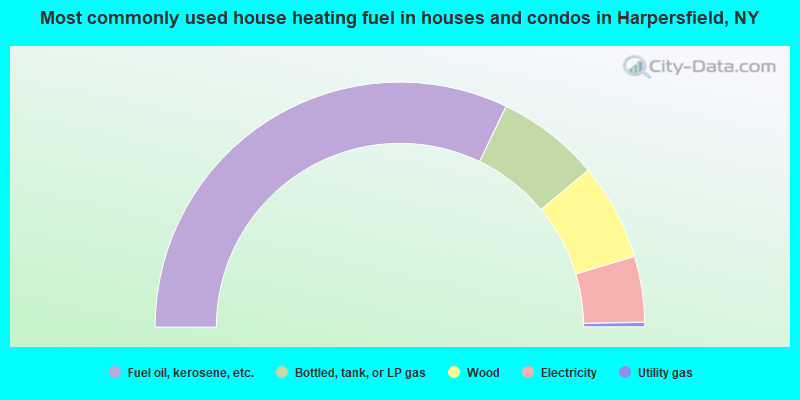
- 64.3%Fuel oil, kerosene, etc.
- 13.6%Bottled, tank, or LP gas
- 12.8%Wood
- 8.7%Electricity
- 0.6%Utility gas
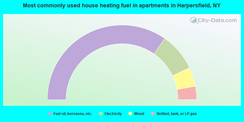
- 69.4%Fuel oil, kerosene, etc.
- 16.5%Electricity
- 8.3%Wood
- 5.8%Bottled, tank, or LP gas
Harpersfield compared to New York state average:
- Median house value significantly below state average.
- Black race population percentage significantly below state average.
- Hispanic race population percentage significantly below state average.
- Median age significantly above state average.
- Foreign-born population percentage significantly below state average.
- Renting percentage below state average.
- Length of stay since moving in significantly above state average.
- Number of rooms per house significantly below state average.
- House age significantly below state average.
- Institutionalized population percentage significantly above state average.
- Number of college students below state average.
- Percentage of population with a bachelor's degree or higher below state average.