Halcott, New York
Submit your own pictures of this town and show them to the world
- OSM Map
- Google Map
- MSN Map
Population change since 2000: +33.7%
| Males: 129 | |
| Females: 129 |
| Median resident age: | 55.7 years |
| New York median age: | 40.7 years |
Zip code: 12430
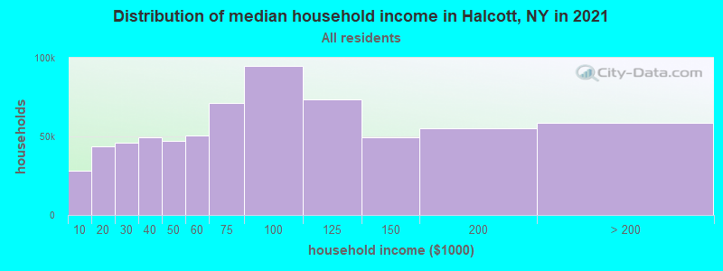
| Halcott: | $58,548 |
| NY: | $79,557 |
Estimated per capita income in 2022: $44,314 (it was $21,627 in 2000)
Estimated median house or condo value in 2022: $276,726 (it was $106,300 in 2000)
| Halcott: | $276,726 |
| NY: | $400,400 |
Mean prices in 2022: all housing units: $264,283; detached houses: $262,676; townhouses or other attached units: $340,037; in 2-unit structures: $437,043; in 3-to-4-unit structures: $263,666; in 5-or-more-unit structures: $906,197; mobile homes: $216,338
Detailed information about poverty and poor residents in Halcott, NY


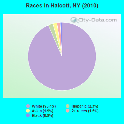
- 24193.4%White alone
- 62.3%Hispanic
- 51.9%Asian alone
- 41.6%Two or more races
- 20.8%Black alone
 Recent articles from our blog. Our writers, many of them Ph.D. graduates or candidates, create easy-to-read articles on a wide variety of topics.
Ancestries: German (24.4%), English (23.8%), Italian (22.8%), Greek (9.3%), Irish (9.3%), Polish (6.7%).
Current Local Time: EST time zone
Land area: 23.0 square miles.
Population density: 11 people per square mile (very low).
21 residents are foreign born (9.3% Europe, 1.6% Asia).
| This town: | 10.9% |
| New York: | 20.4% |
| Halcott town: | 1.3% ($1,354) |
| New York: | 1.9% ($2,847) |
Nearest city with pop. 50,000+: Albany, NY  (47.8 miles , pop. 95,658).
Nearest city with pop. 200,000+: Bronx, NY (98.9 miles , pop. 1,332,650).
Nearest cities:
), ), )Latitude: 42.20 N, Longitude: 74.48 W
Area code commonly used in this area: 845
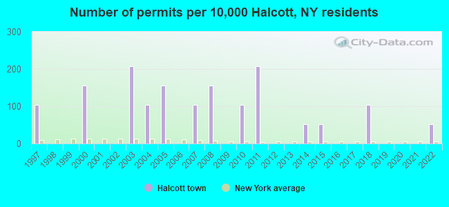
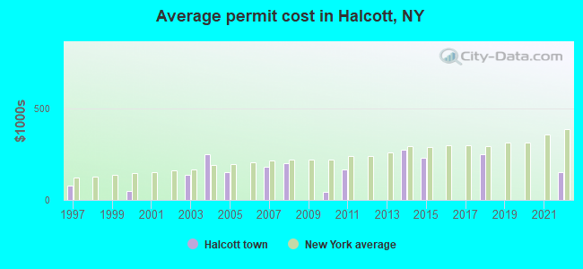
Single-family new house construction building permits:
- 2022: 1 building, cost: $150,000
- 2018: 2 buildings, average cost: $250,000
- 2015: 1 building, cost: $230,000
- 2014: 1 building, cost: $275,000
- 2011: 4 buildings, average cost: $165,000
- 2010: 2 buildings, average cost: $42,500
- 2008: 3 buildings, average cost: $200,000
- 2007: 2 buildings, average cost: $180,300
- 2005: 3 buildings, average cost: $150,000
- 2004: 2 buildings, average cost: $250,000
- 2003: 4 buildings, average cost: $136,300
- 2000: 3 buildings, average cost: $46,700
- 1997: 2 buildings, average cost: $77,500
| Here: | 4.3% |
| New York: | 4.4% |
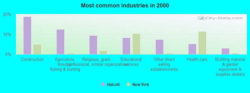
- Construction (18.9%)
- Agriculture, forestry, fishing & hunting (12.6%)
- Religious, grantmaking, civic, professional, similar organizations (9.5%)
- Educational services (8.4%)
- Other direct selling establishments (7.4%)
- Health care (5.3%)
- Building material & garden equipment & supplies dealers (3.2%)
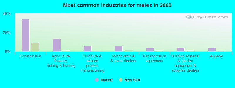
- Construction (34.0%)
- Agriculture, forestry, fishing & hunting (13.2%)
- Furniture & related product manufacturing (5.7%)
- Motor vehicle & parts dealers (5.7%)
- Transportation equipment (3.8%)
- Building material & garden equipment & supplies dealers (3.8%)
- Apparel (3.8%)
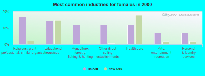
- Religious, grantmaking, civic, professional, similar organizations (16.7%)
- Educational services (14.3%)
- Agriculture, forestry, fishing & hunting (11.9%)
- Other direct selling establishments (11.9%)
- Health care (11.9%)
- Arts, entertainment, recreation (7.1%)
- Personal & laundry services (7.1%)
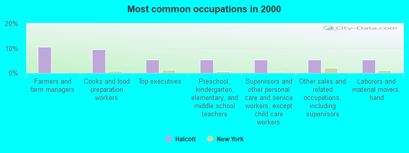
- Farmers and farm managers (10.5%)
- Cooks and food preparation workers (9.5%)
- Top executives (5.3%)
- Preschool, kindergarten, elementary, and middle school teachers (5.3%)
- Supervisors and other personal care and service workers, except child care workers (5.3%)
- Other sales and related occupations, including supervisors (5.3%)
- Laborers and material movers, hand (5.3%)
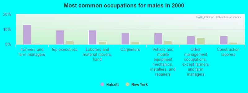
- Farmers and farm managers (13.2%)
- Top executives (9.4%)
- Laborers and material movers, hand (9.4%)
- Carpenters (7.5%)
- Vehicle and mobile equipment mechanics, installers, and repairers (7.5%)
- Other management occupations, except farmers and farm managers (5.7%)
- Construction laborers (5.7%)
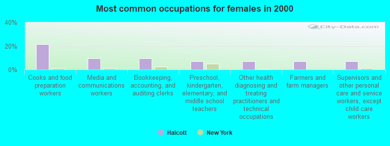
- Cooks and food preparation workers (21.4%)
- Media and communications workers (9.5%)
- Bookkeeping, accounting, and auditing clerks (9.5%)
- Preschool, kindergarten, elementary, and middle school teachers (7.1%)
- Other health diagnosing and treating practitioners and technical occupations (7.1%)
- Farmers and farm managers (7.1%)
- Supervisors and other personal care and service workers, except child care workers (7.1%)
Average climate in Halcott, New York
Based on data reported by over 4,000 weather stations


(lower is better)
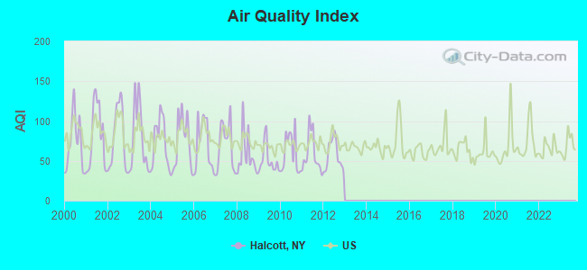
Air Quality Index (AQI) level in 2012 was 56.9. This is better than average.
| City: | 56.9 |
| U.S.: | 72.6 |
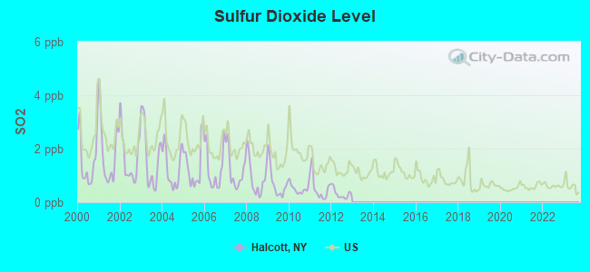
Sulfur Dioxide (SO2) [ppb] level in 2012 was 0.314. This is significantly better than average. Closest monitor was 4.1 miles away from the city center.
| City: | 0.314 |
| U.S.: | 1.515 |
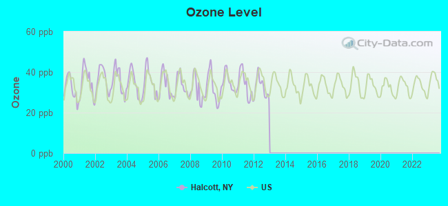
Ozone [ppb] level in 2012 was 32.5. This is about average. Closest monitor was 4.1 miles away from the city center.
| City: | 32.5 |
| U.S.: | 33.3 |
Tornado activity:
Halcott-area historical tornado activity is slightly above New York state average. It is 51% smaller than the overall U.S. average.
On 7/10/1989, a category F4 (max. wind speeds 207-260 mph) tornado 26.2 miles away from the Halcott town center injured 20 people and caused between $5,000,000 and $50,000,000 in damages.
On 5/31/1998, a category F3 (max. wind speeds 158-206 mph) tornado 27.8 miles away from the town center injured 12 people and caused $3 million in damages.
Earthquake activity:
Halcott-area historical earthquake activity is significantly above New York state average. It is 67% smaller than the overall U.S. average.On 10/7/1983 at 10:18:46, a magnitude 5.3 (5.1 MB, 5.3 LG, 5.1 ML, Class: Moderate, Intensity: VI - VII) earthquake occurred 121.3 miles away from Halcott center
On 4/20/2002 at 10:50:47, a magnitude 5.3 (5.3 ML, Depth: 3.0 mi) earthquake occurred 164.6 miles away from Halcott center
On 4/20/2002 at 10:50:47, a magnitude 5.2 (5.2 MB, 4.2 MS, 5.2 MW, 5.0 MW) earthquake occurred 162.6 miles away from the city center
On 8/23/2011 at 17:51:04, a magnitude 5.8 (5.8 MW, Depth: 3.7 mi) earthquake occurred 348.6 miles away from the city center
On 6/17/1991 at 08:53:16, a magnitude 4.1 (4.0 MB, 4.0 LG, Depth: 3.1 mi, Class: Light, Intensity: IV - V) earthquake occurred 31.2 miles away from Halcott center
On 1/19/1982 at 00:14:42, a magnitude 4.7 (4.5 MB, 4.7 MD, 4.5 LG) earthquake occurred 171.5 miles away from Halcott center
Magnitude types: regional Lg-wave magnitude (LG), body-wave magnitude (MB), duration magnitude (MD), local magnitude (ML), surface-wave magnitude (MS), moment magnitude (MW)
Natural disasters:
The number of natural disasters in Greene County (25) is a lot greater than the US average (15).Major Disasters (Presidential) Declared: 14
Emergencies Declared: 10
Causes of natural disasters: Floods: 6, Hurricanes: 6, Storms: 6, Winter Storms: 4, Snowstorms: 3, Blizzards: 2, Power Outage: 1, Tornado: 1, Tropical Storm: 1, Other: 2 (Note: some incidents may be assigned to more than one category).
Colleges/universities with over 2000 students nearest to Halcott:
- SUNY College of Technology at Delhi (about 24 miles; Delhi, NY; Full-time enrollment: 2,911)
- Ulster County Community College (about 31 miles; Stone Ridge, NY; FT enrollment: 2,207)
- SUNY College of Agriculture and Technology at Cobleskill (about 32 miles; Cobleskill, NY; FT enrollment: 2,455)
- Bard College (about 33 miles; Annandale-On-Hudson, NY; FT enrollment: 3,137)
- SUNY Oneonta (about 35 miles; Oneonta, NY; FT enrollment: 6,081)
- State University of New York at New Paltz (about 39 miles; New Paltz, NY; FT enrollment: 7,319)
- Culinary Institute of America (about 43 miles; Hyde Park, NY; FT enrollment: 3,869)
Points of interest:
Notable location: Gilead Tree Farm (A). Display/hide its location on the map
Cemeteries: Halcott Cemetery (1), Elk Creek Cemetery (2), Crosby Cemetery (3). Display/hide their locations on the map
Creeks: West Settlement Creek (A), Elk Creek (B). Display/hide their locations on the map
| This town: | 2.1 people |
| New York: | 2.6 people |
| This town: | 70.0% |
| Whole state: | 63.5% |
| This town: | 3.3% |
| Whole state: | 6.8% |
Likely homosexual households (counted as self-reported same-sex unmarried-partner households)
- Lesbian couples: 0.8% of all households
- Gay men: 0.8% of all households
| This town: | 20.8% |
| Whole state: | 14.6% |
| This town: | 15.1% |
| Whole state: | 7.4% |
For population 15 years and over in Halcott:
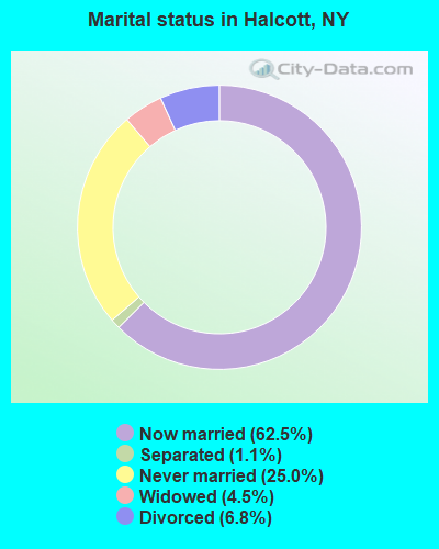
- Never married: 25.0%
- Now married: 62.5%
- Separated: 1.1%
- Widowed: 4.5%
- Divorced: 6.8%
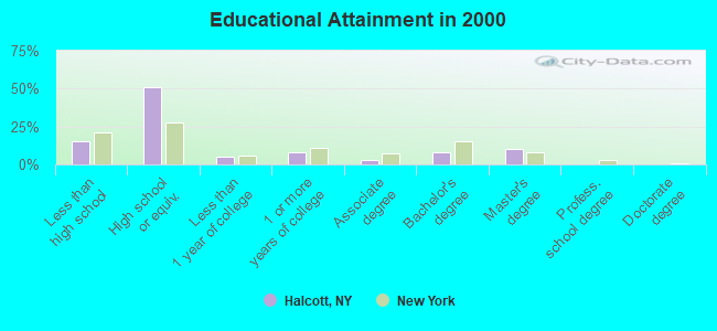
For population 25 years and over in Halcott:
- High school or higher: 85.0%
- Bachelor's degree or higher: 18.3%
- Graduate or professional degree: 10.5%
- Unemployed: 2.1%
- Mean travel time to work (commute): 40.1 minutes
| Here: | 9.6 |
| New York average: | 14.2 |

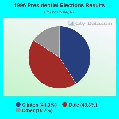
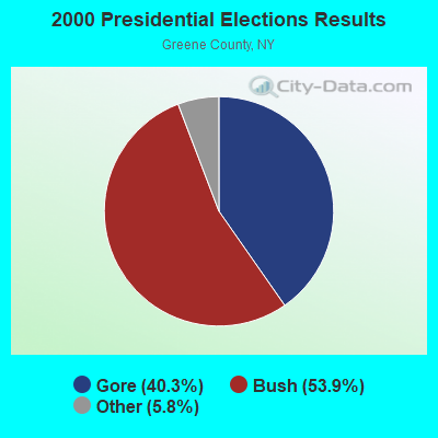
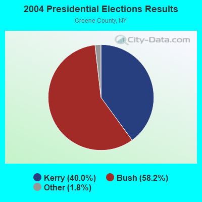
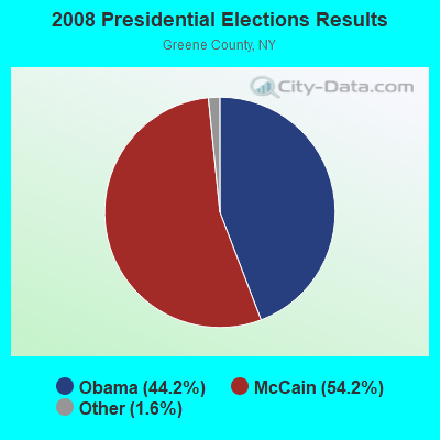
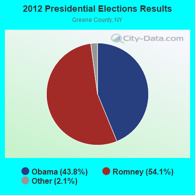
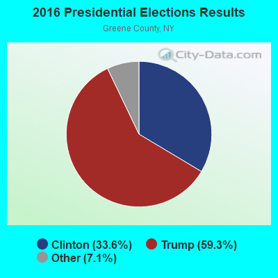

Graphs represent county-level data. Detailed 2008 Election Results
Religion statistics for Halcott, NY (based on Greene County data)
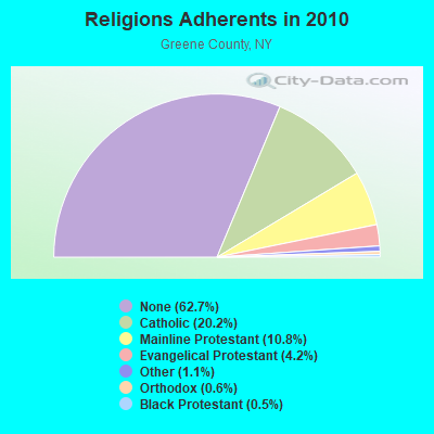
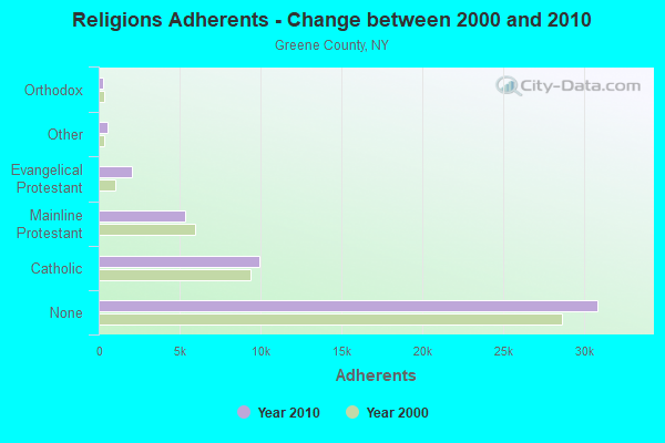
| Religion | Adherents | Congregations |
|---|---|---|
| Catholic | 9,935 | 9 |
| Mainline Protestant | 5,329 | 34 |
| Evangelical Protestant | 2,063 | 19 |
| Other | 520 | 7 |
| Orthodox | 280 | 1 |
| Black Protestant | 232 | 2 |
| None | 30,862 | - |
Food Environment Statistics:
| Here: | 2.65 / 10,000 pop. |
| State: | 4.13 / 10,000 pop. |
| Greene County: | 1.02 / 10,000 pop. |
| New York: | 0.92 / 10,000 pop. |
| This county: | 5.71 / 10,000 pop. |
| New York: | 1.68 / 10,000 pop. |
| Here: | 16.92 / 10,000 pop. |
| State: | 8.82 / 10,000 pop. |
| Here: | 7.7% |
| New York: | 8.2% |
| Greene County: | 24.5% |
| State: | 23.8% |
| Here: | 16.5% |
| New York: | 15.6% |
Strongest AM radio stations in Halcott:
- WGY (810 AM; 50 kW; SCHENECTADY, NY; Owner: CLEAR CHANNEL BROADCASTING LICENSES, INC.)
- WPTR (1540 AM; 50 kW; ALBANY, NY; Owner: KIMTRON, INC.)
- WNNZ (640 AM; 50 kW; WESTFIELD, MA; Owner: CLEAR CHANNEL BROADCASTING LICENSES, INC.)
- WMCA (570 AM; 50 kW; NEW YORK, NY; Owner: SALEM MEDIA OF NEW YORK, LLC)
- WFAN (660 AM; 50 kW; NEW YORK, NY; Owner: INFINITY BROADCASTING OPERATIONS, INC.)
- WABC (770 AM; 50 kW; NEW YORK, NY; Owner: WABC-AM RADIO, INC.)
- WOR (710 AM; 50 kW; NEW YORK, NY; Owner: BUCKLEY BROADCASTING CORPORATION)
- WCBS (880 AM; 50 kW; NEW YORK, NY; Owner: INFINITY BROADCASTING OPERATIONS, INC.)
- WTIC (1080 AM; 50 kW; HARTFORD, CT; Owner: INFINITY RADIO OPERATIONS INC.)
- WINS (1010 AM; 50 kW; NEW YORK, NY; Owner: INFINITY BROADCASTING OPERATIONS, INC.)
- WEPN (1050 AM; 50 kW; NEW YORK, NY; Owner: NEW YORK AM RADIO, LLC)
- WGHQ (920 AM; 5 kW; KINGSTON, NY; Owner: CLEVELAND RADIO LICENSES, LLC)
- WBBR (1130 AM; 50 kW; NEW YORK, NY; Owner: BLOOMBERG COMMUNICATIONS INC.)
Strongest FM radio stations in Halcott:
- WGKR (105.3 FM; GRAND GORGE, NY; Owner: SOUND OF LIFE, INC.)
- WRIP (97.9 FM; WINDHAM, NY; Owner: RIP RADIO, LLC)
- WAMK (90.9 FM; KINGSTON, NY; Owner: W A M C)
- WFGB (89.7 FM; KINGSTON, NY; Owner: SOUND OF LIFE, INC.)
- WFKP (99.3 FM; ELLENVILLE, NY; Owner: CLEAR CHANNEL BROADCASTING LICENSES, INC.)
- WDHI (100.3 FM; DELHI, NY; Owner: BANJO COMMUNICATIONS GROUP, INC.)
- WPDH (101.5 FM; POUGHKEEPSIE, NY; Owner: CUMULUS LICENSING CORP.)
- WAJZ (96.3 FM; VOORHEESVILLE, NY; Owner: 6 JOHNSON ROAD LICENSES, INC.)
- WFNP (88.7 FM; ROSENDALE, NY; Owner: STATE UNIVERSITY OF NEW YORK)
- WRHV (88.7 FM; POUGHKEEPSIE, NY; Owner: WMHT EDUCATIONAL TELECOMMUNICATIONS)
- WMYY (97.3 FM; SCHOHARIE, NY; Owner: CAPITAL MEDIA CORPORATION)
- WZMR (104.9 FM; ALTAMONT, NY; Owner: 6 JOHNSON ROAD LICENSES, INC.)
- WYJB (95.5 FM; ALBANY, NY; Owner: 6 JOHNSON ROAD LICENSES, INC.)
- WGNA-FM (107.7 FM; ALBANY, NY; Owner: REGENT LICENSEE OF MANSFIELD, INC.)
- WCZX (97.7 FM; HYDE PARK, NY; Owner: CUMULUS LICENSING CORP.)
- WMHT-FM (89.1 FM; SCHENECTADY, NY; Owner: WMHT EDUCATIONAL TELECOMMUNICATIONS)
- WRRB (96.9 FM; ARLINGTON, NY; Owner: CUMULUS LICENSING CORP.)
- WRVE (99.5 FM; SCHENECTADY, NY; Owner: CLEAR CHANNEL BROADCASTING LICENSES, INC.)
- WJIV (101.9 FM; CHERRY VALLEY, NY; Owner: CHRISTIAN BROADCASTING SYSTEM, LTD.)
- WPYX (106.5 FM; ALBANY, NY; Owner: CAPSTAR TX LIMITED PARTNERSHIP)
- National Bridge Inventory (NBI) Statistics
- 3Number of bridges
- 16ft / 5.1mTotal length
- $2,440,000Total costs
- 209Total average daily traffic
- 11Total average daily truck traffic
- 293Total future (year 2036) average daily traffic
FCC Registered Amateur Radio Licenses:
1- Call Sign: KB2NIP, Licensee ID: L00345847, Grant Date: 04/11/2001, Expiration Date: 07/09/2011, Cancellation Date: 07/10/2013, Registrant: Michael Di Benedetto, Box 73, Halcott, NY 12430
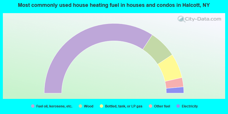
- 68.6%Fuel oil, kerosene, etc.
- 12.9%Wood
- 11.4%Bottled, tank, or LP gas
- 4.3%Other fuel
- 2.9%Electricity
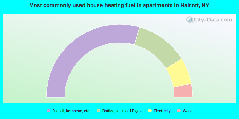
- 58.8%Fuel oil, kerosene, etc.
- 23.5%Bottled, tank, or LP gas
- 11.8%Electricity
- 5.9%Wood
Halcott compared to New York state average:
- Unemployed percentage significantly below state average.
- Black race population percentage significantly below state average.
- Hispanic race population percentage significantly below state average.
- Median age significantly above state average.
- Foreign-born population percentage below state average.
- Renting percentage significantly below state average.
- Length of stay since moving in significantly above state average.
- Number of rooms per house significantly below state average.
- House age significantly below state average.
- Number of college students significantly below state average.
- Percentage of population with a bachelor's degree or higher below state average.