Freedom, New York
Submit your own pictures of this town and show them to the world
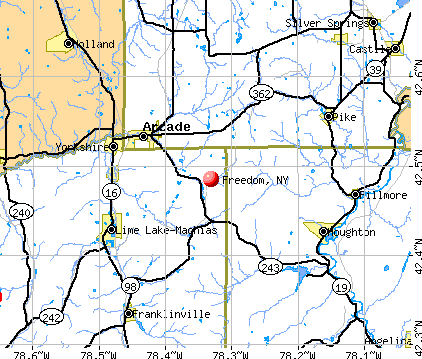
- OSM Map
- General Map
- Google Map
- MSN Map
Population change since 2000: -3.5%
 |
| Males: 1,238 | |
| Females: 1,167 |
| Median resident age: | 41.3 years |
| New York median age: | 40.7 years |
Zip codes: 14065.
| Freedom: | $52,398 |
| NY: | $79,557 |
Estimated per capita income in 2022: $26,529 (it was $14,145 in 2000)
Freedom town income, earnings, and wages data
Estimated median house or condo value in 2022: $122,844 (it was $66,800 in 2000)
| Freedom: | $122,844 |
| NY: | $400,400 |
Mean prices in 2022: all housing units: $146,086; detached houses: $161,917; townhouses or other attached units: $256,277; in 2-unit structures: $129,405; in 3-to-4-unit structures: $161,674; in 5-or-more-unit structures: $139,490; mobile homes: $56,988; occupied boats, rvs, vans, etc.: $97,187
Detailed information about poverty and poor residents in Freedom, NY

Compare current foreclosures near Freedom, NY:
| Photo | Address | Area | Beds / Baths | Price | Details |
|---|---|---|---|---|---|

|
#1
Brown Schoolhouse Rd
Freedom, NY 14065
|
1,664 sq. feet
|
2 baths 3 beds |
show details | |

|
#2
Freedom Rd
Freedom, NY 14065
|
1,749 sq. feet
|
1 baths 4 beds |
show details | |

|
#3
Sparks Rd
Freedom, NY 14065
|
1,280 sq. feet
|
- baths - beds |
show details | |

|
#4
Mutton Hollow Rd
Freedom, NY 14065
|
- sq. feet
|
- baths - beds |
show details | |

|
#5
Route 98
Freedom, NY 14065
|
- sq. feet
|
- baths - beds |
show details | |

|
#6
Phillippi Rd
Freedom, NY 14065
|
- sq. feet
|
- baths - beds |
show details | |

|
#7
Cattaraugus St
Springville, NY 14141
|
1,424 sq. feet
|
1 baths 3 beds |
$249,900
|
show details |

|
#8
Curriers Rd
Arcade, NY 14009
|
1,464 sq. feet
|
1 baths 3 beds |
show details | |

|
#9
County Road 23
Houghton, NY 14744
|
1,296 sq. feet
|
1 baths 3 beds |
show details | |

|
#10
Sisson Rd
Machias, NY 14101
|
1,332 sq. feet
|
1 baths 2 beds |
show details |
| Photo | Address | Area | Beds / Baths | Price | Details |
|---|---|---|---|---|---|

|
#11
2nd Ave
Franklinville, NY 14737
|
1,200 sq. feet
|
1 baths 3 beds |
show details | |

|
#12
Pine St
Franklinville, NY 14737
|
2,182 sq. feet
|
2 baths 6 beds |
show details | |

|
#13
Howard St
Franklinville, NY 14737
|
1,056 sq. feet
|
1 baths 2 beds |
show details | |

|
#14
Howard St
Franklinville, NY 14737
|
1,117 sq. feet
|
1 baths 3 beds |
show details | |

|
#15
Timelessview Dr
Chaffee, NY 14030
|
1,410 sq. feet
|
2 baths 3 beds |
show details | |

|
#16
1st Ave
Franklinville, NY 14737
|
1,899 sq. feet
|
1 baths 4 beds |
show details | |

|
#17
Maple Ave
Franklinville, NY 14737
|
1,536 sq. feet
|
1 baths 2 beds |
show details | |

|
#18
Chestnut St
Franklinville, NY 14737
|
2,788 sq. feet
|
1 baths 4 beds |
show details | |

|
#19
Savage Rd
Chaffee, NY 14030
|
1,086 sq. feet
|
1 baths 3 beds |
show details | |

|
#20
2nd Ave
Franklinville, NY 14737
|
1,760 sq. feet
|
1 baths 3 beds |
show details |
| Photo | Address | Area | Beds / Baths | Price | Details |
|---|---|---|---|---|---|

|
#21
Genesee Rd
East Concord, NY 14055
|
1,344 sq. feet
|
1 baths 3 beds |
show details | |

|
#22
Yacht Club Dr
Machias, NY 14101
|
1,300 sq. feet
|
2 baths 3 beds |
show details | |

|
#23
Riceville Rd
West Valley, NY 14171
|
1,264 sq. feet
|
1 baths 3 beds |
show details | |

|
#24
S Protection Rd
Holland, NY 14080
|
1,152 sq. feet
|
1 baths 2 beds |
show details | |

|
#25
Cadiz Rd
Franklinville, NY 14737
|
1,584 sq. feet
|
1 baths 3 beds |
show details | |

|
#26
Depot St
West Valley, NY 14171
|
2,712 sq. feet
|
1 baths 2 beds |
show details | |

|
#27
Stady Rd
West Valley, NY 14171
|
1,560 sq. feet
|
1 baths 3 beds |
show details | |

|
#28
Baxter Mills Rd
Hinsdale, NY 14743
|
1,800 sq. feet
|
1 baths 3 beds |
show details | |

|
#29
Dutch Hill Rd
West Valley, NY 14171
|
1,368 sq. feet
|
1 baths 3 beds |
show details | |

|
#30
Route 240
Ellicottville, NY 14731
|
2,496 sq. feet
|
1 baths 5 beds |
show details |
| Photo | Address | Area | Beds / Baths | Price | Details |
|---|---|---|---|---|---|

|
#31
Mckinstry Rd
Machias, NY 14101
|
1,668 sq. feet
|
2 baths 3 beds |
show details | |

|
#32
Route 305
Cuba, NY 14727
|
1,687 sq. feet
|
1 baths 3 beds |
show details | |

|
#33
Marble Rd
Delevan, NY 14042
|
2,040 sq. feet
|
2 baths 3 beds |
show details | |

|
#34
Maple St
Arcade, NY 14009
|
2,240 sq. feet
|
2 baths 5 beds |
show details | |

|
#35
Hughes Rd
Arcade, NY 14009
|
1,848 sq. feet
|
2 baths 4 beds |
show details | |

|
#36
Delevan Elton Rd
Delevan, NY 14042
|
806 sq. feet
|
1 baths 2 beds |
show details | |

|
#37
Osmun Rd
Farmersville Station, NY 14060
|
720 sq. feet
|
2 baths 4 beds |
show details | |

|
#38
Maple Ave
Machias, NY 14101
|
910 sq. feet
|
- baths 3 beds |
show details | |

|
#39
Huyck Rd
Franklinville, NY 14737
|
980 sq. feet
|
- baths 4 beds |
show details | |

|
#40
Westover Rd
Yorkshire, NY 14173
|
- sq. feet
|
- baths - beds |
show details |
| Photo | Address | Area | Beds / Baths | Price | Details |
|---|---|---|---|---|---|

|
#41
Sunset Hill Rd
Machias, NY 14101
|
- sq. feet
|
- baths - beds |
show details | |

|
#42
Route 240
West Valley, NY 14171
|
- sq. feet
|
- baths - beds |
show details | |

|
#43
Hillview Dr
West Valley, NY 14171
|
600 sq. feet
|
- baths - beds |
show details | |

|
#44
Bakerstand Rd
Machias, NY 14101
|
720 sq. feet
|
- baths - beds |
show details | |

|
#45
Roszyk Hill Rd
Machias, NY 14101
|
- sq. feet
|
- baths - beds |
show details | |

|
#46
Town Line Rd
Franklinville, NY 14737
|
320 sq. feet
|
- baths - beds |
show details | |

|
#47
Route 240
West Valley, NY 14171
|
- sq. feet
|
- baths - beds |
show details | |

|
#48
Slab City Rd
Franklinville, NY 14737
|
128 sq. feet
|
- baths - beds |
show details | |

|
#49
Cagwin Rd
Delevan, NY 14042
|
- sq. feet
|
- baths - beds |
show details | |

|
Check over 1 million property listings on Foreclosure.com!
|
browse all offers | |||

- 2,34497.5%White alone
- 281.2%Hispanic
- 170.7%Two or more races
- 110.5%Asian alone
- 40.2%Black alone
- 10.04%American Indian alone
Races in Freedom detailed stats: ancestries, foreign born residents, place of birth
According to our research of New York and other state lists, there were 3 registered sex offenders living in Freedom, New York as of May 18, 2024.
The ratio of all residents to sex offenders in Freedom is 802 to 1.
The ratio of registered sex offenders to all residents in this city is near the state average.
 Recent articles from our blog. Our writers, many of them Ph.D. graduates or candidates, create easy-to-read articles on a wide variety of topics.

 | Freedom Plaza the Hudson Yards of East River ? (0 replies) |
| COVID-19 hospitalizations in New York on the rise again (521 replies) |
| Upper Middle class african-american communities in ny (2049 replies) |
| Violent incident at Grand Central Station this afternoon (31 replies) |
| A Bar In East Village Still Doing Vaccine Checks (85 replies) |
| SCOTUS Handgun Decision! (68 replies) |
Latest news from Freedom, NY collected exclusively by city-data.com from local newspapers, TV, and radio stations
Ancestries: German (34.6%), English (15.7%), Irish (13.5%), Polish (10.5%), United States (7.4%), Italian (7.1%).
Current Local Time: EST time zone
Land area: 40.3 square miles.
Population density: 60 people per square mile (very low).
21 residents are foreign born
| This town: | 0.8% |
| New York: | 20.4% |
| Freedom town: | 1.9% ($1,276) |
| New York: | 1.9% ($2,847) |
Nearest city with pop. 50,000+: Cheektowaga, NY  (36.4 miles , pop. 79,988).
Nearest city with pop. 200,000+: Buffalo, NY (38.7 miles , pop. 292,648).
Nearest city with pop. 1,000,000+: Philadelphia, PA (239.5 miles , pop. 1,517,550).
Nearest cities:
), ), ), ), Latitude: 42.47 N, Longitude: 78.36 W

Single-family new house construction building permits:
- 2018: 1 building, cost: $60,000
- 2017: 2 buildings, average cost: $243,100
- 2014: 3 buildings, average cost: $147,000
- 2012: 3 buildings, average cost: $73,700
- 2011: 2 buildings, average cost: $176,300
- 2010: 5 buildings, average cost: $63,200
- 2009: 1 building, cost: $202,000
- 2008: 8 buildings, average cost: $61,400
- 2007: 7 buildings, average cost: $67,500
- 2006: 17 buildings, average cost: $50,900
- 2005: 3 buildings, average cost: $103,300
- 2004: 9 buildings, average cost: $92,500
- 2003: 12 buildings, average cost: $108,300
- 2002: 12 buildings, average cost: $74,800
- 2001: 21 buildings, average cost: $52,500
- 2000: 21 buildings, average cost: $56,100
- 1999: 25 buildings, average cost: $43,700
- 1998: 33 buildings, average cost: $38,200
- 1997: 20 buildings, average cost: $90,300
| Here: | 4.9% |
| New York: | 4.4% |
- Construction (11.2%)
- Transportation equipment (7.1%)
- Health care (7.0%)
- Accommodation & food services (6.3%)
- Metal & metal products (6.3%)
- Agriculture, forestry, fishing & hunting (5.2%)
- Machinery (4.2%)
- Construction (18.0%)
- Metal & metal products (8.9%)
- Transportation equipment (7.9%)
- Agriculture, forestry, fishing & hunting (6.5%)
- Repair & maintenance (6.4%)
- Machinery (5.2%)
- Accommodation & food services (3.8%)
- Health care (14.5%)
- Accommodation & food services (9.8%)
- Educational services (7.9%)
- Transportation equipment (6.1%)
- Social assistance (4.9%)
- Food & beverage stores (4.4%)
- Public administration (3.7%)
- Other production occupations, including supervisors (9.0%)
- Metal workers and plastic workers (5.9%)
- Vehicle and mobile equipment mechanics, installers, and repairers (4.8%)
- Assemblers and fabricators (4.2%)
- Electrical equipment mechanics and other installation, maintenance, and repair workers, including supervisors (4.1%)
- Material recording, scheduling, dispatching, and distributing workers (3.9%)
- Driver/sales workers and truck drivers (3.5%)
- Other production occupations, including supervisors (12.7%)
- Metal workers and plastic workers (9.5%)
- Vehicle and mobile equipment mechanics, installers, and repairers (8.4%)
- Driver/sales workers and truck drivers (6.0%)
- Electrical equipment mechanics and other installation, maintenance, and repair workers, including supervisors (5.7%)
- Other management occupations, except farmers and farm managers (5.0%)
- Construction traders workers except carpenters, electricians, painters, plumbers, and construction laborers (4.8%)
- Health technologists and technicians (7.0%)
- Other sales and related occupations, including supervisors (4.9%)
- Assemblers and fabricators (4.9%)
- Other food preparation and serving workers, including supervisors (4.7%)
- Other office and administrative support workers, including supervisors (4.7%)
- Bookkeeping, accounting, and auditing clerks (4.4%)
- Material recording, scheduling, dispatching, and distributing workers (4.4%)
Average climate in Freedom, New York
Based on data reported by over 4,000 weather stations


Tornado activity:
Freedom-area historical tornado activity is near New York state average. It is 63% smaller than the overall U.S. average.
On 7/24/1967, a category F3 (max. wind speeds 158-206 mph) tornado 11.3 miles away from the Freedom town center caused between $5000 and $50,000 in damages.
On 6/20/1969, a category F3 tornado 19.3 miles away from the town center caused between $500,000 and $5,000,000 in damages.
Earthquake activity:
Freedom-area historical earthquake activity is significantly above New York state average. It is 66% smaller than the overall U.S. average.On 9/25/1998 at 19:52:52, a magnitude 5.2 (4.8 MB, 4.3 MS, 5.2 LG, 4.5 MW, Depth: 3.1 mi, Class: Moderate, Intensity: VI - VII) earthquake occurred 124.6 miles away from the city center
On 1/31/1986 at 16:46:43, a magnitude 5.0 (5.0 MB) earthquake occurred 155.7 miles away from the city center
On 8/23/2011 at 17:51:04, a magnitude 5.8 (5.8 MW, Depth: 3.7 mi) earthquake occurred 316.5 miles away from the city center
On 10/7/1983 at 10:18:46, a magnitude 5.3 (5.1 MB, 5.3 LG, 5.1 ML) earthquake occurred 227.1 miles away from the city center
On 4/20/2002 at 10:50:47, a magnitude 5.3 (5.3 ML, Depth: 3.0 mi) earthquake occurred 273.3 miles away from Freedom center
On 4/20/2002 at 10:50:47, a magnitude 5.2 (5.2 MB, 4.2 MS, 5.2 MW, 5.0 MW) earthquake occurred 271.6 miles away from the city center
Magnitude types: regional Lg-wave magnitude (LG), body-wave magnitude (MB), local magnitude (ML), surface-wave magnitude (MS), moment magnitude (MW)
Natural disasters:
The number of natural disasters in Cattaraugus County (23) is greater than the US average (15).Major Disasters (Presidential) Declared: 14
Emergencies Declared: 9
Causes of natural disasters: Storms: 11, Floods: 10, Snowstorms: 4, Hurricanes: 2, Winter Storms: 2, Blizzard: 1, Ice Storm: 1, Power Outage: 1, Snow: 1, Tornado: 1, Tropical Storm: 1, Other: 2 (Note: some incidents may be assigned to more than one category).

Colleges/universities with over 2000 students nearest to Freedom:
- St Bonaventure University (about 28 miles; Saint Bonaventure, NY; Full-time enrollment: 2,286)
- Bryant & Stratton College-Online (about 31 miles; Orchard Park, NY; FT enrollment: 2,212)
- SUNY College of Technology at Alfred (about 33 miles; Alfred, NY; FT enrollment: 3,483)
- Alfred University (about 34 miles; Alfred, NY; FT enrollment: 2,411)
- SUNY College at Geneseo (about 36 miles; Geneseo, NY; FT enrollment: 5,520)
- Erie Community College (about 39 miles; Buffalo, NY; FT enrollment: 11,035)
- Genesee Community College (about 40 miles; Batavia, NY; FT enrollment: 4,290)
Points of interest:
Notable locations in Freedom: Scouthaven Camp (A), Elton Station (B), Edelweiss Farms (C), Camp Vick (D), Turkey Run Golf Course (E). Display/hide their locations on the map
Churches in Freedom include: Salem Church (A), Sandusky Baptist Church (B). Display/hide their locations on the map
Cemeteries: Siloam Cemetery (1), Elton Cemetery (2), Sandusky Cemetery (3), Salem Cemetery (4), Freedom Cemetery (5), Maple Grove Cemetery (6). Display/hide their locations on the map
Lakes and swamps: Moores Pond (A), Skim Lake (B), Beaver Lake (C), Crystal Lake (D), Burleson Pond (E). Display/hide their locations on the map
| This town: | 2.7 people |
| New York: | 2.6 people |
| This town: | 75.4% |
| Whole state: | 63.5% |
| This town: | 9.1% |
| Whole state: | 6.8% |
Likely homosexual households (counted as self-reported same-sex unmarried-partner households)
- Lesbian couples: 0.2% of all households
- Gay men: 0.3% of all households
| This town: | 11.3% |
| Whole state: | 14.6% |
| This town: | 1.4% |
| Whole state: | 7.4% |
4 people in homes for the mentally retarded in 2000
For population 15 years and over in Freedom:
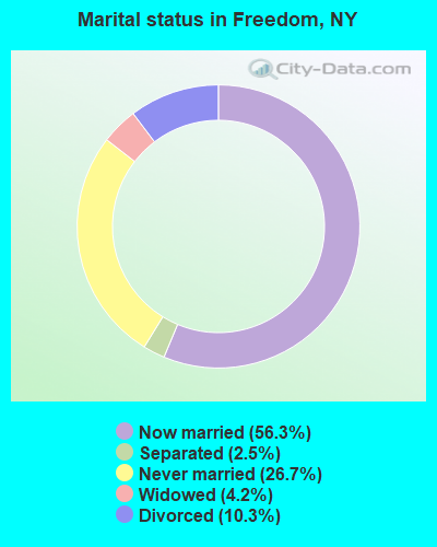
- Never married: 26.7%
- Now married: 56.3%
- Separated: 2.5%
- Widowed: 4.2%
- Divorced: 10.3%
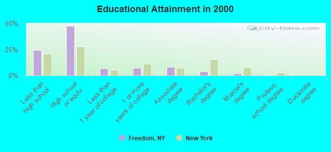
For population 25 years and over in Freedom:
- High school or higher: 75.5%
- Bachelor's degree or higher: 5.9%
- Graduate or professional degree: 2.2%
- Unemployed: 14.0%
- Mean travel time to work (commute): 29.5 minutes
| Here: | 9.4 |
| New York average: | 14.2 |
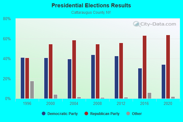
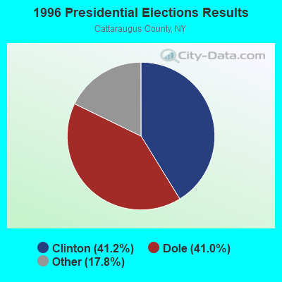
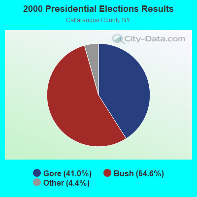
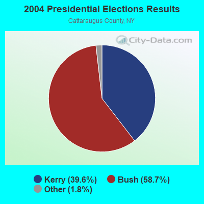
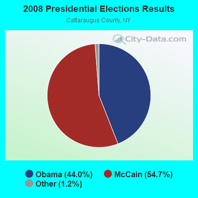

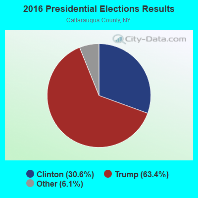
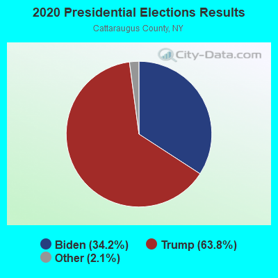
Graphs represent county-level data. Detailed 2008 Election Results
Religion statistics for Freedom, NY (based on Cattaraugus County data)
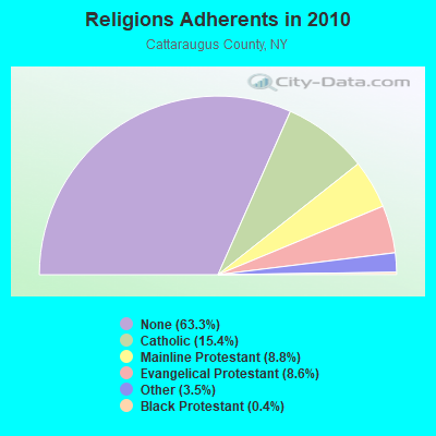
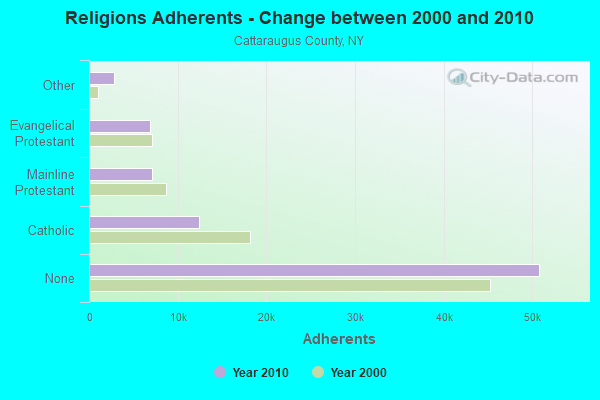
| Religion | Adherents | Congregations |
|---|---|---|
| Catholic | 12,351 | 12 |
| Mainline Protestant | 7,090 | 49 |
| Evangelical Protestant | 6,923 | 71 |
| Other | 2,843 | 12 |
| Black Protestant | 305 | 2 |
| None | 50,805 | - |
Food Environment Statistics:
| Cattaraugus County: | 2.62 / 10,000 pop. |
| State: | 4.13 / 10,000 pop. |
| Here: | 0.12 / 10,000 pop. |
| State: | 0.06 / 10,000 pop. |
| This county: | 1.12 / 10,000 pop. |
| New York: | 0.92 / 10,000 pop. |
| Cattaraugus County: | 3.87 / 10,000 pop. |
| State: | 1.68 / 10,000 pop. |
| This county: | 9.48 / 10,000 pop. |
| State: | 8.82 / 10,000 pop. |
| Cattaraugus County: | 9.5% |
| New York: | 8.2% |
| Cattaraugus County: | 28.5% |
| State: | 23.8% |
| Cattaraugus County: | 16.7% |
| New York: | 15.6% |
Strongest AM radio stations in Freedom:
- WWKB (1520 AM; 50 kW; BUFFALO, NY; Owner: ENTERCOM BUFFALO LICENSE, LLC)
- WHAM (1180 AM; 50 kW; ROCHESTER, NY; Owner: CITICASTERS LICENSES, L.P.)
- WGR (550 AM; 5 kW; BUFFALO, NY; Owner: ENTERCOM BUFFALO LICENSE, LLC)
- WNED (970 AM; 5 kW; BUFFALO, NY)
- WCJW (1140 AM; daytime; 2 kW; WARSAW, NY; Owner: LLOYD LANE, INCORPORATED)
- WGGO (1590 AM; 5 kW; SALAMANCA, NY; Owner: CATT COMMUNICATIONS, INC.)
- WXRL (1300 AM; 5 kW; LANCASTER, NY; Owner: DOME BROADCASTING, INC.)
- WHLD (1270 AM; 5 kW; NIAGARA FALLS, NY; Owner: CITADEL BROADCASTING COMPANY)
- WTOR (770 AM; daytime; 9 kW; YOUNGSTOWN, NY; Owner: BIRACH BROADCASTING CORPORATION)
- WSPQ (1330 AM; 1 kW; SPRINGVILLE, NY; Owner: HAWK COMMUNICATIONS, LTD.)
- WHHO (1320 AM; 5 kW; HORNELL, NY; Owner: BILBAT RADIO, INC.)
- WBEN (930 AM; 5 kW; BUFFALO, NY; Owner: ENTERCOM BUFFALO LICENSE, LLC)
- WABH (1380 AM; 10 kW; BATH, NY)
Strongest FM radio stations in Freedom:
- WNSA (107.7 FM; WETHERSFIELD TWNSHP, NY; Owner: ADELPHIA COMMUNICATIONS CORPORATION, DEBTOR-IN-POSSESSION)
- WTSS (102.5 FM; BUFFALO, NY; Owner: ENTERCOM BUFFALO LICENSE, LLC)
- WBUF (92.9 FM; BUFFALO, NY; Owner: INFINITY RADIO OPERATIONS INC.)
- WNED-FM (94.5 FM; BUFFALO, NY; Owner: WESTERN NEW YORK PUBLIC B/C ASSOC.)
- WDCX (99.5 FM; BUFFALO, NY; Owner: KIMTRON, INC.)
- WJSL (90.3 FM; HOUGHTON, NY; Owner: WXXI PUBLIC BROADCASTING COUNCIL)
- WPIG (95.7 FM; OLEAN, NY; Owner: ARROW COMMUNICATIONS OF N.Y., INC.)
- WZKZ (101.9 FM; ALFRED, NY; Owner: PEMBROOK PINES ELMIRA, LTD.)
- WCOU (88.3 FM; WARSAW, NY; Owner: FAMILY LIFE MINISTRIES, INC.)
- WQRT (98.3 FM; SALAMANCA, NY; Owner: CATT COMMUNICATIONS, INC.)
- WOLN (91.3 FM; OLEAN, NY; Owner: STATE UNIVERSITY OF NEW YORK)
- WCID (89.1 FM; FRIENDSHIP, NY; Owner: FAMILY LIFE MINISTRIES, INC.)
- WFBF (89.9 FM; BUFFALO, NY; Owner: FAMILY STATIONS, INC.)
- WDNY-FM (93.9 FM; DANSVILLE, NY; Owner: MILLER MEDIA INC.)
- WLOF (101.7 FM; ATTICA, NY; Owner: HOLY FAMILY COMMUNICATIONS, INC.)
- WJQZ (103.5 FM; WELLSVILLE, NY; Owner: DBM COMMUNICATIONS, INC.)
- WMXO (101.5 FM; OLEAN, NY; Owner: VOX ALLEGANY, LLC)
- W213BC (90.5 FM; OLEAN, NY; Owner: FAMILY LIFE MINISTRIES, INC.)
TV broadcast stations around Freedom:
- WKBW-TV (Channel 7; BUFFALO, NY; Owner: WKBW-TV LICENSE, INC.)
- WNGS (Channel 67; SPRINGVILLE, NY; Owner: CAROLINE K. POWLEY D/B/A UNICORN/SPRINGVILLE)
- WGRZ-TV (Channel 2; BUFFALO, NY; Owner: MULTIMEDIA ENTERTAINMENT, INC.)
- WIVB-TV (Channel 4; BUFFALO, NY; Owner: WIVB BROADCASTING, LLC)
- WNYO-TV (Channel 49; BUFFALO, NY; Owner: NEW YORK TELEVISION, INC.)
- WPXJ-TV (Channel 51; BATAVIA, NY; Owner: PAXSON BUFFALO LICENSE, INC.)
- WNYB (Channel 26; JAMESTOWN, NY; Owner: FAITH BROADCASTING NETWORK, INC.)
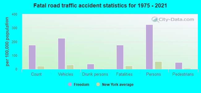
Freedom fatal accident list:
Apr 11, 2003 10:25 PM, Bixby Hill Road, Vehicles: 1, Persons: 1, Fatalities: 1, Drunk persons involved: 1
Apr 29, 1998 05:35 PM, Cr-90, Vehicles: 2, Persons: 3, Fatalities: 1
Aug 29, 1998 06:10 AM, Sr-98, Vehicles: 1, Persons: 2, Pedestrians: 1, Fatalities: 1
- National Bridge Inventory (NBI) Statistics
- 21Number of bridges
- 148ft / 44.7mTotal length
- $38,500,000Total costs
- 19,684Total average daily traffic
- 2,544Total average daily truck traffic
- 22,080Total future (year 2036) average daily traffic
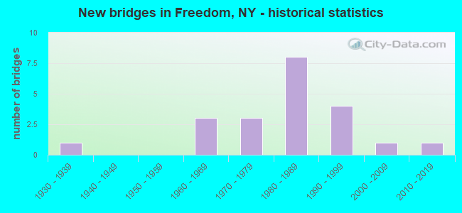
- New bridges - historical statistics
- 11930-1939
- 31960-1969
- 31970-1979
- 81980-1989
- 41990-1999
- 12000-2009
- 12010-2019
FCC Registered Antenna Towers:
24 (See the full list of FCC Registered Antenna Towers in Freedom)FCC Registered Broadcast Land Mobile Towers:
1- Arcade Elton Rd 2.8 Km S Arcade (Lat: 42.503944 Lon: -78.432528), Type: Pole, Structure height: 21 m, Overall height: 23 m, Call Sign: KED377, Licensee ID: L00001988,
Assigned Frequencies: 48.1800 MHz, 48.7400 MHz, 47.9400 MHz, 48.1400 MHz, Grant Date: 01/13/2023, Expiration Date: 03/09/2033, Certifier: John A Rimlinger, Registrant: National Fuel Distribution Corporation, 365 Mineral Spring Rd, Buffalo, NY 14210, Phone: (716) 827-5512, Fax: (716) 827-2317, Email:
FCC Registered Microwave Towers:
10 (See the full list of FCC Registered Microwave Towers in this town)FCC Registered Amateur Radio Licenses:
20 (See the full list of FCC Registered Amateur Radio Licenses in Freedom)FAA Registered Aircraft:
1- Aircraft: PIPER PA-22-108 (Category: Land, Seats: 2, Weight: Up to 12,499 Pounds, Speed: 94 mph), Engine: LYCOMING 0-235 SERIES (115 HP) (Reciprocating)
N-Number: 5875Z, N5875Z, N-5875Z, Serial Number: 22-9733, Year manufactured: 1963, Airworthiness Date: 10/10/1963, Certificate Issue Date: 12/02/2003
Registrant (Individual): Rusty D Smith, 11020 Mcmurray Rd, Freedom, NY 14065
| Most common first names in Freedom, NY among deceased individuals | ||
| Name | Count | Lived (average) |
|---|---|---|
| John | 6 | 72.5 years |
| Robert | 6 | 53.4 years |
| Ruth | 6 | 81.1 years |
| Clifford | 5 | 79.6 years |
| Edward | 5 | 73.0 years |
| Charles | 5 | 73.8 years |
| Frank | 4 | 73.0 years |
| Eleanor | 4 | 73.5 years |
| Mary | 4 | 71.0 years |
| Ronald | 4 | 63.7 years |
| Most common last names in Freedom, NY among deceased individuals | ||
| Last name | Count | Lived (average) |
|---|---|---|
| Leonard | 6 | 72.5 years |
| Morgan | 4 | 71.7 years |
| Newland | 4 | 75.2 years |
| Howlett | 4 | 80.0 years |
| Hatch | 3 | 68.3 years |
| Frazier | 3 | 76.0 years |
| Crosby | 3 | 74.3 years |
| Makowski | 3 | 81.7 years |
| Phillippi | 3 | 72.6 years |
| Irish | 3 | 76.0 years |
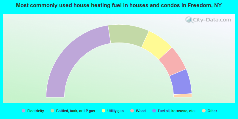
- 45.2%Electricity
- 18.3%Bottled, tank, or LP gas
- 12.4%Utility gas
- 11.4%Wood
- 11.1%Fuel oil, kerosene, etc.
- 1.1%Other fuel
- 0.5%No fuel used
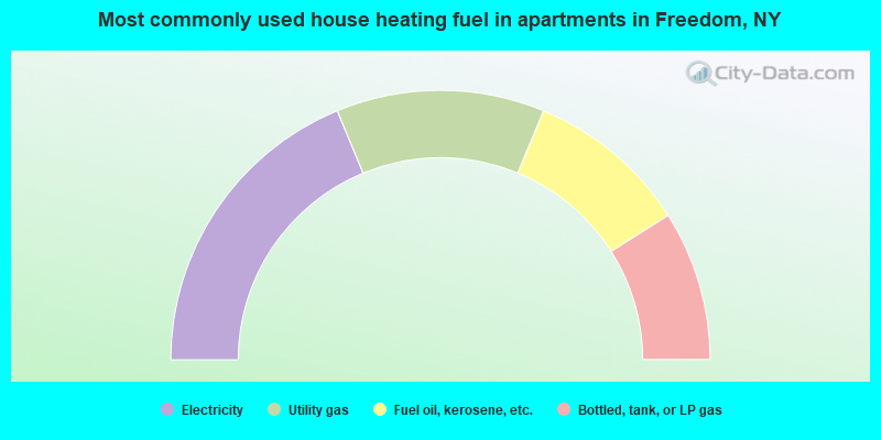
- 37.5%Electricity
- 25.0%Utility gas
- 19.5%Fuel oil, kerosene, etc.
- 18.0%Bottled, tank, or LP gas
Freedom compared to New York state average:
- Median household income below state average.
- Median house value significantly below state average.
- Black race population percentage significantly below state average.
- Hispanic race population percentage significantly below state average.
- Foreign-born population percentage significantly below state average.
- Renting percentage significantly below state average.
- Length of stay since moving in significantly above state average.
- Number of rooms per house significantly below state average.
- House age significantly below state average.
- Number of college students significantly below state average.
- Percentage of population with a bachelor's degree or higher significantly below state average.