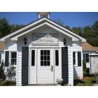
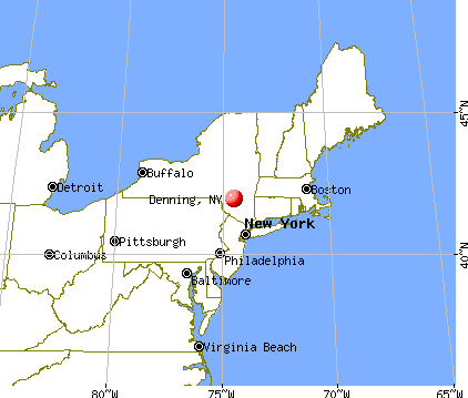
Denning, New York
Submit your own pictures of this town and show them to the world
- OSM Map
- General Map
- Google Map
- MSN Map
Population change since 2000: +6.8%
 |
| Males: 284 | |
| Females: 267 |
| Median resident age: | 46.2 years |
| New York median age: | 40.7 years |
Zip codes: 12740.
| Denning: | $77,240 |
| NY: | $79,557 |
Estimated per capita income in 2022: $52,536 (it was $23,846 in 2000)
Denning town income, earnings, and wages data
Estimated median house or condo value in 2022: $260,005 (it was $86,000 in 2000)
| Denning: | $260,005 |
| NY: | $400,400 |
Mean prices in 2022: all housing units: $379,181; detached houses: $393,684; townhouses or other attached units: $652,719; in 2-unit structures: $266,147; in 3-to-4-unit structures: $293,759; in 5-or-more-unit structures: $291,039; mobile homes: $115,808
Detailed information about poverty and poor residents in Denning, NY
Compare current foreclosures near Denning, NY:
| Photo | Address | Area | Beds / Baths | Price | Details |
|---|---|---|---|---|---|

|
#1
Wawanda Ave
Liberty, NY 12754
|
1,000 sq. feet
|
1 baths 2 beds |
$54,900
|
show details |

|
#2
Marion Ave
Liberty, NY 12754
|
1,044 sq. feet
|
2 baths 3 beds |
show details | |

|
#3
Irish Cape Rd
Napanoch, NY 12458
|
1,128 sq. feet
|
1 baths 2 beds |
show details | |

|
#4
Clay Hill Rd
Kerhonkson, NY 12446
|
1,244 sq. feet
|
1 baths 2 beds |
show details | |

|
#5
Highland Ave
Kerhonkson, NY 12446
|
1,012 sq. feet
|
1 baths 3 beds |
show details | |

|
#6
Mountain Rd
Shokan, NY 12481
|
1,272 sq. feet
|
1 baths 3 beds |
show details | |

|
#7
Center Street
Phoenicia, NY 12464
|
1,863 sq. feet
|
1 baths 2 beds |
show details | |

|
#8
Route 209
Kerhonkson, NY 12446
|
1,200 sq. feet
|
1 baths 3 beds |
show details | |

|
#9
County Road 2
Olivebridge, NY 12461
|
1,575 sq. feet
|
1 baths 3 beds |
show details | |

|
#10
Traver Hollow Rd
Boiceville, NY 12412
|
1,493 sq. feet
|
1 baths 2 beds |
show details |
| Photo | Address | Area | Beds / Baths | Price | Details |
|---|---|---|---|---|---|

|
#11
Schoolhouse Rd
Napanoch, NY 12458
|
1,512 sq. feet
|
2 baths 3 beds |
show details | |

|
#12
Big Hollow Rd
Grahamsville, NY 12740
|
2,410 sq. feet
|
2 baths 4 beds |
show details | |

|
#13
Sean St
Napanoch, NY 12458
|
1,456 sq. feet
|
2 baths 3 beds |
show details | |

|
#14
Twinshaven Rd
Napanoch, NY 12458
|
1,950 sq. feet
|
1 baths 3 beds |
show details | |

|
#15
Reservoir Rd
Shokan, NY 12481
|
1,673 sq. feet
|
1 baths 3 beds |
show details | |

|
#16
Terwilliger Rd
Kerhonkson, NY 12446
|
3,000 sq. feet
|
3 baths 4 beds |
show details | |

|
#17
Church St
Kerhonkson, NY 12446
|
1,776 sq. feet
|
2 baths 4 beds |
show details | |

|
#18
Mary Davis Rd
Accord, NY 12404
|
1,020 sq. feet
|
1 baths 3 beds |
show details | |

|
#19
State Route 55
Liberty, NY 12754
|
1,846 sq. feet
|
2 baths 4 beds |
show details | |

|
#20
Baker Rd
Bearsville, NY 12409
|
669 sq. feet
|
1 baths 1 beds |
show details |
| Photo | Address | Area | Beds / Baths | Price | Details |
|---|---|---|---|---|---|

|
#21
City Hall Rd
Kerhonkson, NY 12446
|
3,088 sq. feet
|
4 baths 6 beds |
show details | |

|
#22
Hall Rd
Margaretville, NY 12455
|
1,000 sq. feet
|
1 baths 1 beds |
show details | |

|
#23
Myers Rd
Neversink, NY 12765
|
1,728 sq. feet
|
1 baths 5 beds |
show details | |

|
#24
Samsonville Rd
Kerhonkson, NY 12446
|
864 sq. feet
|
1 baths 3 beds |
show details | |

|
#25
Route 28
Pine Hill, NY 12465
|
- sq. feet
|
1 baths 3 beds |
show details | |

|
#26
Deerfield Rd
Boiceville, NY 12412
|
1,400 sq. feet
|
3 baths 4 beds |
show details | |

|
#27
Liberty St
Liberty, NY 12754
|
2,076 sq. feet
|
2 baths 4 beds |
show details | |

|
#28
Maple Ave S
Woodridge, NY 12789
|
2,012 sq. feet
|
1 baths 3 beds |
show details | |

|
#29
Sages Loop
Kerhonkson, NY 12446
|
1,676 sq. feet
|
1 baths 3 beds |
show details | |

|
#30
Watson Hollow Rd
West Shokan, NY 12494
|
1,768 sq. feet
|
2 baths 3 beds |
show details |
| Photo | Address | Area | Beds / Baths | Price | Details |
|---|---|---|---|---|---|

|
#31
Dymond Rd
Grahamsville, NY 12740
|
2,880 sq. feet
|
2 baths 3 beds |
show details | |

|
#32
Phyllis Dr
Ellenville, NY 12428
|
1,039 sq. feet
|
1 baths - beds |
show details | |

|
#33
Terrie St
Ellenville, NY 12428
|
1,596 sq. feet
|
1 baths - beds |
show details | |

|
#34
Spring St
Ellenville, NY 12428
|
961 sq. feet
|
1 baths - beds |
show details | |

|
#35
Berme Rd
Kerhonkson, NY 12446
|
980 sq. feet
|
1 baths - beds |
show details | |

|
#36
Hoar St
Ellenville, NY 12428
|
1,684 sq. feet
|
2 baths - beds |
show details | |

|
#37
Caston Rd
Greenfield Park, NY 12435
|
1,400 sq. feet
|
- baths - beds |
show details | |

|
#38
Hilltop Ter
Kerhonkson, NY 12446
|
- sq. feet
|
- baths - beds |
show details | |

|
#39
Hatchery Hollow Rd
Big Indian, NY 12410
|
- sq. feet
|
- baths - beds |
show details | |

|
#40
Muddy Brook Rd
Phoenicia, NY 12464
|
- sq. feet
|
- baths - beds |
show details |
| Photo | Address | Area | Beds / Baths | Price | Details |
|---|---|---|---|---|---|

|
#41
Bone Hollow Rd
Accord, NY 12404
|
- sq. feet
|
- baths - beds |
show details | |

|
#42
Woodys Ln
Ellenville, NY 12428
|
- sq. feet
|
- baths - beds |
show details | |

|
#43
Austin Brown Rd
Napanoch, NY 12458
|
- sq. feet
|
- baths - beds |
show details | |

|
#44
Route 28
Mount Tremper, NY 12457
|
- sq. feet
|
- baths - beds |
show details | |

|
#45
Main St # 2
Phoenicia, NY 12464
|
- sq. feet
|
- baths - beds |
show details | |

|
#46
Wittenberg Rd
Mount Tremper, NY 12457
|
- sq. feet
|
- baths - beds |
show details | |

|
#47
Boice Mill Rd
Kerhonkson, NY 12446
|
- sq. feet
|
- baths - beds |
show details | |

|
#48
Church St # 2
Phoenicia, NY 12464
|
- sq. feet
|
- baths - beds |
show details | |

|
#49
Aden Rd
Liberty, NY 12754
|
980 sq. feet
|
- baths - beds |
show details | |

|
Check over 1 million property listings on Foreclosure.com!
|
browse all offers | |||

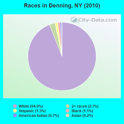
- 51894.0%White alone
- 152.7%Two or more races
- 71.3%Hispanic
- 61.1%Black alone
- 40.7%American Indian alone
- 10.2%Asian alone
Races in Denning detailed stats: ancestries, foreign born residents, place of birth
 Recent articles from our blog. Our writers, many of them Ph.D. graduates or candidates, create easy-to-read articles on a wide variety of topics.

 | Long Islanders Who Once Lived In New Mexico (25 replies) |
| Aircraft Noise over Nassau County (1563 replies) |
| Top 10 States People Are Fleeing...Guess who's #1? (253 replies) |
| Work in Rock Hill, live in - ?? (5 replies) |
| Upstate NY summer home (6 replies) |
| Catskills -- problems to avoid? (28 replies) |
Latest news from Denning, NY collected exclusively by city-data.com from local newspapers, TV, and radio stations
Ancestries: German (24.0%), Irish (23.3%), English (19.6%), Italian (13.6%), Polish (10.1%), Dutch (5.4%).
Current Local Time: EST time zone
Elevation: 1940 feet
Land area: 105.2 square miles.
Population density: 5.2 people per square mile (very low).
9 residents are foreign born
| This town: | 1.7% |
| New York: | 20.4% |
| Denning town: | 1.5% ($1,327) |
| New York: | 1.9% ($2,847) |
Nearest city with pop. 50,000+: Ramapo, NY  (60.7 miles , pop. 108,905).
Nearest city with pop. 200,000+: Bronx, NY (82.4 miles , pop. 1,332,650).
Nearest cities:
), ), ), ), ), ), Latitude: 41.95 N, Longitude: 74.49 W
Area code commonly used in this area: 845

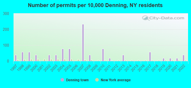
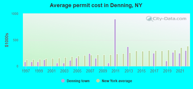
Single-family new house construction building permits:
- 2022: 2 buildings, average cost: $298,700
- 2021: 1 building, cost: $250,000
- 2020: 1 building, cost: $265,300
- 2019: 1 building, cost: $100,000
- 2017: 3 buildings, average cost: $250,000
- 2013: 2 buildings, average cost: $375,000
- 2011: 1 building, cost: $900,000
- 2010: 4 buildings, average cost: $62,500
- 2008: 2 buildings, average cost: $150,000
- 2007: 12 buildings, average cost: $243,300
- 2005: 4 buildings, average cost: $160,500
- 2004: 4 buildings, average cost: $113,600
- 2003: 2 buildings, average cost: $63,300
- 2002: 2 buildings, average cost: $64,300
- 2000: 2 buildings, average cost: $124,000
- 1999: 3 buildings, average cost: $82,500
- 1998: 3 buildings, average cost: $82,500
- 1997: 2 buildings, average cost: $82,500
| Here: | 3.9% |
| New York: | 4.4% |
- Accommodation & food services (15.0%)
- Educational services (10.1%)
- Health care (8.5%)
- Construction (8.1%)
- Public administration (6.1%)
- Religious, grantmaking, civic, professional, similar organizations (5.3%)
- Metal & metal products (4.9%)
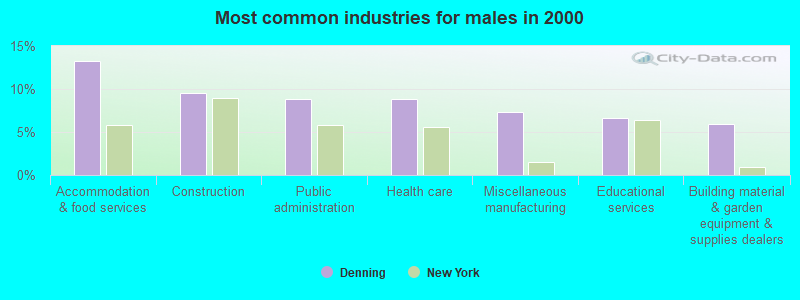
- Accommodation & food services (13.2%)
- Construction (9.6%)
- Public administration (8.8%)
- Health care (8.8%)
- Miscellaneous manufacturing (7.4%)
- Educational services (6.6%)
- Building material & garden equipment & supplies dealers (5.9%)
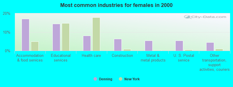
- Accommodation & food services (17.1%)
- Educational services (14.4%)
- Health care (8.1%)
- Construction (6.3%)
- Metal & metal products (5.4%)
- U. S. Postal service (5.4%)
- Other transportation, support activities, couriers (4.5%)
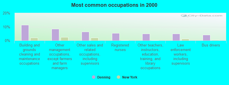
- Building and grounds cleaning and maintenance occupations (11.3%)
- Other management occupations, except farmers and farm managers (8.5%)
- Other sales and related occupations, including supervisors (6.5%)
- Registered nurses (5.3%)
- Other teachers, instructors, education, training, and library occupations (4.9%)
- Law enforcement workers, including supervisors (4.9%)
- Bus drivers (4.0%)
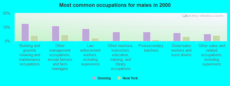
- Building and grounds cleaning and maintenance occupations (12.5%)
- Other management occupations, except farmers and farm managers (11.0%)
- Law enforcement workers, including supervisors (8.8%)
- Other teachers, instructors, education, training, and library occupations (6.6%)
- Postsecondary teachers (6.6%)
- Driver/sales workers and truck drivers (5.9%)
- Other sales and related occupations, including supervisors (5.1%)
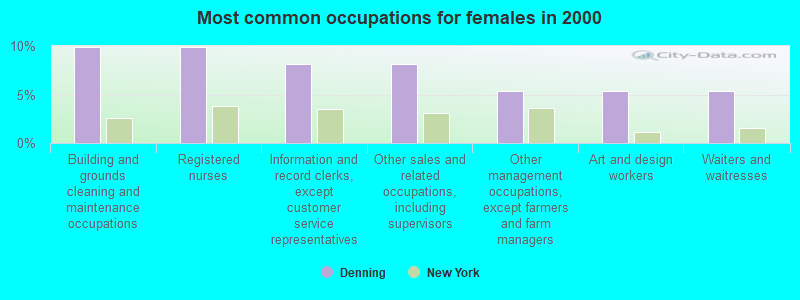
- Building and grounds cleaning and maintenance occupations (9.9%)
- Registered nurses (9.9%)
- Information and record clerks, except customer service representatives (8.1%)
- Other sales and related occupations, including supervisors (8.1%)
- Other management occupations, except farmers and farm managers (5.4%)
- Art and design workers (5.4%)
- Waiters and waitresses (5.4%)
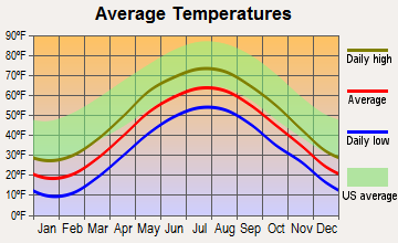
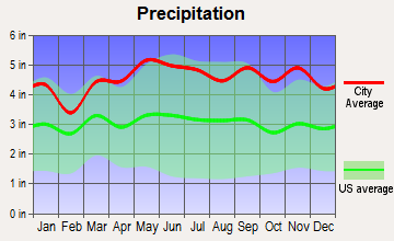
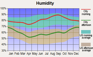
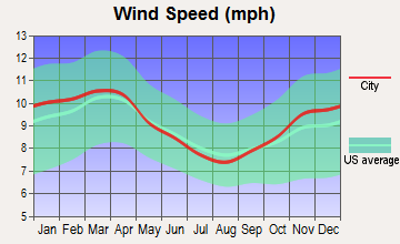
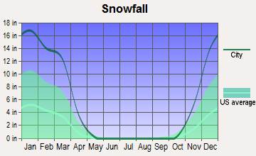
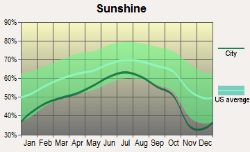
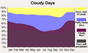
Average climate in Denning, New York
Based on data reported by over 4,000 weather stations
(lower is better)
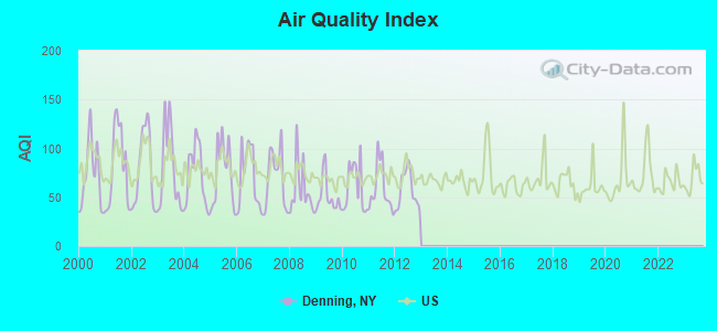
Air Quality Index (AQI) level in 2012 was 56.9. This is better than average.
| City: | 56.9 |
| U.S.: | 72.6 |
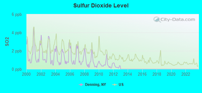
Sulfur Dioxide (SO2) [ppb] level in 2012 was 0.314. This is significantly better than average. Closest monitor was 13.7 miles away from the city center.
| City: | 0.314 |
| U.S.: | 1.515 |
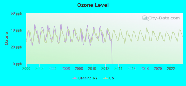
Ozone [ppb] level in 2012 was 32.5. This is about average. Closest monitor was 13.7 miles away from the city center.
| City: | 32.5 |
| U.S.: | 33.3 |
Tornado activity:
Denning-area historical tornado activity is slightly above New York state average. It is 46% smaller than the overall U.S. average.
On 7/10/1989, a category F4 (max. wind speeds 207-260 mph) tornado 38.1 miles away from the Denning town center injured 20 people and caused between $5,000,000 and $50,000,000 in damages.
On 5/31/1998, a category F3 (max. wind speeds 158-206 mph) tornado 27.9 miles away from the town center injured 12 people and caused $3 million in damages.
Earthquake activity:
Denning-area historical earthquake activity is significantly above New York state average. It is 67% smaller than the overall U.S. average.On 10/7/1983 at 10:18:46, a magnitude 5.3 (5.1 MB, 5.3 LG, 5.1 ML, Class: Moderate, Intensity: VI - VII) earthquake occurred 139.1 miles away from the city center
On 4/20/2002 at 10:50:47, a magnitude 5.3 (5.3 ML, Depth: 3.0 mi) earthquake occurred 182.0 miles away from the city center
On 4/20/2002 at 10:50:47, a magnitude 5.2 (5.2 MB, 4.2 MS, 5.2 MW, 5.0 MW) earthquake occurred 180.0 miles away from Denning center
On 8/23/2011 at 17:51:04, a magnitude 5.8 (5.8 MW, Depth: 3.7 mi) earthquake occurred 333.7 miles away from Denning center
On 1/16/1994 at 01:49:16, a magnitude 4.6 (4.6 MB, 4.6 LG, Depth: 3.1 mi, Class: Light, Intensity: IV - V) earthquake occurred 137.8 miles away from the city center
On 6/17/1991 at 08:53:16, a magnitude 4.1 (4.0 MB, 4.0 LG, Depth: 3.1 mi) earthquake occurred 48.3 miles away from the city center
Magnitude types: regional Lg-wave magnitude (LG), body-wave magnitude (MB), local magnitude (ML), surface-wave magnitude (MS), moment magnitude (MW)
Natural disasters:
The number of natural disasters in Ulster County (32) is a lot greater than the US average (15).Major Disasters (Presidential) Declared: 23
Emergencies Declared: 8
Causes of natural disasters: Floods: 12, Storms: 12, Hurricanes: 6, Snowstorms: 3, Blizzards: 2, Tropical Storms: 2, Power Outage: 1, Tornado: 1, Tropical Depression: 1, Water Shortage: 1, Wind: 1, Winter Storm: 1, Other: 3 (Note: some incidents may be assigned to more than one category).
Colleges/universities with over 2000 students nearest to Denning:
- Ulster County Community College (about 20 miles; Stone Ridge, NY; Full-time enrollment: 2,207)
- State University of New York at New Paltz (about 26 miles; New Paltz, NY; FT enrollment: 7,319)
- Bard College (about 31 miles; Annandale-On-Hudson, NY; FT enrollment: 3,137)
- SUNY College of Technology at Delhi (about 32 miles; Delhi, NY; FT enrollment: 2,911)
- Culinary Institute of America (about 32 miles; Hyde Park, NY; FT enrollment: 3,869)
- Marist College (about 33 miles; Poughkeepsie, NY; FT enrollment: 5,536)
- Dutchess Community College (about 34 miles; Poughkeepsie, NY; FT enrollment: 6,554)
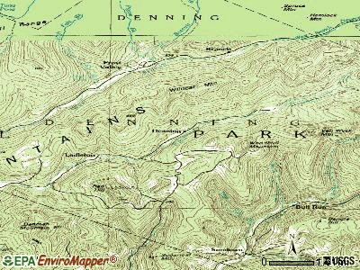
Points of interest:
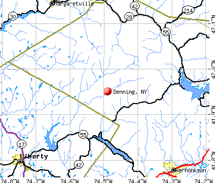
Notable locations in Denning: Camp Wawayanda (A), Claryville Fire Department (B). Display/hide their locations on the map
Lakes: Peekamoose Lake (A), Round Pond (B), Sand Pond (C). Display/hide their locations on the map
Streams, rivers, and creeks: Buttermilk Falls Brook (A), Tray Mill Brook (B), Clear Creek (C), Shelter Creek (D), East Moor Brook (E), Bear Hole Brook (F), Picket Brook (G), Pigeon Brook (H), Fall Brook (I). Display/hide their locations on the map
| This town: | 2.3 people |
| New York: | 2.6 people |
| This town: | 60.7% |
| Whole state: | 63.5% |
| This town: | 10.7% |
| Whole state: | 6.8% |
Likely homosexual households (counted as self-reported same-sex unmarried-partner households)
- Lesbian couples: 0.0% of all households
- Gay men: 1.3% of all households
| This town: | 12.0% |
| Whole state: | 14.6% |
| This town: | 4.1% |
| Whole state: | 7.4% |
33 people in other nonhousehold living situations in 2000
For population 15 years and over in Denning:
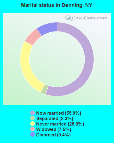
- Never married: 25.8%
- Now married: 55.0%
- Separated: 2.3%
- Widowed: 7.5%
- Divorced: 9.4%
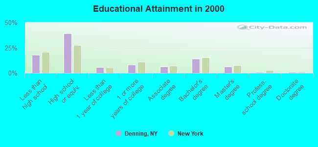
For population 25 years and over in Denning:
- High school or higher: 81.8%
- Bachelor's degree or higher: 22.3%
- Graduate or professional degree: 8.4%
- Unemployed: 2.8%
- Mean travel time to work (commute): 37.7 minutes
| Here: | 11.8 |
| New York average: | 14.2 |
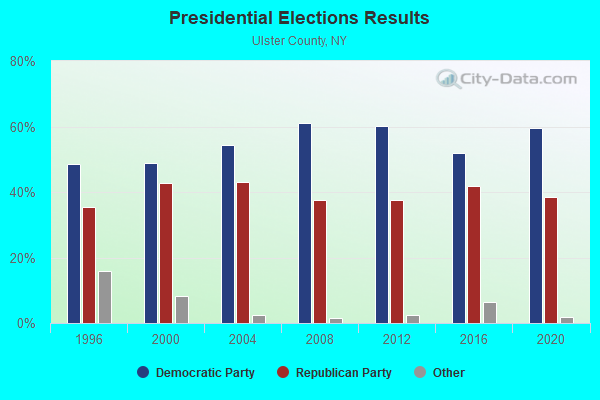
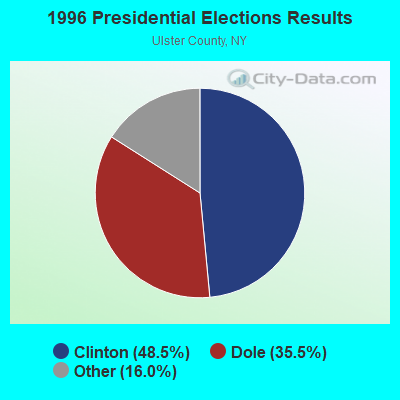
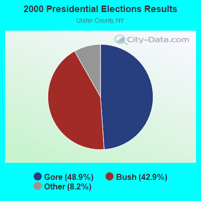
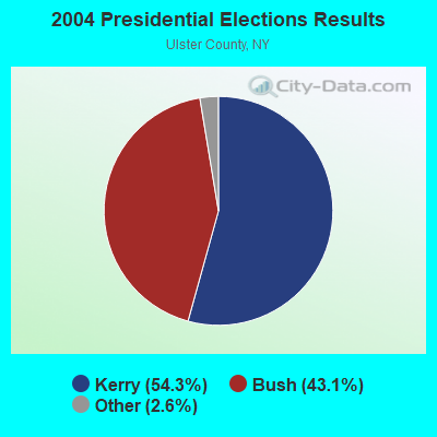
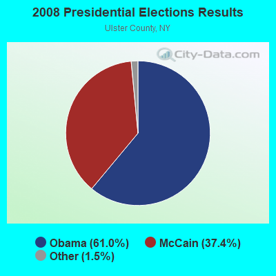

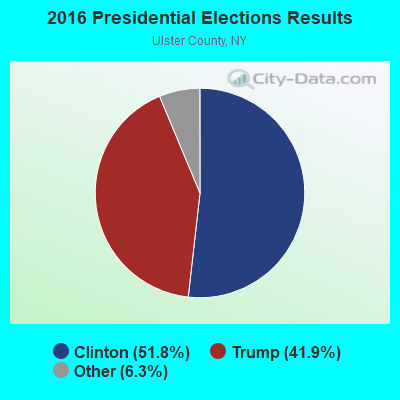
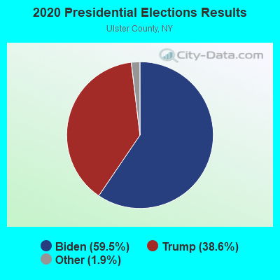
Graphs represent county-level data. Detailed 2008 Election Results
Religion statistics for Denning, NY (based on Ulster County data)
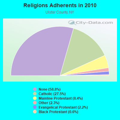
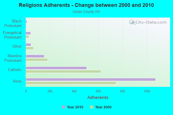
| Religion | Adherents | Congregations |
|---|---|---|
| Catholic | 50,256 | 27 |
| Mainline Protestant | 15,311 | 78 |
| Other | 4,262 | 30 |
| Evangelical Protestant | 4,104 | 42 |
| Black Protestant | 1,064 | 7 |
| Orthodox | 150 | 1 |
| None | 107,346 | - |
Food Environment Statistics:
| Ulster County: | 2.48 / 10,000 pop. |
| New York: | 4.13 / 10,000 pop. |
| This county: | 0.11 / 10,000 pop. |
| New York: | 0.06 / 10,000 pop. |
| Ulster County: | 1.27 / 10,000 pop. |
| State: | 0.92 / 10,000 pop. |
| This county: | 3.91 / 10,000 pop. |
| New York: | 1.68 / 10,000 pop. |
| Ulster County: | 12.61 / 10,000 pop. |
| New York: | 8.82 / 10,000 pop. |
| Here: | 8.1% |
| New York: | 8.2% |
| This county: | 26.7% |
| New York: | 23.8% |
| This county: | 18.9% |
| State: | 15.6% |
Strongest AM radio stations in Denning:
- WELV (1370 AM; daytime; 5 kW; ELLENVILLE, NY; Owner: CLEAR CHANNEL BROADCASTING LICENSES, INC.)
- WGY (810 AM; 50 kW; SCHENECTADY, NY; Owner: CLEAR CHANNEL BROADCASTING LICENSES, INC.)
- WMCA (570 AM; 50 kW; NEW YORK, NY; Owner: SALEM MEDIA OF NEW YORK, LLC)
- WABC (770 AM; 50 kW; NEW YORK, NY; Owner: WABC-AM RADIO, INC.)
- WFAN (660 AM; 50 kW; NEW YORK, NY; Owner: INFINITY BROADCASTING OPERATIONS, INC.)
- WOR (710 AM; 50 kW; NEW YORK, NY; Owner: BUCKLEY BROADCASTING CORPORATION)
- WNNZ (640 AM; 50 kW; WESTFIELD, MA; Owner: CLEAR CHANNEL BROADCASTING LICENSES, INC.)
- WPTR (1540 AM; 50 kW; ALBANY, NY; Owner: KIMTRON, INC.)
- WCBS (880 AM; 50 kW; NEW YORK, NY; Owner: INFINITY BROADCASTING OPERATIONS, INC.)
- WINS (1010 AM; 50 kW; NEW YORK, NY; Owner: INFINITY BROADCASTING OPERATIONS, INC.)
- WGHQ (920 AM; 5 kW; KINGSTON, NY; Owner: CLEVELAND RADIO LICENSES, LLC)
- WEPN (1050 AM; 50 kW; NEW YORK, NY; Owner: NEW YORK AM RADIO, LLC)
- WGNY (1220 AM; 10 kW; NEWBURGH, NY; Owner: SUNRISE BROADCASTING LLC)
Strongest FM radio stations in Denning:
- WFKP (99.3 FM; ELLENVILLE, NY; Owner: CLEAR CHANNEL BROADCASTING LICENSES, INC.)
- WAMK (90.9 FM; KINGSTON, NY; Owner: W A M C)
- WFGB (89.7 FM; KINGSTON, NY; Owner: SOUND OF LIFE, INC.)
- WPDH (101.5 FM; POUGHKEEPSIE, NY; Owner: CUMULUS LICENSING CORP.)
- WPDA (106.1 FM; JEFFERSONVILLE, NY; Owner: CUMULUS LICENSING CORP.)
- WFNP (88.7 FM; ROSENDALE, NY; Owner: STATE UNIVERSITY OF NEW YORK)
- WRHV (88.7 FM; POUGHKEEPSIE, NY; Owner: WMHT EDUCATIONAL TELECOMMUNICATIONS)
- WRIP (97.9 FM; WINDHAM, NY; Owner: RIP RADIO, LLC)
- WJFF (90.5 FM; JEFFERSONVILLE, NY; Owner: RADIO CATSKILL)
- WGKR (105.3 FM; GRAND GORGE, NY; Owner: SOUND OF LIFE, INC.)
- WGWR (88.1 FM; LIBERTY, NY; Owner: SOUND OF LIFE, INC.)
- WCZX (97.7 FM; HYDE PARK, NY; Owner: CUMULUS LICENSING CORP.)
- WRRB (96.9 FM; ARLINGTON, NY; Owner: CUMULUS LICENSING CORP.)
- WZAD (97.3 FM; WURTSBORO, NY; Owner: CUMULUS LICENSING CORP.)
- WBWZ (93.3 FM; NEW PALTZ, NY; Owner: CLEVELAND RADIO LICENSES, LLC)
- WRWD-FM (107.3 FM; HIGHLAND, NY; Owner: CLEVELAND RADIO LICENSES, LLC)
- WOSR (91.7 FM; MIDDLETOWN, NY; Owner: WAMC)
- WSUL (98.3 FM; MONTICELLO, NY; Owner: REYNOLDS COMMUNICATIONS, INC.)
- WSPK (104.7 FM; POUGHKEEPSIE, NY; Owner: 6 JOHNSON ROAD LICENSES, INC.)
- W292CM (106.3 FM; POUGHKEEPSIE, NY; Owner: JOHN KATONAH)
TV broadcast stations around Denning:
- W30AZ (Channel 30; LIBERTY, NY; Owner: JOHN MESTER INCOME FAMILY TRUST)
- National Bridge Inventory (NBI) Statistics
- 21Number of bridges
- 128ft / 39.4mTotal length
- $29,047,000Total costs
- 3,475Total average daily traffic
- 227Total average daily truck traffic
- 4,865Total future (year 2033) average daily traffic
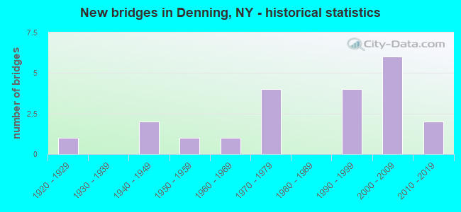
- New bridges - historical statistics
- 11920-1929
- 21940-1949
- 11950-1959
- 11960-1969
- 41970-1979
- 41990-1999
- 62000-2009
- 22010-2019
FCC Registered Broadcast Land Mobile Towers:
3- ID_8508, County Route 42 (Lat: 41.953333 Lon: -74.398333), Type: Tower, Structure height: 30.5 m, Call Sign: WQGC862,
Assigned Frequencies: 854.962 MHz, 856.987 MHz, Grant Date: 12/12/2006, Expiration Date: 12/12/2016, Cancellation Date: 01/03/2011, Certifier: Thomas J Cowper, Registrant: Nys Dhses Office Of Interoperable And Emergency Communications, State Office Campus Building 22, 1220 Washington Ave, Albany, NY 12226, Phone: (518) 322-4912, Fax: (518) 322-4975, Email:
- CSULS-16, County Route 46 (Lat: 41.885000 Lon: -74.431667), Type: Upole, Structure height: 18.3 m, Call Sign: WQHK425,
Assigned Frequencies: 855.237 MHz, 855.462 MHz, 855.712 MHz, 855.737 MHz, 856.212 MHz, 856.262 MHz, 856.437 MHz, 856.737 MHz, 856.937 MHz, 856.987 MHz... (+11 more), Grant Date: 08/21/2007, Expiration Date: 08/21/2017, Cancellation Date: 01/03/2011, Registrant: Nys Dhses Office Of Interoperable And Emergency Communications, State Office Campus Building 22, 1220 Washington Ave, Albany, NY 12226, Phone: (518) 322-4912, Fax: (518) 322-4975, Email:
- Ulster Cell Site 9, 2390 Denning Road (Lat: 41.938333 Lon: -74.505000), Type: Tower, Structure height: 18.3 m, Call Sign: WQHL618,
Assigned Frequencies: 855.237 MHz, 855.462 MHz, 855.712 MHz, 855.737 MHz, 856.212 MHz, 856.262 MHz, 856.437 MHz, 856.737 MHz, 856.937 MHz, 856.987 MHz... (+14 more), Grant Date: 08/31/2007, Expiration Date: 08/31/2017, Cancellation Date: 01/03/2011, Certifier: Thomas J Cowper, Registrant: Nys Dhses Office Of Interoperable And Emergency Communications, State Office Campus Building 22, 1220 Washington Ave, Albany, NY 12226, Phone: (518) 322-4912, Fax: (518) 322-4975, Email:
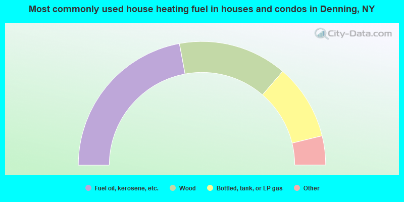
- 44.2%Fuel oil, kerosene, etc.
- 28.5%Wood
- 19.8%Bottled, tank, or LP gas
- 2.3%Electricity
- 1.7%Other fuel
- 1.2%Utility gas
- 1.2%Coal or coke
- 1.2%No fuel used
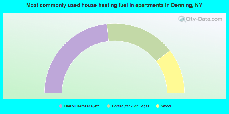
- 46.5%Fuel oil, kerosene, etc.
- 32.6%Bottled, tank, or LP gas
- 20.9%Wood
Denning compared to New York state average:
- Median house value below state average.
- Unemployed percentage significantly below state average.
- Black race population percentage significantly below state average.
- Hispanic race population percentage significantly below state average.
- Median age above state average.
- Foreign-born population percentage significantly below state average.
- Renting percentage below state average.
- Length of stay since moving in significantly above state average.
- Number of rooms per house significantly below state average.
- House age significantly below state average.