Decatur, New York
Submit your own pictures of this town and show them to the world
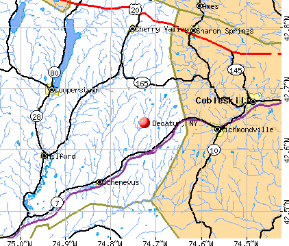
- OSM Map
- General Map
- Google Map
- MSN Map
Population change since 2000: -13.9%
 |
| Males: 181 | |
| Females: 172 |
| Median resident age: | 51.2 years |
| New York median age: | 40.7 years |
Zip codes: 12197.
| Decatur: | $57,478 |
| NY: | $79,557 |
Estimated per capita income in 2022: $34,207 (it was $16,541 in 2000)
Decatur town income, earnings, and wages data
Estimated median house or condo value in 2022: $192,929 (it was $82,700 in 2000)
| Decatur: | $192,929 |
| NY: | $400,400 |
Mean prices in 2022: all housing units: $228,779; detached houses: $247,959; townhouses or other attached units: $313,844; in 2-unit structures: $212,590; in 3-to-4-unit structures: $357,277; in 5-or-more-unit structures: $928,498; mobile homes: $87,717
Detailed information about poverty and poor residents in Decatur, NY
Compare current foreclosures near Decatur, NY:
| Photo | Address | Area | Beds / Baths | Price | Details |
|---|---|---|---|---|---|

|
#1
Skinner Hill Rd
Worcester, NY 12197
|
- sq. feet
|
1 baths 3 beds |
$134,900
|
show details |

|
#2
Axtell Rd
Maryland, NY 12116
|
2,238 sq. feet
|
2 baths 4 beds |
$94,900
|
show details |

|
#3
Valder Rd
Schenevus, NY 12155
|
2,736 sq. feet
|
1 baths 4 beds |
$29,900
|
show details |

|
#4
Main St
East Worcester, NY 12064
|
1,300 sq. feet
|
1 baths 3 beds |
show details | |

|
#5
County Highway 29a
Springfield Center, NY 13468
|
- sq. feet
|
2 baths 4 beds |
show details | |

|
#6
Latimer Hill Rd
Canajoharie, NY 13317
|
1,890 sq. feet
|
2 baths 4 beds |
show details | |

|
#7
Mcguire Rd
Sprakers, NY 12166
|
2,093 sq. feet
|
1 baths 3 beds |
show details | |

|
#8
County Highway 29
Davenport, NY 13750
|
768 sq. feet
|
1 baths 2 beds |
show details | |

|
#9
Caverns Rd
Howes Cave, NY 12092
|
1,692 sq. feet
|
2 baths 4 beds |
show details | |

|
#10
Caverns Rd
Howes Cave, NY 12092
|
1,148 sq. feet
|
1 baths 3 beds |
show details |
| Photo | Address | Area | Beds / Baths | Price | Details |
|---|---|---|---|---|---|

|
#11
Snyder Rd
Cobleskill, NY 12043
|
2,140 sq. feet
|
1 baths 3 beds |
show details | |

|
#12
Evergreen Rd
Cobleskill, NY 12043
|
1,164 sq. feet
|
1 baths 3 beds |
show details | |

|
#13
Trolley Line Rd
Cooperstown, NY 13326
|
2,259 sq. feet
|
2 baths 3 beds |
show details | |

|
#14
Evergreen Rd
Cobleskill, NY 12043
|
1,708 sq. feet
|
1 baths 3 beds |
show details | |

|
#15
Us Highway 20
East Springfield, NY 13333
|
1,144 sq. feet
|
2 baths 3 beds |
show details | |

|
#16
North St
Cobleskill, NY 12043
|
1,894 sq. feet
|
2 baths 4 beds |
show details | |

|
#17
Prospect St
Cobleskill, NY 12043
|
2,235 sq. feet
|
2 baths 4 beds |
show details | |

|
#18
State Route 145
Sharon Springs, NY 13459
|
1,512 sq. feet
|
2 baths 3 beds |
show details | |

|
#19
W Richmondville Rd
Cobleskill, NY 12043
|
1,125 sq. feet
|
1 baths 3 beds |
show details | |

|
#20
Winegard Rd
Richmondville, NY 12149
|
961 sq. feet
|
2 baths 2 beds |
show details |
| Photo | Address | Area | Beds / Baths | Price | Details |
|---|---|---|---|---|---|

|
#21
Chestnut St
Sharon Springs, NY 13459
|
1,843 sq. feet
|
1 baths 3 beds |
show details | |

|
#22
Sawyer Hollow Rd
Richmondville, NY 12149
|
- sq. feet
|
- baths - beds |
show details | |

|
#23
Main St Apt A
Cooperstown, NY 13326
|
- sq. feet
|
- baths - beds |
show details | |

|
#24
Hite Rd
Warnerville, NY 12187
|
- sq. feet
|
- baths - beds |
show details | |

|
#25
Highway Route 20
Sharon Springs, NY 13459
|
- sq. feet
|
- baths - beds |
show details | |

|
#26
County Highway 33
Cherry Valley, NY 13320
|
- sq. feet
|
- baths - beds |
show details | |

|
#27
Union St Apt 2
Cobleskill, NY 12043
|
- sq. feet
|
- baths - beds |
show details | |

|
#28
White House Xing
Worcester, NY 12197
|
- sq. feet
|
- baths - beds |
show details | |

|
#29
Engleville Rd
Sharon Springs, NY 13459
|
- sq. feet
|
- baths - beds |
show details | |

|
#30
Kings Ln
Cobleskill, NY 12043
|
- sq. feet
|
- baths - beds |
show details |
| Photo | Address | Area | Beds / Baths | Price | Details |
|---|---|---|---|---|---|

|
#31
County Highway 33
Cooperstown, NY 13326
|
- sq. feet
|
- baths - beds |
show details | |

|
#32
Harder Ave Apt 1
Cobleskill, NY 12043
|
- sq. feet
|
- baths - beds |
show details | |

|
#33
Vanderwerken Rd
Sloansville, NY 12160
|
- sq. feet
|
- baths - beds |
show details | |

|
#34
County Highway 37
Worcester, NY 12197
|
- sq. feet
|
- baths - beds |
show details | |

|
#35
Ecker Hollow Rd
Schoharie, NY 12157
|
- sq. feet
|
- baths - beds |
show details | |

|
#36
Brighton Rd
Worcester, NY 12197
|
- sq. feet
|
- baths - beds |
show details | |

|
Check over 1 million property listings on Foreclosure.com!
|
browse all offers | |||

- 34096.3%White alone
- 51.4%Hispanic
- 41.1%Two or more races
- 30.8%Black alone
- 10.3%Asian alone
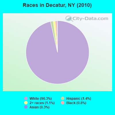
Races in Decatur detailed stats: ancestries, foreign born residents, place of birth
According to our research of New York and other state lists, there were 2 registered sex offenders living in Decatur, New York as of May 18, 2024.
The ratio of all residents to sex offenders in Decatur is 177 to 1.
 Recent articles from our blog. Our writers, many of them Ph.D. graduates or candidates, create easy-to-read articles on a wide variety of topics.

 | gun buying on long island (46 replies) |
| Syracuse, NY Population Rankings Using Different Definitions (20 replies) |
| ghettos or hoods? (171 replies) |
| Talk to me about Riverdale? (77 replies) |
| Buying a Co-op on Bronx Park East, Pelham Parkway (45 replies) |
| St. James Park (Bronx), late 1960s (102 replies) |
Latest news from Decatur, NY collected exclusively by city-data.com from local newspapers, TV, and radio stations
Ancestries: German (18.5%), Irish (9.8%), English (9.5%), United States (9.5%), Italian (7.1%), French (6.1%).
Current Local Time: EST time zone
Elevation: 1600 feet
Land area: 20.6 square miles.
Population density: 17 people per square mile (very low).
15 residents are foreign born (3.2% Europe, 0.5% North America).
| This town: | 3.7% |
| New York: | 20.4% |
| Decatur town: | 1.3% ($1,114) |
| New York: | 1.9% ($2,847) |
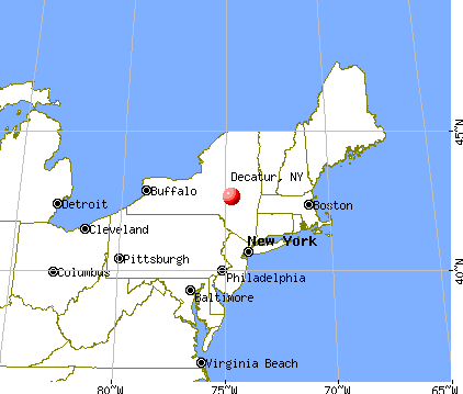
Nearest city with pop. 50,000+: Utica, NY  (39.9 miles , pop. 60,651).
Nearest city with pop. 200,000+: Bronx, NY (133.2 miles , pop. 1,332,650).
Nearest cities:
), ), ), ), )Latitude: 42.67 N, Longitude: 74.70 W

| Here: | 4.7% |
| New York: | 4.4% |
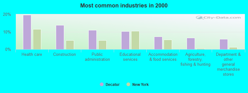
- Health care (19.7%)
- Construction (13.9%)
- Public administration (10.9%)
- Educational services (10.2%)
- Accommodation & food services (7.3%)
- Agriculture, forestry, fishing & hunting (6.6%)
- Department & other general merchandise stores (5.8%)
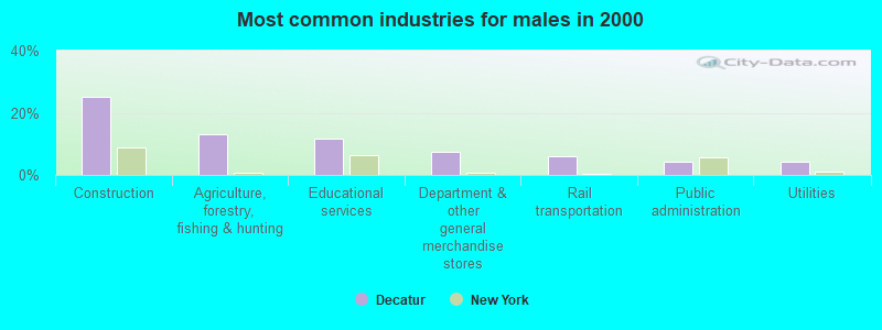
- Construction (25.0%)
- Agriculture, forestry, fishing & hunting (13.2%)
- Educational services (11.8%)
- Department & other general merchandise stores (7.4%)
- Rail transportation (5.9%)
- Public administration (4.4%)
- Utilities (4.4%)
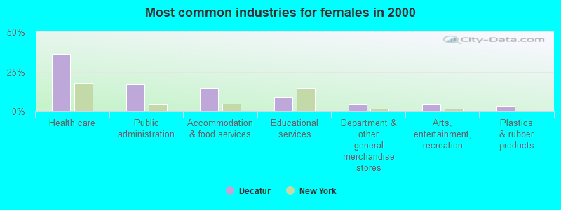
- Health care (36.2%)
- Public administration (17.4%)
- Accommodation & food services (14.5%)
- Educational services (8.7%)
- Department & other general merchandise stores (4.3%)
- Arts, entertainment, recreation (4.3%)
- Plastics & rubber products (2.9%)
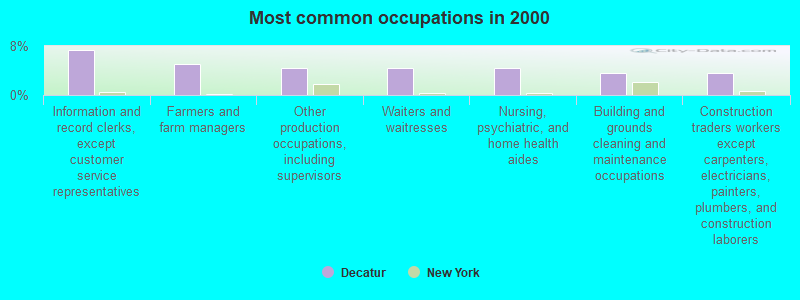
- Information and record clerks, except customer service representatives (7.3%)
- Farmers and farm managers (5.1%)
- Other production occupations, including supervisors (4.4%)
- Waiters and waitresses (4.4%)
- Nursing, psychiatric, and home health aides (4.4%)
- Building and grounds cleaning and maintenance occupations (3.6%)
- Construction traders workers except carpenters, electricians, painters, plumbers, and construction laborers (3.6%)
- Farmers and farm managers (10.3%)
- Other production occupations, including supervisors (8.8%)
- Construction traders workers except carpenters, electricians, painters, plumbers, and construction laborers (7.4%)
- Retail sales workers, except cashiers (5.9%)
- Vehicle and mobile equipment mechanics, installers, and repairers (5.9%)
- Electrical equipment mechanics and other installation, maintenance, and repair workers, including supervisors (5.9%)
- Rail and water transportation workers (5.9%)
- Information and record clerks, except customer service representatives (10.1%)
- Waiters and waitresses (8.7%)
- Nursing, psychiatric, and home health aides (8.7%)
- Building and grounds cleaning and maintenance occupations (7.2%)
- Registered nurses (5.8%)
- Cashiers (4.3%)
- Other health diagnosing and treating practitioners and technical occupations (2.9%)
Average climate in Decatur, New York
Based on data reported by over 4,000 weather stations


Tornado activity:
Decatur-area historical tornado activity is near New York state average. It is 63% smaller than the overall U.S. average.
On 7/10/1989, a category F4 (max. wind speeds 207-260 mph) tornado 14.1 miles away from the Decatur town center injured 20 people and caused between $5,000,000 and $50,000,000 in damages.
On 5/31/1998, a category F3 (max. wind speeds 158-206 mph) tornado 13.2 miles away from the town center injured 3 people and caused $800,000 in damages.
Earthquake activity:
Decatur-area historical earthquake activity is significantly above New York state average. It is 67% smaller than the overall U.S. average.On 10/7/1983 at 10:18:46, a magnitude 5.3 (5.1 MB, 5.3 LG, 5.1 ML, Class: Moderate, Intensity: VI - VII) earthquake occurred 90.5 miles away from the city center
On 4/20/2002 at 10:50:47, a magnitude 5.3 (5.3 ML, Depth: 3.0 mi) earthquake occurred 137.0 miles away from the city center
On 4/20/2002 at 10:50:47, a magnitude 5.2 (5.2 MB, 4.2 MS, 5.2 MW, 5.0 MW) earthquake occurred 135.0 miles away from the city center
On 6/17/1991 at 08:53:16, a magnitude 4.1 (4.0 MB, 4.0 LG, Depth: 3.1 mi, Class: Light, Intensity: IV - V) earthquake occurred 3.0 miles away from the city center
On 8/23/2011 at 17:51:04, a magnitude 5.8 (5.8 MW, Depth: 3.7 mi) earthquake occurred 370.8 miles away from Decatur center
On 1/19/1982 at 00:14:42, a magnitude 4.7 (4.5 MB, 4.7 MD, 4.5 LG) earthquake occurred 166.8 miles away from the city center
Magnitude types: regional Lg-wave magnitude (LG), body-wave magnitude (MB), duration magnitude (MD), local magnitude (ML), surface-wave magnitude (MS), moment magnitude (MW)
Natural disasters:
The number of natural disasters in Otsego County (22) is greater than the US average (15).Major Disasters (Presidential) Declared: 13
Emergencies Declared: 7
Causes of natural disasters: Storms: 10, Floods: 8, Hurricanes: 3, Snowstorms: 2, Tropical Storms: 2, Blizzard: 1, Ice Storm: 1, Power Outage: 1, Tornado: 1, Wind: 1, Winter Storm: 1, Other: 2 (Note: some incidents may be assigned to more than one category).

Hospitals and medical centers near Decatur:
- COBLESKILL REGIONAL HOSPITAL Acute Care Hospitals (about 11 miles away; COBLESKILL, NY)
- EDEN PARK HEALTH CARE CENTRE INC COBLESKILL (Nursing Home, about 12 miles away; COBLESKILL, NY)
- MARY IMOGENE BASSETT HOSPITAL (Dialysis Facility, about 12 miles away; COOPERSTOWN, NY)
- OTSEGO MANOR (Nursing Home, about 13 miles away; COOPERSTOWN, NY)
Colleges/universities with over 2000 students nearest to Decatur:
- SUNY College of Agriculture and Technology at Cobleskill (about 11 miles; Cobleskill, NY; Full-time enrollment: 2,455)
- SUNY Oneonta (about 24 miles; Oneonta, NY; FT enrollment: 6,081)
- Herkimer County Community College (about 30 miles; Herkimer, NY; FT enrollment: 2,774)
- Fulton-Montgomery Community College (about 30 miles; Johnstown, NY; FT enrollment: 2,043)
- SUNY College of Technology at Delhi (about 30 miles; Delhi, NY; FT enrollment: 2,911)
- Mohawk Valley Community College (about 39 miles; Utica, NY; FT enrollment: 5,693)
- Schenectady County Community College (about 40 miles; Schenectady, NY; FT enrollment: 3,676)
Points of interest:
Cemeteries: Ferris Cemetery (1), Decatur Cemetery (2). Display/hide their locations on the map
Lake: Bear Swamp Pond (A). Display/hide its location on the map
| This town: | 2.3 people |
| New York: | 2.6 people |
| This town: | 73.0% |
| Whole state: | 63.5% |
| This town: | 4.6% |
| Whole state: | 6.8% |
No gay or lesbian households reported
| This town: | 4.4% |
| Whole state: | 14.6% |
| This town: | 0.5% |
| Whole state: | 7.4% |
For population 15 years and over in Decatur:
- Never married: 17.1%
- Now married: 66.3%
- Separated: 1.0%
- Widowed: 7.9%
- Divorced: 7.6%
For population 25 years and over in Decatur:
- High school or higher: 73.6%
- Bachelor's degree or higher: 12.5%
- Graduate or professional degree: 3.6%
- Unemployed: 14.4%
- Mean travel time to work (commute): 37.8 minutes
| Here: | 9.3 |
| New York average: | 14.2 |
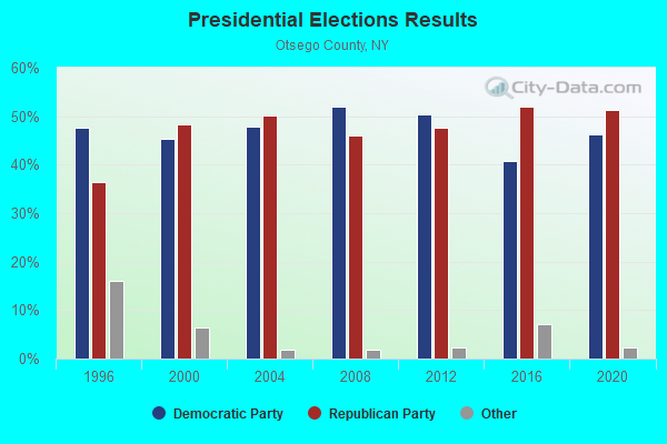
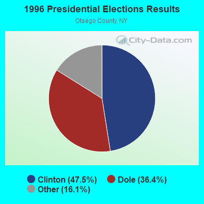
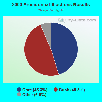
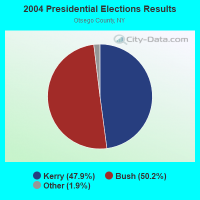
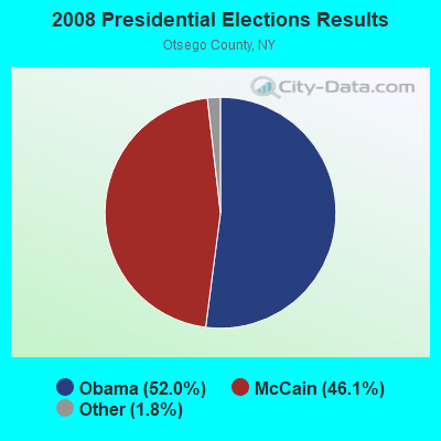
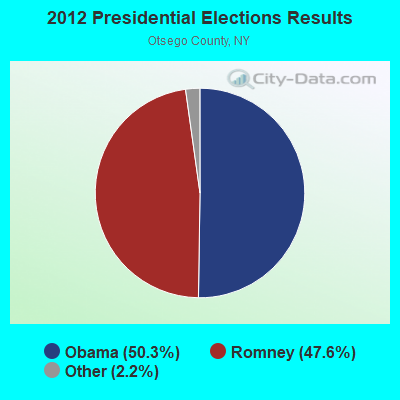
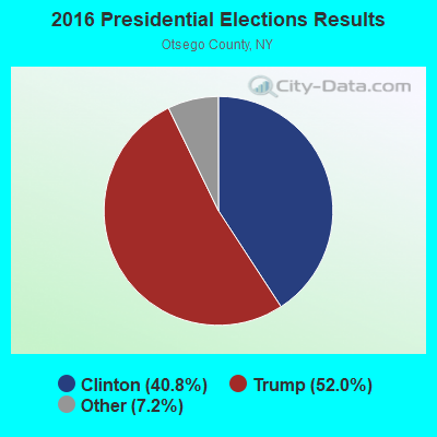
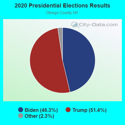
Graphs represent county-level data. Detailed 2008 Election Results
Religion statistics for Decatur, NY (based on Otsego County data)
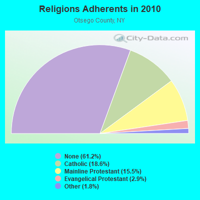
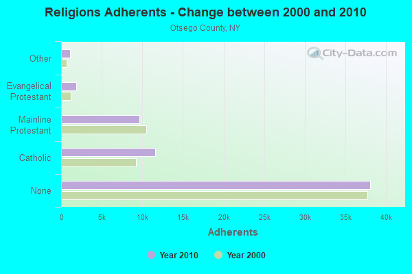
| Religion | Adherents | Congregations |
|---|---|---|
| Catholic | 11,599 | 6 |
| Mainline Protestant | 9,637 | 69 |
| Evangelical Protestant | 1,829 | 26 |
| Other | 1,094 | 9 |
| Orthodox | 25 | 1 |
| None | 38,075 | - |
Food Environment Statistics:
| This county: | 2.89 / 10,000 pop. |
| State: | 4.13 / 10,000 pop. |
| Otsego County: | 0.32 / 10,000 pop. |
| New York: | 0.06 / 10,000 pop. |
| This county: | 0.96 / 10,000 pop. |
| New York: | 0.92 / 10,000 pop. |
| Otsego County: | 5.62 / 10,000 pop. |
| New York: | 1.68 / 10,000 pop. |
| This county: | 9.96 / 10,000 pop. |
| New York: | 8.82 / 10,000 pop. |
| Otsego County: | 7.7% |
| State: | 8.2% |
| Here: | 24.6% |
| State: | 23.8% |
| Here: | 15.6% |
| New York: | 15.6% |
Strongest AM radio stations in Decatur:
- WGY (810 AM; 50 kW; SCHENECTADY, NY; Owner: CLEAR CHANNEL BROADCASTING LICENSES, INC.)
- WPTR (1540 AM; 50 kW; ALBANY, NY; Owner: KIMTRON, INC.)
- WNNZ (640 AM; 50 kW; WESTFIELD, MA; Owner: CLEAR CHANNEL BROADCASTING LICENSES, INC.)
- WXBH (1190 AM; 1 kW; COBLESKILL, NY; Owner: NY COMMUNICATIONS, LLC)
- WMCA (570 AM; 50 kW; NEW YORK, NY; Owner: SALEM MEDIA OF NEW YORK, LLC)
- WFAN (660 AM; 50 kW; NEW YORK, NY; Owner: INFINITY BROADCASTING OPERATIONS, INC.)
- WABC (770 AM; 50 kW; NEW YORK, NY; Owner: WABC-AM RADIO, INC.)
- WOR (710 AM; 50 kW; NEW YORK, NY; Owner: BUCKLEY BROADCASTING CORPORATION)
- WROW (590 AM; 5 kW; ALBANY, NY; Owner: 6 JOHNSON ROAD LICENSES, INC.)
- WTIC (1080 AM; 50 kW; HARTFORD, CT; Owner: INFINITY RADIO OPERATIONS INC.)
- WCBS (880 AM; 50 kW; NEW YORK, NY; Owner: INFINITY BROADCASTING OPERATIONS, INC.)
- WDOS (730 AM; 1 kW; ONEONTA, NY; Owner: ULTIMATE B/CASTING NETWORK, INC.)
- WWJZ (640 AM; 50 kW; MOUNT HOLLY, NJ; Owner: ABC, INC.)
Strongest FM radio stations in Decatur:
- WJIV (101.9 FM; CHERRY VALLEY, NY; Owner: CHRISTIAN BROADCASTING SYSTEM, LTD.)
- WGKR (105.3 FM; GRAND GORGE, NY; Owner: SOUND OF LIFE, INC.)
- WBUG-FM (101.1 FM; FORT PLAIN, NY; Owner: ROSER COMMUNICATIONS NETWORK, INC.)
- WMYY (97.3 FM; SCHOHARIE, NY; Owner: CAPITAL MEDIA CORPORATION)
- WDHI (100.3 FM; DELHI, NY; Owner: BANJO COMMUNICATIONS GROUP, INC.)
- WAJZ (96.3 FM; VOORHEESVILLE, NY; Owner: 6 JOHNSON ROAD LICENSES, INC.)
- WRIP (97.9 FM; WINDHAM, NY; Owner: RIP RADIO, LLC)
- WZMR (104.9 FM; ALTAMONT, NY; Owner: 6 JOHNSON ROAD LICENSES, INC.)
- WYJB (95.5 FM; ALBANY, NY; Owner: 6 JOHNSON ROAD LICENSES, INC.)
- WGNA-FM (107.7 FM; ALBANY, NY; Owner: REGENT LICENSEE OF MANSFIELD, INC.)
- WAMK (90.9 FM; KINGSTON, NY; Owner: W A M C)
- WMHT-FM (89.1 FM; SCHENECTADY, NY; Owner: WMHT EDUCATIONAL TELECOMMUNICATIONS)
- WFGB (89.7 FM; KINGSTON, NY; Owner: SOUND OF LIFE, INC.)
- WRVE (99.5 FM; SCHENECTADY, NY; Owner: CLEAR CHANNEL BROADCASTING LICENSES, INC.)
- WPYX (106.5 FM; ALBANY, NY; Owner: CAPSTAR TX LIMITED PARTNERSHIP)
- WSQC-FM (91.7 FM; ONEONTA, NY; Owner: WSKG PUBLIC TELECOMM. COUNCIL)
- WQBJ (103.5 FM; COBLESKILL, NY; Owner: REGENT LICENSEE OF MANSFIELD, INC.)
- WSRK (103.9 FM; ONEONTA, NY; Owner: ULTIMATE B/CASTING NETWORK, INC.)
- WVCR-FM (88.3 FM; LOUDONVILLE, NY; Owner: SIENA COLLEGE)
- WFLY (92.3 FM; TROY, NY; Owner: 6 JOHNSON ROAD LICENSES, INC.)
TV broadcast stations around Decatur:
- WKTV (Channel 2; UTICA, NY; Owner: SMITH TELEVISION OF NEW YORK LICENSE HOLDINGS, INC.)
- WYPX (Channel 55; AMSTERDAM, NY; Owner: PAXSON ALBANY LICENSE, INC.)
- National Bridge Inventory (NBI) Statistics
- 2Number of bridges
- 10ft / 3.2mTotal length
- $1,217,000Total costs
- 304Total average daily traffic
- 15Total average daily truck traffic
- 426Total future (year 2037) average daily traffic
Decatur compared to New York state average:
- Median house value below state average.
- Black race population percentage significantly below state average.
- Hispanic race population percentage significantly below state average.
- Median age significantly above state average.
- Foreign-born population percentage significantly below state average.
- Renting percentage significantly below state average.
- Length of stay since moving in significantly above state average.
- Number of rooms per house significantly below state average.
- House age significantly below state average.
- Number of college students significantly below state average.
- Percentage of population with a bachelor's degree or higher significantly below state average.