Brandon, New York
Submit your own pictures of this town and show them to the world
- OSM Map
- Google Map
- MSN Map
Population change since 2000: +6.5%
 |
| Males: 307 | |
| Females: 270 |
| Median resident age: | 41.5 years |
| New York median age: | 40.7 years |
Zip codes: 12966.
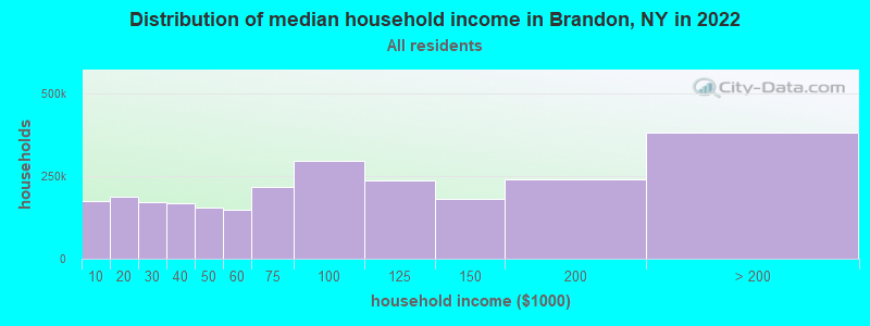
| Brandon: | $53,276 |
| NY: | $79,557 |
Estimated per capita income in 2022: $26,290 (it was $13,663 in 2000)
Brandon town income, earnings, and wages data
Estimated median house or condo value in 2022: $85,078 (it was $36,900 in 2000)
| Brandon: | $85,078 |
| NY: | $400,400 |
Mean prices in 2022: all housing units: $219,333; detached houses: $244,011; townhouses or other attached units: $364,147; in 2-unit structures: $197,583; in 3-to-4-unit structures: $157,263; in 5-or-more-unit structures: $800,159; mobile homes: $60,247
Detailed information about poverty and poor residents in Brandon, NY


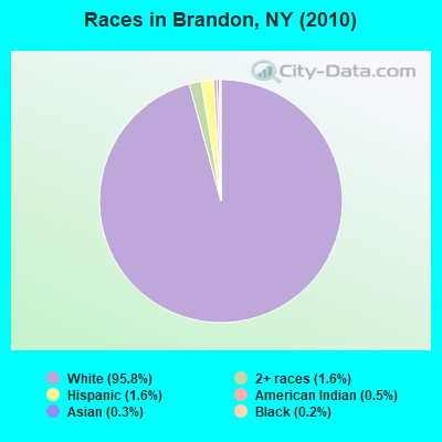
- 55395.8%White alone
- 91.6%Two or more races
- 91.6%Hispanic
- 30.5%American Indian alone
- 20.3%Asian alone
- 10.2%Black alone
Races in Brandon detailed stats: ancestries, foreign born residents, place of birth
 Recent articles from our blog. Our writers, many of them Ph.D. graduates or candidates, create easy-to-read articles on a wide variety of topics.
Ancestries: French (41.1%), Irish (16.2%), English (15.9%), United States (10.7%), German (8.1%), Italian (4.6%).
Current Local Time: EST time zone
Land area: 41.3 square miles.
Population density: 14 people per square mile (very low).
7 residents are foreign born
| This town: | 1.3% |
| New York: | 20.4% |
| Brandon town: | 2.3% ($850) |
| New York: | 1.9% ($2,847) |
Nearest city with pop. 50,000+: Utica, NY  (121.3 miles , pop. 60,651).
Nearest city with pop. 200,000+: Rochester, NY (192.8 miles , pop. 219,773).
Nearest city with pop. 1,000,000+: Bronx, NY (271.5 miles , pop. 1,332,650).
Nearest cities:
), ), ), ), Latitude: 44.75 N, Longitude: 74.43 W
Area code commonly used in this area: 518
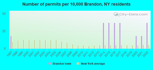
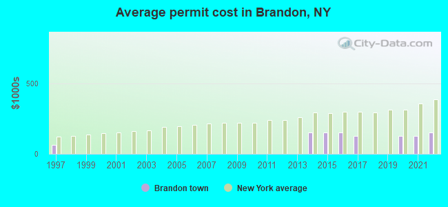
Single-family new house construction building permits:
- 2022: 2 buildings, average cost: $152,500
- 2021: 1 building, cost: $125,000
- 2020: 1 building, cost: $125,000
- 2017: 2 buildings, average cost: $127,500
- 2016: 2 buildings, average cost: $150,000
- 2015: 2 buildings, average cost: $150,000
- 2014: 2 buildings, average cost: $150,000
- 1997: 1 building, cost: $65,000
| Here: | 4.6% |
| New York: | 4.4% |
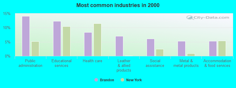
- Public administration (14.0%)
- Educational services (12.3%)
- Health care (8.3%)
- Leather & allied products (7.0%)
- Social assistance (6.1%)
- Metal & metal products (5.3%)
- Accommodation & food services (5.3%)
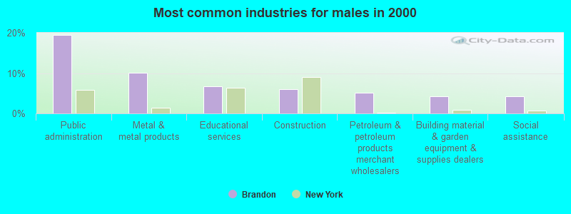
- Public administration (19.5%)
- Metal & metal products (10.2%)
- Educational services (6.8%)
- Construction (5.9%)
- Petroleum & petroleum products merchant wholesalers (5.1%)
- Building material & garden equipment & supplies dealers (4.2%)
- Social assistance (4.2%)
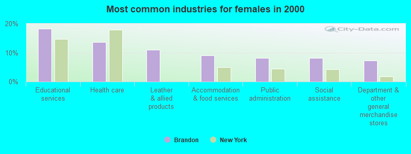
- Educational services (18.2%)
- Health care (13.6%)
- Leather & allied products (10.9%)
- Accommodation & food services (9.1%)
- Public administration (8.2%)
- Social assistance (8.2%)
- Department & other general merchandise stores (7.3%)
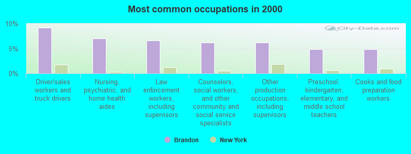
- Driver/sales workers and truck drivers (9.2%)
- Nursing, psychiatric, and home health aides (7.0%)
- Law enforcement workers, including supervisors (6.6%)
- Counselors, social workers, and other community and social service specialists (6.1%)
- Other production occupations, including supervisors (6.1%)
- Preschool, kindergarten, elementary, and middle school teachers (4.8%)
- Cooks and food preparation workers (4.8%)

- Driver/sales workers and truck drivers (17.8%)
- Law enforcement workers, including supervisors (12.7%)
- Counselors, social workers, and other community and social service specialists (5.9%)
- Other management occupations, except farmers and farm managers (5.1%)
- Nursing, psychiatric, and home health aides (5.1%)
- Vehicle and mobile equipment mechanics, installers, and repairers (5.1%)
- Other production occupations, including supervisors (5.1%)
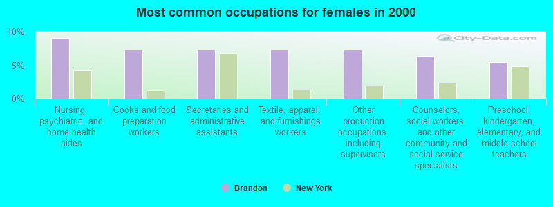
- Nursing, psychiatric, and home health aides (9.1%)
- Cooks and food preparation workers (7.3%)
- Secretaries and administrative assistants (7.3%)
- Textile, apparel, and furnishings workers (7.3%)
- Other production occupations, including supervisors (7.3%)
- Counselors, social workers, and other community and social service specialists (6.4%)
- Preschool, kindergarten, elementary, and middle school teachers (5.5%)
Average climate in Brandon, New York
Based on data reported by over 4,000 weather stations


(lower is better)
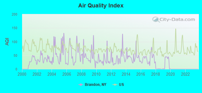
Air Quality Index (AQI) level in 2019 was 24.7. This is significantly better than average.
| City: | 24.7 |
| U.S.: | 72.6 |

Nitrogen Dioxide (NO2) [ppb] level in 2017 was 1.66. This is significantly better than average. Closest monitor was 20.6 miles away from the city center.
| City: | 1.66 |
| U.S.: | 5.11 |
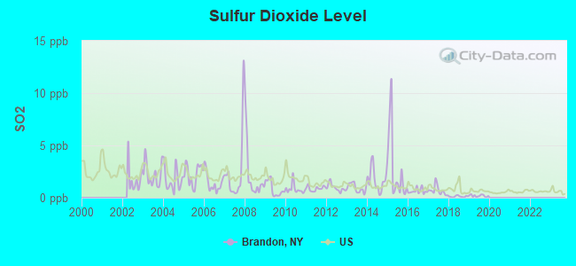
Sulfur Dioxide (SO2) [ppb] level in 2019 was 0.184. This is significantly better than average. Closest monitor was 20.6 miles away from the city center.
| City: | 0.184 |
| U.S.: | 1.515 |
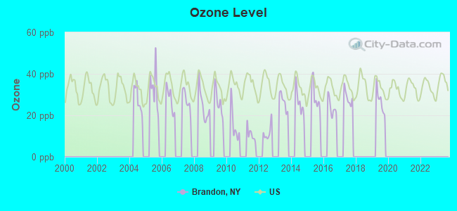
Ozone [ppb] level in 2019 was 26.9. This is better than average. Closest monitor was 20.6 miles away from the city center.
| City: | 26.9 |
| U.S.: | 33.3 |
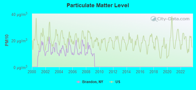
Particulate Matter (PM10) [µg/m3] level in 2008 was 12.5. This is significantly better than average. Closest monitor was 20.6 miles away from the city center.
| City: | 12.5 |
| U.S.: | 19.2 |
Earthquake activity:
Brandon-area historical earthquake activity is above New York state average. It is 77% smaller than the overall U.S. average.On 4/20/2002 at 10:50:47, a magnitude 5.3 (5.3 ML, Depth: 3.0 mi, Class: Moderate, Intensity: VI - VII) earthquake occurred 39.6 miles away from the city center
On 10/7/1983 at 10:18:46, a magnitude 5.3 (5.1 MB, 5.3 LG, 5.1 ML) earthquake occurred 55.4 miles away from Brandon center
On 4/20/2002 at 10:50:47, a magnitude 5.2 (5.2 MB, 4.2 MS, 5.2 MW, 5.0 MW) earthquake occurred 39.4 miles away from Brandon center
On 1/19/1982 at 00:14:42, a magnitude 4.7 (4.5 MB, 4.7 MD, 4.5 LG, Class: Light, Intensity: IV - V) earthquake occurred 164.9 miles away from Brandon center
On 10/16/2012 at 23:12:25, a magnitude 4.7 (4.7 ML, Depth: 10.0 mi) earthquake occurred 203.4 miles away from Brandon center
On 4/8/2003 at 15:06:14, a magnitude 3.7 (3.7 MB, Depth: 6.2 mi, Class: Light, Intensity: II - III) earthquake occurred 10.4 miles away from Brandon center
Magnitude types: regional Lg-wave magnitude (LG), body-wave magnitude (MB), duration magnitude (MD), local magnitude (ML), surface-wave magnitude (MS), moment magnitude (MW)
Natural disasters:
The number of natural disasters in Franklin County (15) is near the US average (15).Major Disasters (Presidential) Declared: 9
Emergencies Declared: 5
Causes of natural disasters: Floods: 5, Storms: 5, Hurricanes: 3, Winter Storms: 2, Blizzard: 1, Earthquake: 1, Power Outage: 1, Snowstorm: 1, Tornado: 1, Wind: 1, Other: 2 (Note: some incidents may be assigned to more than one category).
Hospitals and medical centers near Brandon:
- FRANKLIN COUNTY NURSING HOME (Nursing Home, about 9 miles away; MALONE, NY)
- CITIZEN ADVOCATES D/B/A NORTHSTAR INDUSTRIES, INC (Hospital, about 10 miles away; MALONE, NY)
- FRANKLIN COUNTY PUBLIC HEALTH SERVICES CHHA (Home Health Center, about 10 miles away; MALONE, NY)
- ALICE HYDE MEDICAL CENTER Acute Care Hospitals (about 10 miles away; MALONE, NY)
Colleges/universities with over 2000 students nearest to Brandon:
- SUNY College at Potsdam (about 28 miles; Potsdam, NY; Full-time enrollment: 4,307)
- Clarkson University (about 29 miles; Potsdam, NY; FT enrollment: 3,472)
- St Lawrence University (about 38 miles; Canton, NY; FT enrollment: 2,501)
- SUNY College of Technology at Canton (about 39 miles; Canton, NY; FT enrollment: 3,411)
- SUNY College at Plattsburgh (about 48 miles; Plattsburgh, NY; FT enrollment: 5,934)
- Champlain College (about 64 miles; Burlington, VT; FT enrollment: 2,623)
- University of Vermont (about 64 miles; Burlington, VT; FT enrollment: 11,566)
Points of interest:
Cemetery: Brandon Cemetery (1). Display/hide its location on the map
Lakes: Pitcher Pond (A), Spring Pond (B). Display/hide their locations on the map
Streams, rivers, and creeks: Cady Brook (A), Limekiln Brook (B). Display/hide their locations on the map
| This town: | 2.6 people |
| New York: | 2.6 people |
| This town: | 69.8% |
| Whole state: | 63.5% |
| This town: | 9.0% |
| Whole state: | 6.8% |
Likely homosexual households (counted as self-reported same-sex unmarried-partner households)
- Lesbian couples: 0.0% of all households
- Gay men: 0.5% of all households
| This town: | 22.7% |
| Whole state: | 14.6% |
| This town: | 7.9% |
| Whole state: | 7.4% |
3 people in homes or halfway houses for drug/alcohol abuse in 2000
For population 15 years and over in Brandon:
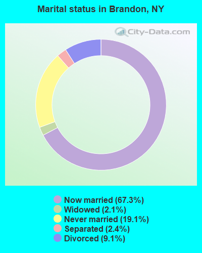
- Never married: 19.1%
- Now married: 67.3%
- Separated: 2.4%
- Widowed: 2.1%
- Divorced: 9.1%
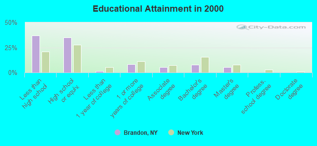
For population 25 years and over in Brandon:
- High school or higher: 63.0%
- Bachelor's degree or higher: 12.9%
- Graduate or professional degree: 5.3%
- Unemployed: 15.6%
- Mean travel time to work (commute): 24.7 minutes
| Here: | 14.9 |
| New York average: | 14.2 |
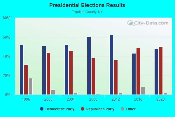
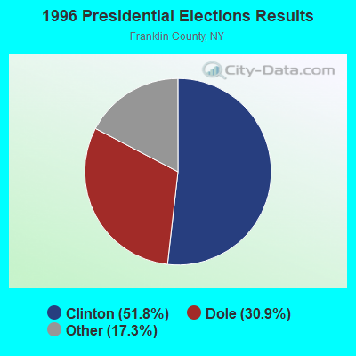
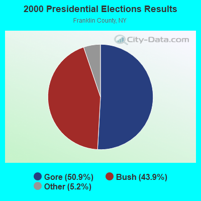
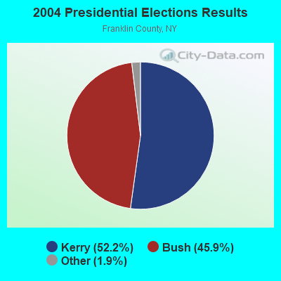
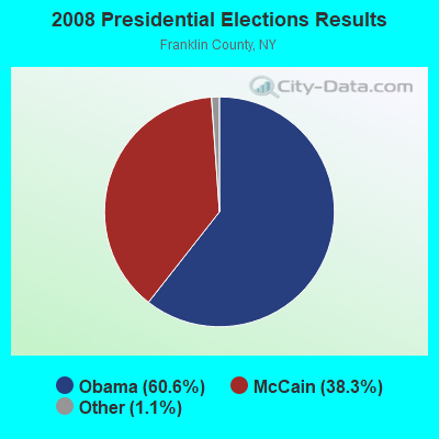
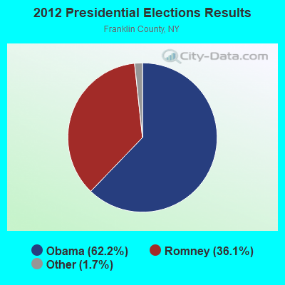
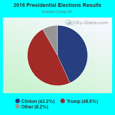

Graphs represent county-level data. Detailed 2008 Election Results
Religion statistics for Brandon, NY (based on Franklin County data)
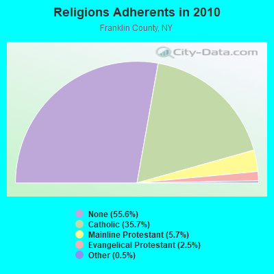
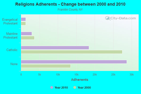
| Religion | Adherents | Congregations |
|---|---|---|
| Catholic | 18,437 | 21 |
| Mainline Protestant | 2,942 | 26 |
| Evangelical Protestant | 1,277 | 19 |
| Other | 253 | 4 |
| None | 28,690 | - |
Food Environment Statistics:
| Franklin County: | 3.57 / 10,000 pop. |
| New York: | 4.13 / 10,000 pop. |
| Franklin County: | 1.39 / 10,000 pop. |
| State: | 0.92 / 10,000 pop. |
| Here: | 4.96 / 10,000 pop. |
| New York: | 1.68 / 10,000 pop. |
| Franklin County: | 6.94 / 10,000 pop. |
| New York: | 8.82 / 10,000 pop. |
| Franklin County: | 8.2% |
| New York: | 8.2% |
| This county: | 26.3% |
| New York: | 23.8% |
| Here: | 13.7% |
| New York: | 15.6% |
Strongest AM radio stations in Brandon:
- WICY (1490 AM; 50 kW; MALONE, NY; Owner: CARTIER COMMUNICATIONS INC.)
- WCHP (760 AM; 35 kW; CHAMPLAIN, NY; Owner: CHAMPLAIN RADIO, INC.)
- WIRD (920 AM; 5 kW; LAKE PLACID, NY; Owner: RADIO LAKE PLACID INC)
- WGY (810 AM; 50 kW; SCHENECTADY, NY; Owner: CLEAR CHANNEL BROADCASTING LICENSES, INC.)
- WEAV (960 AM; 5 kW; PLATTSBURGH, NY; Owner: CLEAR CHANNEL BROADCASTING LICENSES, INC.)
- WVMT (620 AM; 5 kW; BURLINGTON, VT; Owner: SISON BROADCASTING, INC.)
- WTWK (1070 AM; daytime; 5 kW; PLATTSBURGH, NY; Owner: CHAMPLAIN COMMUNICATIONS CORPORATION)
- WNNZ (640 AM; 50 kW; WESTFIELD, MA; Owner: CLEAR CHANNEL BROADCASTING LICENSES, INC.)
- WPTR (1540 AM; 50 kW; ALBANY, NY; Owner: KIMTRON, INC.)
- WRKO (680 AM; 50 kW; BOSTON, MA; Owner: ENTERCOM BOSTON LICENSE, LLC)
- WYBG (1050 AM; 1 kW; MASSENA, NY)
- WCRN (830 AM; 50 kW; WORCESTER, MA; Owner: CARTER BROADCASTING CORPORATION)
- WMSA (1340 AM; 1 kW; MASSENA, NY; Owner: SEAWAY BROADCASTING, INC.)
Strongest FM radio stations in Brandon:
- WYUL (94.7 FM; CHATEAUGAY, NY; Owner: CARTIER COMMUNICATIONS INC.)
- WSLO (90.9 FM; MALONE, NY; Owner: THE ST. LAWRENCE UNIVERSITY)
- WVNV (96.5 FM; MALONE, NY; Owner: CARTIER COMMUNICATIONS INC.)
- WCEL (91.9 FM; PLATTSBURGH, NY; Owner: WAMC)
- WRGR (102.3 FM; TUPPER LAKE, NY; Owner: RADIO LAKE PLACID, INC.)
- WXLU (88.3 FM; PERU, NY; Owner: THE ST. LAWRENCE UNIVERSITY)
- WBTZ (99.9 FM; PLATTSBURGH, NY; Owner: PLATTSBURGH BROADCASTING CORPORATION)
- W211AP (90.1 FM; MALONE, NY; Owner: MARS HILL BROADCASTING CO., INC.)
TV broadcast stations around Brandon:
- WNPI-TV (Channel 18; NORWOOD, NY; Owner: ST. LAWRENCE VALLEY EDUCATIONAL TV COUNCIL, INC)
- W14BU (Channel 14; MASSENA, NY; Owner: DAVID WELCH)
- W25BX (Channel 25; MASSENA, NY; Owner: NELLIE GAJESKI)
- W36BN (Channel 36; MASSENA, NY; Owner: NELLIE GAJESKI)
- W65CR (Channel 65; MASSENA, NY; Owner: ROBERT G. JUILLERAT)
- W49BI (Channel 49; ELLENBURG, NY; Owner: PLATTSBURGH PARTNERS)
- WCFE-TV (Channel 57; PLATTSBURGH, NY; Owner: MOUNTAIN LAKE PUBLIC TELEVISION COUNCIL)
- W20BA (Channel 20; MASSENA, NY; Owner: NATIONAL MINORITY T.V., INC.)
- W60AF (Channel 60; MALONE, NY; Owner: C-22 FCC LICENSEE SUBSIDIARY, LLC)
- National Bridge Inventory (NBI) Statistics
- 4Number of bridges
- 13ft / 4.3mTotal length
- $1,486,000Total costs
- 419Total average daily traffic
- 29Total average daily truck traffic
- 587Total future (year 2035) average daily traffic
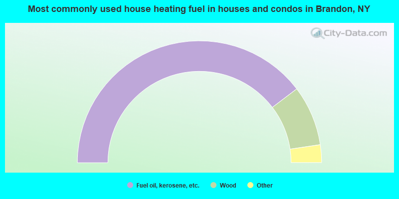
- 79.3%Fuel oil, kerosene, etc.
- 16.0%Wood
- 3.6%Bottled, tank, or LP gas
- 1.2%Electricity
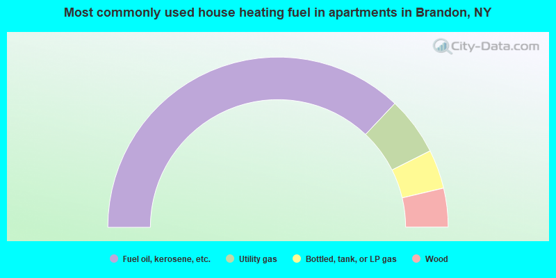
- 74.1%Fuel oil, kerosene, etc.
- 11.1%Utility gas
- 7.4%Bottled, tank, or LP gas
- 7.4%Wood
Brandon compared to New York state average:
- Median house value significantly below state average.
- Black race population percentage significantly below state average.
- Hispanic race population percentage significantly below state average.
- Foreign-born population percentage significantly below state average.
- Renting percentage significantly below state average.
- Length of stay since moving in significantly above state average.
- Number of rooms per house significantly below state average.
- House age significantly below state average.
- Number of college students significantly below state average.
- Percentage of population with a bachelor's degree or higher below state average.