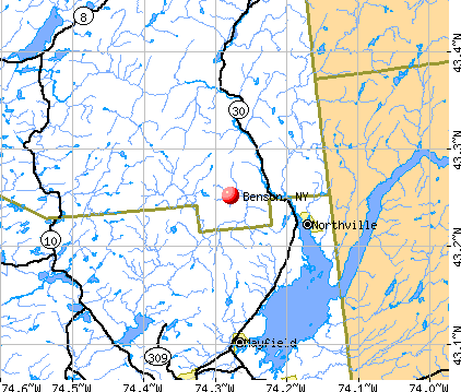
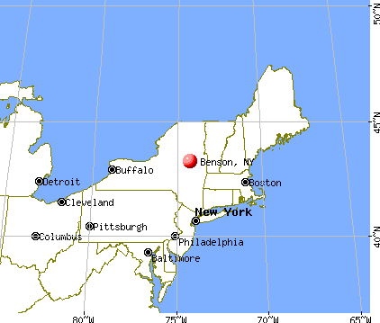
Benson, New York
Submit your own pictures of this town and show them to the world
- OSM Map
- General Map
- Google Map
- MSN Map
Population change since 2000: -4.5%
 |
| Males: 97 | |
| Females: 95 |
| Median resident age: | 46.0 years |
| New York median age: | 40.7 years |
| Benson: | $97,716 |
| NY: | $79,557 |
Estimated per capita income in 2022: $42,250 (it was $20,992 in 2000)
Benson town income, earnings, and wages data
Estimated median house or condo value in 2022: $181,629 (it was $75,000 in 2000)
| Benson: | $181,629 |
| NY: | $400,400 |
Mean prices in 2022: all housing units: $276,911; detached houses: $295,280; townhouses or other attached units: $526,676; in 2-unit structures: $315,059; mobile homes: $136,992


- 17892.7%White alone
- 126.2%Two or more races
- 10.5%American Indian alone
- 10.5%Hispanic

Races in Benson detailed stats: ancestries, foreign born residents, place of birth
 Recent articles from our blog. Our writers, many of them Ph.D. graduates or candidates, create easy-to-read articles on a wide variety of topics.


Latest news from Benson, NY collected exclusively by city-data.com from local newspapers, TV, and radio stations
Ancestries: Irish (31.8%), German (25.9%), Italian (17.4%), Dutch (7.5%), Polish (7.0%), English (5.0%).
Current Local Time: EST time zone
Elevation: 1156 feet
Land area: 82.7 square miles.
Population density: 2.3 people per square mile (very low).
4 residents are foreign born
| This town: | 2.0% |
| New York: | 20.4% |
| Benson town: | 1.1% ($850) |
| New York: | 1.9% ($2,847) |
Nearest city with pop. 50,000+: Schenectady, NY  (35.6 miles , pop. 61,821).
Nearest city with pop. 200,000+: Bronx, NY (167.7 miles , pop. 1,332,650).
Nearest cities:
), ), ), ), ), )Latitude: 43.25 N, Longitude: 74.28 W
Area code commonly used in this area: 518


Single-family new house construction building permits:
- 2020: 1 building, cost: $120,000
| Here: | 7.4% |
| New York: | 4.4% |

- Public administration (12.0%)
- Health care (10.2%)
- Educational services (9.3%)
- Social assistance (8.3%)
- Accommodation & food services (7.4%)
- Motor vehicle & parts dealers (6.5%)
- Food & beverage stores (5.6%)

- Public administration (17.5%)
- Motor vehicle & parts dealers (11.1%)
- Accommodation & food services (9.5%)
- Plastics & rubber products (6.3%)
- Printing & related support activities (4.8%)
- Leather & allied products (4.8%)
- Paper (4.8%)

- Educational services (22.2%)
- Health care (20.0%)
- Social assistance (13.3%)
- Department & other general merchandise stores (6.7%)
- Computer & electronic products (6.7%)
- Food & beverage stores (6.7%)
- Professional, scientific, technical services (6.7%)

- Other management occupations, except farmers and farm managers (7.4%)
- Other office and administrative support workers, including supervisors (6.5%)
- Cashiers (5.6%)
- Other production occupations, including supervisors (5.6%)
- Health technologists and technicians (5.6%)
- Electrical equipment mechanics and other installation, maintenance, and repair workers, including supervisors (5.6%)
- Engineers (4.6%)

- Other office and administrative support workers, including supervisors (11.1%)
- Other management occupations, except farmers and farm managers (9.5%)
- Electrical equipment mechanics and other installation, maintenance, and repair workers, including supervisors (9.5%)
- Other production occupations, including supervisors (9.5%)
- Engineers (7.9%)
- Information and record clerks, except customer service representatives (4.8%)
- Therapists (4.8%)

- Preschool, kindergarten, elementary, and middle school teachers (8.9%)
- Health technologists and technicians (8.9%)
- Other teachers, instructors, education, training, and library occupations (6.7%)
- Cashiers (6.7%)
- Material recording, scheduling, dispatching, and distributing workers (6.7%)
- Printing workers (6.7%)
- Nursing, psychiatric, and home health aides (4.4%)
Average climate in Benson, New York
Based on data reported by over 4,000 weather stations


(lower is better)

Air Quality Index (AQI) level in 2023 was 52.8. This is better than average.
| City: | 52.8 |
| U.S.: | 72.6 |

Sulfur Dioxide (SO2) [ppb] level in 2023 was 0.0978. This is significantly better than average. Closest monitor was 14.2 miles away from the city center.
| City: | 0.0978 |
| U.S.: | 1.5147 |

Ozone [ppb] level in 2023 was 31.2. This is about average. Closest monitor was 18.2 miles away from the city center.
| City: | 31.2 |
| U.S.: | 33.3 |
Tornado activity:
Benson-area historical tornado activity is slightly below New York state average. It is 72% smaller than the overall U.S. average.
On 7/10/1989, a category F4 (max. wind speeds 207-260 mph) tornado 31.8 miles away from the Benson town center injured 20 people and caused between $5,000,000 and $50,000,000 in damages.
On 6/16/1974, a category F3 (max. wind speeds 158-206 mph) tornado 30.5 miles away from the town center caused between $500,000 and $5,000,000 in damages.
Earthquake activity:
Benson-area historical earthquake activity is significantly above New York state average. It is 68% smaller than the overall U.S. average.On 10/7/1983 at 10:18:46, a magnitude 5.3 (5.1 MB, 5.3 LG, 5.1 ML, Class: Moderate, Intensity: VI - VII) earthquake occurred 48.6 miles away from Benson center
On 4/20/2002 at 10:50:47, a magnitude 5.3 (5.3 ML, Depth: 3.0 mi) earthquake occurred 91.9 miles away from Benson center
On 4/20/2002 at 10:50:47, a magnitude 5.2 (5.2 MB, 4.2 MS, 5.2 MW, 5.0 MW) earthquake occurred 89.9 miles away from Benson center
On 1/19/1982 at 00:14:42, a magnitude 4.7 (4.5 MB, 4.7 MD, 4.5 LG, Class: Light, Intensity: IV - V) earthquake occurred 135.7 miles away from the city center
On 6/17/1991 at 08:53:16, a magnitude 4.1 (4.0 MB, 4.0 LG, Depth: 3.1 mi) earthquake occurred 47.6 miles away from Benson center
On 10/16/2012 at 23:12:25, a magnitude 4.7 (4.7 ML, Depth: 10.0 mi) earthquake occurred 183.5 miles away from Benson center
Magnitude types: regional Lg-wave magnitude (LG), body-wave magnitude (MB), duration magnitude (MD), local magnitude (ML), surface-wave magnitude (MS), moment magnitude (MW)
Natural disasters:
The number of natural disasters in Hamilton County (14) is near the US average (15).Major Disasters (Presidential) Declared: 7
Emergencies Declared: 5
Causes of natural disasters: Floods: 5, Storms: 5, Hurricanes: 3, Winds: 2, Blizzard: 1, Earthquake: 1, Power Outage: 1, Snowstorm: 1, Tornado: 1, Winter Storm: 1, Other: 2 (Note: some incidents may be assigned to more than one category).

Colleges/universities with over 2000 students nearest to Benson:
- Fulton-Montgomery Community College (about 19 miles; Johnstown, NY; Full-time enrollment: 2,043)
- Skidmore College (about 28 miles; Saratoga Springs, NY; FT enrollment: 2,753)
- SUNY Empire State College (about 28 miles; Saratoga Springs, NY; FT enrollment: 9,473)
- Adirondack Community College (about 33 miles; Queensbury, NY; FT enrollment: 2,826)
- Schenectady County Community College (about 35 miles; Schenectady, NY; FT enrollment: 3,676)
- Union College (about 35 miles; Schenectady, NY; FT enrollment: 2,075)
- Herkimer County Community College (about 40 miles; Herkimer, NY; FT enrollment: 2,774)
Points of interest:
Notable location: Silver Lake Lean-to (A). Display/hide its location on the map
Lakes and swamps: Meco Lake (A), Rock Lake (B), Silver Lake (C), Three Ponds (D), White Lake (E), Woods Lake (F), Canary Pond (G), Duck Lake (H). Display/hide their locations on the map
Streams, rivers, and creeks: Trypoli Creek (A), Goldmine Creek (B), Jack Green Creek (C), West Stony Creek (D), Abner Brook (E), King Vly Creek (F), Hatch Brook (G). Display/hide their locations on the map
Birthplace of: Helen Corbitt - Legendary cook and author who defined Texas cooking for nearly 50 years.
| This town: | 2.2 people |
| New York: | 2.6 people |
| This town: | 67.8% |
| Whole state: | 63.5% |
| This town: | 10.3% |
| Whole state: | 6.8% |
Likely homosexual households (counted as self-reported same-sex unmarried-partner households)
- Lesbian couples: 0.0% of all households
- Gay men: 1.1% of all households
| This town: | 2.4% |
| Whole state: | 14.6% |
For population 15 years and over in Benson:

- Never married: 22.2%
- Now married: 64.3%
- Separated: 1.8%
- Widowed: 7.0%
- Divorced: 4.7%
For population 25 years and over in Benson:
- High school or higher: 86.8%
- Bachelor's degree or higher: 25.0%
- Graduate or professional degree: 6.2%
- Unemployed: 6.1%
- Mean travel time to work (commute): 31.9 minutes


| Here: | 9.6 |
| New York average: | 14.2 |
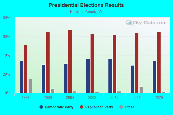
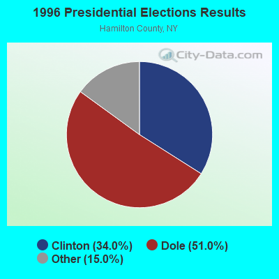
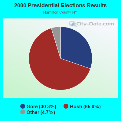
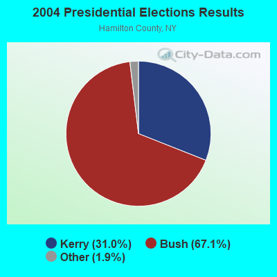
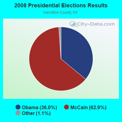
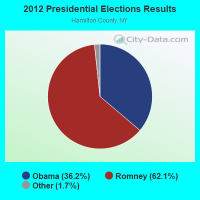
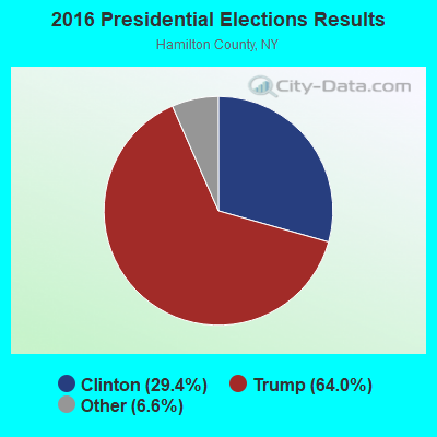
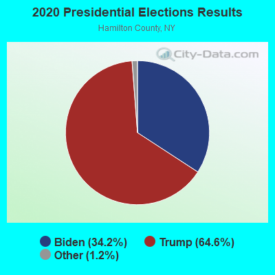
Graphs represent county-level data. Detailed 2008 Election Results
Religion statistics for Benson, NY (based on Hamilton County data)
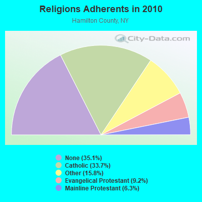
| Religion | Adherents | Congregations |
|---|---|---|
| Catholic | 1,629 | 6 |
| Other | 762 | 1 |
| Evangelical Protestant | 445 | 8 |
| Mainline Protestant | 304 | 9 |
| None | 1,696 | - |
Food Environment Statistics:
| Here: | 5.94 / 10,000 pop. |
| New York: | 4.13 / 10,000 pop. |
| This county: | 15.83 / 10,000 pop. |
| State: | 1.68 / 10,000 pop. |
| Hamilton County: | 39.57 / 10,000 pop. |
| New York: | 8.82 / 10,000 pop. |
| This county: | 10.5% |
| New York: | 8.2% |
| Here: | 24.2% |
| New York: | 23.8% |
| Hamilton County: | 15.9% |
| State: | 15.6% |
Strongest AM radio stations in Benson:
- WGY (810 AM; 50 kW; SCHENECTADY, NY; Owner: CLEAR CHANNEL BROADCASTING LICENSES, INC.)
- WPTR (1540 AM; 50 kW; ALBANY, NY; Owner: KIMTRON, INC.)
- WNNZ (640 AM; 50 kW; WESTFIELD, MA; Owner: CLEAR CHANNEL BROADCASTING LICENSES, INC.)
- WIZR (930 AM; 1 kW; JOHNSTOWN, NY; Owner: 6 JOHNSON ROAD LICENSES, INC.)
- WOFX (980 AM; 5 kW; TROY, NY)
- WABY (1160 AM; 5 kW; MECHANICVILLE, NY; Owner: ANASTOS MEDIA GROUP, INC.)
- WCRN (830 AM; 50 kW; WORCESTER, MA; Owner: CARTER BROADCASTING CORPORATION)
- WENT (1340 AM; 1 kW; GLOVERSVILLE, NY; Owner: WHITNEY RADIO BROADCASTING, INC.)
- WTIC (1080 AM; 50 kW; HARTFORD, CT; Owner: INFINITY RADIO OPERATIONS INC.)
- WCHP (760 AM; 35 kW; CHAMPLAIN, NY; Owner: CHAMPLAIN RADIO, INC.)
- WROW (590 AM; 5 kW; ALBANY, NY; Owner: 6 JOHNSON ROAD LICENSES, INC.)
- WMCA (570 AM; 50 kW; NEW YORK, NY; Owner: SALEM MEDIA OF NEW YORK, LLC)
- WICY (1490 AM; 50 kW; MALONE, NY; Owner: CARTIER COMMUNICATIONS INC.)
Strongest FM radio stations in Benson:
- WXLG (89.9 FM; NORTH CREEK, NY; Owner: THE ST. LAWRENCE UNIVERSITY)
- WKBE (100.3 FM; WARRENSBURG, NY; Owner: 6 JOHNSON ROAD LICENSES, INC.)
- WCKM-FM (99.1 FM; LAKE GEORGE, NY; Owner: ENTERTRONICS, INC.)
- WNYQ (105.7 FM; QUEENSBURY, NY; Owner: VOX NEW YORK, L.L.C.)
- WBKK (97.7 FM; AMSTERDAM, NY; Owner: GEM ASSOCIATES, L. P.)
- WXLH (91.3 FM; BLUE MOUNTAIN LAKE, NY; Owner: THE ST. LAWRENCE UNIVERSITY)
- WFFG-FM (107.1 FM; CORINTH, NY; Owner: VOX NEW YORK, L.L.C.)
- WBAR-FM (94.7 FM; LAKE LUZERNE, NY; Owner: CAPITAL MEDIA CORPORATION)
- WEQX (102.7 FM; MANCHESTER, VT; Owner: NORTHSHIRE COMMUNICATIONS, INC.)
- WCQL (95.9 FM; GLENS FALLS, NY; Owner: ENTERTRONICS, INC.)
- WJAN (95.1 FM; SUNDERLAND, VT; Owner: 6 JOHNSON ROAD LICENSES, INC.)
- WKRD (93.7 FM; SCOTIA, NY; Owner: DOT COMMUNICATIONS, INC.)
- WBUG-FM (101.1 FM; FORT PLAIN, NY; Owner: ROSER COMMUNICATIONS NETWORK, INC.)
- WNGN (91.9 FM; ARGYLE, NY; Owner: NORTHEAST GOSPEL BROADCASTING INC)
- WJIV (101.9 FM; CHERRY VALLEY, NY; Owner: CHRISTIAN BROADCASTING SYSTEM, LTD.)
- WQBJ (103.5 FM; COBLESKILL, NY; Owner: REGENT LICENSEE OF MANSFIELD, INC.)
- WPGL (90.7 FM; PATTERSONVILLE, NY; Owner: SOUND OF LIFE, INC.)
- WAJZ (96.3 FM; VOORHEESVILLE, NY; Owner: 6 JOHNSON ROAD LICENSES, INC.)
- WYJB (95.5 FM; ALBANY, NY; Owner: 6 JOHNSON ROAD LICENSES, INC.)
- WSSK (89.7 FM; SARATOGA SPRINGS, NY; Owner: SOUND OF LIFE, INC.)
TV broadcast stations around Benson:
- WYPX (Channel 55; AMSTERDAM, NY; Owner: PAXSON ALBANY LICENSE, INC.)
- WKTV (Channel 2; UTICA, NY; Owner: SMITH TELEVISION OF NEW YORK LICENSE HOLDINGS, INC.)
- WFNY-CA (Channel 49; GLOVERSVILLE, NY; Owner: MICHAEL A. SLEEZER)
- National Bridge Inventory (NBI) Statistics
- 5Number of bridges
- 66ft / 20.1mTotal length
- $6,084,000Total costs
- 3,382Total average daily traffic
- 302Total average daily truck traffic
- 3,817Total future (year 2036) average daily traffic
FCC Registered Broadcast Land Mobile Towers:
1- Cathead Mountain (Lat: 43.281750 Lon: -74.288750), Call Sign: WNIG200,
Assigned Frequencies: 154.695 MHz, 155.445 MHz, 155.370 MHz, 155.475 MHz, 155.565 MHz, Grant Date: 12/10/2021, Expiration Date: 03/05/2032, Registrant: New York State Police, 1220 Washington Ave, Bldg 22, Albany, NY 12226-2252, Phone: (518) 457-9466, Fax: (518) 457-5676, Email:
FCC Registered Microwave Towers:
1- STATION, Cathead Mountain (Lat: 43.283556 Lon: -74.288944), Type: Ltower, Structure height: 17.7 m, Overall height: 32.9 m, Call Sign: WNEO491,
Assigned Frequencies: 6123.10 MHz, 6286.19 MHz, 6197.24 MHz, Grant Date: 11/21/2017, Expiration Date: 02/08/2028, Registrant: Acd Telecom, 103 Commerce Street, Suite 180, Lake Mary, FL 32746, Phone: (407) 333-2300, Email:

- 62.3%Fuel oil, kerosene, etc.
- 21.3%Wood
- 13.1%Bottled, tank, or LP gas
- 3.3%Electricity

- 43.8%Wood
- 37.5%Fuel oil, kerosene, etc.
- 18.8%Bottled, tank, or LP gas
Benson compared to New York state average:
- Median house value below state average.
- Unemployed percentage below state average.
- Black race population percentage significantly below state average.
- Hispanic race population percentage significantly below state average.
- Median age above state average.
- Foreign-born population percentage significantly below state average.
- Renting percentage significantly below state average.
- Length of stay since moving in significantly above state average.
- Number of rooms per house significantly below state average.
- House age significantly below state average.

|
Total of 6 patent applications in 2008-2024.