Bridge Statistics for Western, New York (NY)
Condition, Traffic, Stress, Structural Evaluation, Project Costs
- National Bridge Inventory (NBI) Statistics
- 16Number of bridges
- 112ft / 34.3mTotal length
- $14,534,000Total costs
- 7,761Total average daily traffic
- 424Total average daily truck traffic
- 8,753Total future (year 2036) average daily traffic
- National Bridge Inventory (NBI) Registered Bridges for Western
- No street view available for this location
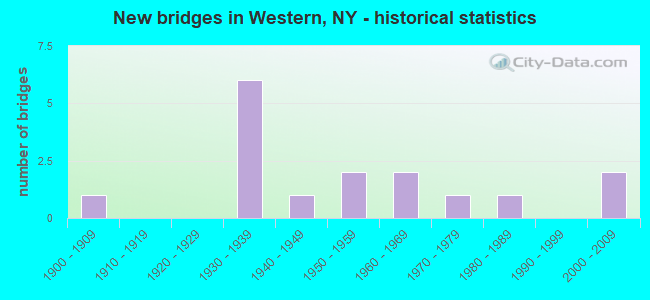
- New bridges - historical statistics
- 11900-1909
- 61930-1939
- 11940-1949
- 21950-1959
- 21960-1969
- 11970-1979
- 11980-1989
- 22000-2009

- Reconstructed bridges - Historical Statistics
- 51980-1989
- 41990-1999
- 12000-2009
- 12010-2019

- Bridge Condition - Deck
- 25.0%Very good
- 43.8%Good
- 25.0%Satisfactory
- 6.3%Fair

- Bridge Condition - Superstructure
- 12.5%Excellent
- 6.3%Very good
- 25.0%Good
- 12.5%Satisfactory
- 31.3%Fair
- 6.3%Poor
- 6.3%Critical

- Bridge Condition - Substructure
- 18.8%Very good
- 6.3%Good
- 37.5%Satisfactory
- 31.3%Fair
- 6.3%Failed

- Bridge Condition - Channel
- 6.3%Very good
- 12.5%Good
- 43.8%Satisfactory
- 18.8%Fair
- 12.5%Poor
- 6.3%Failed
Find on map >> Show street view
Structure Number: 102577, Location: JCT SH46 &SH274-FRENCHVLL (Lat: 43.324386, Lng: -75.358794), Route carried "on" structure: State highway 46, Year Built: 1960, Year Reconstructed: 2009, Status: Open, Structure Length: 2.23m (7.32ft), Average Daily Traffic: 2,070 (year 2018), Truck Traffic: 5%, Average Future Daily Traffic: 2,082 (year 2040), Design Load: HL 93, Features Intersected: WELLS CREEK
Minimum Vertical Clearance: 30+ m (98+ ft), Kilometerpoint: 42.976, Lanes on structure: 2, Base Highway Network: Yes, Owner: State Highway Agency, Approaching Roadway Width: 11.9m (39.0ft), Material/Design: Prestressed concrete, Design/Construction: Box Beam or Girders - Multiple, Number Of Spans In Main Unit: 1, Length of Maximum Span: 21.9m (71.9ft), Curb-To-Curb Width: 11.8m (38.7ft), Out-to-Out Width: 12.8m (42.0ft)
Condition: Deck: Very good, Superstructure: Excellent, Substructure: Satisfactory, Channel: Satisfactory, Inventory Rating: 59.9 metric tons, Method Used To Determine Inventory Rating: Load Factor (LF), Structural Evaluation: Equal to present minimum criteria, Deck Geometry: Somewhat better than minimum adequacy, Waterway Adequacy: Meets minimum limits, Approach Roadway Alignment: Equal to present desirable criteria, Length Of Structure Improvement: 2.22m (7.28ft), Designated Inspection Frequency: Every 24 months, Inspection Date: October 2021, Bridge Improvement Cost: $752,000, Roadway Improvement Cost: $440,000, Total Project Cost: $1,192,000 ( Estimate for 2021), Deck Structure Type: Concrete Cast-file-Place, Wearing Surface/Protective System: Wearing Surface: Integral Concrete, Deck Protection: Epoxy Coated Reinforcing
Find on map >> Show street view
Structure Number: 102578, Location: 1.7 MI N JCT RTS 46 & 274 (Lat: 43.346433, Lng: -75.368139), Route carried "on" structure: State highway 46, Year Built: 1931, Year Reconstructed: 1990, Status: Open, Structure Length: 2.47m (8.10ft), Average Daily Traffic: 1,499 (year 2020), Truck Traffic: 6%, Average Future Daily Traffic: 1,508 (year 2040), Design Load: HS 20, Features Intersected: STRINGER BROOK
Minimum Vertical Clearance: 30+ m (98+ ft), Kilometerpoint: 45.792, Lanes on structure: 2, Base Highway Network: Yes, Owner: State Highway Agency, Approaching Roadway Width: 7.3m (24.0ft), Skew: 1 degrees, Material/Design: Steel, Design/Construction: Girder and Floorbeam System, Number Of Spans In Main Unit: 1, Length of Maximum Span: 22.8m (74.8ft), Curb or Sidewalk Widths: Left: 1.6m (5.2ft), Right: 0.0m, Curb-To-Curb Width: 7.3m (24.0ft), Out-to-Out Width: 8.4m (27.6ft)
Condition: Deck: Good, Superstructure: Poor, Substructure: Fair, Channel: Satisfactory, Operating Rating: 38.1 metric tons, Method Used To Determine Operating Rating: Load Factor (LF), Inventory Rating: 22.7 metric tons, Method Used To Determine Inventory Rating: Load Factor (LF), Structural Evaluation: Meets minimum limits, Deck Geometry: Meets minimum limits, Waterway Adequacy: Meets minimum limits, Approach Roadway Alignment: Equal to present desirable criteria, Length Of Structure Improvement: 2.46m (8.07ft), Designated Inspection Frequency: Every 24 months, Critical Feature Inspection Frequency: Every 24 months, Inspection Date: September 2020, Critical Feature Inspection Date: September 2020, Bridge Improvement Cost: $541,000, Roadway Improvement Cost: $317,000, Total Project Cost: $858,000 ( Estimate for 2021), Deck Structure Type: Concrete Cast-file-Place, Wearing Surface/Protective System: Wearing Surface: Integral Concrete, Deck Protection: Epoxy Coated Reinforcing
Find on map >> Show street view
Structure Number: 102579, Location: 3.3 MI N JCT RTS 46 & 274 (Lat: 43.377747, Lng: -75.389222), Route carried "on" structure: State highway 46, Year Built: 1932, Year Reconstructed: 1990, Status: Open, Structure Length: 2.29m (7.51ft), Average Daily Traffic: 1,104 (year 2018), Truck Traffic: 5%, Average Future Daily Traffic: 1,110 (year 2040), Design Load: HS 20, Features Intersected: LANSING KILL
Minimum Vertical Clearance: 30+ m (98+ ft), Kilometerpoint: 50.040, Lanes on structure: 2, Base Highway Network: Yes, Owner: State Highway Agency, Approaching Roadway Width: 8.5m (27.9ft), Skew: 3 degrees, Material/Design: Steel, Design/Construction: Girder and Floorbeam System, Number Of Spans In Main Unit: 1, Length of Maximum Span: 21.3m (69.9ft), Curb-To-Curb Width: 7.9m (25.9ft), Out-to-Out Width: 8.8m (28.9ft)
Condition: Deck: Good, Superstructure: Fair, Substructure: Satisfactory, Channel: Satisfactory, Operating Rating: 59.0 metric tons, Method Used To Determine Operating Rating: Allowable Stress (AS), Inventory Rating: 34.5 metric tons, Method Used To Determine Inventory Rating: Allowable Stress (AS), Structural Evaluation: Somewhat better than minimum adequacy, Deck Geometry: Meets minimum limits, Waterway Adequacy: Meets minimum limits, Approach Roadway Alignment: Equal to present desirable criteria, Length Of Structure Improvement: 2.28m (7.48ft), Designated Inspection Frequency: Every 24 months, Critical Feature Inspection Frequency: Every 24 months, Inspection Date: September 2020, Critical Feature Inspection Date: September 2020, Bridge Improvement Cost: $515,000, Roadway Improvement Cost: $301,000, Total Project Cost: $816,000 ( Estimate for 2021), Deck Structure Type: Concrete Cast-file-Place, Wearing Surface/Protective System: Wearing Surface: Integral Concrete
Find on map >> Show street view
Structure Number: 10441, Location: 0.9 MI E JCT RTS 46 & 274 (Lat: 43.322639, Lng: -75.326486), Route carried "on" structure: State highway 274, Year Built: 1931, Year Reconstructed: 1991, Status: Posted for load-capacity, Structure Length: 3.41m (11.19ft), Average Daily Traffic: 365 (year 2017), Truck Traffic: 6%, Average Future Daily Traffic: 511 (year 2037), Design Load: H 15, Features Intersected: BIG BROOK
Minimum Vertical Clearance: 30+ m (98+ ft), Kilometerpoint: 13.966, Lanes on structure: 2, Base Highway Network: Yes, Owner: State Highway Agency, Approaching Roadway Width: 6.1m (20.0ft), Skew: 6 degrees, Material/Design: Steel, Design/Construction: Truss - Thru, Number Of Spans In Main Unit: 1, Length of Maximum Span: 30.4m (99.7ft), Curb-To-Curb Width: 7.3m (24.0ft), Out-to-Out Width: 7.9m (25.9ft)
Condition: Deck: Very good, Superstructure: Satisfactory, Substructure: Fair, Channel: Good, Operating Rating: 40.8 metric tons, Method Used To Determine Operating Rating: Load Factor (LF), Inventory Rating: 25.4 metric tons, Method Used To Determine Inventory Rating: Load Factor (LF), Structural Evaluation: Somewhat better than minimum adequacy, Deck Geometry: Somewhat better than minimum adequacy, Waterway Adequacy: Somewhat better than minimum adequacy, Approach Roadway Alignment: Equal to present desirable criteria, Length Of Structure Improvement: 3.41m (11.19ft), Designated Inspection Frequency: Every 24 months, Critical Feature Inspection Frequency: Every 24 months, Inspection Date: October 2020, Critical Feature Inspection Date: October 2020, Bridge Improvement Cost: $2,709,000, Roadway Improvement Cost: $1,586,000, Total Project Cost: $4,295,000 ( Estimate for 2021), Deck Structure Type: Concrete Cast-file-Place, Wearing Surface/Protective System: Wearing Surface: Integral Concrete
Find on map >> Show street view
Structure Number: 104411, Location: 13MI E JCT RTS 46+274 (Lat: 43.321306, Lng: -75.334694), Route carried "on" structure: State highway 274, Year Built: 1931, Status: Open, Structure Length: 1.28m (4.20ft), Average Daily Traffic: 365 (year 2017), Truck Traffic: 6%, Average Future Daily Traffic: 511 (year 2037), Design Load: H 15, Features Intersected: BIG BROOK
Minimum Vertical Clearance: 30+ m (98+ ft), Kilometerpoint: 14.658, Lanes on structure: 2, Base Highway Network: Yes, Owner: State Highway Agency, Approaching Roadway Width: 6.1m (20.0ft), Material/Design: Steel, Design/Construction: Stringer/Multi-beam, Number Of Spans In Main Unit: 1, Length of Maximum Span: 12.1m (39.7ft), Curb-To-Curb Width: 9.1m (29.9ft), Out-to-Out Width: 9.8m (32.2ft)
Condition: Deck: Fair, Superstructure: Fair, Substructure: Fair, Channel: Satisfactory, Operating Rating: 41.7 metric tons, Method Used To Determine Operating Rating: Load Factor (LF), Inventory Rating: 24.5 metric tons, Method Used To Determine Inventory Rating: Load Factor (LF), Structural Evaluation: Somewhat better than minimum adequacy, Deck Geometry: Equal to present minimum criteria, Waterway Adequacy: Meets minimum limits, Approach Roadway Alignment: Equal to present desirable criteria, Length Of Structure Improvement: 1.31m (4.30ft), Designated Inspection Frequency: Every 24 months, Inspection Date: October 2021, Bridge Improvement Cost: $287,000, Roadway Improvement Cost: $168,000, Total Project Cost: $454,000 ( Estimate for 2021), Deck Structure Type: Concrete Cast-file-Place, Wearing Surface/Protective System: Wearing Surface: Bituminous
Find on map >> Show street view
Structure Number: 104412, Location: 1.6 MI E JCT RTS 46 & 274 (Lat: 43.320969, Lng: -75.338681), Route carried "on" structure: State highway 274, Year Built: 1931, Year Reconstructed: 1990, Status: Open, Structure Length: 1.95m (6.40ft), Average Daily Traffic: 365 (year 2017), Truck Traffic: 6%, Average Future Daily Traffic: 511 (year 2037), Design Load: H 15, Features Intersected: BIG BROOK
Minimum Vertical Clearance: 30+ m (98+ ft), Kilometerpoint: 14.996, Lanes on structure: 2, Base Highway Network: Yes, Owner: State Highway Agency, Approaching Roadway Width: 6.1m (20.0ft), Material/Design: Steel, Design/Construction: Girder and Floorbeam System, Number Of Spans In Main Unit: 1, Length of Maximum Span: 18.2m (59.7ft), Curb-To-Curb Width: 7.3m (24.0ft), Out-to-Out Width: 8.1m (26.6ft)
Condition: Deck: Good, Superstructure: Fair, Substructure: Good, Channel: Very good, Operating Rating: 54.4 metric tons, Method Used To Determine Operating Rating: Load Factor (LF), Inventory Rating: 31.8 metric tons, Method Used To Determine Inventory Rating: Load Factor (LF), Structural Evaluation: Somewhat better than minimum adequacy, Deck Geometry: Somewhat better than minimum adequacy, Waterway Adequacy: Somewhat better than minimum adequacy, Approach Roadway Alignment: Equal to present desirable criteria, Length Of Structure Improvement: 1.95m (6.40ft), Designated Inspection Frequency: Every 24 months, Critical Feature Inspection Frequency: Every 24 months, Inspection Date: October 2020, Critical Feature Inspection Date: October 2020, Bridge Improvement Cost: $428,000, Roadway Improvement Cost: $251,000, Total Project Cost: $679,000 ( Estimate for 2021), Deck Structure Type: Concrete Cast-file-Place, Wearing Surface/Protective System: Wearing Surface: Integral Concrete, Deck Protection: Epoxy Coated Reinforcing
Find on map >> Show street view
Structure Number: 22062, Location: 4 MI NE DELTA LAKE (Lat: 43.325111, Lng: -75.322306), Route carried "on" structure: Other road , Year Built: 1940, Year Reconstructed: 1988, Status: Posted for load, Structure Length: 1.16m (3.81ft), Average Daily Traffic: 9 (year 2018), Truck Traffic: 4%, Average Future Daily Traffic: 13 (year 2038), Features Intersected: BIG BROOK, Facility Carried by Structure: ROSS ROAD
Minimum Vertical Clearance: 30+ m (98+ ft), Kilometerpoint: 0.113, Lanes on structure: 2, Owner: Town or Township Highway Agency, Approaching Roadway Width: 4.3m (14.1ft), Material/Design: Steel, Design/Construction: Stringer/Multi-beam, Number Of Spans In Main Unit: 1, Length of Maximum Span: 10.6m (34.8ft), Curb-To-Curb Width: 5.8m (19.0ft), Out-to-Out Width: 6.1m (20.0ft)
Condition: Deck: Satisfactory, Superstructure: Fair, Substructure: Satisfactory, Channel: Satisfactory, Operating Rating: 92.5 metric tons, Method Used To Determine Operating Rating: Allowable Stress (AS), Inventory Rating: 57.2 metric tons, Method Used To Determine Inventory Rating: Allowable Stress (AS), Structural Evaluation: Somewhat better than minimum adequacy, Deck Geometry: Meets minimum limits, Waterway Adequacy: Meets minimum limits, Approach Roadway Alignment: Meets minimum limits, Bridge Posting: Required (Relationship of Operating Rating to Maximum Legal Load: > 39.9% below), Length Of Structure Improvement: 1.15m (3.77ft), Designated Inspection Frequency: Every 12 months, Inspection Date: April 2021, Bridge Improvement Cost: $161,000, Roadway Improvement Cost: $94,000, Total Project Cost: $255,000 ( Estimate for 2021), Deck Structure Type: Wood or Timber, Wearing Surface/Protective System: Wearing Surface: Wood or Timber
Find on map >> Show street view
Structure Number: 220621, Location: 4 MI NE OF LAKE DELTA (Lat: 43.320475, Lng: -75.321044), Route carried "on" structure: Other road , Year Built: 2004, Status: Open, Structure Length: 1.89m (6.20ft), Average Daily Traffic: 42 (year 2017), Truck Traffic: 5%, Average Future Daily Traffic: 59 (year 2037), Design Load: HS 25 or greater, Features Intersected: BR OF BIG BROOK, Facility Carried by Structure: GILLETTE HILL RD
Minimum Vertical Clearance: 30+ m (98+ ft), Kilometerpoint: 1.239, Lanes on structure: 2, Owner: Town or Township Highway Agency, Approaching Roadway Width: 7.3m (24.0ft), Skew: 3 degrees, Material/Design: Prestressed concrete, Design/Construction: Box Beam or Girders - Multiple, Number Of Spans In Main Unit: 1, Length of Maximum Span: 17.0m (55.8ft), Curb-To-Curb Width: 7.2m (23.6ft), Out-to-Out Width: 8.7m (28.5ft)
Condition: Deck: Good, Superstructure: Good, Substructure: Very good, Channel: Fair, Inventory Rating: 71.7 metric tons, Method Used To Determine Inventory Rating: Load Factor (LF), Structural Evaluation: Better than present minimum criteria, Deck Geometry: Somewhat better than minimum adequacy, Waterway Adequacy: Somewhat better than minimum adequacy, Approach Roadway Alignment: Equal to present desirable criteria, Length Of Structure Improvement: 1.88m (6.17ft), Designated Inspection Frequency: Every 24 months, Inspection Date: June 2020, Bridge Improvement Cost: $491,000, Roadway Improvement Cost: $288,000, Total Project Cost: $779,000 ( Estimate for 2021), Wearing Surface/Protective System: Wearing Surface: Monolithic Concrete
Find on map >> Show street view
Structure Number: 220622, Location: 2.5 MI NE LAKE DELTA (Lat: 43.321406, Lng: -75.347347), Route carried "on" structure: Other road , Year Built: 1975, Year Reconstructed: 2015, Status: Open, Structure Length: 1.58m (5.18ft), Average Daily Traffic: 20 (year 2017), Truck Traffic: 4%, Average Future Daily Traffic: 28 (year 2037), Design Load: HS 20, Features Intersected: BIG BROOK, Facility Carried by Structure: OLIVER ROAD
Minimum Vertical Clearance: 30+ m (98+ ft), Kilometerpoint: 0.032, Lanes on structure: 1, Owner: Town or Township Highway Agency, Approaching Roadway Width: 5.2m (17.1ft), Material/Design: Steel, Design/Construction: Stringer/Multi-beam, Number Of Spans In Main Unit: 1, Length of Maximum Span: 14.3m (46.9ft), Curb-To-Curb Width: 5.1m (16.7ft), Out-to-Out Width: 5.5m (18.0ft)
Condition: Deck: Very good, Superstructure: Very good, Substructure: Satisfactory, Channel: Satisfactory, Operating Rating: 59.9 metric tons, Method Used To Determine Operating Rating: Load Factor (LF), Inventory Rating: 36.3 metric tons, Method Used To Determine Inventory Rating: Load Factor (LF), Structural Evaluation: Equal to present minimum criteria, Deck Geometry: High priority of corrective action, Waterway Adequacy: Meets minimum limits, Approach Roadway Alignment: Better than present minimum criteria, Length Of Structure Improvement: 1.58m (5.18ft), Designated Inspection Frequency: Every 24 months, Inspection Date: October 2021, Bridge Improvement Cost: $260,000, Roadway Improvement Cost: $152,000, Total Project Cost: $412,000 ( Estimate for 2021), Deck Structure Type: Wood or Timber, Wearing Surface/Protective System: Wearing Surface: Wood or Timber
Find on map >> Show street view
Structure Number: 220623, Location: 1 MI SW JCT SH 46 & SH274 (Lat: 43.314000, Lng: -75.384789), Route carried "on" structure: Other road , Year Built: 1966, Year Reconstructed: 1994, Status: Open, Structure Length: 0.91m (2.99ft), Average Daily Traffic: 302 (year 2017), Truck Traffic: 4%, Average Future Daily Traffic: 423 (year 2037), Design Load: HS 20, Features Intersected: DEANS GULF BROOK, Facility Carried by Structure: RIVER ROAD
Minimum Vertical Clearance: 30+ m (98+ ft), Kilometerpoint: 0.032, Lanes on structure: 2, Owner: Town or Township Highway Agency, Approaching Roadway Width: 6.4m (21.0ft), Material/Design: Prestressed concrete, Design/Construction: Box Beam or Girders - Multiple, Number Of Spans In Main Unit: 1, Length of Maximum Span: 8.5m (27.9ft), Curb-To-Curb Width: 7.3m (24.0ft), Out-to-Out Width: 7.9m (25.9ft)
Condition: Deck: Good, Superstructure: Good, Substructure: Very good, Channel: Poor, Operating Rating: 59.9 metric tons, Method Used To Determine Operating Rating: Load Factor (LF), Inventory Rating: 43.5 metric tons, Method Used To Determine Inventory Rating: Load Factor (LF), Structural Evaluation: Better than present minimum criteria, Deck Geometry: Somewhat better than minimum adequacy, Waterway Adequacy: Meets minimum limits, Approach Roadway Alignment: Better than present minimum criteria, Length Of Structure Improvement: 0.91m (2.99ft), Designated Inspection Frequency: Every 24 months, Inspection Date: October 2020, Bridge Improvement Cost: $207,000, Roadway Improvement Cost: $121,000, Total Project Cost: $328,000 ( Estimate for 2021), Wearing Surface/Protective System: Wearing Surface: Bituminous, Membrane: Other
Find on map >> Show street view
Structure Number: 220624, Location: AT HILLSIDE (Lat: 43.349394, Lng: -75.371192), Route carried "on" structure: Other road , Year Built: 1905, Year Reconstructed: 1998, Status: Open, Structure Length: 2.38m (7.81ft), Average Daily Traffic: 229 (year 2016), Truck Traffic: 4%, Average Future Daily Traffic: 321 (year 2036), Features Intersected: MOHAWK RIVER, Facility Carried by Structure: HILLSIDE ROAD
Minimum Vertical Clearance: 30+ m (98+ ft), Kilometerpoint: 0.048, Lanes on structure: 2, Owner: Town or Township Highway Agency, Approaching Roadway Width: 5.2m (17.1ft), Material/Design: Prestressed concrete, Design/Construction: Box Beam or Girders - Multiple, Number Of Spans In Main Unit: 1, Length of Maximum Span: 23.2m (76.1ft), Curb-To-Curb Width: 6.1m (20.0ft), Out-to-Out Width: 6.2m (20.3ft)
Condition: Deck: Satisfactory, Superstructure: Satisfactory, Substructure: Fair, Channel: Satisfactory, Operating Rating: 83.5 metric tons, Method Used To Determine Operating Rating: Load Factor (LF), Inventory Rating: 49.9 metric tons, Method Used To Determine Inventory Rating: Load Factor (LF), Structural Evaluation: Somewhat better than minimum adequacy, Deck Geometry: Meets minimum limits, Waterway Adequacy: Meets minimum limits, Approach Roadway Alignment: Somewhat better than minimum adequacy, Length Of Structure Improvement: 2.37m (7.78ft), Designated Inspection Frequency: Every 24 months, Inspection Date: November 2020, Bridge Improvement Cost: $339,000, Roadway Improvement Cost: $199,000, Total Project Cost: $538,000 ( Estimate for 2021), Wearing Surface/Protective System: Wearing Surface: Bituminous
Find on map >> Show street view
Structure Number: 220625, Location: 2 MI NW NORTHWESTERN (Lat: 43.354958, Lng: -75.383422), Route carried "on" structure: Other road , Year Built: 1950, Year Reconstructed: 1993, Status: Closed, Structure Length: 2.77m (9.09ft), Average Daily Traffic: 229 (year 2016), Truck Traffic: 4%, Average Future Daily Traffic: 321 (year 2036), Features Intersected: MOHAWK RIVER, Facility Carried by Structure: HILLSIDE ROAD
Minimum Vertical Clearance: 30+ m (98+ ft), Kilometerpoint: 1.255, Lanes on structure: 1, Owner: Town or Township Highway Agency, Approaching Roadway Width: 4.9m (16.1ft), Material/Design: Prestressed concrete, Design/Construction: Box Beam or Girders - Multiple, Number Of Spans In Main Unit: 1, Length of Maximum Span: 26.8m (87.9ft), Curb-To-Curb Width: 4.9m (16.1ft), Out-to-Out Width: 4.9m (16.1ft)
Condition: Deck: Satisfactory, Superstructure: Critical, Substructure: Failed, Channel: Failed, Waterway Adequacy: Meets minimum limits, Approach Roadway Alignment: Somewhat better than minimum adequacy, Bridge Posting: Required (Relationship of Operating Rating to Maximum Legal Load: > 39.9% below), Length Of Structure Improvement: 2.77m (9.09ft), Designated Inspection Frequency: Every 12 months, Inspection Date: October 2021, Bridge Improvement Cost: $358,000, Roadway Improvement Cost: $210,000, Total Project Cost: $568,000 ( Estimate for 2021), Wearing Surface/Protective System: Wearing Surface: Bituminous
Find on map >> Show street view
Structure Number: 220626, Location: 4 MI NE OF LAKE DELTA (Lat: 43.324936, Lng: -75.321211), Route carried "on" structure: Other road , Year Built: 1959, Status: Open, Structure Length: 0.91m (2.99ft), Average Daily Traffic: 155 (year 2016), Truck Traffic: 5%, Average Future Daily Traffic: 217 (year 2036), Design Load: H 20, Features Intersected: CLARK BROOK, Facility Carried by Structure: COLEMAN ROAD
Minimum Vertical Clearance: 30+ m (98+ ft), Kilometerpoint: 0.370, Lanes on structure: 2, Owner: Town or Township Highway Agency, Approaching Roadway Width: 4.9m (16.1ft), Material/Design: Steel, Design/Construction: Stringer/Multi-beam, Number Of Spans In Main Unit: 1, Length of Maximum Span: 8.5m (27.9ft), Curb-To-Curb Width: 7.4m (24.3ft), Out-to-Out Width: 7.6m (24.9ft)
Condition: Deck: Good, Superstructure: Fair, Substructure: Fair, Channel: Fair, Operating Rating: 45.4 metric tons, Method Used To Determine Operating Rating: Load Factor (LF), Inventory Rating: 27.2 metric tons, Method Used To Determine Inventory Rating: Load Factor (LF), Structural Evaluation: Somewhat better than minimum adequacy, Deck Geometry: Somewhat better than minimum adequacy, Waterway Adequacy: Somewhat better than minimum adequacy, Approach Roadway Alignment: Equal to present desirable criteria, Length Of Structure Improvement: 0.91m (2.99ft), Designated Inspection Frequency: Every 24 months, Inspection Date: September 2020, Bridge Improvement Cost: $201,000, Roadway Improvement Cost: $118,000, Total Project Cost: $319,000 ( Estimate for 2021), Deck Structure Type: Concrete Cast-file-Place, Wearing Surface/Protective System: Wearing Surface: Bituminous
Find on map >> Show street view
Structure Number: 331133, Location: AT NORTH WESTERN (Lat: 43.358544, Lng: -75.387839), Route carried "on" structure: County highway , Year Built: 1932, Year Reconstructed: 1993, Status: Open, Structure Length: 1.86m (6.10ft), Average Daily Traffic: 106 (year 2016), Truck Traffic: 8%, Average Future Daily Traffic: 148 (year 2036), Design Load: HS 25 or greater, Features Intersected: LANSING KILL, Facility Carried by Structure: CR75 WEBSTER HILL
Minimum Vertical Clearance: 30+ m (98+ ft), Kilometerpoint: 0.161, Lanes on structure: 2, Owner: County Highway Agency, Approaching Roadway Width: 5.5m (18.0ft), Skew: 1 degrees, Material/Design: Steel, Design/Construction: Stringer/Multi-beam, Number Of Spans In Main Unit: 1, Length of Maximum Span: 17.9m (58.7ft), Curb-To-Curb Width: 4.9m (16.1ft), Out-to-Out Width: 5.6m (18.4ft)
Condition: Deck: Satisfactory, Superstructure: Good, Substructure: Satisfactory, Channel: Fair, Operating Rating: 65.3 metric tons, Method Used To Determine Operating Rating: Load Factor (LF), Inventory Rating: 42.6 metric tons, Method Used To Determine Inventory Rating: Load Factor (LF), Structural Evaluation: Equal to present minimum criteria, Deck Geometry: High priority of replacement, Waterway Adequacy: Meets minimum limits, Approach Roadway Alignment: Equal to present minimum criteria, Length Of Structure Improvement: 1.85m (6.07ft), Designated Inspection Frequency: Every 24 months, Critical Feature Inspection Frequency: Every 24 months, Inspection Date: October 2020, Critical Feature Inspection Date: October 2020, Bridge Improvement Cost: $225,000, Roadway Improvement Cost: $132,000, Total Project Cost: $357,000 ( Estimate for 2021), Deck Structure Type: Other, Wearing Surface/Protective System: Wearing Surface: Integral Concrete
Find on map >> Show street view
Structure Number: 331134, Location: 3 MI. NE LAKE DELTA (Lat: 43.339744, Lng: -75.365803), Route carried "on" structure: Other road , Year Built: 1989, Status: Open, Structure Length: 3.23m (10.60ft), Average Daily Traffic: 142 (year 2016), Truck Traffic: 5%, Average Future Daily Traffic: 199 (year 2036), Features Intersected: MOHAWK RIVER, Facility Carried by Structure: RIVER ROAD
Minimum Vertical Clearance: 30+ m (98+ ft), Kilometerpoint: 3.508, Lanes on structure: 2, Owner: Town or Township Highway Agency, Approaching Roadway Width: 6.1m (20.0ft), Skew: 3 degrees, Material/Design: Steel, Design/Construction: Stringer/Multi-beam, Number Of Spans In Main Unit: 1, Length of Maximum Span: 30.4m (99.7ft), Curb-To-Curb Width: 7.5m (24.6ft), Out-to-Out Width: 8.4m (27.6ft)
Condition: Deck: Good, Superstructure: Good, Substructure: Satisfactory, Channel: Poor, Operating Rating: 85.3 metric tons, Method Used To Determine Operating Rating: Load Factor (LF), Inventory Rating: 50.8 metric tons, Method Used To Determine Inventory Rating: Load Factor (LF), Structural Evaluation: Equal to present minimum criteria, Deck Geometry: Somewhat better than minimum adequacy, Waterway Adequacy: Meets minimum limits, Approach Roadway Alignment: Equal to present desirable criteria, Length Of Structure Improvement: 3.23m (10.60ft), Designated Inspection Frequency: Every 24 months, Inspection Date: October 2020, Bridge Improvement Cost: $666,000, Roadway Improvement Cost: $390,000, Total Project Cost: $1,057,000 ( Estimate for 2021), Deck Structure Type: Concrete Cast-file-Place, Wearing Surface/Protective System: Wearing Surface: Monolithic Concrete, Deck Protection: Epoxy Coated Reinforcing
Find on map >> Show street view
Structure Number: 442612, Location: N END DELTA RES & W'VILLE (Lat: 43.312081, Lng: -75.381747), Route carried "on" structure: County highway , Year Built: 2000, Status: Open, Structure Length: 3.96m (12.99ft), Average Daily Traffic: 759 (year 2018), Truck Traffic: 8%, Average Future Daily Traffic: 791 (year 2040), Design Load: HS 25 or greater, Features Intersected: MOHAWK RIVER, Facility Carried by Structure: STOKES-W'VILLE RD
Minimum Vertical Clearance: 30+ m (98+ ft), Kilometerpoint: 20.209, Lanes on structure: 2, Owner: State Highway Agency, Approaching Roadway Width: 9.1m (29.9ft), Skew: 3 degrees, Material/Design: Steel, Design/Construction: Stringer/Multi-beam, Number Of Spans In Main Unit: 1, Length of Maximum Span: 38.4m (126.0ft), Curb-To-Curb Width: 9.0m (29.5ft), Out-to-Out Width: 10.0m (32.8ft)
Condition: Deck: Very good, Superstructure: Excellent, Substructure: Very good, Channel: Good, Inventory Rating: 75.3 metric tons, Method Used To Determine Inventory Rating: Load Factor (LF), Structural Evaluation: Equal to present desirable criteria, Deck Geometry: Somewhat better than minimum adequacy, Waterway Adequacy: Meets minimum limits, Approach Roadway Alignment: Equal to present minimum criteria, Length Of Structure Improvement: 3.96m (12.99ft), Designated Inspection Frequency: Every 24 months, Inspection Date: April 2020, Bridge Improvement Cost: $1,026,000, Roadway Improvement Cost: $601,000, Total Project Cost: $1,627,000 ( Estimate for 2021), Deck Structure Type: Concrete Cast-file-Place, Wearing Surface/Protective System: Wearing Surface: Integral Concrete, Deck Protection: Epoxy Coated Reinforcing