Bridge Statistics for Wahiawa, Hawaii (HI)
Condition, Traffic, Stress, Structural Evaluation, Project Costs
- National Bridge Inventory (NBI) Statistics
- 16Number of bridges
- 676ft / 206mTotal length
- $40,285,000Total costs
- 1,044,700Total average daily traffic
- 31,056Total average daily truck traffic
- 1,010,813Total future (year 2025) average daily traffic
- National Bridge Inventory (NBI) Registered Bridges for Wahiawa
- No street view available for this location
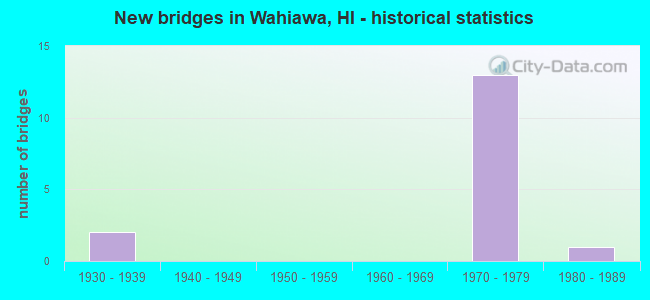
- New bridges - historical statistics
- 21930-1939
- 131970-1979
- 11980-1989


- Bridge Condition - Deck
- 35.7%Good
- 64.3%Satisfactory

- Bridge Condition - Superstructure
- 42.9%Good
- 50.0%Satisfactory
- 7.1%Serious

- Bridge Condition - Substructure
- 50.0%Good
- 50.0%Satisfactory

- Bridge Condition - Culverts
- 50.0%Fair
- 50.0%Poor
Find on map >> Show street view
Structure Number: 3000800300071, Location: 0.18MI N/KILANI AVE (Lat: 21.500878, Lng: -158.029467), Route carried "on" structure: US 80, Year Built: 1932, Status: Open, Structure Length: 6.52m (21.39ft), Average Daily Traffic: 26,100 (year 2017), Truck Traffic: 4%, Average Future Daily Traffic: 27,089 (year 2025), Design Load: H 20, Features Intersected: NF KAUKONAHUA(K THOT), Facility Carried by Structure: KAM HWY
Minimum Vertical Clearance: 4.55m (14.93ft), Kilometerpoint: 1.078, Lanes on structure: 2, Base Highway Network: Yes, Owner: State Highway Agency, Approaching Roadway Width: 10.4m (34.1ft), Material/Design: Steel, Design/Construction: Truss - Thru, Number Of Spans In Main Unit: 1, Length of Maximum Span: 64.0m (210.0ft), Curb or Sidewalk Widths: Left: 2.4m (7.9ft), Right: 2.4m (7.9ft), Curb-To-Curb Width: 7.3m (24.0ft), Out-to-Out Width: 12.2m (40.0ft)
Condition: Deck: Satisfactory, Superstructure: Serious, Substructure: Satisfactory, Channel: Good, Operating Rating: 36.0 metric tons, Method Used To Determine Operating Rating: Load and Resistance Factor Rating (LRFR) rating reported by rating factor(RF) method using HL-93 loadings, Inventory Rating: 27.5 metric tons, Method Used To Determine Inventory Rating: Load and Resistance Factor Rating (LRFR) rating reported by rating factor(RF) method using HL-93 loadings, Structural Evaluation: High priority of corrective action, Deck Geometry: High priority of replacement, Waterway Adequacy: Equal to present desirable criteria, Approach Roadway Alignment: Somewhat better than minimum adequacy, Length Of Structure Improvement: 7.62m (25.00ft), Designated Inspection Frequency: Every 24 months, Critical Feature Inspection Frequency: Every 24 months, Inspection Date: October 2021, Critical Feature Inspection Date: October 2021, Total Project Cost: $6,750,000, Deck Structure Type: Concrete Cast-file-Place
Find on map >> Show street view
Structure Number: 3000800400003, Location: 0.11MI S/AVACADO ST (Lat: 21.492133, Lng: -158.028481), Route carried "on" structure: US 80, Year Built: 1984, Status: Open, Structure Length: 11.28m (37.01ft), Average Daily Traffic: 56,500 (year 2017), Truck Traffic: 4%, Average Future Daily Traffic: 52,480 (year 2025), Design Load: HS 20, Features Intersected: WAHIAWA RSVR(WILSON BR), Facility Carried by Structure: KAM HWY
Minimum Vertical Clearance: 30+ m (98+ ft), Kilometerpoint: 0.048, Lanes on structure: 6, Base Highway Network: Yes, Owner: State Highway Agency, Approaching Roadway Width: 26.2m (86.0ft), Skew: 20 degrees, Material/Design: Prestressed concrete continuous, Design/Construction: Box Beam or Girders - Multiple, Number Of Spans In Main Unit: 3, Length of Maximum Span: 45.7m (149.9ft), Curb or Sidewalk Widths: Left: 0.0m, Right: 1.9m (6.2ft), Curb-To-Curb Width: 23.8m (78.1ft), Out-to-Out Width: 31.7m (104.0ft)
Condition: Deck: Satisfactory, Superstructure: Good, Substructure: Good, Channel: Good, Operating Rating: 41.1 metric tons, Method Used To Determine Operating Rating: Load and Resistance Factor Rating (LRFR) rating reported by rating factor(RF) method using HL-93 loadings, Inventory Rating: 31.8 metric tons, Method Used To Determine Inventory Rating: Load and Resistance Factor Rating (LRFR) rating reported by rating factor(RF) method using HL-93 loadings, Structural Evaluation: Better than present minimum criteria, Deck Geometry: Somewhat better than minimum adequacy, Waterway Adequacy: Equal to present desirable criteria, Approach Roadway Alignment: Equal to present desirable criteria, Designated Inspection Frequency: Every 24 months, Underwater Inspection Frequency: Every 48 months, Inspection Date: October 2021, Underwater Inspection Date: December 2021, Roadway Improvement Cost: $316,000, Total Project Cost: $4,741,000, Deck Structure Type: Concrete Cast-file-Place
Find on map >> Show street view
Structure Number: 3000990300626, Location: 0.18MI N/POAMOHO RD (Lat: 21.518364, Lng: -158.039053), Route carried "on" structure: US 99, Year Built: 1936, Status: Open, Structure Length: 12.34m (40.49ft), Average Daily Traffic: 16,700 (year 2017), Truck Traffic: 3%, Average Future Daily Traffic: 21,960 (year 2025), Design Load: H 15, Features Intersected: UP POAMOHO STRM, Facility Carried by Structure: KAM HWY
Minimum Vertical Clearance: 30+ m (98+ ft), Kilometerpoint: 10.074, Lanes on structure: 2, Base Highway Network: Yes, Owner: State Highway Agency, Approaching Roadway Width: 12.2m (40.0ft), Material/Design: Concrete continuous, Design/Construction: Stringer/Multi-beam, Number Of Spans In Main Unit: 4, Length of Maximum Span: 35.4m (116.1ft), Curb or Sidewalk Widths: Left: 1.5m (4.9ft), Right: 0.0m, Curb-To-Curb Width: 7.4m (24.3ft), Out-to-Out Width: 9.7m (31.8ft)
Condition: Deck: Satisfactory, Superstructure: Satisfactory, Substructure: Satisfactory, Channel: Good, Operating Rating: 35.0 metric tons, Method Used To Determine Operating Rating: Load and Resistance Factor Rating (LRFR) rating reported by rating factor(RF) method using HL-93 loadings, Inventory Rating: 26.9 metric tons, Method Used To Determine Inventory Rating: Load and Resistance Factor Rating (LRFR) rating reported by rating factor(RF) method using HL-93 loadings, Structural Evaluation: Equal to present minimum criteria, Deck Geometry: High priority of replacement, Waterway Adequacy: Better than present minimum criteria, Approach Roadway Alignment: Better than present minimum criteria, Length Of Structure Improvement: 13.26m (43.50ft), Designated Inspection Frequency: Every 24 months, Inspection Date: October 2021, Bridge Improvement Cost: $19,850,000, Total Project Cost: $11,745,000, Deck Structure Type: Concrete Cast-file-Place, Wearing Surface/Protective System: Wearing Surface: Bituminous
Find on map >> Show street view
Structure Number: 3000H20100103, Location: 0.63MI N/URBAN (Lat: 21.414722, Lng: -157.991944), Route carried "on" structure: Interstate H2, Year Built: 1973, Status: Open, Structure Length: 2.07m (6.79ft), Average Daily Traffic: 111,100 (year 2017), Truck Traffic: 2%, Average Future Daily Traffic: 96,680 (year 2025), Design Load: HS 20, Features Intersected: PANAKAUAHI 4-144" CULVT
Minimum Vertical Clearance: 30+ m (98+ ft), Kilometerpoint: 1.658, Lanes on structure: 4, Base Highway Network: Yes, Owner: State Highway Agency, Approaching Roadway Width: 34.1m (111.9ft), Skew: 11 degrees, Material/Design: Steel, Design/Construction: Culvert, Number Of Spans In Main Unit: 4, Length of Maximum Span: 3.7m (12.1ft), Curb-To-Curb Width: 21.3m (69.9ft), Out-to-Out Width: 153.6m (503.9ft)
Condition: Channel: Good, Culverts: Poor, Operating Rating: 89.9 metric tons, Method Used To Determine Operating Rating: Allowable Stress (AS), Inventory Rating: 89.8 metric tons, Method Used To Determine Inventory Rating: Allowable Stress (AS), Structural Evaluation: Meets minimum limits, Deck Geometry: Better than present minimum criteria, Waterway Adequacy: Equal to present desirable criteria, Approach Roadway Alignment: Better than present minimum criteria, Designated Inspection Frequency: Every 24 months, Inspection Date: September 2021, Roadway Improvement Cost: $357,000, Total Project Cost: $5,361,000
Find on map >> Show street view
Structure Number: 3000H20100425, Location: 0.35MI N/PINEAPPLE RD SEP (Lat: 21.458817, Lng: -157.993292), Route carried "on" structure: Interstate H2, Year Built: 1975, Status: Open, Structure Length: 60.66m (199.02ft), Average Daily Traffic: 98,700 (year 2017), Truck Traffic: 3%, Average Future Daily Traffic: 95,102 (year 2025), Design Load: HS 20, Features Intersected: KIPAPA STRM
Minimum Vertical Clearance: 30+ m (98+ ft), Kilometerpoint: 6.840, Lanes on structure: 6, Base Highway Network: Yes, Owner: State Highway Agency, Approaching Roadway Width: 36.0m (118.1ft), Skew: 20 degrees, Material/Design: Prestressed concrete continuous, Design/Construction: Box Beam or Girders - Multiple, Number Of Spans In Main Unit: 8, Number Of Approach Spans: 2, Length of Maximum Span: 76.2m (250.0ft), Curb-To-Curb Width: 33.5m (109.9ft), Out-to-Out Width: 36.0m (118.1ft)
Condition: Deck: Good, Superstructure: Satisfactory, Substructure: Good, Channel: Good, Operating Rating: 53.5 metric tons, Method Used To Determine Operating Rating: Allowable Stress (AS), Inventory Rating: 32.7 metric tons, Method Used To Determine Inventory Rating: Allowable Stress (AS), Structural Evaluation: Equal to present minimum criteria, Deck Geometry: Superior to present desirable criteria, Waterway Adequacy: Better than present minimum criteria, Approach Roadway Alignment: Equal to present desirable criteria, Designated Inspection Frequency: Every 24 months, Inspection Date: October 2021, Deck Structure Type: Concrete Cast-file-Place, Wearing Surface/Protective System: Wearing Surface: Bituminous
Find on map >> Show street view
Structure Number: 3000H20100531, Location: 0.04MI E/MEHEULA SEP (Lat: 21.465375, Lng: -158.002394), Route carried "on" structure: Interstate H2, Year Built: 1975, Status: Open, Structure Length: 0.82m (2.69ft), Average Daily Traffic: 55,400 (year 2017), Truck Traffic: 3%, Average Future Daily Traffic: 71,209 (year 2025), Design Load: HS 20, Features Intersected: 2-132" STRUC.P DRN CULVT
Minimum Vertical Clearance: 30+ m (98+ ft), Kilometerpoint: 8.545, Lanes on structure: 6, Base Highway Network: Yes, Owner: State Highway Agency, Approaching Roadway Width: 48.8m (160.1ft), Skew: 23 degrees, Material/Design: Steel, Design/Construction: Culvert, Number Of Spans In Main Unit: 2, Length of Maximum Span: 3.4m (11.2ft), Curb-To-Curb Width: 36.6m (120.1ft), Out-to-Out Width: 37.2m (122.0ft)
Condition: Culverts: Fair, Operating Rating: 89.9 metric tons, Method Used To Determine Operating Rating: Allowable Stress (AS), Inventory Rating: 89.8 metric tons, Method Used To Determine Inventory Rating: Allowable Stress (AS), Structural Evaluation: Somewhat better than minimum adequacy, Deck Geometry: Superior to present desirable criteria, Waterway Adequacy: Better than present minimum criteria, Approach Roadway Alignment: Better than present minimum criteria, Designated Inspection Frequency: Every 24 months, Inspection Date: September 2021
Find on map >> Show street view
Structure Number: 3000H20100624, Location: 0.97MI N/MEHEULA PKWY BR (Lat: 21.474989, Lng: -158.016547), Route carried "on" structure: Interstate H2, Year Built: 1975, Status: Open, Structure Length: 33.07m (108.50ft), Average Daily Traffic: 71,100 (year 2017), Truck Traffic: 3%, Average Future Daily Traffic: 71,209 (year 2025), Design Load: HS 20, Features Intersected: WAIKAKALAUA STRM
Minimum Vertical Clearance: 30+ m (98+ ft), Kilometerpoint: 10.042, Lanes on structure: 2, Base Highway Network: Yes, Owner: State Highway Agency, Approaching Roadway Width: 13.4m (44.0ft), Skew: 10 degrees, Material/Design: Prestressed concrete continuous, Design/Construction: Box Beam or Girders - Multiple, Number Of Spans In Main Unit: 5, Number Of Approach Spans: 2, Length of Maximum Span: 67.1m (220.1ft), Curb-To-Curb Width: 12.4m (40.7ft), Out-to-Out Width: 13.4m (44.0ft)
Condition: Deck: Satisfactory, Superstructure: Good, Substructure: Good, Channel: Good, Operating Rating: 51.2 metric tons, Method Used To Determine Operating Rating: Load and Resistance Factor Rating (LRFR) rating reported by rating factor(RF) method using HL-93 loadings, Inventory Rating: 23.7 metric tons, Method Used To Determine Inventory Rating: Load and Resistance Factor Rating (LRFR) rating reported by rating factor(RF) method using HL-93 loadings, Structural Evaluation: Somewhat better than minimum adequacy, Deck Geometry: Better than present minimum criteria, Waterway Adequacy: Better than present minimum criteria, Approach Roadway Alignment: Equal to present desirable criteria, Length Of Structure Improvement: 33.07m (108.50ft), Designated Inspection Frequency: Every 24 months, Inspection Date: October 2021, Roadway Improvement Cost: $363,000, Total Project Cost: $5,451,000, Deck Structure Type: Concrete Cast-file-Place
Find on map >> Show street view
Structure Number: 3000H20100625, Location: 0.97MI N/MEHEULA PKWY BR (Lat: 21.474789, Lng: -158.016639), Route carried "on" structure: Interstate H2, Year Built: 1975, Status: Open, Structure Length: 33.07m (108.50ft), Average Daily Traffic: 71,100 (year 2017), Truck Traffic: 3%, Average Future Daily Traffic: 71,209 (year 2025), Design Load: HS 20, Features Intersected: WAIKAKALAUA STRM
Minimum Vertical Clearance: 30+ m (98+ ft), Kilometerpoint: 10.058, Lanes on structure: 2, Base Highway Network: Yes, Owner: State Highway Agency, Approaching Roadway Width: 13.4m (44.0ft), Skew: 10 degrees, Material/Design: Prestressed concrete continuous, Design/Construction: Box Beam or Girders - Multiple, Number Of Spans In Main Unit: 5, Number Of Approach Spans: 2, Length of Maximum Span: 67.1m (220.1ft), Curb-To-Curb Width: 12.4m (40.7ft), Out-to-Out Width: 13.4m (44.0ft)
Condition: Deck: Satisfactory, Superstructure: Good, Substructure: Good, Channel: Good, Operating Rating: 51.2 metric tons, Method Used To Determine Operating Rating: Load and Resistance Factor Rating (LRFR) rating reported by rating factor(RF) method using HL-93 loadings, Inventory Rating: 23.7 metric tons, Method Used To Determine Inventory Rating: Load and Resistance Factor Rating (LRFR) rating reported by rating factor(RF) method using HL-93 loadings, Structural Evaluation: Somewhat better than minimum adequacy, Deck Geometry: Better than present minimum criteria, Waterway Adequacy: Equal to present desirable criteria, Approach Roadway Alignment: Equal to present desirable criteria, Length Of Structure Improvement: 33.07m (108.50ft), Designated Inspection Frequency: Every 24 months, Inspection Date: October 2021, Roadway Improvement Cost: $363,000, Total Project Cost: $5,451,000, Deck Structure Type: Concrete Cast-file-Place
Find on map >> Show street view
Structure Number: 3000H20200745, Location: 0.60MI S/END H2 (Lat: 21.487081, Lng: -158.025947), Route carried "on" structure: Interstate H2, Year Built: 1973, Status: Open, Structure Length: 3.51m (11.52ft), Average Daily Traffic: 60,200 (year 2017), Truck Traffic: 3%, Average Future Daily Traffic: 56,204 (year 2025), Design Load: HS 20, Features Intersected: E RANGE RD WAHIAWA IC #3
Minimum Vertical Clearance: 30+ m (98+ ft), Kilometerpoint: 11.989, Lanes on structure: 3, Lanes under structure: 2, Base Highway Network: Yes, Owner: State Highway Agency, Approaching Roadway Width: 15.2m (49.9ft), Skew: 11 degrees, Material/Design: Concrete, Design/Construction: Box Beam or Girders - Multiple, Number Of Spans In Main Unit: 1, Number Of Approach Spans: 2, Length of Maximum Span: 33.5m (109.9ft), Curb-To-Curb Width: 16.1m (52.8ft), Out-to-Out Width: 17.1m (56.1ft)
Condition: Deck: Satisfactory, Superstructure: Satisfactory, Substructure: Satisfactory, Operating Rating: 56.4 metric tons, Method Used To Determine Operating Rating: Load and Resistance Factor Rating (LRFR) rating reported by rating factor(RF) method using HL-93 loadings, Inventory Rating: 41.8 metric tons, Method Used To Determine Inventory Rating: Load and Resistance Factor Rating (LRFR) rating reported by rating factor(RF) method using HL-93 loadings, Structural Evaluation: Equal to present minimum criteria, Deck Geometry: Equal to present minimum criteria, Underclear: Equal to present minimum criteria, Approach Roadway Alignment: Equal to present desirable criteria, Designated Inspection Frequency: Every 24 months, Inspection Date: September 2021, Deck Structure Type: Concrete Cast-file-Place
Find on map >> Show street view
Structure Number: 3000H20200746, Location: 0.60MI S/END H2 (Lat: 21.487058, Lng: -158.025692), Route carried "on" structure: Interstate H2, Year Built: 1973, Status: Open, Structure Length: 3.51m (11.52ft), Average Daily Traffic: 60,200 (year 2017), Truck Traffic: 3%, Average Future Daily Traffic: 56,204 (year 2025), Design Load: HS 20, Features Intersected: E RANGE RD WAHIAWA IC #4
Minimum Vertical Clearance: 30+ m (98+ ft), Kilometerpoint: 12.005, Lanes on structure: 2, Lanes under structure: 2, Base Highway Network: Yes, Owner: State Highway Agency, Approaching Roadway Width: 11.6m (38.1ft), Skew: 11 degrees, Material/Design: Concrete, Design/Construction: Box Beam or Girders - Multiple, Number Of Spans In Main Unit: 1, Number Of Approach Spans: 2, Length of Maximum Span: 33.5m (109.9ft), Curb-To-Curb Width: 12.2m (40.0ft), Out-to-Out Width: 13.4m (44.0ft)
Condition: Deck: Satisfactory, Superstructure: Satisfactory, Substructure: Satisfactory, Operating Rating: 66.4 metric tons, Method Used To Determine Operating Rating: Load and Resistance Factor Rating (LRFR) rating reported by rating factor(RF) method using HL-93 loadings, Inventory Rating: 49.2 metric tons, Method Used To Determine Inventory Rating: Load and Resistance Factor Rating (LRFR) rating reported by rating factor(RF) method using HL-93 loadings, Structural Evaluation: Equal to present minimum criteria, Deck Geometry: Better than present minimum criteria, Underclear: Equal to present minimum criteria, Approach Roadway Alignment: Equal to present desirable criteria, Designated Inspection Frequency: Every 24 months, Inspection Date: September 2021, Deck Structure Type: Concrete Cast-file-Place
Find on map >> Show street view
Structure Number: 3000H20200771, Location: 0.35MI S/END H2 (Lat: 21.489672, Lng: -158.028378), Route carried "on" structure: Interstate H2, Year Built: 1973, Status: Open, Structure Length: 6.64m (21.78ft), Average Daily Traffic: 59,900 (year 2017), Truck Traffic: 3%, Average Future Daily Traffic: 33,194 (year 2025), Design Load: HS 20, Features Intersected: KAM HWY-WAHIAWA IC #1
Minimum Vertical Clearance: 30+ m (98+ ft), Kilometerpoint: 12.408, Lanes on structure: 3, Lanes under structure: 4, Base Highway Network: Yes, Owner: State Highway Agency, Approaching Roadway Width: 18.3m (60.0ft), Skew: 13 degrees, Material/Design: Concrete continuous, Design/Construction: Box Beam or Girders - Multiple, Number Of Spans In Main Unit: 2, Number Of Approach Spans: 2, Length of Maximum Span: 33.2m (108.9ft), Curb-To-Curb Width: 16.3m (53.5ft), Out-to-Out Width: 17.1m (56.1ft)
Condition: Deck: Satisfactory, Superstructure: Satisfactory, Substructure: Satisfactory, Operating Rating: 46.3 metric tons, Method Used To Determine Operating Rating: Load and Resistance Factor Rating (LRFR) rating reported by rating factor(RF) method using HL-93 loadings, Inventory Rating: 36.0 metric tons, Method Used To Determine Inventory Rating: Load and Resistance Factor Rating (LRFR) rating reported by rating factor(RF) method using HL-93 loadings, Structural Evaluation: Equal to present minimum criteria, Deck Geometry: Equal to present minimum criteria, Underclear: Somewhat better than minimum adequacy, Approach Roadway Alignment: Better than present minimum criteria, Designated Inspection Frequency: Every 24 months, Inspection Date: September 2021, Deck Structure Type: Concrete Cast-file-Place
Find on map >> Show street view
Structure Number: 3000H20200772, Location: 0.35MI S/END H2 (Lat: 21.489900, Lng: -158.028383), Route carried "on" structure: Interstate H2, Year Built: 1974, Status: Open, Structure Length: 8.96m (29.40ft), Average Daily Traffic: 59,900 (year 2017), Truck Traffic: 3%, Average Future Daily Traffic: 33,194 (year 2025), Design Load: HS 20, Features Intersected: KAM HWY-WAHIAWA IC #2
Minimum Vertical Clearance: 30+ m (98+ ft), Kilometerpoint: 12.424, Lanes on structure: 2, Lanes under structure: 4, Base Highway Network: Yes, Owner: State Highway Agency, Approaching Roadway Width: 13.4m (44.0ft), Skew: 13 degrees, Material/Design: Concrete continuous, Design/Construction: Box Beam or Girders - Multiple, Number Of Spans In Main Unit: 2, Number Of Approach Spans: 2, Length of Maximum Span: 32.6m (107.0ft), Curb-To-Curb Width: 12.6m (41.3ft), Out-to-Out Width: 13.4m (44.0ft)
Condition: Deck: Good, Superstructure: Good, Substructure: Satisfactory, Operating Rating: 29.2 metric tons, Method Used To Determine Operating Rating: Load and Resistance Factor Rating (LRFR) rating reported by rating factor(RF) method using HL-93 loadings, Inventory Rating: 18.8 metric tons, Method Used To Determine Inventory Rating: Load and Resistance Factor Rating (LRFR) rating reported by rating factor(RF) method using HL-93 loadings, Structural Evaluation: Meets minimum limits, Deck Geometry: Better than present minimum criteria, Underclear: Somewhat better than minimum adequacy, Approach Roadway Alignment: Equal to present desirable criteria, Designated Inspection Frequency: Every 24 months, Inspection Date: September 2021, Deck Structure Type: Concrete Cast-file-Place
Find on map >> Show street view
Structure Number: 3000H21100392, Location: 1.67MI N/MILILANI ACC RD (Lat: 21.451881, Lng: -157.990097), Route carried "on" structure: Other road H2, Year Built: 1973, Status: Open, Structure Length: 5.49m (18.01ft), Average Daily Traffic: 98,700 (year 2017), Truck Traffic: 3%, Average Future Daily Traffic: 95,102 (year 2025), Design Load: HS 20, Features Intersected: FAI-H2(PINEAPPLE RD), Facility Carried by Structure: PINEAPPLE RD
Minimum Vertical Clearance: 5.26m (17.26ft), Kilometerpoint: 6.308, Lanes on structure: 2, Lanes under structure: 6, Owner: State Highway Agency, Approaching Roadway Width: 35.1m (115.2ft), Material/Design: Concrete continuous, Design/Construction: Box Beam or Girders - Multiple, Number Of Spans In Main Unit: 2, Length of Maximum Span: 27.4m (89.9ft), Curb-To-Curb Width: 8.0m (26.2ft), Out-to-Out Width: 9.0m (29.5ft)
Condition: Deck: Good, Superstructure: Good, Substructure: Good, Operating Rating: 51.2 metric tons, Method Used To Determine Operating Rating: Load and Resistance Factor Rating (LRFR) rating reported by rating factor(RF) method using HL-93 loadings, Inventory Rating: 39.5 metric tons, Method Used To Determine Inventory Rating: Load and Resistance Factor Rating (LRFR) rating reported by rating factor(RF) method using HL-93 loadings, Structural Evaluation: Better than present minimum criteria, Deck Geometry: High priority of replacement, Underclear: Somewhat better than minimum adequacy, Approach Roadway Alignment: Equal to present desirable criteria, Designated Inspection Frequency: Every 24 months, Inspection Date: September 2021, Roadway Improvement Cost: $52,000, Total Project Cost: $786,000, Deck Structure Type: Concrete Cast-file-Place
Find on map >> Show street view
Structure Number: 3000H21100698, Location: 0.76MI N/WAIKAKALAUA STRM (Lat: 21.480158, Lng: -158.024425), Route carried "on" structure: Other road H2, Year Built: 1973, Status: Open, Structure Length: 6.10m (20.01ft), Average Daily Traffic: 60,200 (year 2017), Truck Traffic: 3%, Average Future Daily Traffic: 63,666 (year 2025), Design Load: HS 20, Features Intersected: FAI-H2(GOLF COURSE RD), Facility Carried by Structure: GOLF COUSE RD)
Minimum Vertical Clearance: 5.27m (17.29ft), Kilometerpoint: 11.233, Lanes on structure: 2, Lanes under structure: 5, Owner: State Highway Agency, Approaching Roadway Width: 18.9m (62.0ft), Material/Design: Concrete continuous, Design/Construction: Box Beam or Girders - Multiple, Number Of Spans In Main Unit: 2, Length of Maximum Span: 35.1m (115.2ft), Curb-To-Curb Width: 13.4m (44.0ft), Out-to-Out Width: 14.0m (45.9ft)
Condition: Deck: Good, Superstructure: Good, Substructure: Good, Operating Rating: 72.9 metric tons, Method Used To Determine Operating Rating: Load and Resistance Factor Rating (LRFR) rating reported by rating factor(RF) method using HL-93 loadings, Inventory Rating: 56.1 metric tons, Method Used To Determine Inventory Rating: Load and Resistance Factor Rating (LRFR) rating reported by rating factor(RF) method using HL-93 loadings, Structural Evaluation: Better than present minimum criteria, Deck Geometry: Equal to present minimum criteria, Underclear: Somewhat better than minimum adequacy, Approach Roadway Alignment: Equal to present desirable criteria, Designated Inspection Frequency: Every 24 months, Inspection Date: September 2021, Deck Structure Type: Concrete Cast-file-Place
Find on map >> Show street view
Structure Number: 3000H21200223, Location: 1.85MI N/URBAN BOUNDARY (Lat: 21.428900, Lng: -157.996419), Route carried "on" structure: City street H2, Year Built: 1972, Status: Open, Structure Length: 5.49m (18.01ft), Average Daily Traffic: 83,500 (year 2017), Truck Traffic: 3%, Average Future Daily Traffic: 95,102 (year 2025), Design Load: HS 20, Features Intersected: FAI-H2(MILILANI ACC RD), Facility Carried by Structure: MILILANI MEM PK RD
Minimum Vertical Clearance: 5.13m (16.83ft), Kilometerpoint: 3.589, Lanes on structure: 2, Lanes under structure: 4, Owner: State Highway Agency, Approaching Roadway Width: 37.8m (124.0ft), Material/Design: Concrete continuous, Design/Construction: Box Beam or Girders - Multiple, Number Of Spans In Main Unit: 2, Length of Maximum Span: 27.4m (89.9ft), Curb-To-Curb Width: 19.3m (63.3ft), Out-to-Out Width: 20.6m (67.6ft)
Condition: Deck: Good, Superstructure: Satisfactory, Substructure: Good, Operating Rating: 32.7 metric tons, Method Used To Determine Operating Rating: Load and Resistance Factor Rating (LRFR) rating reported by rating factor(RF) method using HL-93 loadings, Inventory Rating: 25.3 metric tons, Method Used To Determine Inventory Rating: Load and Resistance Factor Rating (LRFR) rating reported by rating factor(RF) method using HL-93 loadings, Structural Evaluation: Equal to present minimum criteria, Deck Geometry: Superior to present desirable criteria, Underclear: Superior to present desirable criteria, Approach Roadway Alignment: Equal to present desirable criteria, Designated Inspection Frequency: Every 24 months, Inspection Date: September 2021, Deck Structure Type: Concrete Cast-file-Place
Find on map >> Show street view
Structure Number: 3000H21200527, Location: 1.03MI N/KIPAPA STRM BR (Lat: 21.465311, Lng: -158.003975), Route carried "on" structure: City street H2, Year Built: 1973, Status: Open, Structure Length: 6.46m (21.19ft), Average Daily Traffic: 55,400 (year 2017), Truck Traffic: 3%, Average Future Daily Traffic: 71,209 (year 2025), Design Load: HS 20, Features Intersected: FAI-H2(MEHEULA PKWY RD), Facility Carried by Structure: MEHEULA PKWY RD
Minimum Vertical Clearance: 6.40m (21.00ft), Kilometerpoint: 8.481, Lanes on structure: 4, Lanes under structure: 5, Owner: State Highway Agency, Approaching Roadway Width: 25.6m (84.0ft), Skew: 20 degrees, Material/Design: Concrete continuous, Design/Construction: Box Beam or Girders - Multiple, Number Of Spans In Main Unit: 2, Length of Maximum Span: 36.6m (120.1ft), Curb or Sidewalk Widths: Left: 2.4m (7.9ft), Right: 2.4m (7.9ft), Curb-To-Curb Width: 23.2m (76.1ft), Out-to-Out Width: 28.7m (94.2ft)
Condition: Deck: Satisfactory, Superstructure: Satisfactory, Substructure: Satisfactory, Operating Rating: 61.2 metric tons, Method Used To Determine Operating Rating: Load and Resistance Factor Rating (LRFR) rating reported by rating factor(RF) method using HL-93 loadings, Inventory Rating: 47.3 metric tons, Method Used To Determine Inventory Rating: Load and Resistance Factor Rating (LRFR) rating reported by rating factor(RF) method using HL-93 loadings, Structural Evaluation: Equal to present minimum criteria, Deck Geometry: Superior to present desirable criteria, Underclear: Superior to present desirable criteria, Approach Roadway Alignment: Equal to present desirable criteria, Designated Inspection Frequency: Every 24 months, Inspection Date: September 2021, Deck Structure Type: Concrete Cast-file-Place