Bridge Statistics for Tyre, New York (NY)
Condition, Traffic, Stress, Structural Evaluation, Project Costs
- National Bridge Inventory (NBI) Statistics
- 24Number of bridges
- 538ft / 164mTotal length
- $98,457,000Total costs
- 211,715Total average daily traffic
- 28,196Total average daily truck traffic
- National Bridge Inventory (NBI) Registered Bridges for Tyre
- No street view available for this location
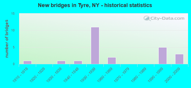
- New bridges - historical statistics
- 11910-1919
- 11930-1939
- 11940-1949
- 111950-1959
- 21960-1969
- 51990-1999
- 32000-2009

- Reconstructed bridges - Historical Statistics
- 11960-1969
- 01970-1979
- 21980-1989
- 01990-1999
- 02000-2009
- 22010-2019


- Bridge Condition - Deck
- 6.7%Very good
- 40.0%Good
- 20.0%Satisfactory
- 20.0%Fair
- 13.3%Poor

- Bridge Condition - Superstructure
- 18.8%Very good
- 18.8%Good
- 6.3%Satisfactory
- 43.8%Fair
- 12.5%Poor

- Bridge Condition - Substructure
- 18.8%Very good
- 31.3%Good
- 18.8%Satisfactory
- 18.8%Fair
- 12.5%Poor

- Bridge Condition - Channel
- 16.7%Very good
- 58.3%Good
- 25.0%Satisfactory

- Bridge Condition - Culverts
- 50.0%Good
- 50.0%Fair
Find on map >> Show street view
Structure Number: 102179, Location: .8 MI SE JCT SH31&WYNE CL (Lat: 43.020300, Lng: -76.728800), Route carried "on" structure: State highway 31, Year Built: 1997, Status: Open, Structure Length: 0.76m (2.49ft), Average Daily Traffic: 1,692 (year 2018), Truck Traffic: 14%, Average Future Daily Traffic: 1,702 (year 2040), Design Load: HS 25 or greater, Features Intersected: TRIB SENECA RIVER
Minimum Vertical Clearance: 30+ m (98+ ft), Kilometerpoint: 1.287, Lanes on structure: 2, Base Highway Network: Yes, Owner: State Highway Agency, Approaching Roadway Width: 9.8m (32.2ft), Skew: 3 degrees, Material/Design: Concrete, Design/Construction: Culvert, Number Of Spans In Main Unit: 1, Length of Maximum Span: 7.3m (24.0ft)
Condition: Channel: Satisfactory, Culverts: Good, Operating Rating: 89.8 metric tons, Method Used To Determine Operating Rating: Load Factor (LF), Inventory Rating: 73.5 metric tons, Method Used To Determine Inventory Rating: Load Factor (LF), Structural Evaluation: Better than present minimum criteria, Waterway Adequacy: Equal to present minimum criteria, Approach Roadway Alignment: Equal to present desirable criteria, Length Of Structure Improvement: 0.76m (2.49ft), Designated Inspection Frequency: Every 24 months, Inspection Date: August 2021, Bridge Improvement Cost: $616,000, Roadway Improvement Cost: $361,000, Total Project Cost: $977,000 ( Estimate for 2021)
Find on map >> Show street view
Structure Number: 103432, Location: JCT OF RTS 89 + I-90 (Lat: 42.985925, Lng: -76.769989), Route carried "on" structure: State highway 89, Year Built: 1953, Year Reconstructed: 1972, Status: Open, Structure Length: 6.58m (21.59ft), Average Daily Traffic: 1,155 (year 2020), Truck Traffic: 11%, Average Future Daily Traffic: 1,614 (year 2040), Design Load: HS 20+Mod, Features Intersected: 90IX EB, RTE I90
Minimum Vertical Clearance: 30+ m (98+ ft), Kilometerpoint: 54.416, Lanes on structure: 2, Lanes under structure: 4, Base Highway Network: Yes, Owner: State Toll Authority, Approaching Roadway Width: 10.4m (34.1ft), Skew: 1 degrees, Material/Design: Steel, Design/Construction: Stringer/Multi-beam, Number Of Spans In Main Unit: 4, Length of Maximum Span: 19.8m (65.0ft), Curb-To-Curb Width: 9.1m (29.9ft), Out-to-Out Width: 10.1m (33.1ft)
Condition: Deck: Fair, Superstructure: Fair, Substructure: Poor, Operating Rating: 70.8 metric tons, Method Used To Determine Operating Rating: Load Factor (LF), Inventory Rating: 39.0 metric tons, Method Used To Determine Inventory Rating: Load Factor (LF), Structural Evaluation: Meets minimum limits, Deck Geometry: Somewhat better than minimum adequacy, Underclear: High priority of corrective action, Approach Roadway Alignment: Equal to present desirable criteria, Length Of Structure Improvement: 6.58m (21.59ft), Designated Inspection Frequency: Every 24 months, Inspection Date: October 2021, Bridge Improvement Cost: $1,519,000, Roadway Improvement Cost: $890,000, Total Project Cost: $2,409,000 ( Estimate for 2021), Deck Structure Type: Concrete Cast-file-Place, Wearing Surface/Protective System: Wearing Surface: Integral Concrete
Find on map >> Show street view
Structure Number: 104815, Location: JCT SH 414 & I90 (Lat: 42.967603, Lng: -76.847278), Route carried "on" structure: State highway 414, Year Built: 2000, Year Reconstructed: 2016, Status: Open, Structure Length: 7.13m (23.39ft), Average Daily Traffic: 8,127 (year 2020), Truck Traffic: 19%, Average Future Daily Traffic: 8,177 (year 2040), Design Load: HS 25 or greater, Features Intersected: 90IX EB, RTE I90
Minimum Vertical Clearance: 30+ m (98+ ft), Kilometerpoint: 53.338, Lanes on structure: 4, Lanes under structure: 6, Base Highway Network: Yes, Owner: State Toll Authority, Approaching Roadway Width: 19.5m (64.0ft), Material/Design: Steel continuous, Design/Construction: Stringer/Multi-beam, Number Of Spans In Main Unit: 2, Length of Maximum Span: 35.1m (115.2ft), Curb-To-Curb Width: 19.5m (64.0ft), Out-to-Out Width: 20.4m (66.9ft)
Condition: Deck: Good, Superstructure: Very good, Substructure: Very good, Operating Rating: 94.3 metric tons, Method Used To Determine Operating Rating: Load Factor (LF), Inventory Rating: 56.2 metric tons, Method Used To Determine Inventory Rating: Load Factor (LF), Structural Evaluation: Equal to present desirable criteria, Deck Geometry: Better than present minimum criteria, Underclear: High priority of corrective action, Approach Roadway Alignment: Equal to present desirable criteria, Length Of Structure Improvement: 7.13m (23.39ft), Designated Inspection Frequency: Every 24 months, Inspection Date: November 2020, Bridge Improvement Cost: $3,267,000, Roadway Improvement Cost: $1,913,000, Total Project Cost: $5,180,000 ( Estimate for 2021), Deck Structure Type: Concrete Cast-file-Place, Wearing Surface/Protective System: Wearing Surface: Integral Concrete, Deck Protection: Galvanized Reinforcing
Find on map >> Show street view
Structure Number: 107434, Location: Black Brook (Lat: 42.952989, Lng: -76.809525), Route carried "on" structure: State highway 318, Year Built: 1962, Status: Open, Structure Length: 0.91m (2.99ft), Average Daily Traffic: 7,720 (year 2017), Truck Traffic: 10%, Average Future Daily Traffic: 10,793 (year 2040), Design Load: H 20, Features Intersected: Black Brook
Minimum Vertical Clearance: 30+ m (98+ ft), Kilometerpoint: 12.952, Lanes on structure: 2, Base Highway Network: Yes, Owner: State Highway Agency, Approaching Roadway Width: 7.3m (24.0ft), Skew: 3 degrees, Material/Design: Aluminum, Iron, Design/Construction: Culvert, Number Of Spans In Main Unit: 2, Length of Maximum Span: 3.7m (12.1ft)
Condition: Channel: Satisfactory, Culverts: Fair, Operating Rating: 72.5 metric tons, Method Used To Determine Operating Rating: Field evaluation and documented engineering judgment, Inventory Rating: 32.7 metric tons, Method Used To Determine Inventory Rating: Field evaluation and documented engineering judgment, Structural Evaluation: Somewhat better than minimum adequacy, Waterway Adequacy: Meets minimum limits, Approach Roadway Alignment: Equal to present desirable criteria, Length Of Structure Improvement: 0.91m (2.99ft), Designated Inspection Frequency: Every 24 months, Inspection Date: September 2021, Bridge Improvement Cost: $155,000, Roadway Improvement Cost: $91,000, Total Project Cost: $246,000 ( Estimate for 2021)
Find on map >> Show street view
Structure Number: 331399, Location: 4.6 MI N OF SENECA FALLS (Lat: 42.991839, Lng: -76.803258), Route carried "on" structure: County highway , Year Built: 1950, Status: Open, Structure Length: 1.16m (3.81ft), Average Daily Traffic: 321 (year 2019), Truck Traffic: 8%, Average Future Daily Traffic: 449 (year 2039), Features Intersected: BLACK BROOK, Facility Carried by Structure: CR 101
Minimum Vertical Clearance: 30+ m (98+ ft), Kilometerpoint: 7.578, Lanes on structure: 2, Owner: County Highway Agency, Approaching Roadway Width: 4.9m (16.1ft), Material/Design: Concrete, Number Of Spans In Main Unit: 1, Length of Maximum Span: 10.6m (34.8ft), Curb or Sidewalk Widths: Left: 1.0m (3.3ft), Right: 0.1m (0.3ft), Curb-To-Curb Width: 6.0m (19.7ft), Out-to-Out Width: 7.3m (24.0ft)
Condition: Deck: Good, Superstructure: Good, Substructure: Good, Channel: Good, Operating Rating: 63.1 metric tons, Method Used To Determine Operating Rating: Field evaluation and documented engineering judgment, Inventory Rating: 26.8 metric tons, Method Used To Determine Inventory Rating: Field evaluation and documented engineering judgment, Structural Evaluation: Equal to present minimum criteria, Deck Geometry: High priority of corrective action, Waterway Adequacy: Meets minimum limits, Approach Roadway Alignment: Meets minimum limits, Length Of Structure Improvement: 1.15m (3.77ft), Designated Inspection Frequency: Every 24 months, Inspection Date: August 2020, Bridge Improvement Cost: $218,000, Roadway Improvement Cost: $128,000, Total Project Cost: $346,000 ( Estimate for 2021), Wearing Surface/Protective System: Wearing Surface: Bituminous
Find on map >> Show street view
Structure Number: 336155, Location: 6.5 MI N OF SENECA FALLS (Lat: 42.997006, Lng: -76.761631), Route carried "on" structure: County highway , Year Built: 2003, Status: Open, Structure Length: 7.83m (25.69ft), Average Daily Traffic: 93 (year 2017), Truck Traffic: 8%, Average Future Daily Traffic: 130 (year 2037), Design Load: HS 25 or greater, Features Intersected: CLYDE RIVER, Facility Carried by Structure: MAYS POINT RD
Minimum Vertical Clearance: 30+ m (98+ ft), Kilometerpoint: 0.434, Lanes on structure: 2, Owner: County Highway Agency, Approaching Roadway Width: 6.7m (22.0ft), Skew: 2 degrees, Material/Design: Prestressed concrete, Design/Construction: Box Beam or Girders - Multiple, Number Of Spans In Main Unit: 3, Length of Maximum Span: 25.0m (82.0ft), Curb-To-Curb Width: 6.6m (21.7ft), Out-to-Out Width: 7.6m (24.9ft)
Condition: Deck: Good, Superstructure: Good, Substructure: Good, Channel: Good, Operating Rating: 73.5 metric tons, Method Used To Determine Operating Rating: Load Factor (LF), Inventory Rating: 43.5 metric tons, Method Used To Determine Inventory Rating: Load Factor (LF), Structural Evaluation: Better than present minimum criteria, Deck Geometry: Somewhat better than minimum adequacy, Waterway Adequacy: Equal to present minimum criteria, Approach Roadway Alignment: Equal to present minimum criteria, Length Of Structure Improvement: 7.83m (25.69ft), Designated Inspection Frequency: Every 24 months, Underwater Inspection Frequency: Every 60 months, Inspection Date: July 2021, Underwater Inspection Date: June 2018, Bridge Improvement Cost: $1,633,000, Roadway Improvement Cost: $956,000, Total Project Cost: $2,589,000 ( Estimate for 2021), Wearing Surface/Protective System: Wearing Surface: Monolithic Concrete
Find on map >> Show street view
Structure Number: 400197, Location: JCT US 20 & CAY & SEN CNL (Lat: 42.962961, Lng: -76.738342), Route carried "on" structure: State highway 5, Year Built: 1932, Status: Open, Structure Length: 9.60m (31.50ft), Average Daily Traffic: 10,242 (year 2018), Truck Traffic: 12%, Average Future Daily Traffic: 10,590 (year 2040), Design Load: H 20, Features Intersected: CAY & SEN CANAL
Minimum Vertical Clearance: 4.42m (14.50ft), Kilometerpoint: 23.009, Lanes on structure: 2, Base Highway Network: Yes, Owner: State Highway Agency, Approaching Roadway Width: 12.2m (40.0ft), Navigation Control: Yes ( Vertical Clearance: 4.5m (14.8ft), Horizontal Clearance: 36.5m (119.8ft)), Material/Design: Steel, Design/Construction: Truss - Thru, Number Of Spans In Main Unit: 1, Number Of Approach Spans: 2, Length of Maximum Span: 38.1m (125.0ft), Curb or Sidewalk Widths: Left: 1.5m (4.9ft), Right: 0.0m, Curb-To-Curb Width: 12.2m (40.0ft), Out-to-Out Width: 13.3m (43.6ft)
Condition: Deck: Satisfactory, Superstructure: Fair, Substructure: Fair, Channel: Good, Operating Rating: 40.8 metric tons, Method Used To Determine Operating Rating: Load Factor (LF), Inventory Rating: 24.5 metric tons, Method Used To Determine Inventory Rating: Load Factor (LF), Structural Evaluation: Somewhat better than minimum adequacy, Deck Geometry: Somewhat better than minimum adequacy, Waterway Adequacy: Superior to present desirable criteria, Approach Roadway Alignment: Equal to present desirable criteria, Length Of Structure Improvement: 9.60m (31.50ft), Designated Inspection Frequency: Every 24 months, Critical Feature Inspection Frequency: Every 12 months, Underwater Inspection Frequency: Every 60 months, Inspection Date: April 2021, Critical Feature Inspection Date: April 2021, Underwater Inspection Date: July 2017, Bridge Improvement Cost: $9,651,000, Roadway Improvement Cost: $5,652,000, Total Project Cost: $15,303,000 ( Estimate for 2021), Deck Structure Type: Concrete Cast-file-Place, Wearing Surface/Protective System: Wearing Surface: Latex Concrete
Find on map >> Show street view
Structure Number: 40218, Location: JCT SH 31 & CAY & SEN CNL (Lat: 43.017464, Lng: -76.712008), Route carried "on" structure: State highway 31, Year Built: 1949, Status: Open, Structure Length: 15.30m (50.20ft), Average Daily Traffic: 1,688 (year 2020), Truck Traffic: 13%, Average Future Daily Traffic: 1,698 (year 2040), Design Load: H 20, Features Intersected: ERIE CANAL/SENECA RIVER
Minimum Vertical Clearance: 4.54m (14.90ft), Kilometerpoint: 0.000, Lanes on structure: 2, Base Highway Network: Yes, Owner: State Highway Agency, Approaching Roadway Width: 10.4m (34.1ft), Navigation Control: Yes ( Vertical Clearance: 6.0m (19.7ft), Horizontal Clearance: 45.7m (149.9ft)), Material/Design: Steel, Design/Construction: Truss - Thru, Number Of Spans In Main Unit: 1, Number Of Approach Spans: 4, Length of Maximum Span: 76.2m (250.0ft), Curb or Sidewalk Widths: Left: 0.3m (1.0ft), Right: 0.3m (1.0ft), Curb-To-Curb Width: 9.4m (30.8ft), Out-to-Out Width: 10.9m (35.8ft)
Condition: Deck: Satisfactory, Superstructure: Fair, Substructure: Poor, Channel: Good, Operating Rating: 55.3 metric tons, Method Used To Determine Operating Rating: Load Factor (LF), Inventory Rating: 32.7 metric tons, Method Used To Determine Inventory Rating: Load Factor (LF), Structural Evaluation: Meets minimum limits, Deck Geometry: Somewhat better than minimum adequacy, Waterway Adequacy: Superior to present desirable criteria, Approach Roadway Alignment: Equal to present desirable criteria, Length Of Structure Improvement: 15.30m (50.20ft), Designated Inspection Frequency: Every 24 months, Critical Feature Inspection Frequency: Every 12 months, Underwater Inspection Frequency: Every 60 months, Inspection Date: October 2021, Critical Feature Inspection Date: October 2021, Underwater Inspection Date: May 2021, Bridge Improvement Cost: $10,397,000, Roadway Improvement Cost: $6,089,000, Total Project Cost: $16,486,000 ( Estimate for 2021), Deck Structure Type: Concrete Cast-file-Place, Wearing Surface/Protective System: Wearing Surface: Monolithic Concrete
Find on map >> Show street view
Structure Number: 406041, Location: .8 MI NE JCT SH 89 & I90 (Lat: 42.999325, Lng: -76.764150), Route carried "on" structure: State highway 89, Year Built: 1969, Year Reconstructed: 2015, Status: Open, Structure Length: 38.86m (127.49ft), Average Daily Traffic: 1,155 (year 2020), Truck Traffic: 11%, Average Future Daily Traffic: 1,614 (year 2040), Design Load: H 20, Features Intersected: ERIE CANAL, CLYDE RIVER
Minimum Vertical Clearance: 30+ m (98+ ft), Kilometerpoint: 55.720, Lanes on structure: 2, Base Highway Network: Yes, Owner: State Highway Agency, Approaching Roadway Width: 14.3m (46.9ft), Navigation Control: Yes ( Vertical Clearance: 6.7m (22.0ft), Horizontal Clearance: 39.9m (130.9ft)), Material/Design: Steel, Design/Construction: Stringer/Multi-beam, Number Of Spans In Main Unit: 11, Length of Maximum Span: 48.1m (157.8ft), Curb-To-Curb Width: 10.7m (35.1ft), Out-to-Out Width: 11.6m (38.1ft)
Condition: Deck: Good, Superstructure: Fair, Substructure: Good, Channel: Very good, Operating Rating: 54.4 metric tons, Method Used To Determine Operating Rating: Load Factor (LF), Inventory Rating: 32.7 metric tons, Method Used To Determine Inventory Rating: Load Factor (LF), Structural Evaluation: Somewhat better than minimum adequacy, Deck Geometry: Equal to present minimum criteria, Waterway Adequacy: Superior to present desirable criteria, Approach Roadway Alignment: Equal to present desirable criteria, Length Of Structure Improvement: 38.86m (127.49ft), Designated Inspection Frequency: Every 24 months, Underwater Inspection Frequency: Every 60 months, Inspection Date: October 2020, Underwater Inspection Date: August 2017, Bridge Improvement Cost: $8,422,000, Roadway Improvement Cost: $4,932,000, Total Project Cost: $13,354,000 ( Estimate for 2021), Deck Structure Type: Concrete Cast-file-Place, Wearing Surface/Protective System: Wearing Surface: Epoxy Overlay
Find on map >> Show street view
Structure Number: 443501, Location: 2.3 MI NW JCT SH 89 & CNL (Lat: 43.020639, Lng: -76.798889), Route carried "on" structure: County highway , Year Built: 1914, Status: Posted for load, Structure Length: 9.39m (30.81ft), Average Daily Traffic: 244 (year 2018), Truck Traffic: 3%, Average Future Daily Traffic: 342 (year 2038), Features Intersected: ERIE CANAL/CLYDE RIVER, Facility Carried by Structure: ARMITAGE ROAD
Minimum Vertical Clearance: 2.74m (8.99ft), Kilometerpoint: 1.158, Lanes on structure: 1, Owner: State Highway Agency, Approaching Roadway Width: 5.8m (19.0ft), Navigation Control: Yes ( Vertical Clearance: 4.8m (15.7ft), Horizontal Clearance: 53.3m (174.9ft)), Material/Design: Steel, Design/Construction: Truss - Thru, Number Of Spans In Main Unit: 1, Number Of Approach Spans: 2, Length of Maximum Span: 55.1m (180.8ft), Curb-To-Curb Width: 4.5m (14.8ft), Out-to-Out Width: 5.3m (17.4ft)
Condition: Deck: Poor, Superstructure: Poor, Substructure: Fair, Channel: Very good, Operating Rating: 10.9 metric tons, Method Used To Determine Operating Rating: Load Factor (LF), Inventory Rating: 6.4 metric tons, Method Used To Determine Inventory Rating: Load Factor (LF), Structural Evaluation: High priority of corrective action, Deck Geometry: High priority of replacement, Waterway Adequacy: Equal to present desirable criteria, Approach Roadway Alignment: High priority of replacement, Bridge Posting: Required (Relationship of Operating Rating to Maximum Legal Load: > 39.9% below), Length Of Structure Improvement: 9.38m (30.77ft), Designated Inspection Frequency: Every 12 months, Critical Feature Inspection Frequency: Every 12 months, Underwater Inspection Frequency: Every 60 months, Inspection Date: October 2021, Critical Feature Inspection Date: October 2021, Underwater Inspection Date: November 2017, Bridge Improvement Cost: $3,552,000, Roadway Improvement Cost: $2,080,000, Total Project Cost: $5,632,000 ( Estimate for 2021), Deck Structure Type: Open Grating, Wearing Surface/Protective System: Wearing Surface: Other
Find on map >> Show street view
Structure Number: 4435021, Location: JCT I-90 WB/Seneca River (Lat: 42.997781, Lng: -76.731436), Route carried "on" structure: Interstate 90, Year Built: 1953, Year Reconstructed: 1994, Status: Open, Structure Length: 19.05m (62.50ft), Average Daily Traffic: 16,708 (year 2014), Truck Traffic: 18%, Design Load: HS 20+Mod, Features Intersected: CAYUGA-SENECA CANAL
Minimum Vertical Clearance: 30+ m (98+ ft), Kilometerpoint: 504.936, Lanes on structure: 2, Base Highway Network: Yes, Toll: On Interstate toll segment, Owner: State Toll Authority, Approaching Roadway Width: 11.3m (37.1ft), Skew: 2 degrees, Navigation Control: Yes ( Vertical Clearance: 6.1m (20.0ft), Horizontal Clearance: 82.3m (270.0ft)), Material/Design: Steel, Design/Construction: Girder and Floorbeam System, Number Of Spans In Main Unit: 3, Length of Maximum Span: 82.2m (269.7ft), Curb-To-Curb Width: 16.1m (52.8ft), Out-to-Out Width: 17.1m (56.1ft)
Condition: Deck: Good, Superstructure: Good, Substructure: Good, Channel: Good, Operating Rating: 44.5 metric tons, Method Used To Determine Operating Rating: Load Factor (LF), Inventory Rating: 27.2 metric tons, Method Used To Determine Inventory Rating: Load Factor (LF), Structural Evaluation: Equal to present minimum criteria, Deck Geometry: Superior to present desirable criteria, Waterway Adequacy: Equal to present minimum criteria, Approach Roadway Alignment: Equal to present desirable criteria, Length Of Structure Improvement: 19.05m (62.50ft), Designated Inspection Frequency: Every 24 months, Critical Feature Inspection Frequency: Every 24 months, Inspection Date: April 2020, Critical Feature Inspection Date: April 2020, Bridge Improvement Cost: $6,557,000, Roadway Improvement Cost: $3,840,000, Total Project Cost: $10,396,000 ( Estimate for 2021), Deck Structure Type: Concrete Cast-file-Place, Wearing Surface/Protective System: Wearing Surface: Bituminous, Membrane: Other, Deck Protection: Epoxy Coated Reinforcing
Find on map >> Show street view
Structure Number: 4435022, Location: JCT I90EB/CAYUGA CL & CNL (Lat: 42.997556, Lng: -76.731492), Route carried "on" structure: Interstate 90, Year Built: 1953, Year Reconstructed: 1992, Status: Open, Structure Length: 18.90m (62.01ft), Average Daily Traffic: 13,549 (year 2020), Truck Traffic: 30%, Average Future Daily Traffic: 15,188 (year 2040), Design Load: HS 20+Mod, Features Intersected: SENECA RIVER
Minimum Vertical Clearance: 30+ m (98+ ft), Kilometerpoint: 19.791, Lanes on structure: 2, Base Highway Network: Yes, Toll: On Interstate toll segment, Owner: State Toll Authority, Approaching Roadway Width: 11.3m (37.1ft), Skew: 2 degrees, Navigation Control: Yes ( Vertical Clearance: 6.1m (20.0ft), Horizontal Clearance: 82.3m (270.0ft)), Material/Design: Steel, Design/Construction: Girder and Floorbeam System, Number Of Spans In Main Unit: 3, Length of Maximum Span: 82.3m (270.0ft), Curb-To-Curb Width: 16.3m (53.5ft), Out-to-Out Width: 17.1m (56.1ft)
Condition: Deck: Fair, Superstructure: Satisfactory, Substructure: Satisfactory, Channel: Good, Operating Rating: 44.5 metric tons, Method Used To Determine Operating Rating: Load Factor (LF), Inventory Rating: 27.2 metric tons, Method Used To Determine Inventory Rating: Load Factor (LF), Structural Evaluation: Equal to present minimum criteria, Deck Geometry: Superior to present desirable criteria, Waterway Adequacy: Superior to present desirable criteria, Approach Roadway Alignment: Equal to present desirable criteria, Length Of Structure Improvement: 18.89m (61.98ft), Designated Inspection Frequency: Every 24 months, Critical Feature Inspection Frequency: Every 24 months, Inspection Date: May 2021, Critical Feature Inspection Date: May 2021, Bridge Improvement Cost: $6,490,000, Roadway Improvement Cost: $3,801,000, Total Project Cost: $10,291,000 ( Estimate for 2021), Deck Structure Type: Concrete Cast-file-Place, Wearing Surface/Protective System: Wearing Surface: Monolithic Concrete
Find on map >> Show street view
Structure Number: 5510399, Location: 4.0 MI NW OF FOSTERVILLE (Lat: 43.000147, Lng: -76.721475), Route carried "on" structure: Interstate 90, Year Built: 1954, Status: Open, Structure Length: 1.25m (4.10ft), Average Daily Traffic: 27,098 (year 2020), Truck Traffic: 30%, Average Future Daily Traffic: 30,376 (year 2040), Design Load: HS 20+Mod, Features Intersected: OLD SENECA RIVER
Minimum Vertical Clearance: 30+ m (98+ ft), Kilometerpoint: 20.692, Lanes on structure: 4, Base Highway Network: Yes, Toll: On Interstate toll segment, Owner: State Toll Authority, Approaching Roadway Width: 23.8m (78.1ft), Skew: 20 degrees, Material/Design: Concrete, Design/Construction: Frame, Number Of Spans In Main Unit: 2, Length of Maximum Span: 6.1m (20.0ft), Curb-To-Curb Width: 36.7m (120.4ft), Out-to-Out Width: 37.5m (123.0ft)
Condition: Deck: Poor, Superstructure: Poor, Substructure: Fair, Channel: Good, Operating Rating: 62.6 metric tons, Method Used To Determine Operating Rating: Load Factor (LF), Inventory Rating: 37.2 metric tons, Method Used To Determine Inventory Rating: Load Factor (LF), Structural Evaluation: Meets minimum limits, Deck Geometry: Superior to present desirable criteria, Waterway Adequacy: Meets minimum limits, Approach Roadway Alignment: Equal to present desirable criteria, Length Of Structure Improvement: 1.24m (4.07ft), Designated Inspection Frequency: Every 24 months, Inspection Date: August 2021, Bridge Improvement Cost: $2,144,000, Roadway Improvement Cost: $1,256,000, Total Project Cost: $3,400,000 ( Estimate for 2021), Wearing Surface/Protective System: Wearing Surface: Bituminous
Find on map >> Show street view
Structure Number: 55104, Location: 4 MI NOR SENECA FALLS (Lat: 42.979844, Lng: -76.798017), Route carried "on" structure: County highway , Year Built: 1998, Status: Open, Structure Length: 6.22m (20.41ft), Average Daily Traffic: 356 (year 2017), Truck Traffic: 8%, Average Future Daily Traffic: 498 (year 2037), Design Load: HS 25 or greater, Features Intersected: 90IX EB, RTE I90, Facility Carried by Structure: GRAVEL RD CR 101
Minimum Vertical Clearance: 30+ m (98+ ft), Kilometerpoint: 6.130, Lanes on structure: 2, Lanes under structure: 4, Owner: State Toll Authority, Approaching Roadway Width: 9.8m (32.2ft), Material/Design: Steel continuous, Design/Construction: Stringer/Multi-beam, Number Of Spans In Main Unit: 2, Length of Maximum Span: 30.5m (100.1ft), Curb-To-Curb Width: 9.6m (31.5ft), Out-to-Out Width: 10.4m (34.1ft)
Condition: Deck: Good, Superstructure: Very good, Substructure: Very good, Operating Rating: 61.6 metric tons, Method Used To Determine Operating Rating: Load and Resistance Factor Rating (LRFR) rating reported by rating factor(RF) method using HL-93 loadings, Inventory Rating: 47.3 metric tons, Method Used To Determine Inventory Rating: Load and Resistance Factor Rating (LRFR) rating reported by rating factor(RF) method using HL-93 loadings, Structural Evaluation: Equal to present desirable criteria, Deck Geometry: Equal to present minimum criteria, Underclear: Meets minimum limits, Approach Roadway Alignment: Equal to present desirable criteria, Length Of Structure Improvement: 6.21m (20.37ft), Designated Inspection Frequency: Every 24 months, Inspection Date: August 2020, Bridge Improvement Cost: $1,575,000, Roadway Improvement Cost: $922,000, Total Project Cost: $2,497,000 ( Estimate for 2021), Deck Structure Type: Concrete Cast-file-Place, Wearing Surface/Protective System: Wearing Surface: Integral Concrete, Deck Protection: Galvanized Reinforcing
Find on map >> Show street view
Structure Number: 551041, Location: 1.5 MI E OF EXIT 41 (Lat: 42.976506, Lng: -76.804072), Route carried "on" structure: Interstate 90, Year Built: 1953, Status: Open, Structure Length: 0.80m (2.62ft), Average Daily Traffic: 27,098 (year 2020), Truck Traffic: 30%, Average Future Daily Traffic: 30,376 (year 2040), Design Load: HS 20+Mod, Features Intersected: BLACK BROOK
Minimum Vertical Clearance: 30+ m (98+ ft), Kilometerpoint: 13.403, Lanes on structure: 4, Base Highway Network: Yes, Toll: On Interstate toll segment, Owner: State Toll Authority, Approaching Roadway Width: 23.2m (76.1ft), Skew: 23 degrees, Material/Design: Concrete, Design/Construction: Arch - Deck, Number Of Spans In Main Unit: 1, Length of Maximum Span: 7.0m (23.0ft), Curb-To-Curb Width: 43.3m (142.1ft), Out-to-Out Width: 43.6m (143.0ft)
Condition: Superstructure: Fair, Substructure: Satisfactory, Channel: Satisfactory, Operating Rating: 77.0 metric tons, Method Used To Determine Operating Rating: Field evaluation and documented engineering judgment, Inventory Rating: 29.4 metric tons, Method Used To Determine Inventory Rating: Field evaluation and documented engineering judgment, Structural Evaluation: Somewhat better than minimum adequacy, Deck Geometry: Superior to present desirable criteria, Waterway Adequacy: Meets minimum limits, Approach Roadway Alignment: Equal to present desirable criteria, Length Of Structure Improvement: 0.79m (2.59ft), Designated Inspection Frequency: Every 24 months, Inspection Date: July 2021, Bridge Improvement Cost: $1,173,000, Roadway Improvement Cost: $687,000, Total Project Cost: $1,861,000 ( Estimate for 2021)
Find on map >> Show street view
Structure Number: 551042, Location: 1.5MI E OF EXIT41 (Lat: 42.972108, Lng: -76.816850), Route carried "on" structure: Other road , Year Built: 1953, Status: Open, Structure Length: 7.16m (23.49ft), Average Daily Traffic: 146 (year 2019), Truck Traffic: 8%, Average Future Daily Traffic: 204 (year 2039), Design Load: HS 20+Mod, Features Intersected: 90IX EB, RTE I90, Facility Carried by Structure: MID. BLACK BRK RD
Minimum Vertical Clearance: 30+ m (98+ ft), Kilometerpoint: 1.834, Lanes on structure: 2, Lanes under structure: 4, Owner: State Toll Authority, Approaching Roadway Width: 6.1m (20.0ft), Skew: 1 degrees, Material/Design: Steel, Design/Construction: Stringer/Multi-beam, Number Of Spans In Main Unit: 4, Length of Maximum Span: 22.9m (75.1ft), Curb or Sidewalk Widths: Left: 0.8m (2.6ft), Right: 0.8m (2.6ft), Curb-To-Curb Width: 7.9m (25.9ft), Out-to-Out Width: 10.1m (33.1ft)
Condition: Deck: Satisfactory, Superstructure: Fair, Substructure: Good, Operating Rating: 42.1 metric tons, Method Used To Determine Operating Rating: Load and Resistance Factor Rating (LRFR) rating reported by rating factor(RF) method using HL-93 loadings, Inventory Rating: 32.4 metric tons, Method Used To Determine Inventory Rating: Load and Resistance Factor Rating (LRFR) rating reported by rating factor(RF) method using HL-93 loadings, Structural Evaluation: Somewhat better than minimum adequacy, Deck Geometry: Somewhat better than minimum adequacy, Underclear: High priority of corrective action, Approach Roadway Alignment: Equal to present desirable criteria, Length Of Structure Improvement: 7.16m (23.49ft), Designated Inspection Frequency: Every 24 months, Inspection Date: October 2020, Bridge Improvement Cost: $1,440,000, Roadway Improvement Cost: $843,000, Total Project Cost: $2,283,000 ( Estimate for 2021), Deck Structure Type: Concrete Cast-file-Place, Wearing Surface/Protective System: Wearing Surface: Monolithic Concrete
Find on map >> Show street view
Structure Number: 551043, Location: 1.06 MI E OF EXIT 41 TOLL (Lat: 42.969661, Lng: -76.828656), Route carried "on" structure: Other road , Year Built: 1999, Status: Open, Structure Length: 6.16m (20.21ft), Average Daily Traffic: 236 (year 2017), Truck Traffic: 8%, Average Future Daily Traffic: 330 (year 2037), Design Load: HS 25 or greater, Features Intersected: 90IX EB, RTE I90, Facility Carried by Structure: BLACK BROOK RD
Minimum Vertical Clearance: 30+ m (98+ ft), Kilometerpoint: 1.142, Lanes on structure: 2, Lanes under structure: 4, Owner: State Toll Authority, Approaching Roadway Width: 9.4m (30.8ft), Material/Design: Steel continuous, Design/Construction: Stringer/Multi-beam, Number Of Spans In Main Unit: 2, Length of Maximum Span: 30.5m (100.1ft), Curb-To-Curb Width: 9.6m (31.5ft), Out-to-Out Width: 10.4m (34.1ft)
Condition: Deck: Very good, Superstructure: Very good, Substructure: Very good, Operating Rating: 99.8 metric tons, Method Used To Determine Operating Rating: Load Factor (LF), Inventory Rating: 59.9 metric tons, Method Used To Determine Inventory Rating: Load Factor (LF), Structural Evaluation: Equal to present desirable criteria, Deck Geometry: Equal to present minimum criteria, Underclear: High priority of corrective action, Approach Roadway Alignment: Equal to present minimum criteria, Length Of Structure Improvement: 6.15m (20.18ft), Designated Inspection Frequency: Every 24 months, Inspection Date: September 2021, Bridge Improvement Cost: $1,391,000, Roadway Improvement Cost: $814,000, Total Project Cost: $2,205,000 ( Estimate for 2021), Deck Structure Type: Concrete Cast-file-Place, Wearing Surface/Protective System: Wearing Surface: Integral Concrete, Deck Protection: Galvanized Reinforcing
Find on map >> Show street view
Structure Number: 551044, Location: I90 EXIT 41 RAMP BRIDGE (Lat: 42.967378, Lng: -76.852372), Route carried "on" structure: Ramp Interstate , Year Built: 1953, Status: Open, Structure Length: 7.13m (23.39ft), Average Daily Traffic: 1,915 (year 2018), Truck Traffic: 27%, Average Future Daily Traffic: 2,146 (year 2040), Design Load: HS 20+Mod, Features Intersected: 90IX EB, RTE I90, Facility Carried by Structure: EXIT 41 RAMP
Minimum Vertical Clearance: 30+ m (98+ ft), Kilometerpoint: 0.579, Lanes on structure: 2, Lanes under structure: 5, Toll: On Interstate toll segment, Owner: State Toll Authority, Approaching Roadway Width: 12.5m (41.0ft), Skew: 20 degrees, Material/Design: Steel, Design/Construction: Stringer/Multi-beam, Number Of Spans In Main Unit: 4, Length of Maximum Span: 24.4m (80.1ft), Curb-To-Curb Width: 11.9m (39.0ft), Out-to-Out Width: 13.1m (43.0ft)
Condition: Deck: Fair, Superstructure: Fair, Substructure: Satisfactory, Operating Rating: 48.1 metric tons, Method Used To Determine Operating Rating: Load Factor (LF), Inventory Rating: 29.0 metric tons, Method Used To Determine Inventory Rating: Load Factor (LF), Structural Evaluation: Somewhat better than minimum adequacy, Deck Geometry: Superior to present desirable criteria, Underclear: High priority of corrective action, Approach Roadway Alignment: Equal to present desirable criteria, Length Of Structure Improvement: 7.13m (23.39ft), Designated Inspection Frequency: Every 24 months, Inspection Date: September 2021, Bridge Improvement Cost: $1,893,000, Roadway Improvement Cost: $1,109,000, Total Project Cost: $3,002,000 ( Estimate for 2021), Deck Structure Type: Concrete Cast-file-Place, Wearing Surface/Protective System: Wearing Surface: Integral Concrete
Find on map >> Show street view
Structure Number: 103432, Location: JCT OF RTS 89 + I-90 (Lat: 42.985925, Lng: -76.769989), Route carried "under" structure: Interstate 90, Year Built: 1953, Structure Length: 0. m, Average Daily Traffic: 6,950 (year 1975), Features Intersected: 90IX EB, RTE I90, Facility Carried by Structure: RTE 89
Minimum Vertical Clearance: 4.34m (14.24ft), Kilometerpoint: 508.380, Lanes on structure: 2, Lanes under structure: 2, Toll: On Interstate toll segment, Material/Design: Steel, Design/Construction: Stringer/Multi-beam, Length of Maximum Span: 19.8m (65.0ft)
Find on map >> Show street view
Structure Number: 104815, Location: JCT SH 414 & I90 (Lat: 42.967603, Lng: -76.847278), Route carried "under" structure: Interstate 90, Year Built: 2000, Structure Length: 0. m, Average Daily Traffic: 32,800 (year 1998), Features Intersected: 90IX EB, RTE I90, Facility Carried by Structure: RTE 414
Minimum Vertical Clearance: 4.52m (14.83ft), Kilometerpoint: 515.121, Lanes on structure: 4, Lanes under structure: 3, Toll: On Interstate toll segment, Material/Design: Steel continuous, Design/Construction: Stringer/Multi-beam, Length of Maximum Span: 35.1m (115.2ft)
Find on map >> Show street view
Structure Number: 55104, Location: 4 MI NOR SENECA FALLS (Lat: 42.979844, Lng: -76.798017), Route carried "under" structure: Interstate 90, Year Built: 1998, Structure Length: 0. m, Average Daily Traffic: 6,950 (year 2000), Features Intersected: 90IX EB, RTE I90, Facility Carried by Structure: GRAVEL RD CR 101
Minimum Vertical Clearance: 4.83m (15.85ft), Kilometerpoint: 510.793, Lanes on structure: 2, Lanes under structure: 2, Toll: On Interstate toll segment, Material/Design: Steel continuous, Design/Construction: Stringer/Multi-beam, Length of Maximum Span: 30.5m (100.1ft)
Find on map >> Show street view
Structure Number: 551042, Location: 1.5MI E OF EXIT41 (Lat: 42.972108, Lng: -76.816850), Route carried "under" structure: Interstate 90, Year Built: 1953, Structure Length: 0. m, Average Daily Traffic: 6,950 (year 1975), Features Intersected: 90IX EB, RTE I90, Facility Carried by Structure: MID. BLACK BRK RD
Minimum Vertical Clearance: 4.39m (14.40ft), Kilometerpoint: 512.579, Lanes on structure: 2, Lanes under structure: 2, Toll: On Interstate toll segment, Material/Design: Steel, Design/Construction: Stringer/Multi-beam, Length of Maximum Span: 22.9m (75.1ft)
Find on map >> Show street view
Structure Number: 551043, Location: 1.06 MI E OF EXIT 41 TOLL (Lat: 42.969661, Lng: -76.828656), Route carried "under" structure: Interstate 90, Year Built: 1999, Structure Length: 0. m, Average Daily Traffic: 31,572 (year 1998), Features Intersected: 90IX EB, RTE I90, Facility Carried by Structure: BLACK BROOK RD
Minimum Vertical Clearance: 4.34m (14.24ft), Kilometerpoint: 513.577, Lanes on structure: 2, Lanes under structure: 2, Toll: On Interstate toll segment, Material/Design: Steel continuous, Design/Construction: Stringer/Multi-beam, Length of Maximum Span: 30.5m (100.1ft)
Find on map >> Show street view
Structure Number: 551044, Location: I90 EXIT 41 RAMP BRIDGE (Lat: 42.967378, Lng: -76.852372), Route carried "under" structure: Interstate 90, Year Built: 1953, Structure Length: 0. m, Average Daily Traffic: 6,950 (year 1975), Features Intersected: 90IX EB, RTE I90, Facility Carried by Structure: EXIT 41 RAMP
Minimum Vertical Clearance: 4.42m (14.50ft), Kilometerpoint: 515.540, Lanes on structure: 2, Lanes under structure: 3, Toll: On Interstate toll segment, Material/Design: Steel, Design/Construction: Stringer/Multi-beam, Length of Maximum Span: 24.4m (80.1ft)