Bridge Statistics for Tuxedo, New York (NY)
Condition, Traffic, Stress, Structural Evaluation, Project Costs
- National Bridge Inventory (NBI) Statistics
- 21Number of bridges
- 190ft / 58.0mTotal length
- $58,913,000Total costs
- 453,547Total average daily traffic
- 38,004Total average daily truck traffic
- National Bridge Inventory (NBI) Registered Bridges for Tuxedo
- No street view available for this location
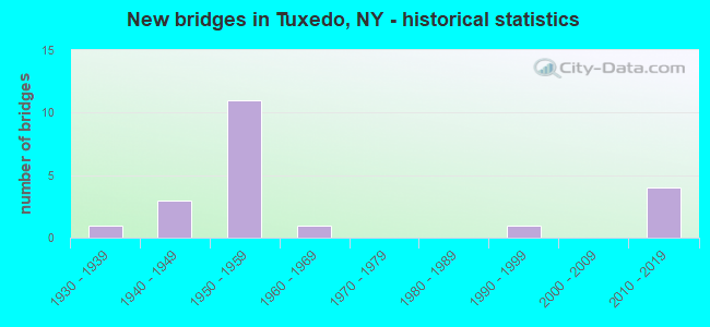
- New bridges - historical statistics
- 11930-1939
- 31940-1949
- 111950-1959
- 11960-1969
- 11990-1999
- 42010-2019

- Reconstructed bridges - Historical Statistics
- 21970-1979
- 01980-1989
- 21990-1999
- 02000-2009
- 12010-2019


- Bridge Condition - Deck
- 9.1%Excellent
- 18.2%Very good
- 18.2%Good
- 45.5%Satisfactory
- 9.1%Fair

- Bridge Condition - Superstructure
- 9.1%Excellent
- 27.3%Very good
- 27.3%Good
- 18.2%Satisfactory
- 18.2%Fair

- Bridge Condition - Substructure
- 9.1%Excellent
- 9.1%Very good
- 9.1%Good
- 27.3%Satisfactory
- 45.5%Fair

- Bridge Condition - Channel
- 12.5%Excellent
- 12.5%Very good
- 25.0%Good
- 50.0%Satisfactory

- Bridge Condition - Culverts
- 50.0%Excellent
- 50.0%Satisfactory
Find on map >> Show street view
Structure Number: 101404, Location: IN TUXEDO (Lat: 41.228644, Lng: -74.184439), Route carried "on" structure: State highway , Year Built: 1942, Year Reconstructed: 1978, Status: Open, Structure Length: 4.82m (15.81ft), Average Daily Traffic: 733 (year 2015), Truck Traffic: 1%, Average Future Daily Traffic: 764 (year 2040), Design Load: HS 20, Features Intersected: RTE 17, MNRR PJ LINE, Facility Carried by Structure: LAKE KANAWAUKE RD
Minimum Vertical Clearance: 30+ m (98+ ft), Kilometerpoint: 0.000, Lanes on structure: 2, Lanes under structure: 4, Owner: State Highway Agency, Approaching Roadway Width: 11.0m (36.1ft), Material/Design: Steel, Design/Construction: Stringer/Multi-beam, Number Of Spans In Main Unit: 2, Length of Maximum Span: 23.8m (78.1ft), Curb-To-Curb Width: 9.1m (29.9ft), Out-to-Out Width: 10.1m (33.1ft)
Condition: Deck: Satisfactory, Superstructure: Good, Substructure: Fair, Operating Rating: 59.9 metric tons, Method Used To Determine Operating Rating: Load Factor (LF), Inventory Rating: 36.3 metric tons, Method Used To Determine Inventory Rating: Load Factor (LF), Structural Evaluation: Somewhat better than minimum adequacy, Deck Geometry: Equal to present minimum criteria, Underclear: Meets minimum limits, Approach Roadway Alignment: Meets minimum limits, Length Of Structure Improvement: 4.81m (15.78ft), Designated Inspection Frequency: Every 24 months, Inspection Date: August 2021, Bridge Improvement Cost: $2,315,000, Roadway Improvement Cost: $1,356,000, Total Project Cost: $3,671,000 ( Estimate for 2021), Deck Structure Type: Concrete Cast-file-Place, Wearing Surface/Protective System: Wearing Surface: Integral Concrete, Deck Protection: Epoxy Coated Reinforcing
Find on map >> Show street view
Structure Number: 104084, Location: 0.1 MI E JCT RTS 210+17 (Lat: 41.228081, Lng: -74.183061), Route carried "on" structure: County highway , Year Built: 1947, Year Reconstructed: 1996, Status: Open, Structure Length: 5.79m (19.00ft), Average Daily Traffic: 733 (year 2015), Truck Traffic: 1%, Average Future Daily Traffic: 764 (year 2040), Design Load: HS 20, Features Intersected: RAMAPO RIVER, Facility Carried by Structure: KANAWAUKE ROAD
Minimum Vertical Clearance: 30+ m (98+ ft), Kilometerpoint: 0.113, Lanes on structure: 2, Owner: State Park, Forest, or Reservation Agency, Approaching Roadway Width: 7.3m (24.0ft), Skew: 2 degrees, Material/Design: Steel, Design/Construction: Stringer/Multi-beam, Number Of Spans In Main Unit: 3, Length of Maximum Span: 21.3m (69.9ft), Curb-To-Curb Width: 9.1m (29.9ft), Out-to-Out Width: 9.9m (32.5ft)
Condition: Deck: Good, Superstructure: Fair, Substructure: Satisfactory, Channel: Very good, Operating Rating: 60.8 metric tons, Method Used To Determine Operating Rating: Load Factor (LF), Inventory Rating: 36.3 metric tons, Method Used To Determine Inventory Rating: Load Factor (LF), Structural Evaluation: Somewhat better than minimum adequacy, Deck Geometry: Equal to present minimum criteria, Waterway Adequacy: Equal to present minimum criteria, Approach Roadway Alignment: Meets minimum limits, Length Of Structure Improvement: 5.79m (19.00ft), Designated Inspection Frequency: Every 24 months, Inspection Date: November 2020, Bridge Improvement Cost: $3,251,000, Roadway Improvement Cost: $1,904,000, Total Project Cost: $5,154,000 ( Estimate for 2021), Deck Structure Type: Concrete Cast-file-Place, Wearing Surface/Protective System: Wearing Surface: Bituminous, Deck Protection: Galvanized Reinforcing
Find on map >> Show street view
Structure Number: 334503, Location: 2.3 MI S OF HARRIMAN (Lat: 41.275425, Lng: -74.152717), Route carried "on" structure: Other road , Year Built: 1930, Year Reconstructed: 2004, Status: Open, Structure Length: 1.40m (4.59ft), Average Daily Traffic: 179 (year 2015), Truck Traffic: 5%, Average Future Daily Traffic: 251 (year 2035), Design Load: H 20, Features Intersected: RAMAPO RIVER, Facility Carried by Structure: ARDEN ROAD
Minimum Vertical Clearance: 30+ m (98+ ft), Kilometerpoint: 0.032, Lanes on structure: 2, Owner: County Highway Agency, Approaching Roadway Width: 8.2m (26.9ft), Material/Design: Prestressed concrete, Design/Construction: Box Beam or Girders - Multiple, Number Of Spans In Main Unit: 1, Length of Maximum Span: 13.4m (44.0ft), Curb-To-Curb Width: 9.1m (29.9ft), Out-to-Out Width: 10.1m (33.1ft)
Condition: Deck: Very good, Superstructure: Very good, Substructure: Satisfactory, Channel: Good, Operating Rating: 81.0 metric tons, Method Used To Determine Operating Rating: Load Factor (LF), Inventory Rating: 48.5 metric tons, Method Used To Determine Inventory Rating: Load Factor (LF), Structural Evaluation: Equal to present minimum criteria, Deck Geometry: Equal to present minimum criteria, Waterway Adequacy: Superior to present desirable criteria, Approach Roadway Alignment: Equal to present desirable criteria, Length Of Structure Improvement: 1.40m (4.59ft), Designated Inspection Frequency: Every 24 months, Inspection Date: August 2020, Bridge Improvement Cost: $753,000, Roadway Improvement Cost: $441,000, Total Project Cost: $1,194,000 ( Estimate for 2021), Wearing Surface/Protective System: Wearing Surface: Bituminous
Find on map >> Show street view
Structure Number: 334504, Location: 2.0 MI SE OF MOMBASHA LK (Lat: 41.255653, Lng: -74.184567), Route carried "on" structure: County highway , Year Built: 1999, Status: Open, Structure Length: 0.79m (2.59ft), Average Daily Traffic: 3,206 (year 2015), Truck Traffic: 2%, Average Future Daily Traffic: 4,488 (year 2035), Design Load: HS 25 or greater, Features Intersected: LITTLE DAM LAKE OUTLET, Facility Carried by Structure: COUNTY ROAD 19
Minimum Vertical Clearance: 30+ m (98+ ft), Kilometerpoint: 1.464, Lanes on structure: 2, Owner: County Highway Agency, Approaching Roadway Width: 10.7m (35.1ft), Material/Design: Aluminum, Iron, Design/Construction: Culvert, Number Of Spans In Main Unit: 1, Length of Maximum Span: 7.6m (24.9ft), Curb-To-Curb Width: 10.7m (35.1ft), Out-to-Out Width: 13.7m (44.9ft)
Condition: Channel: Good, Culverts: Excellent, Operating Rating: 78.0 metric tons, Method Used To Determine Operating Rating: Field evaluation and documented engineering judgment, Inventory Rating: 40.8 metric tons, Method Used To Determine Inventory Rating: Field evaluation and documented engineering judgment, Structural Evaluation: Superior to present desirable criteria, Deck Geometry: Somewhat better than minimum adequacy, Waterway Adequacy: Somewhat better than minimum adequacy, Approach Roadway Alignment: Equal to present desirable criteria, Length Of Structure Improvement: 0.79m (2.59ft), Designated Inspection Frequency: Every 24 months, Inspection Date: July 2020, Bridge Improvement Cost: $306,000, Roadway Improvement Cost: $179,000, Total Project Cost: $485,000 ( Estimate for 2021), Wearing Surface/Protective System: Wearing Surface: Bituminous
Find on map >> Show street view
Structure Number: 334505, Location: 2.3 MI W OF SLOATSBURG (Lat: 41.152711, Lng: -74.240228), Route carried "on" structure: County highway , Year Built: 1962, Status: Open, Structure Length: 1.25m (4.10ft), Average Daily Traffic: 1,858 (year 2015), Truck Traffic: 15%, Average Future Daily Traffic: 2,601 (year 2035), Design Load: H 20, Features Intersected: RINGWOOD RIVER, Facility Carried by Structure: STERLING LAKE ROAD
Minimum Vertical Clearance: 30+ m (98+ ft), Kilometerpoint: 0.225, Lanes on structure: 2, Owner: County Highway Agency, Approaching Roadway Width: 7.6m (24.9ft), Material/Design: Steel, Design/Construction: Stringer/Multi-beam, Number Of Spans In Main Unit: 1, Length of Maximum Span: 10.9m (35.8ft), Curb-To-Curb Width: 10.4m (34.1ft), Out-to-Out Width: 11.3m (37.1ft)
Condition: Deck: Satisfactory, Superstructure: Good, Substructure: Satisfactory, Channel: Satisfactory, Operating Rating: 51.7 metric tons, Method Used To Determine Operating Rating: Load Factor (LF), Inventory Rating: 30.8 metric tons, Method Used To Determine Inventory Rating: Load Factor (LF), Structural Evaluation: Equal to present minimum criteria, Deck Geometry: Equal to present minimum criteria, Waterway Adequacy: Meets minimum limits, Approach Roadway Alignment: Equal to present desirable criteria, Length Of Structure Improvement: 1.24m (4.07ft), Designated Inspection Frequency: Every 24 months, Inspection Date: October 2020, Bridge Improvement Cost: $956,000, Roadway Improvement Cost: $560,000, Total Project Cost: $1,516,000 ( Estimate for 2021), Deck Structure Type: Concrete Cast-file-Place, Wearing Surface/Protective System: Wearing Surface: Bituminous
Find on map >> Show street view
Structure Number: 334506, Location: AT TUXEDO PARK (Lat: 41.195575, Lng: -74.183381), Route carried "on" structure: Other road , Year Built: 2019, Status: Open, Structure Length: 3.19m (10.47ft), Average Daily Traffic: 561 (year 2015), Truck Traffic: 6%, Average Future Daily Traffic: 785 (year 2035), Design Load: HS 20, Features Intersected: RAMAPO RIVER, Facility Carried by Structure: VILLAGE ROAD
Minimum Vertical Clearance: 30+ m (98+ ft), Kilometerpoint: 0.129, Lanes on structure: 2, Owner: County Highway Agency, Approaching Roadway Width: 7.6m (24.9ft), Skew: 1 degrees, Material/Design: Prestressed concrete, Design/Construction: Box Beam or Girders - Multiple, Number Of Spans In Main Unit: 2, Length of Maximum Span: 31.2m (102.4ft), Curb-To-Curb Width: 9.2m (30.2ft), Out-to-Out Width: 10.1m (33.1ft)
Condition: Deck: Excellent, Superstructure: Excellent, Substructure: Excellent, Channel: Excellent, Operating Rating: 90.7 metric tons, Method Used To Determine Operating Rating: Load and Resistance Factor Rating (LRFR) rating reported by rating factor(RF) method using HL-93 loadings, Inventory Rating: 61.9 metric tons, Method Used To Determine Inventory Rating: Load and Resistance Factor Rating (LRFR) rating reported by rating factor(RF) method using HL-93 loadings, Structural Evaluation: Superior to present desirable criteria, Deck Geometry: Equal to present minimum criteria, Waterway Adequacy: Meets minimum limits, Approach Roadway Alignment: Equal to present minimum criteria, Length Of Structure Improvement: 3.19m (10.47ft), Designated Inspection Frequency: Every 24 months, Inspection Date: April 2020, Bridge Improvement Cost: $1,058,000, Roadway Improvement Cost: $619,000, Total Project Cost: $1,677,000 ( Estimate for 2021), Deck Structure Type: Concrete Cast-file-Place, Wearing Surface/Protective System: Wearing Surface: Monolithic Concrete, Deck Protection: Galvanized Reinforcing
Find on map >> Show street view
Structure Number: 5040851, Location: JCT 87I & RTE 210 (Lat: 41.227958, Lng: -74.181656), Route carried "on" structure: Interstate 87, Year Built: 1954, Year Reconstructed: 1977, Status: Open, Structure Length: 4.75m (15.58ft), Average Daily Traffic: 44,764 (year 2014), Truck Traffic: 20%, Features Intersected: COUNTY ROAD 106
Minimum Vertical Clearance: 30+ m (98+ ft), Kilometerpoint: 62.107, Lanes on structure: 3, Lanes under structure: 2, Base Highway Network: Yes, Toll: On Interstate toll segment, Owner: State Toll Authority, Approaching Roadway Width: 16.8m (55.1ft), Skew: 4 degrees, Material/Design: Steel, Design/Construction: Stringer/Multi-beam, Number Of Spans In Main Unit: 3, Length of Maximum Span: 19.2m (63.0ft), Curb or Sidewalk Widths: Left: 0.4m (1.3ft), Right: 0.3m (1.0ft), Curb-To-Curb Width: 15.8m (51.8ft), Out-to-Out Width: 17.1m (56.1ft)
Condition: Deck: Satisfactory, Superstructure: Satisfactory, Substructure: Fair, Operating Rating: 56.7 metric tons, Method Used To Determine Operating Rating: Load and Resistance Factor Rating (LRFR) rating reported by rating factor(RF) method using HL-93 loadings, Inventory Rating: 43.7 metric tons, Method Used To Determine Inventory Rating: Load and Resistance Factor Rating (LRFR) rating reported by rating factor(RF) method using HL-93 loadings, Structural Evaluation: Somewhat better than minimum adequacy, Deck Geometry: Somewhat better than minimum adequacy, Underclear: Meets minimum limits, Approach Roadway Alignment: Equal to present desirable criteria, Length Of Structure Improvement: 5.54m (18.18ft), Designated Inspection Frequency: Every 24 months, Inspection Date: May 2021, Bridge Improvement Cost: $3,818,000, Roadway Improvement Cost: $2,236,000, Total Project Cost: $6,053,000 ( Estimate for 2021), Deck Structure Type: Concrete Cast-file-Place, Wearing Surface/Protective System: Wearing Surface: Bituminous
Find on map >> Show street view
Structure Number: 5040852, Location: JCT 87I & RTE 210 (Lat: 41.228000, Lng: -74.181169), Route carried "on" structure: Interstate 87, Year Built: 1954, Status: Open, Structure Length: 5.55m (18.21ft), Average Daily Traffic: 35,789 (year 2019), Truck Traffic: 16%, Average Future Daily Traffic: 62,741 (year 2040), Features Intersected: COUNTY ROAD 106
Minimum Vertical Clearance: 30+ m (98+ ft), Kilometerpoint: 5.294, Lanes on structure: 3, Lanes under structure: 2, Base Highway Network: Yes, Toll: On Interstate toll segment, Owner: State Toll Authority, Approaching Roadway Width: 16.8m (55.1ft), Skew: 5 degrees, Material/Design: Steel, Design/Construction: Stringer/Multi-beam, Number Of Spans In Main Unit: 3, Length of Maximum Span: 22.6m (74.1ft), Curb or Sidewalk Widths: Left: 0.8m (2.6ft), Right: 0.8m (2.6ft), Curb-To-Curb Width: 14.9m (48.9ft), Out-to-Out Width: 17.1m (56.1ft)
Condition: Deck: Fair, Superstructure: Fair, Substructure: Fair, Operating Rating: 59.0 metric tons, Method Used To Determine Operating Rating: Load Factor (LF), Inventory Rating: 32.7 metric tons, Method Used To Determine Inventory Rating: Load Factor (LF), Structural Evaluation: Somewhat better than minimum adequacy, Deck Geometry: Meets minimum limits, Underclear: Somewhat better than minimum adequacy, Approach Roadway Alignment: Equal to present desirable criteria, Length Of Structure Improvement: 5.54m (18.18ft), Designated Inspection Frequency: Every 24 months, Inspection Date: May 2021, Bridge Improvement Cost: $3,818,000, Roadway Improvement Cost: $2,236,000, Total Project Cost: $6,053,000 ( Estimate for 2021), Deck Structure Type: Concrete Cast-file-Place, Wearing Surface/Protective System: Wearing Surface: Bituminous, Membrane: Other
Find on map >> Show street view
Structure Number: 551419, Location: 2.5 mi S JCT I87 & CR 106 (Lat: 41.193186, Lng: -74.181972), Route carried "on" structure: Interstate 87, Year Built: 2012, Status: Open, Structure Length: 1.31m (4.30ft), Average Daily Traffic: 71,578 (year 2019), Truck Traffic: 16%, Average Future Daily Traffic: 125,483 (year 2040), Design Load: HS 25 or greater, Features Intersected: EAST VILLAGE ROAD
Minimum Vertical Clearance: 30+ m (98+ ft), Kilometerpoint: 1.335, Lanes on structure: 6, Lanes under structure: 2, Base Highway Network: Yes, Toll: On Interstate toll segment, Owner: State Toll Authority, Approaching Roadway Width: 44.4m (145.7ft), Skew: 20 degrees, Material/Design: Concrete, Design/Construction: Frame, Number Of Spans In Main Unit: 1, Length of Maximum Span: 12.2m (40.0ft), Curb-To-Curb Width: 44.4m (145.7ft), Out-to-Out Width: 46.0m (150.9ft)
Condition: Deck: Very good, Superstructure: Very good, Substructure: Good, Operating Rating: 81.3 metric tons, Method Used To Determine Operating Rating: Field evaluation and documented engineering judgment, Inventory Rating: 40.8 metric tons, Method Used To Determine Inventory Rating: Field evaluation and documented engineering judgment, Structural Evaluation: Better than present minimum criteria, Deck Geometry: Superior to present desirable criteria, Underclear: Meets minimum limits, Approach Roadway Alignment: Equal to present desirable criteria, Length Of Structure Improvement: 1.31m (4.30ft), Designated Inspection Frequency: Every 24 months, Inspection Date: November 2021, Bridge Improvement Cost: $2,964,000, Roadway Improvement Cost: $1,736,000, Total Project Cost: $4,699,000 ( Estimate for 2021)
Find on map >> Show street view
Structure Number: 551421, Location: 3.2 MI SW JCT US 6 & I87 (Lat: 41.265839, Lng: -74.155392), Route carried "on" structure: Other road , Year Built: 1953, Status: Closed, Structure Length: 13.20m (43.31ft), Average Daily Traffic: 60 (year 1998), Average Future Daily Traffic: 84 (year 2018), Design Load: H 20, Features Intersected: 87IX, RTE I87, RAMAPO RI, Facility Carried by Structure: ARDEN VALLEY RD
Minimum Vertical Clearance: 30+ m (98+ ft), Kilometerpoint: 0.000, Lanes on structure: 2, Lanes under structure: 6, Owner: State Toll Authority, Approaching Roadway Width: 7.6m (24.9ft), Material/Design: Steel, Design/Construction: Stringer/Multi-beam, Number Of Spans In Main Unit: 5, Length of Maximum Span: 29.3m (96.1ft), Curb or Sidewalk Widths: Left: 1.3m (4.3ft), Right: 1.3m (4.3ft), Curb-To-Curb Width: 7.9m (25.9ft), Out-to-Out Width: 11.1m (36.4ft)
Condition: Deck: Satisfactory, Superstructure: Satisfactory, Substructure: Fair, Channel: Satisfactory, Deck Geometry: Equal to present minimum criteria, Waterway Adequacy: Equal to present minimum criteria, Approach Roadway Alignment: Equal to present minimum criteria, Bridge Posting: Required (Relationship of Operating Rating to Maximum Legal Load: > 39.9% below), Length Of Structure Improvement: 13.19m (43.27ft), Designated Inspection Frequency: Every 24 months, Inspection Date: December 2020, Bridge Improvement Cost: $5,406,000, Roadway Improvement Cost: $3,166,000, Total Project Cost: $8,571,000 ( Estimate for 2021), Deck Structure Type: Concrete Cast-file-Place, Wearing Surface/Protective System: Wearing Surface: Bituminous
Find on map >> Show street view
Structure Number: 5514229, Location: 2.7 MI SW JCT US 6 & I87 (Lat: 41.273506, Lng: -74.151072), Route carried "on" structure: Interstate 87, Year Built: 1953, Status: Open, Structure Length: 3.57m (11.71ft), Average Daily Traffic: 71,578 (year 2019), Truck Traffic: 16%, Average Future Daily Traffic: 125,483 (year 2040), Design Load: HS 20+Mod, Features Intersected: OTTER CREEK
Minimum Vertical Clearance: 30+ m (98+ ft), Kilometerpoint: 11.054, Lanes on structure: 6, Base Highway Network: Yes, Toll: On Interstate toll segment, Owner: State Toll Authority, Approaching Roadway Width: 32.6m (107.0ft), Skew: 36 degrees, Material/Design: Concrete, Design/Construction: Culvert, Number Of Spans In Main Unit: 2, Length of Maximum Span: 17.1m (56.1ft), Curb or Sidewalk Widths: Left: 0.8m (2.6ft), Right: 0.8m (2.6ft), Curb-To-Curb Width: 31.1m (102.0ft), Out-to-Out Width: 33.2m (108.9ft)
Condition: Channel: Satisfactory, Culverts: Satisfactory, Operating Rating: 20.4 metric tons, Method Used To Determine Operating Rating: Load and Resistance Factor Rating (LRFR) rating reported by rating factor(RF) method using HL-93 loadings, Inventory Rating: 15.6 metric tons, Method Used To Determine Inventory Rating: Load and Resistance Factor Rating (LRFR) rating reported by rating factor(RF) method using HL-93 loadings, Structural Evaluation: High priority of corrective action, Deck Geometry: Superior to present desirable criteria, Waterway Adequacy: Meets minimum limits, Approach Roadway Alignment: Equal to present desirable criteria, Length Of Structure Improvement: 3.56m (11.68ft), Designated Inspection Frequency: Every 12 months, Inspection Date: July 2021, Bridge Improvement Cost: $7,559,000, Roadway Improvement Cost: $4,426,000, Total Project Cost: $11,985,000 ( Estimate for 2021)
Find on map >> Show street view
Structure Number: 551423, Location: 2.5 MI SW JCT US 6 & I87 (Lat: 41.275442, Lng: -74.149700), Route carried "on" structure: Other road , Year Built: 1953, Year Reconstructed: 2010, Status: Open, Structure Length: 11.03m (36.19ft), Average Daily Traffic: 179 (year 2015), Truck Traffic: 5%, Average Future Daily Traffic: 251 (year 2035), Design Load: H 20, Features Intersected: 87IX, RTE I87, MNRR, Facility Carried by Structure: ARDEN RD
Minimum Vertical Clearance: 30+ m (98+ ft), Kilometerpoint: 0.257, Lanes on structure: 2, Lanes under structure: 6, Owner: State Toll Authority, Approaching Roadway Width: 7.9m (25.9ft), Material/Design: Steel, Design/Construction: Stringer/Multi-beam, Number Of Spans In Main Unit: 6, Length of Maximum Span: 22.3m (73.2ft), Curb or Sidewalk Widths: Left: 0.9m (3.0ft), Right: 0.9m (3.0ft), Curb-To-Curb Width: 7.9m (25.9ft), Out-to-Out Width: 11.1m (36.4ft)
Condition: Deck: Satisfactory, Superstructure: Good, Substructure: Fair, Operating Rating: 34.7 metric tons, Method Used To Determine Operating Rating: Load and Resistance Factor Rating (LRFR) rating reported by rating factor(RF) method using HL-93 loadings, Inventory Rating: 26.6 metric tons, Method Used To Determine Inventory Rating: Load and Resistance Factor Rating (LRFR) rating reported by rating factor(RF) method using HL-93 loadings, Structural Evaluation: Somewhat better than minimum adequacy, Deck Geometry: Somewhat better than minimum adequacy, Underclear: High priority of corrective action, Approach Roadway Alignment: Equal to present minimum criteria, Length Of Structure Improvement: 11.03m (36.19ft), Designated Inspection Frequency: Every 24 months, Inspection Date: December 2020, Bridge Improvement Cost: $4,468,000, Roadway Improvement Cost: $2,617,000, Total Project Cost: $7,085,000 ( Estimate for 2021), Deck Structure Type: Concrete Cast-file-Place, Wearing Surface/Protective System: Wearing Surface: Monolithic Concrete
Find on map >> Show street view
Structure Number: 552141, Location: 3.8 MI E OF SOUTHFIELDS (Lat: 41.240986, Lng: -74.102072), Route carried "on" structure: Other road 987E, Year Built: 2011, Status: Open, Structure Length: 1.34m (4.40ft), Average Daily Traffic: 899 (year 2016), Truck Traffic: 2%, Average Future Daily Traffic: 1,259 (year 2036), Design Load: HL 93, Features Intersected: ASKOTI DAM
Minimum Vertical Clearance: 30+ m (98+ ft), Kilometerpoint: 1.641, Lanes on structure: 2, Base Highway Network: Yes, Owner: State Park, Forest, or Reservation Agency, Approaching Roadway Width: 10.1m (33.1ft), Material/Design: Prestressed concrete, Design/Construction: Box Beam or Girders - Multiple, Number Of Spans In Main Unit: 1, Length of Maximum Span: 12.2m (40.0ft), Curb-To-Curb Width: 9.1m (29.9ft), Out-to-Out Width: 10.3m (33.8ft)
Condition: Deck: Good, Superstructure: Very good, Substructure: Very good, Channel: Satisfactory, Operating Rating: 66.1 metric tons, Method Used To Determine Operating Rating: Load and Resistance Factor Rating (LRFR) rating reported by rating factor(RF) method using HL-93 loadings, Inventory Rating: 51.2 metric tons, Method Used To Determine Inventory Rating: Load and Resistance Factor Rating (LRFR) rating reported by rating factor(RF) method using HL-93 loadings, Structural Evaluation: Equal to present desirable criteria, Deck Geometry: Equal to present minimum criteria, Waterway Adequacy: Superior to present desirable criteria, Approach Roadway Alignment: Equal to present desirable criteria, Length Of Structure Improvement: 1.34m (4.40ft), Designated Inspection Frequency: Every 24 months, Inspection Date: July 2020, Bridge Improvement Cost: $486,000, Roadway Improvement Cost: $284,000, Total Project Cost: $770,000 ( Estimate for 2021), Wearing Surface/Protective System: Wearing Surface: Monolithic Concrete
Find on map >> Show street view
Structure Number: 101404, Location: IN TUXEDO (Lat: 41.228644, Lng: -74.184439), Route carried "under" structure: State highway 17, Year Built: 1942, Structure Length: 0. m, Average Daily Traffic: 10,600 (year 1971), Features Intersected: RTE 17, MNRR PJ LINE, Facility Carried by Structure: LAKE KANAWAUKE RD
Minimum Vertical Clearance: 5.21m (17.09ft), Kilometerpoint: 20.515, Lanes on structure: 2, Lanes under structure: 4, Material/Design: Steel, Design/Construction: Stringer/Multi-beam, Length of Maximum Span: 23.8m (78.1ft)
Find on map >> Show street view
Structure Number: 5040851, Location: JCT 87I & RTE 210 (Lat: 41.227958, Lng: -74.181656), Route carried "under" structure: County highway , Year Built: 1954, Structure Length: 0. m, Average Daily Traffic: 3,000 (year 1979), Features Intersected: COUNTY ROAD 106, Facility Carried by Structure: RTE I87
Minimum Vertical Clearance: 4.34m (14.24ft), Kilometerpoint: 0.000, Lanes on structure: 3, Lanes under structure: 2, Material/Design: Steel, Design/Construction: Stringer/Multi-beam, Length of Maximum Span: 19.2m (63.0ft)
Find on map >> Show street view
Structure Number: 5040852, Location: JCT 87I & RTE 210 (Lat: 41.228000, Lng: -74.181169), Route carried "under" structure: County highway , Year Built: 1954, Structure Length: 0. m, Average Daily Traffic: 3,000 (year 1979), Features Intersected: COUNTY ROAD 106, Facility Carried by Structure: RTE I87
Minimum Vertical Clearance: 4.62m (15.16ft), Kilometerpoint: 0.000, Lanes on structure: 3, Lanes under structure: 2, Material/Design: Steel, Design/Construction: Stringer/Multi-beam, Length of Maximum Span: 22.6m (74.1ft)
Find on map >> Show street view
Structure Number: 551419, Location: 2.5 mi S JCT I87 & CR 106 (Lat: 41.193186, Lng: -74.181972), Route carried "under" structure: Other road , Year Built: 2012, Structure Length: 0. m, Features Intersected: EAST VILLAGE ROAD, Facility Carried by Structure: RTE 87
Minimum Vertical Clearance: 4.55m (14.93ft), Kilometerpoint: 0.000, Lanes on structure: 6, Lanes under structure: 2, Material/Design: Concrete, Design/Construction: Frame, Length of Maximum Span: 12.2m (40.0ft)
Find on map >> Show street view
Structure Number: 55142, Location: 1.3 MI N JCT I-87 & CR106 (Lat: 41.244444, Lng: -74.169981), Route carried "under" structure: Interstate 87, Year Built: 1956, Structure Length: 0. m, Average Daily Traffic: 19,150 (year 1978), Features Intersected: 87IX SB, RTE I87, Facility Carried by Structure: Southfield Pedestr
Minimum Vertical Clearance: 5.94m (19.49ft), Kilometerpoint: 64.199, Lanes under structure: 3, Toll: On Interstate toll segment, Material/Design: Steel, Design/Construction: Stringer/Multi-beam, Length of Maximum Span: 22.6m (74.1ft)
Find on map >> Show street view
Structure Number: 55142, Location: 1.3 MI N JCT I-87 & CR106 (Lat: 41.244444, Lng: -74.169981), Route carried "under" structure: Interstate , Year Built: 1956, Structure Length: 0. m, Features Intersected: 87IX SB, RTE I87, Facility Carried by Structure: Southfield Pedestr
Minimum Vertical Clearance: 6.15m (20.18ft), Kilometerpoint: 64.199, Lanes under structure: 3, Toll: On Interstate toll segment, Material/Design: Steel, Design/Construction: Stringer/Multi-beam, Length of Maximum Span: 22.6m (74.1ft)
Find on map >> Show street view
Structure Number: 551421, Location: 3.2 MI SW JCT US 6 & I87 (Lat: 41.265839, Lng: -74.155392), Route carried "under" structure: Interstate 87, Year Built: 1953, Structure Length: 0. m, Average Daily Traffic: 92,840 (year 2005), Features Intersected: 87IX, RTE I87, RAMAPO RI, Facility Carried by Structure: ARDEN VALLEY RD
Minimum Vertical Clearance: 6.40m (21.00ft), Kilometerpoint: 66.886, Lanes on structure: 2, Lanes under structure: 3, Toll: On Interstate toll segment, Material/Design: Steel, Design/Construction: Stringer/Multi-beam, Length of Maximum Span: 29.3m (96.1ft)
Find on map >> Show street view
Structure Number: 551423, Location: 2.5 MI SW JCT US 6 & I87 (Lat: 41.275442, Lng: -74.149700), Route carried "under" structure: Interstate 87, Year Built: 1953, Structure Length: 0. m, Average Daily Traffic: 92,840 (year 2005), Features Intersected: 87IX, RTE I87, MNRR, Facility Carried by Structure: ARDEN RD
Minimum Vertical Clearance: 5.64m (18.50ft), Kilometerpoint: 68.061, Lanes on structure: 2, Lanes under structure: 3, Toll: On Interstate toll segment, Material/Design: Steel, Design/Construction: Stringer/Multi-beam, Length of Maximum Span: 22.3m (73.2ft)