Bridge Statistics for Troupsburg, New York (NY)
Condition, Traffic, Stress, Structural Evaluation, Project Costs
- National Bridge Inventory (NBI) Statistics
- 15Number of bridges
- 98ft / 30.0mTotal length
- $15,458,000Total costs
- 5,316Total average daily traffic
- 580Total average daily truck traffic
- 6,201Total future (year 2037) average daily traffic
- National Bridge Inventory (NBI) Registered Bridges for Troupsburg
- No street view available for this location
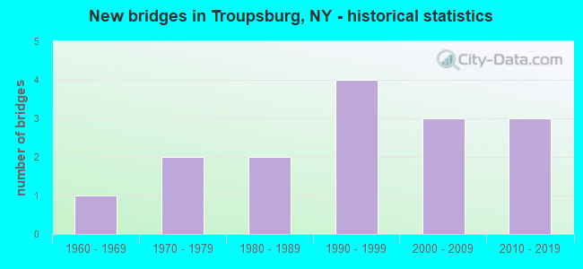
- New bridges - historical statistics
- 11960-1969
- 21970-1979
- 21980-1989
- 41990-1999
- 32000-2009
- 32010-2019

- Bridge Condition - Deck
- 23.1%Excellent
- 38.5%Very good
- 15.4%Good
- 15.4%Fair
- 7.7%Poor

- Bridge Condition - Superstructure
- 38.5%Excellent
- 30.8%Very good
- 7.7%Good
- 15.4%Fair
- 7.7%Poor

- Bridge Condition - Substructure
- 30.8%Excellent
- 30.8%Very good
- 7.7%Good
- 7.7%Satisfactory
- 23.1%Fair

- Bridge Condition - Channel
- 6.7%Excellent
- 13.3%Very good
- 20.0%Good
- 26.7%Satisfactory
- 33.3%Fair

- Bridge Condition - Culverts
- 50.0%Good
- 50.0%Satisfactory
Find on map >> Show street view
Structure Number: 102346, Location: 1.3 MI N OF PENN SL RTE36 (Lat: 42.016667, Lng: -77.521289), Route carried "on" structure: State highway 36, Year Built: 1978, Status: Open, Structure Length: 5.70m (18.70ft), Average Daily Traffic: 828 (year 2020), Truck Traffic: 9%, Average Future Daily Traffic: 863 (year 2040), Design Load: HS 20, Features Intersected: TROUPS CREEK
Minimum Vertical Clearance: 30+ m (98+ ft), Kilometerpoint: 2.381, Lanes on structure: 2, Base Highway Network: Yes, Owner: State Highway Agency, Approaching Roadway Width: 10.4m (34.1ft), Skew: 5 degrees, Material/Design: Steel continuous, Design/Construction: Stringer/Multi-beam, Number Of Spans In Main Unit: 2, Length of Maximum Span: 27.7m (90.9ft), Curb-To-Curb Width: 10.4m (34.1ft), Out-to-Out Width: 11.0m (36.1ft)
Condition: Deck: Fair, Superstructure: Fair, Substructure: Fair, Channel: Fair, Operating Rating: 39.9 metric tons, Method Used To Determine Operating Rating: Load and Resistance Factor Rating (LRFR) rating reported by rating factor(RF) method using HL-93 loadings, Inventory Rating: 30.8 metric tons, Method Used To Determine Inventory Rating: Load and Resistance Factor Rating (LRFR) rating reported by rating factor(RF) method using HL-93 loadings, Structural Evaluation: Somewhat better than minimum adequacy, Deck Geometry: Equal to present minimum criteria, Waterway Adequacy: Meets minimum limits, Approach Roadway Alignment: Equal to present desirable criteria, Length Of Structure Improvement: 5.69m (18.67ft), Designated Inspection Frequency: Every 24 months, Inspection Date: September 2021, Bridge Improvement Cost: $2,022,000, Roadway Improvement Cost: $1,184,000, Total Project Cost: $3,206,000 ( Estimate for 2021), Deck Structure Type: Concrete Cast-file-Place, Wearing Surface/Protective System: Wearing Surface: Epoxy Overlay, Deck Protection: Epoxy Coated Reinforcing
Find on map >> Show street view
Structure Number: 102347, Location: 2.0 MI SE OF TROUPSBURG (Lat: 42.017872, Lng: -77.521814), Route carried "on" structure: State highway 36, Year Built: 2008, Status: Open, Structure Length: 1.89m (6.20ft), Average Daily Traffic: 828 (year 2020), Truck Traffic: 9%, Average Future Daily Traffic: 863 (year 2040), Design Load: HL 93, Features Intersected: TRIB TROUPS CREEK
Minimum Vertical Clearance: 30+ m (98+ ft), Kilometerpoint: 2.542, Lanes on structure: 2, Base Highway Network: Yes, Owner: State Highway Agency, Approaching Roadway Width: 10.1m (33.1ft), Skew: 4 degrees, Material/Design: Prestressed concrete, Design/Construction: Stringer/Multi-beam, Number Of Spans In Main Unit: 1, Length of Maximum Span: 18.0m (59.1ft), Curb-To-Curb Width: 10.4m (34.1ft), Out-to-Out Width: 11.3m (37.1ft)
Condition: Deck: Good, Superstructure: Very good, Substructure: Very good, Channel: Satisfactory, Operating Rating: 71.7 metric tons, Method Used To Determine Operating Rating: Load Factor (LF), Inventory Rating: 42.9 metric tons, Method Used To Determine Inventory Rating: Load Factor (LF), Structural Evaluation: Equal to present desirable criteria, Deck Geometry: Equal to present minimum criteria, Waterway Adequacy: Equal to present desirable criteria, Approach Roadway Alignment: Equal to present desirable criteria, Length Of Structure Improvement: 1.88m (6.17ft), Designated Inspection Frequency: Every 24 months, Inspection Date: June 2020, Bridge Improvement Cost: $777,000, Roadway Improvement Cost: $455,000, Total Project Cost: $1,232,000 ( Estimate for 2021), Deck Structure Type: Concrete Cast-file-Place, Wearing Surface/Protective System: Wearing Surface: Integral Concrete, Deck Protection: Epoxy Coated Reinforcing
Find on map >> Show street view
Structure Number: 102348, Location: 0.3 MI SE of Troupsburg (Lat: 42.033869, Lng: -77.539414), Route carried "on" structure: State highway 36, Year Built: 2003, Status: Open, Structure Length: 1.04m (3.41ft), Average Daily Traffic: 828 (year 2020), Truck Traffic: 9%, Average Future Daily Traffic: 863 (year 2040), Design Load: HS 20, Features Intersected: Trib Troups Creek
Minimum Vertical Clearance: 30+ m (98+ ft), Kilometerpoint: 4.940, Lanes on structure: 2, Base Highway Network: Yes, Owner: State Highway Agency, Approaching Roadway Width: 11.0m (36.1ft), Design/Construction: Slab, Number Of Spans In Main Unit: 1, Length of Maximum Span: 9.1m (29.9ft), Curb-To-Curb Width: 10.3m (33.8ft), Out-to-Out Width: 11.3m (37.1ft)
Condition: Deck: Fair, Superstructure: Fair, Substructure: Satisfactory, Channel: Good, Operating Rating: 95.3 metric tons, Method Used To Determine Operating Rating: Load Factor (LF), Inventory Rating: 70.8 metric tons, Method Used To Determine Inventory Rating: Load Factor (LF), Structural Evaluation: Somewhat better than minimum adequacy, Deck Geometry: Equal to present minimum criteria, Waterway Adequacy: Equal to present desirable criteria, Approach Roadway Alignment: Equal to present desirable criteria, Length Of Structure Improvement: 1.03m (3.38ft), Designated Inspection Frequency: Every 24 months, Inspection Date: October 2021, Bridge Improvement Cost: $315,000, Roadway Improvement Cost: $184,000, Total Project Cost: $499,000 ( Estimate for 2021), Deck Structure Type: Other, Wearing Surface/Protective System: Wearing Surface: Epoxy Overlay
Find on map >> Show street view
Structure Number: 102349, Location: 1.3 MI N OF TROUPSBURG (Lat: 42.055769, Lng: -77.549864), Route carried "on" structure: State highway 36, Year Built: 1965, Status: Open, Structure Length: 1.31m (4.30ft), Average Daily Traffic: 982 (year 2020), Truck Traffic: 17%, Average Future Daily Traffic: 1,024 (year 2040), Design Load: HS 20, Features Intersected: COOVER HOLLOW CK
Minimum Vertical Clearance: 30+ m (98+ ft), Kilometerpoint: 7.627, Lanes on structure: 2, Base Highway Network: Yes, Owner: State Highway Agency, Approaching Roadway Width: 11.0m (36.1ft), Skew: 3 degrees, Material/Design: Concrete, Design/Construction: Culvert, Number Of Spans In Main Unit: 2, Length of Maximum Span: 6.1m (20.0ft), Curb-To-Curb Width: 11.0m (36.1ft), Out-to-Out Width: 12.0m (39.4ft)
Condition: Channel: Satisfactory, Culverts: Satisfactory, Operating Rating: 74.4 metric tons, Method Used To Determine Operating Rating: Load Factor (LF), Inventory Rating: 44.5 metric tons, Method Used To Determine Inventory Rating: Load Factor (LF), Structural Evaluation: Equal to present minimum criteria, Deck Geometry: Better than present minimum criteria, Waterway Adequacy: Meets minimum limits, Approach Roadway Alignment: Equal to present desirable criteria, Length Of Structure Improvement: 1.31m (4.30ft), Designated Inspection Frequency: Every 24 months, Inspection Date: May 2020, Bridge Improvement Cost: $793,000, Roadway Improvement Cost: $465,000, Total Project Cost: $1,258,000 ( Estimate for 2021), Wearing Surface/Protective System: Wearing Surface: Bituminous
Find on map >> Show street view
Structure Number: 221769, Location: 3.4 MI SE OF TROUPSBURG (Lat: 42.004133, Lng: -77.507214), Route carried "on" structure: Other road , Year Built: 2016, Status: Open, Structure Length: 3.23m (10.60ft), Average Daily Traffic: 90 (year 2017), Truck Traffic: 9%, Average Future Daily Traffic: 126 (year 2037), Design Load: HS 25 or greater, Features Intersected: TROUPS CREEK, Facility Carried by Structure: COOK HOLLOW ROAD
Minimum Vertical Clearance: 30+ m (98+ ft), Kilometerpoint: 0.048, Lanes on structure: 2, Owner: Town or Township Highway Agency, Maintenance Responsibility: County Highway Agency, Approaching Roadway Width: 6.1m (20.0ft), Material/Design: Prestressed concrete, Design/Construction: Box Beam or Girders - Multiple, Number Of Spans In Main Unit: 1, Length of Maximum Span: 31.7m (104.0ft), Curb-To-Curb Width: 7.3m (24.0ft), Out-to-Out Width: 7.5m (24.6ft)
Condition: Deck: Excellent, Superstructure: Excellent, Substructure: Excellent, Channel: Very good, Inventory Rating: 59.9 metric tons, Method Used To Determine Inventory Rating: Load Factor (LF), Structural Evaluation: Superior to present desirable criteria, Deck Geometry: Equal to present minimum criteria, Waterway Adequacy: Somewhat better than minimum adequacy, Approach Roadway Alignment: Better than present minimum criteria, Length Of Structure Improvement: 3.23m (10.60ft), Designated Inspection Frequency: Every 24 months, Inspection Date: September 2020, Bridge Improvement Cost: $678,000, Roadway Improvement Cost: $397,000, Total Project Cost: $1,075,000 ( Estimate for 2021), Wearing Surface/Protective System: Wearing Surface: Bituminous, Membrane: Other
Find on map >> Show street view
Structure Number: 22177, Location: IN VILLAGE OF TROUPSBURG (Lat: 42.042489, Lng: -77.549417), Route carried "on" structure: Other road , Year Built: 1990, Status: Posted for load, Structure Length: 1.62m (5.31ft), Average Daily Traffic: 50 (year 2018), Truck Traffic: 3%, Average Future Daily Traffic: 70 (year 2038), Design Load: HS 20, Features Intersected: TROUPS CREEK, Facility Carried by Structure: HOPPER HILL ROAD
Minimum Vertical Clearance: 30+ m (98+ ft), Kilometerpoint: 3.138, Lanes on structure: 1, Owner: Town or Township Highway Agency, Maintenance Responsibility: County Highway Agency, Approaching Roadway Width: 4.0m (13.1ft), Material/Design: Steel, Design/Construction: Girder and Floorbeam System, Number Of Spans In Main Unit: 1, Length of Maximum Span: 15.8m (51.8ft), Curb-To-Curb Width: 4.6m (15.1ft), Out-to-Out Width: 5.2m (17.1ft)
Condition: Deck: Poor, Superstructure: Poor, Substructure: Fair, Channel: Fair, Operating Rating: 5.2 metric tons, Method Used To Determine Operating Rating: Load and Resistance Factor Rating (LRFR) rating reported by rating factor(RF) method using HL-93 loadings, Inventory Rating: 3.9 metric tons, Method Used To Determine Inventory Rating: Load and Resistance Factor Rating (LRFR) rating reported by rating factor(RF) method using HL-93 loadings, Structural Evaluation: High priority of corrective action, Deck Geometry: Better than present minimum criteria, Waterway Adequacy: Meets minimum limits, Approach Roadway Alignment: Equal to present minimum criteria, Bridge Posting: Required (Relationship of Operating Rating to Maximum Legal Load: > 39.9% below), Length Of Structure Improvement: 1.61m (5.28ft), Designated Inspection Frequency: Every 12 months, Critical Feature Inspection Frequency: Every 12 months, Inspection Date: August 2021, Critical Feature Inspection Date: August 2021, Bridge Improvement Cost: $405,000, Roadway Improvement Cost: $237,000, Total Project Cost: $642,000 ( Estimate for 2021), Deck Structure Type: Wood or Timber, Wearing Surface/Protective System: Wearing Surface: Bituminous
Find on map >> Show street view
Structure Number: 221771, Location: 3.4 MI W OF TROUPSBURG (Lat: 42.050789, Lng: -77.607939), Route carried "on" structure: Other road , Year Built: 2012, Status: Open, Structure Length: 1.07m (3.51ft), Average Daily Traffic: 34 (year 2017), Truck Traffic: 5%, Average Future Daily Traffic: 48 (year 2037), Design Load: HS 25 or greater, Features Intersected: YOUNG HICKORY CRK, Facility Carried by Structure: MCALLISTER ROAD
Minimum Vertical Clearance: 30+ m (98+ ft), Kilometerpoint: 3.508, Lanes on structure: 2, Owner: Town or Township Highway Agency, Maintenance Responsibility: County Highway Agency, Approaching Roadway Width: 6.1m (20.0ft), Material/Design: Prestressed concrete, Design/Construction: Box Beam or Girders - Multiple, Number Of Spans In Main Unit: 1, Length of Maximum Span: 10.1m (33.1ft), Curb-To-Curb Width: 8.3m (27.2ft), Out-to-Out Width: 8.7m (28.5ft)
Condition: Deck: Excellent, Superstructure: Excellent, Substructure: Excellent, Channel: Very good, Operating Rating: 71.7 metric tons, Method Used To Determine Operating Rating: Load Factor (LF), Inventory Rating: 42.6 metric tons, Method Used To Determine Inventory Rating: Load Factor (LF), Structural Evaluation: Superior to present desirable criteria, Deck Geometry: Equal to present minimum criteria, Waterway Adequacy: Better than present minimum criteria, Approach Roadway Alignment: Equal to present desirable criteria, Length Of Structure Improvement: 1.06m (3.48ft), Designated Inspection Frequency: Every 24 months, Inspection Date: December 2020, Bridge Improvement Cost: $393,000, Roadway Improvement Cost: $230,000, Total Project Cost: $623,000 ( Estimate for 2021), Wearing Surface/Protective System: Wearing Surface: Bituminous
Find on map >> Show street view
Structure Number: 221772, Location: 2.6 MI W OF WOODHULL (Lat: 42.076397, Lng: -77.458278), Route carried "on" structure: Other road , Year Built: 2003, Status: Open, Structure Length: 1.16m (3.81ft), Average Daily Traffic: 51 (year 2017), Truck Traffic: 5%, Average Future Daily Traffic: 71 (year 2037), Design Load: HS 25 or greater, Features Intersected: HOPPER CREEK, Facility Carried by Structure: OLMSTEAD ROAD
Minimum Vertical Clearance: 30+ m (98+ ft), Kilometerpoint: 6.162, Lanes on structure: 2, Owner: Town or Township Highway Agency, Maintenance Responsibility: County Highway Agency, Approaching Roadway Width: 5.5m (18.0ft), Skew: 2 degrees, Material/Design: Prestressed concrete, Design/Construction: Box Beam or Girders - Multiple, Number Of Spans In Main Unit: 1, Length of Maximum Span: 10.9m (35.8ft), Curb-To-Curb Width: 8.1m (26.6ft), Out-to-Out Width: 8.6m (28.2ft)
Condition: Deck: Very good, Superstructure: Very good, Substructure: Very good, Channel: Good, Operating Rating: 76.2 metric tons, Method Used To Determine Operating Rating: Load Factor (LF), Inventory Rating: 45.4 metric tons, Method Used To Determine Inventory Rating: Load Factor (LF), Structural Evaluation: Equal to present desirable criteria, Deck Geometry: Equal to present minimum criteria, Waterway Adequacy: Better than present minimum criteria, Approach Roadway Alignment: Equal to present desirable criteria, Length Of Structure Improvement: 1.15m (3.77ft), Designated Inspection Frequency: Every 24 months, Inspection Date: March 2021, Bridge Improvement Cost: $354,000, Roadway Improvement Cost: $207,000, Total Project Cost: $561,000 ( Estimate for 2021), Wearing Surface/Protective System: Wearing Surface: Bituminous
Find on map >> Show street view
Structure Number: 333408, Location: 1.3 MI S OF TROUPSBURG (Lat: 42.027108, Lng: -77.535478), Route carried "on" structure: County highway , Year Built: 2010, Status: Open, Structure Length: 1.89m (6.20ft), Average Daily Traffic: 266 (year 2017), Truck Traffic: 15%, Average Future Daily Traffic: 372 (year 2037), Design Load: HS 25 or greater, Features Intersected: TROUPS CREEK, Facility Carried by Structure: COUNTY ROAD 84
Minimum Vertical Clearance: 30+ m (98+ ft), Kilometerpoint: 17.055, Lanes on structure: 2, Owner: County Highway Agency, Approaching Roadway Width: 7.9m (25.9ft), Material/Design: Prestressed concrete, Design/Construction: Box Beam or Girders - Multiple, Number Of Spans In Main Unit: 1, Length of Maximum Span: 18.3m (60.0ft), Curb-To-Curb Width: 9.5m (31.2ft), Out-to-Out Width: 10.0m (32.8ft)
Condition: Deck: Excellent, Superstructure: Excellent, Substructure: Excellent, Channel: Excellent, Operating Rating: 74.4 metric tons, Method Used To Determine Operating Rating: Load Factor (LF), Inventory Rating: 44.5 metric tons, Method Used To Determine Inventory Rating: Load Factor (LF), Structural Evaluation: Superior to present desirable criteria, Deck Geometry: Equal to present minimum criteria, Waterway Adequacy: Better than present minimum criteria, Approach Roadway Alignment: Equal to present minimum criteria, Length Of Structure Improvement: 1.88m (6.17ft), Designated Inspection Frequency: Every 24 months, Inspection Date: December 2020, Bridge Improvement Cost: $652,000, Roadway Improvement Cost: $382,000, Total Project Cost: $1,033,000 ( Estimate for 2021), Wearing Surface/Protective System: Wearing Surface: Bituminous, Membrane: Other
Find on map >> Show street view
Structure Number: 333409, Location: 1.9 MI SW OF TROUPSBURG (Lat: 42.020403, Lng: -77.568197), Route carried "on" structure: County highway , Year Built: 1995, Status: Open, Structure Length: 1.16m (3.81ft), Average Daily Traffic: 266 (year 2017), Truck Traffic: 15%, Average Future Daily Traffic: 372 (year 2037), Design Load: HS 20, Features Intersected: SQUAB HOLLOW CRK, Facility Carried by Structure: COUNTY ROAD 84
Minimum Vertical Clearance: 30+ m (98+ ft), Kilometerpoint: 14.143, Lanes on structure: 2, Owner: County Highway Agency, Approaching Roadway Width: 8.2m (26.9ft), Skew: 2 degrees, Material/Design: Prestressed concrete, Design/Construction: Box Beam or Girders - Multiple, Number Of Spans In Main Unit: 1, Length of Maximum Span: 10.9m (35.8ft), Curb-To-Curb Width: 9.4m (30.8ft), Out-to-Out Width: 9.8m (32.2ft)
Condition: Deck: Very good, Superstructure: Very good, Substructure: Very good, Channel: Good, Operating Rating: 67.1 metric tons, Method Used To Determine Operating Rating: Load Factor (LF), Inventory Rating: 41.7 metric tons, Method Used To Determine Inventory Rating: Load Factor (LF), Structural Evaluation: Equal to present desirable criteria, Deck Geometry: Equal to present minimum criteria, Waterway Adequacy: Better than present minimum criteria, Approach Roadway Alignment: Equal to present desirable criteria, Length Of Structure Improvement: 1.15m (3.77ft), Designated Inspection Frequency: Every 24 months, Inspection Date: October 2021, Bridge Improvement Cost: $503,000, Roadway Improvement Cost: $294,000, Total Project Cost: $797,000 ( Estimate for 2021), Wearing Surface/Protective System: Wearing Surface: Bituminous, Membrane: Other
Find on map >> Show street view
Structure Number: 33341, Location: 2 MILES SW OF TROUPSBURG (Lat: 42.021556, Lng: -77.572536), Route carried "on" structure: County highway , Year Built: 1990, Status: Open, Structure Length: 2.77m (9.09ft), Average Daily Traffic: 129 (year 2018), Truck Traffic: 14%, Average Future Daily Traffic: 181 (year 2038), Design Load: HS 20, Features Intersected: SQUAB HOLLOW CRK, Facility Carried by Structure: COUNTY ROAD 84
Minimum Vertical Clearance: 30+ m (98+ ft), Kilometerpoint: 13.741, Lanes on structure: 2, Owner: County Highway Agency, Approaching Roadway Width: 5.5m (18.0ft), Skew: 2 degrees, Material/Design: Prestressed concrete, Design/Construction: Box Beam or Girders - Multiple, Number Of Spans In Main Unit: 1, Length of Maximum Span: 26.2m (86.0ft), Curb-To-Curb Width: 8.0m (26.2ft), Out-to-Out Width: 8.7m (28.5ft)
Condition: Deck: Good, Superstructure: Good, Substructure: Good, Channel: Fair, Operating Rating: 86.2 metric tons, Method Used To Determine Operating Rating: Load Factor (LF), Inventory Rating: 40.8 metric tons, Method Used To Determine Inventory Rating: Load Factor (LF), Structural Evaluation: Better than present minimum criteria, Deck Geometry: Somewhat better than minimum adequacy, Waterway Adequacy: Somewhat better than minimum adequacy, Approach Roadway Alignment: Equal to present desirable criteria, Length Of Structure Improvement: 2.77m (9.09ft), Designated Inspection Frequency: Every 24 months, Inspection Date: August 2021, Bridge Improvement Cost: $596,000, Roadway Improvement Cost: $349,000, Total Project Cost: $944,000 ( Estimate for 2021), Deck Structure Type: Concrete Cast-file-Place, Wearing Surface/Protective System: Wearing Surface: Bituminous
Find on map >> Show street view
Structure Number: 333434, Location: 3.2 MI NW OF TROUPSBURG (Lat: 42.053897, Lng: -77.602333), Route carried "on" structure: County highway , Year Built: 1983, Status: Open, Structure Length: 0.94m (3.08ft), Average Daily Traffic: 241 (year 2017), Truck Traffic: 9%, Average Future Daily Traffic: 337 (year 2037), Design Load: HS 20, Features Intersected: KEEGANS CREEK, Facility Carried by Structure: COUNTY ROAD 117
Minimum Vertical Clearance: 30+ m (98+ ft), Kilometerpoint: 6.516, Lanes on structure: 2, Owner: County Highway Agency, Approaching Roadway Width: 6.4m (21.0ft), Material/Design: Concrete continuous, Design/Construction: Culvert, Number Of Spans In Main Unit: 2, Length of Maximum Span: 4.5m (14.8ft), Curb-To-Curb Width: 8.5m (27.9ft), Out-to-Out Width: 9.1m (29.9ft)
Condition: Channel: Fair, Culverts: Good, Operating Rating: 89.8 metric tons, Method Used To Determine Operating Rating: Load Factor (LF), Inventory Rating: 55.3 metric tons, Method Used To Determine Inventory Rating: Load Factor (LF), Structural Evaluation: Better than present minimum criteria, Deck Geometry: Equal to present minimum criteria, Waterway Adequacy: Meets minimum limits, Approach Roadway Alignment: Equal to present desirable criteria, Length Of Structure Improvement: 0.94m (3.08ft), Designated Inspection Frequency: Every 24 months, Inspection Date: August 2021, Bridge Improvement Cost: $284,000, Roadway Improvement Cost: $167,000, Total Project Cost: $451,000 ( Estimate for 2021)
Find on map >> Show street view
Structure Number: 333435, Location: 3.5 MI W 0F TROOPSBURG (Lat: 42.036914, Lng: -77.572164), Route carried "on" structure: County highway , Year Built: 1991, Status: Open, Structure Length: 2.80m (9.19ft), Average Daily Traffic: 241 (year 2017), Truck Traffic: 9%, Average Future Daily Traffic: 337 (year 2037), Design Load: HS 20, Features Intersected: YOUNG HICKORY CRK, Facility Carried by Structure: COUNTY ROAD 117
Minimum Vertical Clearance: 30+ m (98+ ft), Kilometerpoint: 9.911, Lanes on structure: 2, Owner: County Highway Agency, Approaching Roadway Width: 5.5m (18.0ft), Skew: 4 degrees, Material/Design: Steel, Design/Construction: Stringer/Multi-beam, Number Of Spans In Main Unit: 1, Length of Maximum Span: 26.8m (87.9ft), Curb-To-Curb Width: 9.1m (29.9ft), Out-to-Out Width: 9.8m (32.2ft)
Condition: Deck: Very good, Superstructure: Excellent, Substructure: Excellent, Channel: Fair, Inventory Rating: 65.3 metric tons, Method Used To Determine Inventory Rating: Load Factor (LF), Structural Evaluation: Superior to present desirable criteria, Deck Geometry: Equal to present minimum criteria, Waterway Adequacy: Better than present minimum criteria, Approach Roadway Alignment: Equal to present minimum criteria, Length Of Structure Improvement: 2.80m (9.19ft), Designated Inspection Frequency: Every 24 months, Inspection Date: October 2021, Bridge Improvement Cost: $793,000, Roadway Improvement Cost: $464,000, Total Project Cost: $1,257,000 ( Estimate for 2021), Deck Structure Type: Concrete Cast-file-Place, Wearing Surface/Protective System: Wearing Surface: Integral Concrete, Deck Protection: Epoxy Coated Reinforcing
Find on map >> Show street view
Structure Number: 333436, Location: .7 MILE SW OF TROUPSBURG (Lat: 42.035792, Lng: -77.557919), Route carried "on" structure: County highway , Year Built: 1989, Status: Open, Structure Length: 1.55m (5.09ft), Average Daily Traffic: 241 (year 2017), Truck Traffic: 9%, Average Future Daily Traffic: 337 (year 2037), Design Load: HS 20, Features Intersected: YOUNG HICKORY CRK, Facility Carried by Structure: COUNTY ROAD 117
Minimum Vertical Clearance: 30+ m (98+ ft), Kilometerpoint: 11.134, Lanes on structure: 2, Owner: County Highway Agency, Approaching Roadway Width: 7.3m (24.0ft), Skew: 2 degrees, Material/Design: Wood or Timber, Design/Construction: Stringer/Multi-beam, Number Of Spans In Main Unit: 1, Length of Maximum Span: 15.2m (49.9ft), Curb-To-Curb Width: 8.7m (28.5ft), Out-to-Out Width: 9.1m (29.9ft)
Condition: Deck: Very good, Superstructure: Very good, Substructure: Fair, Channel: Satisfactory, Operating Rating: 83.5 metric tons, Method Used To Determine Operating Rating: Field evaluation and documented engineering judgment, Inventory Rating: 32.7 metric tons, Method Used To Determine Inventory Rating: Field evaluation and documented engineering judgment, Structural Evaluation: Somewhat better than minimum adequacy, Deck Geometry: Equal to present minimum criteria, Waterway Adequacy: Better than present minimum criteria, Approach Roadway Alignment: Better than present minimum criteria, Length Of Structure Improvement: 1.55m (5.09ft), Designated Inspection Frequency: Every 24 months, Inspection Date: October 2021, Bridge Improvement Cost: $538,000, Roadway Improvement Cost: $315,000, Total Project Cost: $853,000 ( Estimate for 2021), Deck Structure Type: Wood or Timber, Wearing Surface/Protective System: Wearing Surface: Bituminous
Find on map >> Show street view
Structure Number: 333437, Location: .3 MILE S OF TROUPSBURG (Lat: 42.035553, Lng: -77.542931), Route carried "on" structure: County highway , Year Built: 1978, Year Reconstructed: 2006, Status: Open, Structure Length: 1.86m (6.10ft), Average Daily Traffic: 241 (year 2017), Truck Traffic: 9%, Average Future Daily Traffic: 337 (year 2037), Design Load: H 20, Features Intersected: TROUPS CREEK, Facility Carried by Structure: COUNTY ROAD 117
Minimum Vertical Clearance: 30+ m (98+ ft), Kilometerpoint: 12.389, Lanes on structure: 2, Owner: County Highway Agency, Approaching Roadway Width: 7.3m (24.0ft), Skew: 2 degrees, Material/Design: Prestressed concrete, Design/Construction: Box Beam or Girders - Multiple, Number Of Spans In Main Unit: 1, Length of Maximum Span: 18.3m (60.0ft), Curb-To-Curb Width: 8.2m (26.9ft), Out-to-Out Width: 8.7m (28.5ft)
Condition: Deck: Very good, Superstructure: Excellent, Substructure: Very good, Channel: Satisfactory, Operating Rating: 79.8 metric tons, Method Used To Determine Operating Rating: Load Factor (LF), Inventory Rating: 47.2 metric tons, Method Used To Determine Inventory Rating: Load Factor (LF), Structural Evaluation: Equal to present desirable criteria, Deck Geometry: Somewhat better than minimum adequacy, Waterway Adequacy: Superior to present desirable criteria, Approach Roadway Alignment: Superior to present desirable criteria, Length Of Structure Improvement: 1.85m (6.07ft), Designated Inspection Frequency: Every 24 months, Inspection Date: October 2021, Bridge Improvement Cost: $648,000, Roadway Improvement Cost: $379,000, Total Project Cost: $1,027,000 ( Estimate for 2021), Wearing Surface/Protective System: Wearing Surface: Bituminous