Bridge Statistics for Taghkanic, New York (NY)
Condition, Traffic, Stress, Structural Evaluation, Project Costs
- National Bridge Inventory (NBI) Statistics
- 13Number of bridges
- 75ft / 23.4mTotal length
- $21,537,000Total costs
- 18,163Total average daily traffic
- 375Total average daily truck traffic
- National Bridge Inventory (NBI) Registered Bridges for Taghkanic
- No street view available for this location
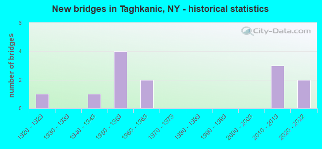
- New bridges - historical statistics
- 11920-1929
- 11940-1949
- 41950-1959
- 21960-1969
- 32010-2019
- 22020-2022


- Bridge Condition - Deck
- 10.0%Very good
- 30.0%Good
- 20.0%Satisfactory
- 10.0%Fair
- 30.0%Poor

- Bridge Condition - Superstructure
- 20.0%Excellent
- 20.0%Very good
- 10.0%Satisfactory
- 30.0%Fair
- 20.0%Poor

- Bridge Condition - Substructure
- 10.0%Very good
- 30.0%Good
- 20.0%Satisfactory
- 40.0%Fair

- Bridge Condition - Channel
- 22.2%Good
- 44.4%Satisfactory
- 33.3%Fair
Find on map >> Show street view
Structure Number: 103238, Location: JCT RTE 82+TSP (Lat: 42.117917, Lng: -73.714608), Route carried "on" structure: State highway 82, Year Built: 1952, Status: Open, Structure Length: 3.08m (10.10ft), Average Daily Traffic: 1,102 (year 2019), Truck Traffic: 13%, Average Future Daily Traffic: 1,149 (year 2040), Design Load: HS 20, Features Intersected: RTE 987G
Minimum Vertical Clearance: 30+ m (98+ ft), Kilometerpoint: 7.836, Lanes on structure: 4, Lanes under structure: 4, Base Highway Network: Yes, Owner: State Highway Agency, Approaching Roadway Width: 17.1m (56.1ft), Skew: 3 degrees, Material/Design: Concrete, Design/Construction: Frame, Number Of Spans In Main Unit: 2, Length of Maximum Span: 15.2m (49.9ft), Curb-To-Curb Width: 17.1m (56.1ft), Out-to-Out Width: 19.5m (64.0ft)
Condition: Deck: Satisfactory, Superstructure: Satisfactory, Substructure: Fair, Operating Rating: 83.5 metric tons, Method Used To Determine Operating Rating: Field evaluation and documented engineering judgment, Inventory Rating: 32.7 metric tons, Method Used To Determine Inventory Rating: Field evaluation and documented engineering judgment, Structural Evaluation: Somewhat better than minimum adequacy, Deck Geometry: Somewhat better than minimum adequacy, Underclear: Meets minimum limits, Approach Roadway Alignment: Equal to present desirable criteria, Length Of Structure Improvement: 3.07m (10.07ft), Designated Inspection Frequency: Every 24 months, Inspection Date: July 2021, Bridge Improvement Cost: $3,334,000, Roadway Improvement Cost: $1,952,000, Total Project Cost: $5,286,000 ( Estimate for 2021)
Find on map >> Show street view
Structure Number: 322293, Location: 0.9 MI S OF W TAGHKANIC (Lat: 42.137042, Lng: -73.726942), Route carried "on" structure: Other road , Year Built: 1922, Status: Open, Structure Length: 2.10m (6.89ft), Average Daily Traffic: 124 (year 2018), Truck Traffic: 2%, Average Future Daily Traffic: 174 (year 2038), Features Intersected: TAGHKANIC CREEK, Facility Carried by Structure: OLD ROUTE 82
Minimum Vertical Clearance: 30+ m (98+ ft), Kilometerpoint: 1.641, Lanes on structure: 2, Owner: County Highway Agency, Approaching Roadway Width: 6.1m (20.0ft), Skew: 4 degrees, Material/Design: Steel, Design/Construction: Stringer/Multi-beam, Number Of Spans In Main Unit: 2, Length of Maximum Span: 10.1m (33.1ft), Curb-To-Curb Width: 6.2m (20.3ft), Out-to-Out Width: 7.2m (23.6ft)
Condition: Deck: Poor, Superstructure: Poor, Substructure: Fair, Channel: Satisfactory, Operating Rating: 65.3 metric tons, Method Used To Determine Operating Rating: Load Factor (LF), Inventory Rating: 39.0 metric tons, Method Used To Determine Inventory Rating: Load Factor (LF), Structural Evaluation: Meets minimum limits, Deck Geometry: Meets minimum limits, Waterway Adequacy: Meets minimum limits, Approach Roadway Alignment: Meets minimum limits, Length Of Structure Improvement: 2.10m (6.89ft), Designated Inspection Frequency: Every 24 months, Inspection Date: August 2020, Bridge Improvement Cost: $869,000, Roadway Improvement Cost: $509,000, Total Project Cost: $1,378,000 ( Estimate for 2021), Deck Structure Type: Concrete Cast-file-Place, Wearing Surface/Protective System: Wearing Surface: Bituminous
Find on map >> Show street view
Structure Number: 322294, Location: 1.1 MI NW OF COPAKE LAKE (Lat: 42.160239, Lng: -73.610981), Route carried "on" structure: Other road , Year Built: 1940, Status: Open, Structure Length: 1.77m (5.81ft), Average Daily Traffic: 658 (year 2017), Truck Traffic: 3%, Average Future Daily Traffic: 921 (year 2037), Features Intersected: TAGHKANIC CREEK, Facility Carried by Structure: COPAKE LAKE RD
Minimum Vertical Clearance: 30+ m (98+ ft), Kilometerpoint: 0.418, Lanes on structure: 2, Owner: County Highway Agency, Approaching Roadway Width: 7.3m (24.0ft), Skew: 3 degrees, Material/Design: Steel, Design/Construction: Stringer/Multi-beam, Number Of Spans In Main Unit: 1, Length of Maximum Span: 17.0m (55.8ft), Curb-To-Curb Width: 7.5m (24.6ft), Out-to-Out Width: 8.4m (27.6ft)
Condition: Deck: Fair, Superstructure: Fair, Substructure: Satisfactory, Channel: Satisfactory, Operating Rating: 78.1 metric tons, Method Used To Determine Operating Rating: Load and Resistance Factor Rating (LRFR) rating reported by rating factor(RF) method using HL-93 loadings, Inventory Rating: 60.3 metric tons, Method Used To Determine Inventory Rating: Load and Resistance Factor Rating (LRFR) rating reported by rating factor(RF) method using HL-93 loadings, Structural Evaluation: Somewhat better than minimum adequacy, Deck Geometry: Meets minimum limits, Waterway Adequacy: Superior to present desirable criteria, Approach Roadway Alignment: Equal to present minimum criteria, Length Of Structure Improvement: 1.76m (5.77ft), Designated Inspection Frequency: Every 24 months, Inspection Date: April 2020, Bridge Improvement Cost: $893,000, Roadway Improvement Cost: $523,000, Total Project Cost: $1,416,000 ( Estimate for 2021), Deck Structure Type: Concrete Cast-file-Place, Wearing Surface/Protective System: Wearing Surface: Bituminous
Find on map >> Show street view
Structure Number: 322295, Location: 1.1 MI W OF COPAKE LAKE (Lat: 42.150347, Lng: -73.622842), Route carried "on" structure: Other road , Year Built: 1961, Status: Open, Structure Length: 2.38m (7.81ft), Average Daily Traffic: 83 (year 2016), Truck Traffic: 8%, Average Future Daily Traffic: 116 (year 2036), Design Load: H 20, Features Intersected: TAGHKANIC CREEK, Facility Carried by Structure: BERKSHIRE ROAD
Minimum Vertical Clearance: 30+ m (98+ ft), Kilometerpoint: 2.848, Lanes on structure: 2, Owner: County Highway Agency, Approaching Roadway Width: 7.3m (24.0ft), Skew: 3 degrees, Material/Design: Prestressed concrete, Design/Construction: Box Beam or Girders - Multiple, Number Of Spans In Main Unit: 1, Length of Maximum Span: 23.1m (75.8ft), Curb-To-Curb Width: 7.6m (24.9ft), Out-to-Out Width: 8.3m (27.2ft)
Condition: Deck: Satisfactory, Superstructure: Poor, Substructure: Satisfactory, Channel: Fair, Operating Rating: 70.3 metric tons, Method Used To Determine Operating Rating: Load and Resistance Factor Rating (LRFR) rating reported by rating factor(RF) method using HL-93 loadings, Inventory Rating: 51.8 metric tons, Method Used To Determine Inventory Rating: Load and Resistance Factor Rating (LRFR) rating reported by rating factor(RF) method using HL-93 loadings, Structural Evaluation: Meets minimum limits, Deck Geometry: Equal to present minimum criteria, Waterway Adequacy: Meets minimum limits, Approach Roadway Alignment: Somewhat better than minimum adequacy, Length Of Structure Improvement: 2.37m (7.78ft), Designated Inspection Frequency: Every 24 months, Inspection Date: August 2021, Bridge Improvement Cost: $729,000, Roadway Improvement Cost: $427,000, Total Project Cost: $1,156,000 ( Estimate for 2021), Wearing Surface/Protective System: Wearing Surface: Bituminous
Find on map >> Show street view
Structure Number: 322297, Location: 2.7 MI SE OF W. TAGHKANIC (Lat: 42.106450, Lng: -73.673872), Route carried "on" structure: Other road , Year Built: 2014, Status: Open, Structure Length: 1.74m (5.71ft), Average Daily Traffic: 9 (year 2016), Truck Traffic: 8%, Average Future Daily Traffic: 13 (year 2036), Design Load: HS 20, Features Intersected: TAGHKANIC CREEK, Facility Carried by Structure: NEW FORGE ROAD 2
Minimum Vertical Clearance: 30+ m (98+ ft), Kilometerpoint: 1.432, Lanes on structure: 1, Owner: County Highway Agency, Approaching Roadway Width: 5.2m (17.1ft), Material/Design: Prestressed concrete, Design/Construction: Box Beam or Girders - Multiple, Number Of Spans In Main Unit: 1, Length of Maximum Span: 16.5m (54.1ft), Curb-To-Curb Width: 5.2m (17.1ft), Out-to-Out Width: 6.4m (21.0ft)
Condition: Deck: Good, Superstructure: Very good, Substructure: Good, Channel: Good, Inventory Rating: 68.9 metric tons, Method Used To Determine Inventory Rating: Load Factor (LF), Structural Evaluation: Better than present minimum criteria, Deck Geometry: High priority of corrective action, Waterway Adequacy: Equal to present minimum criteria, Approach Roadway Alignment: Meets minimum limits, Length Of Structure Improvement: 1.73m (5.68ft), Designated Inspection Frequency: Every 24 months, Inspection Date: November 2020, Bridge Improvement Cost: $475,000, Roadway Improvement Cost: $278,000, Total Project Cost: $753,000 ( Estimate for 2021), Deck Structure Type: Concrete Cast-file-Place, Wearing Surface/Protective System: Wearing Surface: Integral Concrete, Deck Protection: Epoxy Coated Reinforcing
Find on map >> Show street view
Structure Number: 33423, Location: AT W TAGHKANIC (Lat: 42.123575, Lng: -73.721167), Route carried "on" structure: County highway , Year Built: 1954, Status: Open, Structure Length: 2.35m (7.71ft), Average Daily Traffic: 719 (year 2020), Truck Traffic: 9%, Average Future Daily Traffic: 1,007 (year 2040), Features Intersected: TAGHKANIC CREEK, Facility Carried by Structure: COUNTY ROAD 10
Minimum Vertical Clearance: 30+ m (98+ ft), Kilometerpoint: 0.048, Lanes on structure: 2, Owner: County Highway Agency, Approaching Roadway Width: 7.0m (23.0ft), Material/Design: Steel, Design/Construction: Stringer/Multi-beam, Number Of Spans In Main Unit: 1, Length of Maximum Span: 22.2m (72.8ft), Curb-To-Curb Width: 8.2m (26.9ft), Out-to-Out Width: 9.0m (29.5ft)
Condition: Deck: Poor, Superstructure: Fair, Substructure: Fair, Channel: Good, Operating Rating: 29.0 metric tons, Method Used To Determine Operating Rating: Load Factor (LF), Inventory Rating: 17.2 metric tons, Method Used To Determine Inventory Rating: Load Factor (LF), Structural Evaluation: Meets minimum limits, Deck Geometry: Somewhat better than minimum adequacy, Waterway Adequacy: Somewhat better than minimum adequacy, Approach Roadway Alignment: Equal to present minimum criteria, Length Of Structure Improvement: 2.34m (7.68ft), Designated Inspection Frequency: Every 24 months, Inspection Date: May 2021, Bridge Improvement Cost: $1,101,000, Roadway Improvement Cost: $645,000, Total Project Cost: $1,745,000 ( Estimate for 2021), Deck Structure Type: Concrete Cast-file-Place, Wearing Surface/Protective System: Wearing Surface: Bituminous
Find on map >> Show street view
Structure Number: 334231, Location: 1.1 MI SE OF TAGHKANIC (Lat: 42.132117, Lng: -73.656672), Route carried "on" structure: County highway , Year Built: 2015, Status: Open, Structure Length: 2.04m (6.69ft), Average Daily Traffic: 470 (year 2019), Truck Traffic: 4%, Average Future Daily Traffic: 658 (year 2039), Design Load: HL 93, Features Intersected: TAGHKANIC CREEK, Facility Carried by Structure: COUNTY ROAD 27
Minimum Vertical Clearance: 30+ m (98+ ft), Kilometerpoint: 7.916, Lanes on structure: 2, Owner: County Highway Agency, Approaching Roadway Width: 8.5m (27.9ft), Skew: 1 degrees, Material/Design: Prestressed concrete, Design/Construction: Box Beam or Girders - Multiple, Number Of Spans In Main Unit: 1, Length of Maximum Span: 18.6m (61.0ft), Curb-To-Curb Width: 8.5m (27.9ft), Out-to-Out Width: 10.2m (33.5ft)
Condition: Deck: Good, Superstructure: Excellent, Substructure: Very good, Channel: Satisfactory, Operating Rating: 98.9 metric tons, Method Used To Determine Operating Rating: Load Factor (LF), Inventory Rating: 52.6 metric tons, Method Used To Determine Inventory Rating: Load Factor (LF), Structural Evaluation: Equal to present desirable criteria, Deck Geometry: Somewhat better than minimum adequacy, Waterway Adequacy: Superior to present desirable criteria, Approach Roadway Alignment: Equal to present desirable criteria, Length Of Structure Improvement: 2.04m (6.69ft), Designated Inspection Frequency: Every 24 months, Inspection Date: December 2020, Bridge Improvement Cost: $778,000, Roadway Improvement Cost: $455,000, Total Project Cost: $1,233,000 ( Estimate for 2021), Deck Structure Type: Concrete Cast-file-Place, Wearing Surface/Protective System: Wearing Surface: Integral Concrete, Deck Protection: Epoxy Coated Reinforcing
Find on map >> Show street view
Structure Number: 334251, Location: 1.0 MI SE OF TAGHKANIC (Lat: 42.131256, Lng: -73.660492), Route carried "on" structure: County highway , Year Built: 2018, Status: Open, Structure Length: 0.98m (3.22ft), Average Daily Traffic: 470 (year 2019), Truck Traffic: 4%, Average Future Daily Traffic: 658 (year 2039), Design Load: HL 93, Features Intersected: TAGHKANIC CREEK TRIBUTAR, Facility Carried by Structure: COUNTY ROAD 27
Minimum Vertical Clearance: 30+ m (98+ ft), Kilometerpoint: 7.562, Lanes on structure: 2, Owner: County Highway Agency, Approaching Roadway Width: 9.1m (29.9ft), Material/Design: Concrete, Design/Construction: Frame, Number Of Spans In Main Unit: 1, Length of Maximum Span: 9.1m (29.9ft), Curb-To-Curb Width: 9.1m (29.9ft), Out-to-Out Width: 10.7m (35.1ft)
Condition: Deck: Very good, Superstructure: Very good, Substructure: Good, Channel: Satisfactory, Operating Rating: 79.1 metric tons, Method Used To Determine Operating Rating: Field evaluation and documented engineering judgment, Inventory Rating: 40.8 metric tons, Method Used To Determine Inventory Rating: Field evaluation and documented engineering judgment, Structural Evaluation: Better than present minimum criteria, Deck Geometry: Equal to present minimum criteria, Waterway Adequacy: Meets minimum limits, Approach Roadway Alignment: Equal to present minimum criteria, Length Of Structure Improvement: 0.97m (3.18ft), Designated Inspection Frequency: Every 24 months, Inspection Date: October 2020, Bridge Improvement Cost: $549,000, Roadway Improvement Cost: $322,000, Total Project Cost: $871,000 ( Estimate for 2021), Wearing Surface/Protective System: Wearing Surface: Bituminous
Find on map >> Show street view
Structure Number: 334252, Location: 1.1 MI SE OF PHILMONT (Lat: 42.133083, Lng: -73.663400), Route carried "on" structure: County highway , Year Built: 1967, Status: Open, Structure Length: 0.73m (2.40ft), Average Daily Traffic: 664 (year 2020), Truck Traffic: 6%, Average Future Daily Traffic: 930 (year 2040), Design Load: HS 20, Features Intersected: WEST CREEK, Facility Carried by Structure: COUNTY ROAD 11
Minimum Vertical Clearance: 30+ m (98+ ft), Kilometerpoint: 0.032, Lanes on structure: 2, Owner: County Highway Agency, Approaching Roadway Width: 8.2m (26.9ft), Material/Design: Concrete continuous, Design/Construction: Culvert, Number Of Spans In Main Unit: 2, Length of Maximum Span: 3.3m (10.8ft), Curb-To-Curb Width: 10.8m (35.4ft), Out-to-Out Width: 11.9m (39.0ft)
Condition: Channel: Fair, Culverts: Good, Operating Rating: 61.7 metric tons, Method Used To Determine Operating Rating: Load Factor (LF), Inventory Rating: 46.3 metric tons, Method Used To Determine Inventory Rating: Load Factor (LF), Structural Evaluation: Better than present minimum criteria, Deck Geometry: Equal to present minimum criteria, Waterway Adequacy: Meets minimum limits, Approach Roadway Alignment: Equal to present minimum criteria, Length Of Structure Improvement: 0.73m (2.40ft), Designated Inspection Frequency: Every 24 months, Inspection Date: September 2020, Bridge Improvement Cost: $407,000, Roadway Improvement Cost: $239,000, Total Project Cost: $646,000 ( Estimate for 2021), Wearing Surface/Protective System: Wearing Surface: Bituminous
Find on map >> Show street view
Structure Number: 5502509, Location: 0.5 MI SW OF W TAGHKANIC (Lat: 42.120622, Lng: -73.712933), Route carried "on" structure: State highway 987G, Year Built: 1954, Status: Open, Structure Length: 4.27m (14.01ft), Average Daily Traffic: 3,332 (year 2020), Truck Traffic: 1%, Average Future Daily Traffic: 7,993 (year 2040), Design Load: H 20, Features Intersected: TAGHKANIC CREEK
Minimum Vertical Clearance: 30+ m (98+ ft), Kilometerpoint: 12.357, Lanes on structure: 5, Base Highway Network: Yes, Owner: State Highway Agency, Approaching Roadway Width: 18.3m (60.0ft), Skew: 30 degrees, Material/Design: Steel, Design/Construction: Stringer/Multi-beam, Number Of Spans In Main Unit: 2, Length of Maximum Span: 20.7m (67.9ft), Curb or Sidewalk Widths: Left: 1.8m (5.9ft), Right: 2.1m (6.9ft), Curb-To-Curb Width: 18.3m (60.0ft), Out-to-Out Width: 25.9m (85.0ft)
Condition: Deck: Poor, Superstructure: Fair, Substructure: Fair, Channel: Fair, Operating Rating: 30.8 metric tons, Method Used To Determine Operating Rating: Load and Resistance Factor Rating (LRFR) rating reported by rating factor(RF) method using HL-93 loadings, Inventory Rating: 23.7 metric tons, Method Used To Determine Inventory Rating: Load and Resistance Factor Rating (LRFR) rating reported by rating factor(RF) method using HL-93 loadings, Structural Evaluation: Somewhat better than minimum adequacy, Deck Geometry: High priority of replacement, Waterway Adequacy: Somewhat better than minimum adequacy, Approach Roadway Alignment: Better than present minimum criteria, Length Of Structure Improvement: 4.26m (13.98ft), Designated Inspection Frequency: Every 24 months, Inspection Date: April 2020, Bridge Improvement Cost: $4,448,000, Roadway Improvement Cost: $2,605,000, Total Project Cost: $7,053,000 ( Estimate for 2021), Deck Structure Type: Concrete Cast-file-Place, Wearing Surface/Protective System: Wearing Surface: Bituminous, Membrane: Other
Find on map >> Show street view
Structure Number: 5502519, Location: 1.1 MI NW OF TAGHKANIC (Lat: 42.153075, Lng: -73.691500), Route carried "on" structure: State highway 987, Year Built: 2021, Status: Open, Structure Length: 1.98m (6.50ft), Average Daily Traffic: 3,332 (year 2020), Truck Traffic: 1%, Average Future Daily Traffic: 7,993 (year 2040), Design Load: HL 93, Features Intersected: CR 27
Minimum Vertical Clearance: 32.69m (107.25ft), Kilometerpoint: 16.557, Lanes on structure: 4, Lanes under structure: 2, Owner: State Highway Agency, Approaching Roadway Width: 21.9m (71.9ft), Skew: 20 degrees, Material/Design: Steel, Design/Construction: Stringer/Multi-beam, Number Of Spans In Main Unit: 1, Length of Maximum Span: 18.0m (59.1ft), Curb-To-Curb Width: 21.9m (71.9ft), Out-to-Out Width: 23.8m (78.1ft)
Condition: Deck: Good, Superstructure: Excellent, Substructure: Good, Operating Rating: 68.9 metric tons, Method Used To Determine Operating Rating: Load Factor (LF), Inventory Rating: 40.8 metric tons, Method Used To Determine Inventory Rating: Load Factor (LF), Structural Evaluation: Better than present minimum criteria, Deck Geometry: Superior to present desirable criteria, Underclear: High priority of corrective action, Approach Roadway Alignment: Equal to present desirable criteria, Designated Inspection Frequency: Every 24 months, Inspection Date: November 2021, Deck Structure Type: Concrete Cast-file-Place, Wearing Surface/Protective System: Wearing Surface: Integral Concrete, Deck Protection: Epoxy Coated Reinforcing
Find on map >> Show street view
Structure Number: 103238, Location: JCT RTE 82+TSP (Lat: 42.117917, Lng: -73.714608), Route carried "under" structure: Other road 987G, Year Built: 1952, Structure Length: 0. m, Average Daily Traffic: 7,200 (year 1982), Features Intersected: RTE 987G, Facility Carried by Structure: RTE 82
Minimum Vertical Clearance: 4.78m (15.68ft), Kilometerpoint: 17.297, Lanes on structure: 4, Lanes under structure: 4, Material/Design: Concrete, Design/Construction: Frame, Length of Maximum Span: 15.2m (49.9ft)
Find on map >> Show street view
Structure Number: 5502519, Location: 1.1 MI NW OF TAGHKANIC (Lat: 42.153075, Lng: -73.691500), Route carried "under" structure: County highway , Year Built: 2021, Structure Length: 0. m, Features Intersected: CR 27, Facility Carried by Structure: RTE 987
Minimum Vertical Clearance: 4.60m (15.09ft), Kilometerpoint: 0.209, Lanes on structure: 4, Lanes under structure: 2, Material/Design: Steel, Design/Construction: Stringer/Multi-beam, Length of Maximum Span: 18.0m (59.1ft)