Bridge Statistics for Sheridan, New York (NY)
Condition, Traffic, Stress, Structural Evaluation, Project Costs
- National Bridge Inventory (NBI) Statistics
- 20Number of bridges
- 190ft / 58.4mTotal length
- $40,517,000Total costs
- 130,831Total average daily traffic
- 15,955Total average daily truck traffic
- National Bridge Inventory (NBI) Registered Bridges for Sheridan
- No street view available for this location
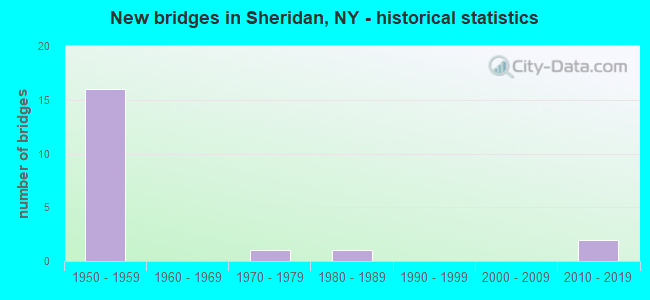
- New bridges - historical statistics
- 161950-1959
- 11970-1979
- 11980-1989
- 22010-2019

- Reconstructed bridges - Historical Statistics
- 31990-1999
- 12000-2009


- Bridge Condition - Deck
- 11.1%Excellent
- 44.4%Satisfactory
- 44.4%Fair

- Bridge Condition - Superstructure
- 10.0%Excellent
- 10.0%Good
- 30.0%Satisfactory
- 40.0%Fair
- 10.0%Poor

- Bridge Condition - Substructure
- 10.0%Very good
- 20.0%Good
- 40.0%Satisfactory
- 30.0%Fair

- Bridge Condition - Channel
- 14.3%Excellent
- 28.6%Good
- 28.6%Satisfactory
- 14.3%Fair
- 14.3%Poor

- Bridge Condition - Culverts
- 25.0%Excellent
- 25.0%Very good
- 25.0%Good
- 25.0%Satisfactory
Find on map >> Show street view
Structure Number: 100125, Location: 3.1 MI NE JCT RTS 5 + 60 (Lat: 42.510964, Lng: -79.277306), Route carried "on" structure: State highway 5, Year Built: 1954, Status: Open, Structure Length: 0.73m (2.40ft), Average Daily Traffic: 3,418 (year 2018), Truck Traffic: 8%, Average Future Daily Traffic: 3,434 (year 2040), Design Load: HS 20, Features Intersected: BEAVER CREEK
Minimum Vertical Clearance: 30+ m (98+ ft), Kilometerpoint: 50.024, Lanes on structure: 2, Base Highway Network: Yes, Owner: State Highway Agency, Approaching Roadway Width: 13.4m (44.0ft), Skew: 4 degrees, Material/Design: Concrete, Design/Construction: Culvert, Number Of Spans In Main Unit: 1, Length of Maximum Span: 7.0m (23.0ft)
Condition: Channel: Satisfactory, Culverts: Good, Operating Rating: 77.6 metric tons, Method Used To Determine Operating Rating: Field evaluation and documented engineering judgment, Inventory Rating: 32.7 metric tons, Method Used To Determine Inventory Rating: Field evaluation and documented engineering judgment, Structural Evaluation: Better than present minimum criteria, Waterway Adequacy: Somewhat better than minimum adequacy, Approach Roadway Alignment: Equal to present minimum criteria, Length Of Structure Improvement: 0.73m (2.40ft), Designated Inspection Frequency: Every 24 months, Inspection Date: July 2021, Bridge Improvement Cost: $271,000, Roadway Improvement Cost: $159,000, Total Project Cost: $430,000 ( Estimate for 2021)
Find on map >> Show street view
Structure Number: 101541, Location: JCT RT 20 + I-90 (Lat: 42.512419, Lng: -79.189189), Route carried "on" structure: US 20, Year Built: 1956, Year Reconstructed: 2014, Status: Open, Structure Length: 7.47m (24.51ft), Average Daily Traffic: 4,277 (year 2020), Truck Traffic: 6%, Average Future Daily Traffic: 4,317 (year 2040), Design Load: HS 20+Mod, Features Intersected: 90IX EB, RTE I90
Minimum Vertical Clearance: 30+ m (98+ ft), Kilometerpoint: 56.428, Lanes on structure: 2, Lanes under structure: 4, Base Highway Network: Yes, Owner: State Toll Authority, Approaching Roadway Width: 11.3m (37.1ft), Skew: 3 degrees, Material/Design: Steel continuous, Design/Construction: Stringer/Multi-beam, Number Of Spans In Main Unit: 4, Length of Maximum Span: 22.9m (75.1ft), Curb-To-Curb Width: 11.0m (36.1ft), Out-to-Out Width: 13.1m (43.0ft)
Condition: Deck: Satisfactory, Superstructure: Satisfactory, Substructure: Good, Operating Rating: 44.5 metric tons, Method Used To Determine Operating Rating: Load Factor (LF), Inventory Rating: 26.3 metric tons, Method Used To Determine Inventory Rating: Load Factor (LF), Structural Evaluation: Equal to present minimum criteria, Deck Geometry: Somewhat better than minimum adequacy, Underclear: High priority of corrective action, Approach Roadway Alignment: Equal to present minimum criteria, Length Of Structure Improvement: 7.46m (24.48ft), Designated Inspection Frequency: Every 24 months, Inspection Date: September 2021, Bridge Improvement Cost: $3,475,000, Roadway Improvement Cost: $2,035,000, Total Project Cost: $5,510,000 ( Estimate for 2021), Deck Structure Type: Concrete Cast-file-Place, Wearing Surface/Protective System: Wearing Surface: Monolithic Concrete
Find on map >> Show street view
Structure Number: 102441, Location: 0.2 MI E JCT RTS 20 + 39 (Lat: 42.467875, Lng: -79.271850), Route carried "on" structure: State highway 39, Year Built: 2018, Status: Open, Structure Length: 0.79m (2.59ft), Average Daily Traffic: 2,651 (year 2017), Truck Traffic: 9%, Average Future Daily Traffic: 2,796 (year 2040), Design Load: HL 93, Features Intersected: SCOTT CREEK
Minimum Vertical Clearance: 30+ m (98+ ft), Kilometerpoint: 0.290, Lanes on structure: 2, Base Highway Network: Yes, Owner: State Highway Agency, Approaching Roadway Width: 11.0m (36.1ft), Skew: 1 degrees, Material/Design: Concrete, Design/Construction: Culvert, Number Of Spans In Main Unit: 1, Length of Maximum Span: 7.3m (24.0ft), Curb-To-Curb Width: 11.0m (36.1ft), Out-to-Out Width: 12.0m (39.4ft)
Condition: Channel: Excellent, Culverts: Excellent, Operating Rating: 93.4 metric tons, Method Used To Determine Operating Rating: Load Factor (LF), Inventory Rating: 55.3 metric tons, Method Used To Determine Inventory Rating: Load Factor (LF), Structural Evaluation: Superior to present desirable criteria, Deck Geometry: Somewhat better than minimum adequacy, Waterway Adequacy: Meets minimum limits, Approach Roadway Alignment: Equal to present desirable criteria, Length Of Structure Improvement: 0.79m (2.59ft), Designated Inspection Frequency: Every 24 months, Inspection Date: October 2020, Bridge Improvement Cost: $467,000, Roadway Improvement Cost: $274,000, Total Project Cost: $741,000 ( Estimate for 2021)
Find on map >> Show street view
Structure Number: 109013, Location: 1.3 MI E JCT I-90 + 60 (Lat: 42.465156, Lng: -79.293928), Route carried "on" structure: County highway , Year Built: 1957, Status: Open, Structure Length: 6.89m (22.60ft), Average Daily Traffic: 2,528 (year 2020), Truck Traffic: 8%, Average Future Daily Traffic: 2,669 (year 2040), Design Load: HS 20+Mod, Features Intersected: 90IX EB, RTE I90, Facility Carried by Structure: COUNTY ROUTE 81
Minimum Vertical Clearance: 30+ m (98+ ft), Kilometerpoint: 0.837, Lanes on structure: 2, Lanes under structure: 4, Owner: State Toll Authority, Approaching Roadway Width: 7.3m (24.0ft), Material/Design: Steel, Design/Construction: Stringer/Multi-beam, Number Of Spans In Main Unit: 4, Length of Maximum Span: 22.6m (74.1ft), Curb or Sidewalk Widths: Left: 0.8m (2.6ft), Right: 0.8m (2.6ft), Curb-To-Curb Width: 11.0m (36.1ft), Out-to-Out Width: 13.1m (43.0ft)
Condition: Deck: Fair, Superstructure: Fair, Substructure: Fair, Operating Rating: 46.7 metric tons, Method Used To Determine Operating Rating: Load and Resistance Factor Rating (LRFR) rating reported by rating factor(RF) method using HL-93 loadings, Inventory Rating: 36.0 metric tons, Method Used To Determine Inventory Rating: Load and Resistance Factor Rating (LRFR) rating reported by rating factor(RF) method using HL-93 loadings, Structural Evaluation: Somewhat better than minimum adequacy, Deck Geometry: Somewhat better than minimum adequacy, Underclear: High priority of corrective action, Approach Roadway Alignment: Equal to present desirable criteria, Length Of Structure Improvement: 6.88m (22.57ft), Designated Inspection Frequency: Every 24 months, Inspection Date: September 2021, Bridge Improvement Cost: $3,216,000, Roadway Improvement Cost: $1,883,000, Total Project Cost: $5,099,000 ( Estimate for 2021), Deck Structure Type: Concrete Cast-file-Place, Wearing Surface/Protective System: Wearing Surface: Bituminous, Membrane: Other
Find on map >> Show street view
Structure Number: 33255, Location: 1.8 MI SW OF FORESTVILLE (Lat: 42.437653, Lng: -79.196881), Route carried "on" structure: County highway , Year Built: 2016, Status: Open, Structure Length: 2.16m (7.09ft), Average Daily Traffic: 460 (year 2018), Truck Traffic: 8%, Average Future Daily Traffic: 644 (year 2038), Design Load: HS 25 or greater, Features Intersected: WALNUT CREEK, Facility Carried by Structure: CREEK ROAD
Minimum Vertical Clearance: 30+ m (98+ ft), Kilometerpoint: 4.940, Lanes on structure: 2, Owner: County Highway Agency, Approaching Roadway Width: 6.1m (20.0ft), Skew: 2 degrees, Material/Design: Prestressed concrete, Design/Construction: Box Beam or Girders - Multiple, Number Of Spans In Main Unit: 1, Length of Maximum Span: 21.3m (69.9ft), Curb-To-Curb Width: 7.7m (25.3ft), Out-to-Out Width: 8.7m (28.5ft)
Condition: Deck: Excellent, Superstructure: Excellent, Substructure: Very good, Channel: Good, Operating Rating: 87.1 metric tons, Method Used To Determine Operating Rating: Load Factor (LF), Inventory Rating: 51.7 metric tons, Method Used To Determine Inventory Rating: Load Factor (LF), Structural Evaluation: Equal to present desirable criteria, Deck Geometry: Meets minimum limits, Waterway Adequacy: Meets minimum limits, Approach Roadway Alignment: Equal to present desirable criteria, Length Of Structure Improvement: 2.16m (7.09ft), Designated Inspection Frequency: Every 24 months, Inspection Date: November 2020, Bridge Improvement Cost: $770,000, Roadway Improvement Cost: $451,000, Total Project Cost: $1,222,000 ( Estimate for 2021), Wearing Surface/Protective System: Wearing Surface: Bituminous, Membrane: Other
Find on map >> Show street view
Structure Number: 332551, Location: 1.3 MI E OF DUNKIRK (Lat: 42.490075, Lng: -79.283578), Route carried "on" structure: County highway , Year Built: 1955, Status: Open, Structure Length: 1.01m (3.31ft), Average Daily Traffic: 724 (year 2020), Truck Traffic: 7%, Average Future Daily Traffic: 764 (year 2040), Design Load: HS 20, Features Intersected: SCOTT CREEK, Facility Carried by Structure: COUNTY ROAD 82
Minimum Vertical Clearance: 30+ m (98+ ft), Kilometerpoint: 1.931, Lanes on structure: 2, Owner: County Highway Agency, Approaching Roadway Width: 6.7m (22.0ft), Skew: 3 degrees, Material/Design: Concrete, Design/Construction: Slab, Number Of Spans In Main Unit: 1, Length of Maximum Span: 9.7m (31.8ft), Curb or Sidewalk Widths: Left: 0.7m (2.3ft), Right: 0.7m (2.3ft), Curb-To-Curb Width: 8.2m (26.9ft), Out-to-Out Width: 10.4m (34.1ft)
Condition: Deck: Fair, Superstructure: Fair, Substructure: Satisfactory, Channel: Fair, Operating Rating: 68.0 metric tons, Method Used To Determine Operating Rating: Load Factor (LF), Inventory Rating: 40.8 metric tons, Method Used To Determine Inventory Rating: Load Factor (LF), Structural Evaluation: Somewhat better than minimum adequacy, Deck Geometry: Somewhat better than minimum adequacy, Waterway Adequacy: Meets minimum limits, Approach Roadway Alignment: Meets minimum limits, Length Of Structure Improvement: 1.00m (3.28ft), Designated Inspection Frequency: Every 24 months, Inspection Date: March 2021, Bridge Improvement Cost: $367,000, Roadway Improvement Cost: $215,000, Total Project Cost: $582,000 ( Estimate for 2021), Wearing Surface/Protective System: Wearing Surface: Bituminous
Find on map >> Show street view
Structure Number: 332554, Location: 2.8 MI NORTH OF SHERIDAN (Lat: 42.528239, Lng: -79.237181), Route carried "on" structure: County highway , Year Built: 1977, Status: Open, Structure Length: 6.37m (20.90ft), Average Daily Traffic: 380 (year 2018), Truck Traffic: 8%, Average Future Daily Traffic: 470 (year 2040), Features Intersected: CSX TRANS/ AMTRAK, Facility Carried by Structure: COUNTY ROAD 91
Minimum Vertical Clearance: 30+ m (98+ ft), Kilometerpoint: 6.693, Lanes on structure: 2, Owner: County Highway Agency, Approaching Roadway Width: 6.1m (20.0ft), Skew: 2 degrees, Material/Design: Steel, Design/Construction: Stringer/Multi-beam, Number Of Spans In Main Unit: 3, Length of Maximum Span: 25.6m (84.0ft), Curb or Sidewalk Widths: Left: 0.9m (3.0ft), Right: 0.3m (1.0ft), Curb-To-Curb Width: 7.9m (25.9ft), Out-to-Out Width: 9.8m (32.2ft)
Condition: Deck: Fair, Superstructure: Fair, Substructure: Satisfactory, Operating Rating: 80.7 metric tons, Method Used To Determine Operating Rating: Load Factor (LF), Inventory Rating: 48.1 metric tons, Method Used To Determine Inventory Rating: Load Factor (LF), Structural Evaluation: Somewhat better than minimum adequacy, Deck Geometry: Somewhat better than minimum adequacy, Underclear: Better than present minimum criteria, Approach Roadway Alignment: Equal to present desirable criteria, Length Of Structure Improvement: 6.37m (20.90ft), Designated Inspection Frequency: Every 24 months, Inspection Date: October 2021, Bridge Improvement Cost: $2,281,000, Roadway Improvement Cost: $1,336,000, Total Project Cost: $3,616,000 ( Estimate for 2021), Deck Structure Type: Concrete Cast-file-Place, Wearing Surface/Protective System: Wearing Surface: Integral Concrete
Find on map >> Show street view
Structure Number: 336771, Location: 4 MI EAST OF DUNKIRK (Lat: 42.477422, Lng: -79.253711), Route carried "on" structure: County highway , Year Built: 1987, Status: Open, Structure Length: 0.73m (2.40ft), Average Daily Traffic: 498 (year 2016), Truck Traffic: 8%, Average Future Daily Traffic: 697 (year 2036), Features Intersected: BEAVER CREEK, Facility Carried by Structure: KING ROAD
Minimum Vertical Clearance: 30+ m (98+ ft), Kilometerpoint: 0.338, Lanes on structure: 2, Owner: County Highway Agency, Approaching Roadway Width: 6.7m (22.0ft), Skew: 4 degrees, Material/Design: Aluminum, Iron, Design/Construction: Culvert, Number Of Spans In Main Unit: 1, Length of Maximum Span: 6.1m (20.0ft)
Condition: Channel: Good, Culverts: Very good, Operating Rating: 76.9 metric tons, Method Used To Determine Operating Rating: Field evaluation and documented engineering judgment, Inventory Rating: 32.7 metric tons, Method Used To Determine Inventory Rating: Field evaluation and documented engineering judgment, Structural Evaluation: Equal to present desirable criteria, Waterway Adequacy: Somewhat better than minimum adequacy, Approach Roadway Alignment: Equal to present desirable criteria, Length Of Structure Improvement: 0.73m (2.40ft), Designated Inspection Frequency: Every 24 months, Inspection Date: April 2021, Bridge Improvement Cost: $136,000, Roadway Improvement Cost: $79,000, Total Project Cost: $215,000 ( Estimate for 2021)
Find on map >> Show street view
Structure Number: 551145, Location: 1.7 MI NE OF DUNKIRK INT (Lat: 42.472975, Lng: -79.278261), Route carried "on" structure: County highway , Year Built: 1956, Year Reconstructed: 1999, Status: Open, Structure Length: 7.68m (25.20ft), Average Daily Traffic: 747 (year 2016), Truck Traffic: 4%, Average Future Daily Traffic: 1,046 (year 2036), Design Load: HS 20+Mod, Features Intersected: 90IX EB, RTE I90, Facility Carried by Structure: CR 80 NEW ROAD
Minimum Vertical Clearance: 30+ m (98+ ft), Kilometerpoint: 1.335, Lanes on structure: 2, Lanes under structure: 4, Owner: State Toll Authority, Approaching Roadway Width: 6.4m (21.0ft), Skew: 3 degrees, Material/Design: Steel continuous, Design/Construction: Stringer/Multi-beam, Number Of Spans In Main Unit: 4, Length of Maximum Span: 22.6m (74.1ft), Curb or Sidewalk Widths: Left: 0.8m (2.6ft), Right: 0.8m (2.6ft), Curb-To-Curb Width: 8.0m (26.2ft), Out-to-Out Width: 10.1m (33.1ft)
Condition: Deck: Satisfactory, Superstructure: Poor, Substructure: Satisfactory, Operating Rating: 47.2 metric tons, Method Used To Determine Operating Rating: Load Factor (LF), Inventory Rating: 28.1 metric tons, Method Used To Determine Inventory Rating: Load Factor (LF), Structural Evaluation: Meets minimum limits, Deck Geometry: Somewhat better than minimum adequacy, Underclear: High priority of corrective action, Approach Roadway Alignment: Equal to present desirable criteria, Length Of Structure Improvement: 7.68m (25.20ft), Designated Inspection Frequency: Every 24 months, Inspection Date: October 2021, Bridge Improvement Cost: $2,715,000, Roadway Improvement Cost: $1,590,000, Total Project Cost: $4,306,000 ( Estimate for 2021), Deck Structure Type: Concrete Cast-file-Place, Wearing Surface/Protective System: Wearing Surface: Bituminous, Membrane: Other
Find on map >> Show street view
Structure Number: 551146, Location: 1.8 MI NE OF DUNKIRK INT (Lat: 42.473683, Lng: -79.276264), Route carried "on" structure: Interstate 90, Year Built: 1956, Year Reconstructed: 1995, Status: Open, Structure Length: 0.94m (3.08ft), Average Daily Traffic: 18,390 (year 2020), Truck Traffic: 40%, Average Future Daily Traffic: 20,609 (year 2040), Design Load: HS 20+Mod, Features Intersected: SCOTT CREEK
Minimum Vertical Clearance: 30+ m (98+ ft), Kilometerpoint: 48.318, Lanes on structure: 4, Base Highway Network: Yes, Toll: On Interstate toll segment, Owner: State Toll Authority, Approaching Roadway Width: 24.4m (80.1ft), Skew: 31 degrees, Material/Design: Concrete, Design/Construction: Culvert, Number Of Spans In Main Unit: 2, Length of Maximum Span: 4.6m (15.1ft)
Condition: Channel: Satisfactory, Culverts: Satisfactory, Inventory Rating: 61.7 metric tons, Method Used To Determine Inventory Rating: Load Factor (LF), Structural Evaluation: Equal to present minimum criteria, Waterway Adequacy: Meets minimum limits, Approach Roadway Alignment: Equal to present desirable criteria, Length Of Structure Improvement: 0.94m (3.08ft), Designated Inspection Frequency: Every 24 months, Inspection Date: July 2021, Bridge Improvement Cost: $1,068,000, Roadway Improvement Cost: $626,000, Total Project Cost: $1,694,000 ( Estimate for 2021)
Find on map >> Show street view
Structure Number: 551147, Location: 2.4 MI NE OF DUNKIRK INT (Lat: 42.478769, Lng: -79.265731), Route carried "on" structure: Other road , Year Built: 1954, Status: Open, Structure Length: 7.56m (24.80ft), Average Daily Traffic: 222 (year 2017), Truck Traffic: 3%, Average Future Daily Traffic: 311 (year 2037), Design Load: HS 20+Mod, Features Intersected: 90IX EB, RTE I90, Facility Carried by Structure: NEWELL RD
Minimum Vertical Clearance: 30+ m (98+ ft), Kilometerpoint: 0.547, Lanes on structure: 2, Lanes under structure: 4, Owner: State Toll Authority, Approaching Roadway Width: 6.1m (20.0ft), Skew: 3 degrees, Material/Design: Steel continuous, Design/Construction: Stringer/Multi-beam, Number Of Spans In Main Unit: 4, Length of Maximum Span: 23.2m (76.1ft), Curb or Sidewalk Widths: Left: 0.8m (2.6ft), Right: 0.8m (2.6ft), Curb-To-Curb Width: 7.9m (25.9ft), Out-to-Out Width: 10.1m (33.1ft)
Condition: Deck: Satisfactory, Superstructure: Satisfactory, Substructure: Satisfactory, Operating Rating: 39.0 metric tons, Method Used To Determine Operating Rating: Load Factor (LF), Inventory Rating: 23.6 metric tons, Method Used To Determine Inventory Rating: Load Factor (LF), Structural Evaluation: Equal to present minimum criteria, Deck Geometry: Somewhat better than minimum adequacy, Underclear: High priority of corrective action, Approach Roadway Alignment: Equal to present desirable criteria, Length Of Structure Improvement: 7.55m (24.77ft), Designated Inspection Frequency: Every 24 months, Inspection Date: October 2021, Bridge Improvement Cost: $2,681,000, Roadway Improvement Cost: $1,570,000, Total Project Cost: $4,251,000 ( Estimate for 2021), Deck Structure Type: Concrete Cast-file-Place, Wearing Surface/Protective System: Wearing Surface: Bituminous, Membrane: Other
Find on map >> Show street view
Structure Number: 551148, Location: 3.2 MI NE OF DUNKIRK INT (Lat: 42.486417, Lng: -79.253058), Route carried "on" structure: Interstate 90, Year Built: 1954, Status: Open, Structure Length: 1.13m (3.71ft), Average Daily Traffic: 18,390 (year 2020), Truck Traffic: 40%, Average Future Daily Traffic: 20,609 (year 2040), Design Load: HS 20+Mod, Features Intersected: BEAVER CREEK
Minimum Vertical Clearance: 30+ m (98+ ft), Kilometerpoint: 50.700, Lanes on structure: 4, Base Highway Network: Yes, Toll: On Interstate toll segment, Owner: State Toll Authority, Approaching Roadway Width: 28.0m (91.9ft), Skew: 23 degrees, Material/Design: Concrete, Design/Construction: Frame, Number Of Spans In Main Unit: 2, Length of Maximum Span: 4.9m (16.1ft), Curb-To-Curb Width: 36.9m (121.1ft), Out-to-Out Width: 45.1m (148.0ft)
Condition: Superstructure: Fair, Substructure: Fair, Channel: Poor, Structural Evaluation: Somewhat better than minimum adequacy, Deck Geometry: Superior to present desirable criteria, Waterway Adequacy: Meets minimum limits, Approach Roadway Alignment: Equal to present desirable criteria, Length Of Structure Improvement: 1.12m (3.67ft), Designated Inspection Frequency: Every 24 months, Inspection Date: July 2021, Bridge Improvement Cost: $2,807,000, Roadway Improvement Cost: $1,644,000, Total Project Cost: $4,451,000 ( Estimate for 2021)
Find on map >> Show street view
Structure Number: 551149, Location: 4.3 MI NE OF DUNKIRK INT (Lat: 42.496658, Lng: -79.236908), Route carried "on" structure: County highway , Year Built: 1954, Status: Closed, Structure Length: 7.71m (25.30ft), Average Daily Traffic: 888 (year 2020), Truck Traffic: 9%, Average Future Daily Traffic: 1,098 (year 2040), Design Load: HS 20+Mod, Features Intersected: 90IX, RTE I90, Facility Carried by Structure: CR 79 Center Rd
Minimum Vertical Clearance: 30+ m (98+ ft), Kilometerpoint: 3.170, Lanes on structure: 2, Lanes under structure: 4, Owner: State Toll Authority, Approaching Roadway Width: 7.0m (23.0ft), Skew: 3 degrees, Material/Design: Steel continuous, Design/Construction: Stringer/Multi-beam, Number Of Spans In Main Unit: 4, Length of Maximum Span: 23.8m (78.1ft), Curb or Sidewalk Widths: Left: 0.8m (2.6ft), Right: 0.8m (2.6ft), Curb-To-Curb Width: 7.9m (25.9ft), Out-to-Out Width: 10.1m (33.1ft)
Condition: Deck: Satisfactory, Superstructure: Good, Substructure: Good, Deck Geometry: Somewhat better than minimum adequacy, Approach Roadway Alignment: Equal to present desirable criteria, Bridge Posting: Required (Relationship of Operating Rating to Maximum Legal Load: > 39.9% below), Length Of Structure Improvement: 7.71m (25.30ft), Designated Inspection Frequency: Every 24 months, Inspection Date: September 2021, Bridge Improvement Cost: $2,736,000, Roadway Improvement Cost: $1,602,000, Total Project Cost: $4,339,000 ( Estimate for 2021), Deck Structure Type: Concrete Cast-file-Place, Wearing Surface/Protective System: Wearing Surface: Bituminous, Membrane: Other
Find on map >> Show street view
Structure Number: 55115, Location: 4.9 MI NE OF DUNKIRK INT (Lat: 42.501231, Lng: -79.226161), Route carried "on" structure: Other road , Year Built: 1956, Year Reconstructed: 1999, Status: Open, Structure Length: 7.22m (23.69ft), Average Daily Traffic: 58 (year 2017), Truck Traffic: 9%, Average Future Daily Traffic: 81 (year 2037), Design Load: HS 20+Mod, Features Intersected: 90IX EB, RTE I90, Facility Carried by Structure: O'BRIEN RD
Minimum Vertical Clearance: 30+ m (98+ ft), Kilometerpoint: 0.724, Lanes on structure: 2, Lanes under structure: 4, Owner: State Toll Authority, Approaching Roadway Width: 6.1m (20.0ft), Skew: 2 degrees, Material/Design: Steel continuous, Design/Construction: Stringer/Multi-beam, Number Of Spans In Main Unit: 4, Length of Maximum Span: 21.9m (71.9ft), Curb or Sidewalk Widths: Left: 0.8m (2.6ft), Right: 0.8m (2.6ft), Curb-To-Curb Width: 7.9m (25.9ft), Out-to-Out Width: 10.1m (33.1ft)
Condition: Deck: Fair, Superstructure: Satisfactory, Substructure: Fair, Operating Rating: 65.3 metric tons, Method Used To Determine Operating Rating: Load Factor (LF), Inventory Rating: 39.0 metric tons, Method Used To Determine Inventory Rating: Load Factor (LF), Structural Evaluation: Somewhat better than minimum adequacy, Deck Geometry: Equal to present minimum criteria, Underclear: High priority of corrective action, Approach Roadway Alignment: Equal to present desirable criteria, Length Of Structure Improvement: 7.22m (23.69ft), Designated Inspection Frequency: Every 24 months, Inspection Date: September 2021, Bridge Improvement Cost: $2,561,000, Roadway Improvement Cost: $1,500,000, Total Project Cost: $4,061,000 ( Estimate for 2021), Deck Structure Type: Concrete Cast-file-Place, Wearing Surface/Protective System: Wearing Surface: Bituminous, Membrane: Other
Find on map >> Show street view
Structure Number: 101541, Location: JCT RT 20 + I-90 (Lat: 42.512419, Lng: -79.189189), Route carried "under" structure: Interstate 90, Year Built: 1956, Structure Length: 0. m, Average Daily Traffic: 12,300 (year 1975), Features Intersected: 90IX EB, RTE I90, Facility Carried by Structure: RTE 20
Minimum Vertical Clearance: 4.34m (14.24ft), Kilometerpoint: 741.331, Lanes on structure: 2, Lanes under structure: 2, Toll: On Interstate toll segment, Material/Design: Steel continuous, Design/Construction: Stringer/Multi-beam, Length of Maximum Span: 22.9m (75.1ft)
Find on map >> Show street view
Structure Number: 109013, Location: 1.3 MI E JCT I-90 + 60 (Lat: 42.465156, Lng: -79.293928), Route carried "under" structure: Interstate 90, Year Built: 1957, Structure Length: 0. m, Average Daily Traffic: 13,300 (year 1973), Features Intersected: 90IX EB, RTE I90, Facility Carried by Structure: COUNTY ROUTE 81
Minimum Vertical Clearance: 4.45m (14.60ft), Kilometerpoint: 751.580, Lanes on structure: 2, Lanes under structure: 2, Toll: On Interstate toll segment, Material/Design: Steel, Design/Construction: Stringer/Multi-beam, Length of Maximum Span: 22.6m (74.1ft)
Find on map >> Show street view
Structure Number: 551145, Location: 1.7 MI NE OF DUNKIRK INT (Lat: 42.472975, Lng: -79.278261), Route carried "under" structure: Interstate 90, Year Built: 1956, Structure Length: 0. m, Average Daily Traffic: 12,900 (year 1977), Features Intersected: 90IX EB, RTE I90, Facility Carried by Structure: CR 80 NEW ROAD
Minimum Vertical Clearance: 4.37m (14.34ft), Kilometerpoint: 750.003, Lanes on structure: 2, Lanes under structure: 2, Toll: On Interstate toll segment, Material/Design: Steel continuous, Design/Construction: Stringer/Multi-beam, Length of Maximum Span: 22.6m (74.1ft)
Find on map >> Show street view
Structure Number: 551147, Location: 2.4 MI NE OF DUNKIRK INT (Lat: 42.478769, Lng: -79.265731), Route carried "under" structure: Interstate 90, Year Built: 1954, Structure Length: 0. m, Average Daily Traffic: 12,900 (year 1977), Features Intersected: 90IX EB, RTE I90, Facility Carried by Structure: NEWELL RD
Minimum Vertical Clearance: 4.42m (14.50ft), Kilometerpoint: 748.796, Lanes on structure: 2, Lanes under structure: 2, Toll: On Interstate toll segment, Material/Design: Steel continuous, Design/Construction: Stringer/Multi-beam, Length of Maximum Span: 23.2m (76.1ft)
Find on map >> Show street view
Structure Number: 551149, Location: 4.3 MI NE OF DUNKIRK INT (Lat: 42.496658, Lng: -79.236908), Route carried "under" structure: Interstate 90, Year Built: 1954, Structure Length: 0. m, Average Daily Traffic: 12,900 (year 1977), Features Intersected: 90IX, RTE I90, Facility Carried by Structure: CR 79 Center Rd
Minimum Vertical Clearance: 4.45m (14.60ft), Kilometerpoint: 745.691, Lanes on structure: 2, Lanes under structure: 2, Toll: On Interstate toll segment, Material/Design: Steel continuous, Design/Construction: Stringer/Multi-beam, Length of Maximum Span: 23.8m (78.1ft)
Find on map >> Show street view
Structure Number: 55115, Location: 4.9 MI NE OF DUNKIRK INT (Lat: 42.501231, Lng: -79.226161), Route carried "under" structure: Interstate 90, Year Built: 1956, Structure Length: 0. m, Average Daily Traffic: 12,900 (year 1977), Features Intersected: 90IX EB, RTE I90, Facility Carried by Structure: O'BRIEN RD
Minimum Vertical Clearance: 4.45m (14.60ft), Kilometerpoint: 744.677, Lanes on structure: 2, Lanes under structure: 2, Toll: On Interstate toll segment, Material/Design: Steel continuous, Design/Construction: Stringer/Multi-beam, Length of Maximum Span: 21.9m (71.9ft)