Bridge Statistics for Sheldon, New York (NY)
Condition, Traffic, Stress, Structural Evaluation, Project Costs
- National Bridge Inventory (NBI) Statistics
- 15Number of bridges
- 69ft / 21.2mTotal length
- $13,917,000Total costs
- 16,352Total average daily traffic
- 1,508Total average daily truck traffic
- 18,352Total future (year 2036) average daily traffic
- National Bridge Inventory (NBI) Registered Bridges for Sheldon
- No street view available for this location
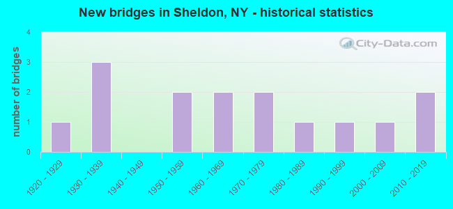
- New bridges - historical statistics
- 11920-1929
- 31930-1939
- 21950-1959
- 21960-1969
- 21970-1979
- 11980-1989
- 11990-1999
- 12000-2009
- 22010-2019

- Reconstructed bridges - Historical Statistics
- 11980-1989
- 01990-1999
- 12000-2009


- Bridge Condition - Deck
- 12.5%Excellent
- 12.5%Very good
- 12.5%Good
- 25.0%Satisfactory
- 37.5%Fair

- Bridge Condition - Superstructure
- 44.4%Good
- 33.3%Fair
- 22.2%Poor

- Bridge Condition - Substructure
- 11.1%Good
- 44.4%Satisfactory
- 44.4%Fair

- Bridge Condition - Channel
- 6.7%Very good
- 20.0%Good
- 53.3%Satisfactory
- 13.3%Fair
- 6.7%Poor

- Bridge Condition - Culverts
- 50.0%Very good
- 16.7%Good
- 33.3%Satisfactory
Find on map >> Show street view
Structure Number: 101612, Location: .7 MI E JCT US 20A & SH77 (Lat: 42.771000, Lng: -78.375542), Route carried "on" structure: US 20A, Year Built: 1928, Status: Open, Structure Length: 1.19m (3.90ft), Average Daily Traffic: 3,609 (year 2017), Truck Traffic: 9%, Average Future Daily Traffic: 3,631 (year 2040), Features Intersected: CAYUGA CREEK
Minimum Vertical Clearance: 30+ m (98+ ft), Kilometerpoint: 7.208, Lanes on structure: 2, Base Highway Network: Yes, Owner: State Highway Agency, Approaching Roadway Width: 10.4m (34.1ft), Material/Design: Steel, Design/Construction: Stringer/Multi-beam, Number Of Spans In Main Unit: 1, Length of Maximum Span: 11.3m (37.1ft), Curb-To-Curb Width: 9.1m (29.9ft), Out-to-Out Width: 10.0m (32.8ft)
Condition: Deck: Fair, Superstructure: Fair, Substructure: Fair, Channel: Satisfactory, Operating Rating: 90.7 metric tons, Method Used To Determine Operating Rating: Load Factor (LF), Inventory Rating: 54.4 metric tons, Method Used To Determine Inventory Rating: Load Factor (LF), Structural Evaluation: Somewhat better than minimum adequacy, Deck Geometry: Meets minimum limits, Waterway Adequacy: Equal to present minimum criteria, Approach Roadway Alignment: Meets minimum limits, Length Of Structure Improvement: 1.18m (3.87ft), Designated Inspection Frequency: Every 24 months, Inspection Date: July 2020, Bridge Improvement Cost: $617,000, Roadway Improvement Cost: $361,000, Total Project Cost: $978,000 ( Estimate for 2021), Deck Structure Type: Concrete Cast-file-Place, Wearing Surface/Protective System: Wearing Surface: Bituminous
Find on map >> Show street view
Structure Number: 101613, Location: 0.1 MI W JCT RTS 20A + 98 (Lat: 42.763339, Lng: -78.314331), Route carried "on" structure: US 20A, Year Built: 1985, Status: Open, Structure Length: 3.41m (11.19ft), Average Daily Traffic: 3,609 (year 2017), Truck Traffic: 9%, Average Future Daily Traffic: 3,631 (year 2040), Design Load: HS 20, Features Intersected: TONAWANDA CREEK
Minimum Vertical Clearance: 30+ m (98+ ft), Kilometerpoint: 12.872, Lanes on structure: 2, Base Highway Network: Yes, Owner: State Highway Agency, Approaching Roadway Width: 10.4m (34.1ft), Skew: 2 degrees, Material/Design: Prestressed concrete, Design/Construction: Box Beam or Girders - Multiple, Number Of Spans In Main Unit: 1, Length of Maximum Span: 32.6m (107.0ft), Curb-To-Curb Width: 10.4m (34.1ft), Out-to-Out Width: 11.3m (37.1ft)
Condition: Deck: Satisfactory, Superstructure: Good, Substructure: Satisfactory, Channel: Satisfactory, Operating Rating: 91.6 metric tons, Method Used To Determine Operating Rating: Load Factor (LF), Inventory Rating: 44.5 metric tons, Method Used To Determine Inventory Rating: Load Factor (LF), Structural Evaluation: Equal to present minimum criteria, Deck Geometry: Somewhat better than minimum adequacy, Waterway Adequacy: Superior to present desirable criteria, Approach Roadway Alignment: Equal to present desirable criteria, Length Of Structure Improvement: 3.41m (11.19ft), Designated Inspection Frequency: Every 24 months, Inspection Date: June 2020, Bridge Improvement Cost: $1,013,000, Roadway Improvement Cost: $593,000, Total Project Cost: $1,606,000 ( Estimate for 2021), Deck Structure Type: Concrete Cast-file-Place, Wearing Surface/Protective System: Wearing Surface: Bituminous, Membrane: Other, Deck Protection: Epoxy Coated Reinforcing
Find on map >> Show street view
Structure Number: 101614, Location: 0.2MI S JCT RTS 98 + 20A (Lat: 42.759742, Lng: -78.311308), Route carried "on" structure: US 20A, Year Built: 1931, Year Reconstructed: 2012, Status: Open, Structure Length: 1.68m (5.51ft), Average Daily Traffic: 4,308 (year 2017), Truck Traffic: 9%, Average Future Daily Traffic: 4,334 (year 2040), Design Load: HS 25 or greater, Features Intersected: STONY BROOK
Minimum Vertical Clearance: 30+ m (98+ ft), Kilometerpoint: 13.355, Lanes on structure: 2, Base Highway Network: Yes, Owner: State Highway Agency, Approaching Roadway Width: 10.4m (34.1ft), Skew: 3 degrees, Material/Design: Steel, Design/Construction: Stringer/Multi-beam, Number Of Spans In Main Unit: 1, Length of Maximum Span: 16.1m (52.8ft), Curb-To-Curb Width: 10.4m (34.1ft), Out-to-Out Width: 11.8m (38.7ft)
Condition: Deck: Excellent, Superstructure: Poor, Substructure: Fair, Channel: Poor, Operating Rating: 51.7 metric tons, Method Used To Determine Operating Rating: Load Factor (LF), Inventory Rating: 30.8 metric tons, Method Used To Determine Inventory Rating: Load Factor (LF), Structural Evaluation: Meets minimum limits, Deck Geometry: Somewhat better than minimum adequacy, Waterway Adequacy: Equal to present minimum criteria, Approach Roadway Alignment: Equal to present desirable criteria, Length Of Structure Improvement: 1.67m (5.48ft), Designated Inspection Frequency: Every 24 months, Inspection Date: August 2021, Bridge Improvement Cost: $967,000, Roadway Improvement Cost: $566,000, Total Project Cost: $1,533,000 ( Estimate for 2021), Deck Structure Type: Concrete Cast-file-Place, Wearing Surface/Protective System: Wearing Surface: Integral Concrete, Deck Protection: Epoxy Coated Reinforcing
Find on map >> Show street view
Structure Number: 103565, Location: 3.4MI S JCT RTS 98 + 20A (Lat: 42.711931, Lng: -78.330639), Route carried "on" structure: State highway 98, Year Built: 1931, Status: Open, Structure Length: 1.07m (3.51ft), Average Daily Traffic: 1,046 (year 2016), Truck Traffic: 12%, Average Future Daily Traffic: 1,464 (year 2036), Design Load: Pedestrian, Features Intersected: EAST FORK
Minimum Vertical Clearance: 30+ m (98+ ft), Kilometerpoint: 27.546, Lanes on structure: 2, Base Highway Network: Yes, Owner: State Highway Agency, Approaching Roadway Width: 11.6m (38.1ft), Skew: 4 degrees, Material/Design: Concrete, Design/Construction: Culvert, Number Of Spans In Main Unit: 1, Length of Maximum Span: 9.1m (29.9ft)
Condition: Channel: Satisfactory, Culverts: Satisfactory, Operating Rating: 46.0 metric tons, Method Used To Determine Operating Rating: Load and Resistance Factor Rating (LRFR) rating reported by rating factor(RF) method using HL-93 loadings, Inventory Rating: 35.6 metric tons, Method Used To Determine Inventory Rating: Load and Resistance Factor Rating (LRFR) rating reported by rating factor(RF) method using HL-93 loadings, Structural Evaluation: Equal to present minimum criteria, Waterway Adequacy: Better than present minimum criteria, Approach Roadway Alignment: Somewhat better than minimum adequacy, Length Of Structure Improvement: 1.06m (3.48ft), Designated Inspection Frequency: Every 24 months, Inspection Date: June 2020, Bridge Improvement Cost: $665,000, Roadway Improvement Cost: $389,000, Total Project Cost: $1,054,000 ( Estimate for 2021), Wearing Surface/Protective System: Wearing Surface: Bituminous
Find on map >> Show street view
Structure Number: 103566, Location: 2.8MI S JCT RTS 98 + 20A (Lat: 42.718139, Lng: -78.322058), Route carried "on" structure: State highway 98, Year Built: 1931, Status: Open, Structure Length: 1.49m (4.89ft), Average Daily Traffic: 1,046 (year 2016), Truck Traffic: 12%, Average Future Daily Traffic: 1,464 (year 2036), Features Intersected: TONAWANDA CREEK
Minimum Vertical Clearance: 30+ m (98+ ft), Kilometerpoint: 28.544, Lanes on structure: 2, Base Highway Network: Yes, Owner: State Highway Agency, Approaching Roadway Width: 11.6m (38.1ft), Skew: 1 degrees, Material/Design: Steel, Design/Construction: Stringer/Multi-beam, Number Of Spans In Main Unit: 1, Length of Maximum Span: 14.3m (46.9ft), Curb-To-Curb Width: 7.9m (25.9ft), Out-to-Out Width: 8.7m (28.5ft)
Condition: Deck: Fair, Superstructure: Poor, Substructure: Satisfactory, Channel: Good, Operating Rating: 37.2 metric tons, Method Used To Determine Operating Rating: Load Factor (LF), Inventory Rating: 21.8 metric tons, Method Used To Determine Inventory Rating: Load Factor (LF), Structural Evaluation: Meets minimum limits, Deck Geometry: Meets minimum limits, Waterway Adequacy: Better than present minimum criteria, Approach Roadway Alignment: Somewhat better than minimum adequacy, Length Of Structure Improvement: 1.49m (4.89ft), Designated Inspection Frequency: Every 24 months, Inspection Date: September 2020, Bridge Improvement Cost: $528,000, Roadway Improvement Cost: $309,000, Total Project Cost: $837,000 ( Estimate for 2021), Deck Structure Type: Concrete Cast-file-Place, Wearing Surface/Protective System: Wearing Surface: Bituminous
Find on map >> Show street view
Structure Number: 332016, Location: 6.2 MI S FOLSOMDALE (Lat: 42.737083, Lng: -78.440842), Route carried "on" structure: County highway , Year Built: 1973, Status: Open, Structure Length: 0.70m (2.30ft), Average Daily Traffic: 491 (year 2018), Truck Traffic: 9%, Average Future Daily Traffic: 687 (year 2038), Design Load: HS 20, Features Intersected: SHELDON CREEK, Facility Carried by Structure: CENTERLINE ROAD
Minimum Vertical Clearance: 30+ m (98+ ft), Kilometerpoint: 0.274, Lanes on structure: 2, Owner: County Highway Agency, Approaching Roadway Width: 8.5m (27.9ft), Skew: 1 degrees, Material/Design: Concrete continuous, Design/Construction: Culvert, Number Of Spans In Main Unit: 2, Length of Maximum Span: 3.4m (11.2ft)
Condition: Channel: Fair, Culverts: Very good, Inventory Rating: 80.7 metric tons, Method Used To Determine Inventory Rating: Load Factor (LF), Structural Evaluation: Equal to present desirable criteria, Waterway Adequacy: Meets minimum limits, Approach Roadway Alignment: Equal to present desirable criteria, Length Of Structure Improvement: 0.70m (2.30ft), Designated Inspection Frequency: Every 24 months, Inspection Date: November 2020, Bridge Improvement Cost: $107,000, Roadway Improvement Cost: $63,000, Total Project Cost: $170,000 ( Estimate for 2021)
Find on map >> Show street view
Structure Number: 332017, Location: 1.0 MI N STRYKERSVILLE (Lat: 42.708653, Lng: -78.448208), Route carried "on" structure: Alternate County highway , Year Built: 2012, Status: Open, Structure Length: 1.37m (4.49ft), Average Daily Traffic: 924 (year 2020), Truck Traffic: 12%, Average Future Daily Traffic: 1,294 (year 2040), Design Load: HL 93, Features Intersected: GLADE CREEK, Facility Carried by Structure: DUTCH HOLLOW ROAD
Minimum Vertical Clearance: 30+ m (98+ ft), Kilometerpoint: 0.418, Lanes on structure: 2, Owner: County Highway Agency, Approaching Roadway Width: 9.8m (32.2ft), Skew: 4 degrees, Material/Design: Concrete, Design/Construction: Culvert, Number Of Spans In Main Unit: 1, Length of Maximum Span: 13.1m (43.0ft)
Condition: Channel: Good, Culverts: Very good, Operating Rating: 81.9 metric tons, Method Used To Determine Operating Rating: Field evaluation and documented engineering judgment, Inventory Rating: 40.8 metric tons, Method Used To Determine Inventory Rating: Field evaluation and documented engineering judgment, Structural Evaluation: Equal to present desirable criteria, Waterway Adequacy: Equal to present minimum criteria, Approach Roadway Alignment: Equal to present minimum criteria, Length Of Structure Improvement: 1.37m (4.49ft), Designated Inspection Frequency: Every 24 months, Inspection Date: October 2020, Bridge Improvement Cost: $642,000, Roadway Improvement Cost: $376,000, Total Project Cost: $1,017,000 ( Estimate for 2021)
Find on map >> Show street view
Structure Number: 332018, Location: 0.6 MI NW STRYKERSVILLE (Lat: 42.702089, Lng: -78.456017), Route carried "on" structure: Other road , Year Built: 1963, Year Reconstructed: 1991, Status: Open, Structure Length: 2.96m (9.71ft), Average Daily Traffic: 303 (year 2020), Truck Traffic: 5%, Average Future Daily Traffic: 424 (year 2040), Design Load: H 15, Features Intersected: BUFFALO CREEK, Facility Carried by Structure: FACTORY ROAD
Minimum Vertical Clearance: 30+ m (98+ ft), Kilometerpoint: 0.740, Lanes on structure: 2, Owner: County Highway Agency, Approaching Roadway Width: 7.0m (23.0ft), Material/Design: Steel, Design/Construction: Truss - Thru, Number Of Spans In Main Unit: 1, Length of Maximum Span: 28.0m (91.9ft), Curb-To-Curb Width: 7.0m (23.0ft), Out-to-Out Width: 7.7m (25.3ft)
Condition: Deck: Very good, Superstructure: Good, Substructure: Fair, Channel: Fair, Operating Rating: 58.1 metric tons, Method Used To Determine Operating Rating: Load Factor (LF), Inventory Rating: 34.5 metric tons, Method Used To Determine Inventory Rating: Load Factor (LF), Structural Evaluation: Somewhat better than minimum adequacy, Deck Geometry: Meets minimum limits, Waterway Adequacy: Better than present minimum criteria, Approach Roadway Alignment: Equal to present desirable criteria, Length Of Structure Improvement: 2.95m (9.68ft), Designated Inspection Frequency: Every 24 months, Critical Feature Inspection Frequency: Every 24 months, Inspection Date: July 2020, Critical Feature Inspection Date: July 2020, Bridge Improvement Cost: $1,910,000, Roadway Improvement Cost: $1,119,000, Total Project Cost: $3,029,000 ( Estimate for 2021), Deck Structure Type: Wood or Timber, Wearing Surface/Protective System: Wearing Surface: Bituminous, Membrane: Other
Find on map >> Show street view
Structure Number: 332019, Location: 0.1 MI W STRYKERSVILLE (Lat: 42.695144, Lng: -78.450322), Route carried "on" structure: Other road , Year Built: 1978, Status: Open, Structure Length: 2.53m (8.30ft), Average Daily Traffic: 258 (year 2018), Truck Traffic: 4%, Average Future Daily Traffic: 361 (year 2038), Design Load: HS 20, Features Intersected: BUFFALO CREEK, Facility Carried by Structure: SANDERS ROAD
Minimum Vertical Clearance: 30+ m (98+ ft), Kilometerpoint: 0.129, Lanes on structure: 2, Owner: County Highway Agency, Approaching Roadway Width: 7.3m (24.0ft), Skew: 2 degrees, Material/Design: Wood or Timber, Design/Construction: Stringer/Multi-beam, Number Of Spans In Main Unit: 1, Length of Maximum Span: 24.4m (80.1ft), Curb-To-Curb Width: 8.5m (27.9ft), Out-to-Out Width: 9.1m (29.9ft)
Condition: Deck: Good, Superstructure: Good, Substructure: Good, Channel: Satisfactory, Operating Rating: 62.6 metric tons, Method Used To Determine Operating Rating: Allowable Stress (AS), Inventory Rating: 41.7 metric tons, Method Used To Determine Inventory Rating: Allowable Stress (AS), Structural Evaluation: Better than present minimum criteria, Deck Geometry: Equal to present minimum criteria, Waterway Adequacy: Better than present minimum criteria, Approach Roadway Alignment: Better than present minimum criteria, Length Of Structure Improvement: 2.52m (8.27ft), Designated Inspection Frequency: Every 24 months, Inspection Date: October 2020, Bridge Improvement Cost: $957,000, Roadway Improvement Cost: $560,000, Total Project Cost: $1,517,000 ( Estimate for 2021), Deck Structure Type: Wood or Timber, Wearing Surface/Protective System: Wearing Surface: Bituminous, Membrane: Other
Find on map >> Show street view
Structure Number: 33202, Location: 2.0 MI NE OF NORTH JAVA (Lat: 42.704703, Lng: -78.311931), Route carried "on" structure: Other road , Year Built: 2001, Status: Open, Structure Length: 0.82m (2.69ft), Average Daily Traffic: 100 (year 2018), Truck Traffic: 5%, Average Future Daily Traffic: 140 (year 2038), Design Load: HS 25 or greater, Features Intersected: E FK TONAWANDA CK, Facility Carried by Structure: ALMETER ROAD
Minimum Vertical Clearance: 30+ m (98+ ft), Kilometerpoint: 0.306, Lanes on structure: 2, Owner: County Highway Agency, Approaching Roadway Width: 9.1m (29.9ft), Material/Design: Concrete, Design/Construction: Culvert, Number Of Spans In Main Unit: 1, Length of Maximum Span: 7.6m (24.9ft)
Condition: Channel: Good, Culverts: Satisfactory, Operating Rating: 78.0 metric tons, Method Used To Determine Operating Rating: Field evaluation and documented engineering judgment, Inventory Rating: 40.8 metric tons, Method Used To Determine Inventory Rating: Field evaluation and documented engineering judgment, Structural Evaluation: Equal to present minimum criteria, Waterway Adequacy: Better than present minimum criteria, Approach Roadway Alignment: Equal to present desirable criteria, Length Of Structure Improvement: 0.82m (2.69ft), Designated Inspection Frequency: Every 24 months, Inspection Date: May 2021, Bridge Improvement Cost: $135,000, Roadway Improvement Cost: $79,000, Total Project Cost: $214,000 ( Estimate for 2021)
Find on map >> Show street view
Structure Number: 332021, Location: 1.5 MI NW OF NORTH JAVA (Lat: 42.705022, Lng: -78.346664), Route carried "on" structure: Other road , Year Built: 1952, Status: Open, Structure Length: 0.82m (2.69ft), Average Daily Traffic: 154 (year 2018), Truck Traffic: 13%, Average Future Daily Traffic: 216 (year 2038), Design Load: H 15, Features Intersected: TONAWANDA CREEK, Facility Carried by Structure: ALMETER ROAD
Minimum Vertical Clearance: 30+ m (98+ ft), Kilometerpoint: 3.315, Lanes on structure: 2, Owner: County Highway Agency, Approaching Roadway Width: 5.5m (18.0ft), Skew: 1 degrees, Material/Design: Prestressed concrete, Design/Construction: Stringer/Multi-beam, Number Of Spans In Main Unit: 1, Length of Maximum Span: 7.6m (24.9ft), Curb-To-Curb Width: 6.4m (21.0ft), Out-to-Out Width: 7.0m (23.0ft)
Condition: Deck: Fair, Superstructure: Fair, Substructure: Satisfactory, Channel: Satisfactory, Operating Rating: 50.6 metric tons, Method Used To Determine Operating Rating: Field evaluation and documented engineering judgment, Inventory Rating: 21.2 metric tons, Method Used To Determine Inventory Rating: Field evaluation and documented engineering judgment, Structural Evaluation: Somewhat better than minimum adequacy, Deck Geometry: Meets minimum limits, Waterway Adequacy: Equal to present desirable criteria, Approach Roadway Alignment: Equal to present desirable criteria, Length Of Structure Improvement: 0.82m (2.69ft), Designated Inspection Frequency: Every 24 months, Inspection Date: April 2020, Bridge Improvement Cost: $228,000, Roadway Improvement Cost: $133,000, Total Project Cost: $361,000 ( Estimate for 2021), Wearing Surface/Protective System: Wearing Surface: Bituminous, Membrane: Preformed Fabric
Find on map >> Show street view
Structure Number: 332022, Location: 1.8 MI NE NORTH JAVA (Lat: 42.698281, Lng: -78.308072), Route carried "on" structure: Other road , Year Built: 1960, Status: Open, Structure Length: 0.85m (2.79ft), Average Daily Traffic: 171 (year 2018), Truck Traffic: 5%, Average Future Daily Traffic: 239 (year 2038), Features Intersected: E FK TONAWANDA CK, Facility Carried by Structure: ROYCE ROAD
Minimum Vertical Clearance: 30+ m (98+ ft), Kilometerpoint: 0.322, Lanes on structure: 2, Owner: County Highway Agency, Approaching Roadway Width: 6.7m (22.0ft), Skew: 4 degrees, Material/Design: Prestressed concrete, Design/Construction: Tee Beam, Number Of Spans In Main Unit: 1, Length of Maximum Span: 7.9m (25.9ft), Curb-To-Curb Width: 6.9m (22.6ft), Out-to-Out Width: 7.6m (24.9ft)
Condition: Deck: Satisfactory, Superstructure: Fair, Substructure: Fair, Channel: Satisfactory, Operating Rating: 77.7 metric tons, Method Used To Determine Operating Rating: Field evaluation and documented engineering judgment, Inventory Rating: 29.4 metric tons, Method Used To Determine Inventory Rating: Field evaluation and documented engineering judgment, Structural Evaluation: Somewhat better than minimum adequacy, Deck Geometry: Meets minimum limits, Waterway Adequacy: Better than present minimum criteria, Approach Roadway Alignment: Equal to present desirable criteria, Length Of Structure Improvement: 0.85m (2.79ft), Designated Inspection Frequency: Every 24 months, Inspection Date: April 2020, Bridge Improvement Cost: $326,000, Roadway Improvement Cost: $191,000, Total Project Cost: $516,000 ( Estimate for 2021), Wearing Surface/Protective System: Wearing Surface: Bituminous
Find on map >> Show street view
Structure Number: 336644, Location: 2 MI W OF JOHNSONBURG (Lat: 42.737681, Lng: -78.357981), Route carried "on" structure: County highway , Year Built: 1955, Status: Open, Structure Length: 0.73m (2.40ft), Average Daily Traffic: 214 (year 2020), Truck Traffic: 5%, Average Future Daily Traffic: 300 (year 2040), Features Intersected: CAYUGA CREEK, Facility Carried by Structure: CENTERLINE ROAD
Minimum Vertical Clearance: 30+ m (98+ ft), Kilometerpoint: 2.494, Lanes on structure: 2, Owner: County Highway Agency, Approaching Roadway Width: 6.7m (22.0ft), Skew: 3 degrees, Material/Design: Prestressed concrete, Design/Construction: Box Beam or Girders - Multiple, Number Of Spans In Main Unit: 1, Length of Maximum Span: 6.4m (21.0ft), Curb-To-Curb Width: 6.9m (22.6ft), Out-to-Out Width: 7.5m (24.6ft)
Condition: Superstructure: Good, Substructure: Satisfactory, Channel: Satisfactory, Operating Rating: 74.3 metric tons, Method Used To Determine Operating Rating: Field evaluation and documented engineering judgment, Inventory Rating: 32.7 metric tons, Method Used To Determine Inventory Rating: Field evaluation and documented engineering judgment, Structural Evaluation: Equal to present minimum criteria, Deck Geometry: Meets minimum limits, Waterway Adequacy: Somewhat better than minimum adequacy, Approach Roadway Alignment: Equal to present desirable criteria, Length Of Structure Improvement: 0.73m (2.40ft), Designated Inspection Frequency: Every 24 months, Inspection Date: October 2020, Bridge Improvement Cost: $253,000, Roadway Improvement Cost: $148,000, Total Project Cost: $401,000 ( Estimate for 2021), Wearing Surface/Protective System: Wearing Surface: Bituminous
Find on map >> Show street view
Structure Number: 336954, Location: 5 MI SE OF SHELDON (Lat: 42.711483, Lng: -78.337561), Route carried "on" structure: County highway , Year Built: 1993, Status: Open, Structure Length: 0.82m (2.69ft), Average Daily Traffic: 89 (year 2018), Truck Traffic: 2%, Average Future Daily Traffic: 125 (year 2038), Features Intersected: TONAWANDA CREEK, Facility Carried by Structure: MAXON ROAD
Minimum Vertical Clearance: 30+ m (98+ ft), Kilometerpoint: 0.434, Lanes on structure: 2, Owner: County Highway Agency, Approaching Roadway Width: 9.1m (29.9ft), Material/Design: Concrete, Design/Construction: Culvert, Number Of Spans In Main Unit: 1, Length of Maximum Span: 7.3m (24.0ft)
Condition: Channel: Satisfactory, Culverts: Good, Operating Rating: 97.2 metric tons, Method Used To Determine Operating Rating: Load and Resistance Factor Rating (LRFR) rating reported by rating factor(RF) method using HL-93 loadings, Inventory Rating: 79.7 metric tons, Method Used To Determine Inventory Rating: Load and Resistance Factor Rating (LRFR) rating reported by rating factor(RF) method using HL-93 loadings, Structural Evaluation: Better than present minimum criteria, Waterway Adequacy: Meets minimum limits, Approach Roadway Alignment: Equal to present desirable criteria, Length Of Structure Improvement: 0.82m (2.69ft), Designated Inspection Frequency: Every 24 months, Inspection Date: October 2020, Bridge Improvement Cost: $235,000, Roadway Improvement Cost: $138,000, Total Project Cost: $373,000 ( Estimate for 2021), Wearing Surface/Protective System: Wearing Surface: Bituminous
Find on map >> Show street view
Structure Number: 337133, Location: 2.0 MI N STRYKERSVILLE (Lat: 42.728214, Lng: -78.452350), Route carried "on" structure: Alternate County highway , Year Built: 2016, Status: Open, Structure Length: 0.79m (2.59ft), Average Daily Traffic: 30 (year 2016), Average Future Daily Traffic: 42 (year 2036), Design Load: HS 25 or greater, Features Intersected: Sheldon Creek, Facility Carried by Structure: Falls Road
Minimum Vertical Clearance: 32.69m (107.25ft), Kilometerpoint: 0.000, Lanes on structure: 2, Owner: County Highway Agency, Approaching Roadway Width: 7.3m (24.0ft), Material/Design: Concrete, Design/Construction: Culvert, Number Of Spans In Main Unit: 1, Length of Maximum Span: 7.3m (24.0ft), Curb-To-Curb Width: 7.6m (24.9ft), Out-to-Out Width: 8.5m (27.9ft)
Condition: Channel: Very good, Culverts: Very good, Operating Rating: 97.2 metric tons, Method Used To Determine Operating Rating: Load and Resistance Factor Rating (LRFR) rating reported by rating factor(RF) method using HL-93 loadings, Inventory Rating: 88.5 metric tons, Method Used To Determine Inventory Rating: Load and Resistance Factor Rating (LRFR) rating reported by rating factor(RF) method using HL-93 loadings, Structural Evaluation: Equal to present desirable criteria, Deck Geometry: Equal to present minimum criteria, Waterway Adequacy: Superior to present desirable criteria, Approach Roadway Alignment: Meets minimum limits, Length Of Structure Improvement: 0.79m (2.59ft), Designated Inspection Frequency: Every 24 months, Inspection Date: March 2021, Bridge Improvement Cost: $196,000, Roadway Improvement Cost: $115,000, Total Project Cost: $311,000 ( Estimate for 2021), Wearing Surface/Protective System: Wearing Surface: Bituminous, Membrane: Other