Bridge Statistics for Schroon, New York (NY)
Condition, Traffic, Stress, Structural Evaluation, Project Costs
- National Bridge Inventory (NBI) Statistics
- 28Number of bridges
- 190ft / 57.6mTotal length
- $29,478,000Total costs
- 68,776Total average daily traffic
- 9,863Total average daily truck traffic
- National Bridge Inventory (NBI) Registered Bridges for Schroon
- No street view available for this location
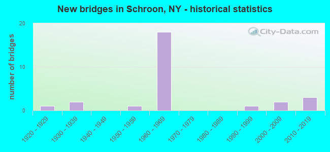
- New bridges - historical statistics
- 11920-1929
- 21930-1939
- 11950-1959
- 181960-1969
- 11990-1999
- 22000-2009
- 32010-2019

- Reconstructed bridges - Historical Statistics
- 11970-1979
- 01980-1989
- 31990-1999
- 12000-2009
- 22010-2019


- Bridge Condition - Deck
- 18.8%Excellent
- 12.5%Very good
- 50.0%Good
- 6.3%Satisfactory
- 6.3%Fair
- 6.3%Poor

- Bridge Condition - Superstructure
- 25.0%Excellent
- 18.8%Very good
- 37.5%Good
- 12.5%Satisfactory
- 6.3%Fair

- Bridge Condition - Substructure
- 25.0%Excellent
- 18.8%Very good
- 31.3%Good
- 18.8%Satisfactory
- 6.3%Critical

- Bridge Condition - Channel
- 43.8%Very good
- 25.0%Good
- 25.0%Satisfactory
- 6.3%Serious

- Bridge Condition - Culverts
- 60.0%Good
- 40.0%Satisfactory
Find on map >> Show street view
Structure Number: 100579, Location: JCT RT 9 & SCHROON LAKE (Lat: 43.835008, Lng: -73.762214), Route carried "on" structure: US 9, Year Built: 1926, Status: Open, Structure Length: 0.98m (3.22ft), Average Daily Traffic: 1,881 (year 2018), Truck Traffic: 8%, Average Future Daily Traffic: 1,962 (year 2040), Features Intersected: ROGERS BROOK
Minimum Vertical Clearance: 30+ m (98+ ft), Kilometerpoint: 8.077, Lanes on structure: 2, Base Highway Network: Yes, Owner: State Highway Agency, Approaching Roadway Width: 9.8m (32.2ft), Skew: 1 degrees, Material/Design: Steel, Design/Construction: Stringer/Multi-beam, Number Of Spans In Main Unit: 1, Length of Maximum Span: 8.2m (26.9ft), Curb or Sidewalk Widths: Left: 1.6m (5.2ft), Right: 1.5m (4.9ft), Curb-To-Curb Width: 9.7m (31.8ft), Out-to-Out Width: 13.8m (45.3ft)
Condition: Deck: Poor, Superstructure: Satisfactory, Substructure: Satisfactory, Channel: Satisfactory, Operating Rating: 52.6 metric tons, Method Used To Determine Operating Rating: Load Factor (LF), Inventory Rating: 25.4 metric tons, Method Used To Determine Inventory Rating: Load Factor (LF), Structural Evaluation: Equal to present minimum criteria, Deck Geometry: Somewhat better than minimum adequacy, Waterway Adequacy: Superior to present desirable criteria, Approach Roadway Alignment: Equal to present desirable criteria, Length Of Structure Improvement: 0.97m (3.18ft), Designated Inspection Frequency: Every 24 months, Inspection Date: September 2020, Bridge Improvement Cost: $455,000, Roadway Improvement Cost: $266,000, Total Project Cost: $721,000 ( Estimate for 2021), Deck Structure Type: Concrete Cast-file-Place, Wearing Surface/Protective System: Wearing Surface: Other
Find on map >> Show street view
Structure Number: 10058, Location: 2 MI N JCT RTES 9 & 74 (Lat: 43.899608, Lng: -73.748428), Route carried "on" structure: State highway 9, Year Built: 1999, Status: Open, Structure Length: 2.71m (8.89ft), Average Daily Traffic: 597 (year 2020), Truck Traffic: 12%, Average Future Daily Traffic: 622 (year 2040), Design Load: HS 25 or greater, Features Intersected: SCHROON RIVER
Minimum Vertical Clearance: 30+ m (98+ ft), Kilometerpoint: 15.382, Lanes on structure: 2, Base Highway Network: Yes, Owner: State Highway Agency, Approaching Roadway Width: 10.2m (33.5ft), Material/Design: Steel, Design/Construction: Stringer/Multi-beam, Number Of Spans In Main Unit: 1, Length of Maximum Span: 25.9m (85.0ft), Curb-To-Curb Width: 10.2m (33.5ft), Out-to-Out Width: 10.8m (35.4ft)
Condition: Deck: Very good, Superstructure: Very good, Substructure: Very good, Channel: Good, Operating Rating: 89.8 metric tons, Method Used To Determine Operating Rating: Load Factor (LF), Inventory Rating: 57.2 metric tons, Method Used To Determine Inventory Rating: Load Factor (LF), Structural Evaluation: Equal to present desirable criteria, Deck Geometry: Equal to present minimum criteria, Waterway Adequacy: Superior to present desirable criteria, Approach Roadway Alignment: Better than present minimum criteria, Length Of Structure Improvement: 2.71m (8.89ft), Designated Inspection Frequency: Every 24 months, Inspection Date: August 2021, Bridge Improvement Cost: $935,000, Roadway Improvement Cost: $548,000, Total Project Cost: $1,483,000 ( Estimate for 2021), Deck Structure Type: Concrete Cast-file-Place, Wearing Surface/Protective System: Wearing Surface: Integral Concrete, Deck Protection: Epoxy Coated Reinforcing
Find on map >> Show street view
Structure Number: 102964, Location: JCT RT 73 & PARADOX LAKE (Lat: 43.875539, Lng: -73.729328), Route carried "on" structure: US 74, Year Built: 1936, Year Reconstructed: 2002, Status: Open, Structure Length: 1.10m (3.61ft), Average Daily Traffic: 1,643 (year 2020), Truck Traffic: 14%, Average Future Daily Traffic: 1,752 (year 2040), Features Intersected: PARADOX LK OUTLET
Minimum Vertical Clearance: 30+ m (98+ ft), Kilometerpoint: 2.253, Lanes on structure: 2, Base Highway Network: Yes, Owner: State Highway Agency, Approaching Roadway Width: 10.4m (34.1ft), Skew: 1 degrees, Material/Design: Concrete continuous, Design/Construction: Culvert, Number Of Spans In Main Unit: 2, Length of Maximum Span: 5.1m (16.7ft)
Condition: Channel: Good, Culverts: Good, Operating Rating: 62.6 metric tons, Method Used To Determine Operating Rating: Load Factor (LF), Inventory Rating: 37.2 metric tons, Method Used To Determine Inventory Rating: Load Factor (LF), Structural Evaluation: Better than present minimum criteria, Waterway Adequacy: Superior to present desirable criteria, Approach Roadway Alignment: Equal to present desirable criteria, Length Of Structure Improvement: 1.09m (3.58ft), Designated Inspection Frequency: Every 24 months, Inspection Date: October 2020, Bridge Improvement Cost: $200,000, Roadway Improvement Cost: $117,000, Total Project Cost: $318,000 ( Estimate for 2021), Wearing Surface/Protective System: Wearing Surface: Bituminous
Find on map >> Show street view
Structure Number: 102965, Location: JCT RT 74 & SCHROON R (Lat: 43.874431, Lng: -73.741161), Route carried "on" structure: State highway 74, Year Built: 1936, Year Reconstructed: 1983, Status: Open, Structure Length: 3.75m (12.30ft), Average Daily Traffic: 1,643 (year 2020), Truck Traffic: 14%, Average Future Daily Traffic: 1,752 (year 2040), Design Load: HS 25 or greater, Features Intersected: SCHROON RIVER
Minimum Vertical Clearance: 30+ m (98+ ft), Kilometerpoint: 1.239, Lanes on structure: 2, Base Highway Network: Yes, Owner: State Highway Agency, Approaching Roadway Width: 7.3m (24.0ft), Material/Design: Steel, Design/Construction: Truss - Thru, Number Of Spans In Main Unit: 1, Length of Maximum Span: 37.2m (122.0ft), Curb-To-Curb Width: 7.3m (24.0ft), Out-to-Out Width: 8.1m (26.6ft)
Condition: Deck: Fair, Superstructure: Fair, Substructure: Satisfactory, Channel: Satisfactory, Operating Rating: 75.3 metric tons, Method Used To Determine Operating Rating: Load Factor (LF), Inventory Rating: 44.5 metric tons, Method Used To Determine Inventory Rating: Load Factor (LF), Structural Evaluation: Somewhat better than minimum adequacy, Deck Geometry: Meets minimum limits, Waterway Adequacy: Meets minimum limits, Approach Roadway Alignment: Equal to present desirable criteria, Length Of Structure Improvement: 3.74m (12.27ft), Designated Inspection Frequency: Every 24 months, Critical Feature Inspection Frequency: Every 24 months, Inspection Date: June 2020, Critical Feature Inspection Date: June 2020, Bridge Improvement Cost: $2,847,000, Roadway Improvement Cost: $1,667,000, Total Project Cost: $4,514,000 ( Estimate for 2021), Deck Structure Type: Concrete Cast-file-Place, Wearing Surface/Protective System: Wearing Surface: Bituminous, Deck Protection: Epoxy Coated Reinforcing
Find on map >> Show street view
Structure Number: 1033661, Location: I87 EXIT 27 (Lat: 43.780286, Lng: -73.799056), Route carried "on" structure: Interstate 87, Year Built: 1965, Status: Open, Structure Length: 3.69m (12.11ft), Average Daily Traffic: 6,098 (year 2014), Truck Traffic: 28%, Design Load: H 20, Features Intersected: RTE 9 CONNECTOR
Minimum Vertical Clearance: 30+ m (98+ ft), Kilometerpoint: 1.223, Lanes on structure: 2, Lanes under structure: 2, Base Highway Network: Yes, Owner: State Highway Agency, Approaching Roadway Width: 11.9m (39.0ft), Material/Design: Steel, Design/Construction: Stringer/Multi-beam, Number Of Spans In Main Unit: 1, Length of Maximum Span: 35.3m (115.8ft), Curb-To-Curb Width: 11.9m (39.0ft), Out-to-Out Width: 12.8m (42.0ft)
Condition: Deck: Good, Superstructure: Good, Substructure: Good, Operating Rating: 82.6 metric tons, Method Used To Determine Operating Rating: Load Factor (LF), Inventory Rating: 49.9 metric tons, Method Used To Determine Inventory Rating: Load Factor (LF), Structural Evaluation: Better than present minimum criteria, Deck Geometry: Equal to present minimum criteria, Underclear: High priority of corrective action, Approach Roadway Alignment: Equal to present desirable criteria, Length Of Structure Improvement: 3.68m (12.07ft), Designated Inspection Frequency: Every 24 months, Inspection Date: March 2021, Bridge Improvement Cost: $1,126,000, Roadway Improvement Cost: $659,000, Total Project Cost: $1,785,000 ( Estimate for 2021), Deck Structure Type: Concrete Cast-file-Place, Wearing Surface/Protective System: Wearing Surface: Monolithic Concrete
Find on map >> Show street view
Structure Number: 1033662, Location: I87 EXIT 27 (Lat: 43.780194, Lng: -73.798522), Route carried "on" structure: Interstate 87, Year Built: 1965, Status: Open, Structure Length: 3.69m (12.11ft), Average Daily Traffic: 4,165 (year 2014), Truck Traffic: 28%, Average Future Daily Traffic: 4,960 (year 2040), Design Load: H 20, Features Intersected: RTE 9 CONNECTOR
Minimum Vertical Clearance: 30+ m (98+ ft), Kilometerpoint: 1.223, Lanes on structure: 2, Lanes under structure: 2, Base Highway Network: Yes, Owner: State Highway Agency, Approaching Roadway Width: 11.6m (38.1ft), Material/Design: Steel, Design/Construction: Stringer/Multi-beam, Number Of Spans In Main Unit: 1, Length of Maximum Span: 35.3m (115.8ft), Curb-To-Curb Width: 11.9m (39.0ft), Out-to-Out Width: 12.8m (42.0ft)
Condition: Deck: Good, Superstructure: Satisfactory, Substructure: Good, Operating Rating: 82.6 metric tons, Method Used To Determine Operating Rating: Load Factor (LF), Inventory Rating: 49.9 metric tons, Method Used To Determine Inventory Rating: Load Factor (LF), Structural Evaluation: Equal to present minimum criteria, Deck Geometry: Equal to present minimum criteria, Underclear: Meets minimum limits, Approach Roadway Alignment: Equal to present desirable criteria, Length Of Structure Improvement: 3.68m (12.07ft), Designated Inspection Frequency: Every 24 months, Inspection Date: March 2021, Bridge Improvement Cost: $1,111,000, Roadway Improvement Cost: $651,000, Total Project Cost: $1,761,000 ( Estimate for 2021), Deck Structure Type: Concrete Cast-file-Place, Wearing Surface/Protective System: Wearing Surface: Monolithic Concrete
Find on map >> Show street view
Structure Number: 103367, Location: JCT I87 & CHARLIE HILL RD (Lat: 43.822847, Lng: -73.778944), Route carried "on" structure: Other road , Year Built: 1965, Status: Open, Structure Length: 3.60m (11.81ft), Average Daily Traffic: 221 (year 2020), Truck Traffic: 6%, Average Future Daily Traffic: 309 (year 2040), Design Load: H 20, Features Intersected: RTE I87, Facility Carried by Structure: CHARLIE HILL ROAD
Minimum Vertical Clearance: 30+ m (98+ ft), Kilometerpoint: 10.105, Lanes on structure: 2, Lanes under structure: 2, Owner: State Highway Agency, Approaching Roadway Width: 7.9m (25.9ft), Material/Design: Steel, Design/Construction: Stringer/Multi-beam, Number Of Spans In Main Unit: 1, Length of Maximum Span: 34.4m (112.9ft), Curb or Sidewalk Widths: Left: 0.8m (2.6ft), Right: 0.8m (2.6ft), Curb-To-Curb Width: 7.3m (24.0ft), Out-to-Out Width: 8.8m (28.9ft)
Condition: Deck: Good, Superstructure: Good, Substructure: Very good, Operating Rating: 38.9 metric tons, Method Used To Determine Operating Rating: Load and Resistance Factor Rating (LRFR) rating reported by rating factor(RF) method using HL-93 loadings, Inventory Rating: 32.4 metric tons, Method Used To Determine Inventory Rating: Load and Resistance Factor Rating (LRFR) rating reported by rating factor(RF) method using HL-93 loadings, Structural Evaluation: Better than present minimum criteria, Deck Geometry: Somewhat better than minimum adequacy, Underclear: Somewhat better than minimum adequacy, Approach Roadway Alignment: Equal to present desirable criteria, Length Of Structure Improvement: 3.59m (11.78ft), Designated Inspection Frequency: Every 24 months, Inspection Date: March 2021, Bridge Improvement Cost: $746,000, Roadway Improvement Cost: $437,000, Total Project Cost: $1,183,000 ( Estimate for 2021), Deck Structure Type: Concrete Cast-file-Place, Wearing Surface/Protective System: Wearing Surface: Monolithic Concrete
Find on map >> Show street view
Structure Number: 1033681, Location: 1.4 MI N EXIT 27 OF I87 (Lat: 43.799300, Lng: -73.792192), Route carried "on" structure: Interstate 87, Year Built: 1965, Year Reconstructed: 2003, Status: Open, Structure Length: 0.67m (2.20ft), Average Daily Traffic: 4,260 (year 2009), Truck Traffic: 28%, Average Future Daily Traffic: 5,964 (year 2029), Features Intersected: THURMAN POND OUTL
Minimum Vertical Clearance: 30+ m (98+ ft), Kilometerpoint: 3.427, Lanes on structure: 2, Base Highway Network: Yes, Owner: State Highway Agency, Approaching Roadway Width: 12.5m (41.0ft), Skew: 3 degrees, Material/Design: Steel, Design/Construction: Culvert, Number Of Spans In Main Unit: 2, Length of Maximum Span: 2.6m (8.5ft)
Condition: Channel: Satisfactory, Culverts: Good, Operating Rating: 74.5 metric tons, Method Used To Determine Operating Rating: Field evaluation and documented engineering judgment, Inventory Rating: 32.7 metric tons, Method Used To Determine Inventory Rating: Field evaluation and documented engineering judgment, Structural Evaluation: Better than present minimum criteria, Waterway Adequacy: Superior to present desirable criteria, Approach Roadway Alignment: Equal to present desirable criteria, Length Of Structure Improvement: 0.67m (2.20ft), Designated Inspection Frequency: Every 24 months, Inspection Date: September 2020, Bridge Improvement Cost: $148,000, Roadway Improvement Cost: $86,000, Total Project Cost: $234,000 ( Estimate for 2021)
Find on map >> Show street view
Structure Number: 1033682, Location: 1.3 MI N EXIT 27 OF I87 (Lat: 43.798881, Lng: -73.791692), Route carried "on" structure: Interstate 87, Year Built: 1965, Year Reconstructed: 2003, Status: Open, Structure Length: 0.64m (2.10ft), Average Daily Traffic: 2,754 (year 2009), Truck Traffic: 28%, Average Future Daily Traffic: 3,280 (year 2040), Features Intersected: THURMAN POND OUTL
Minimum Vertical Clearance: 30+ m (98+ ft), Kilometerpoint: 3.379, Lanes on structure: 2, Base Highway Network: Yes, Owner: State Highway Agency, Approaching Roadway Width: 12.5m (41.0ft), Skew: 2 degrees, Material/Design: Steel, Design/Construction: Culvert, Number Of Spans In Main Unit: 2, Length of Maximum Span: 2.6m (8.5ft)
Condition: Channel: Satisfactory, Culverts: Good, Operating Rating: 74.5 metric tons, Method Used To Determine Operating Rating: Field evaluation and documented engineering judgment, Inventory Rating: 32.7 metric tons, Method Used To Determine Inventory Rating: Field evaluation and documented engineering judgment, Structural Evaluation: Better than present minimum criteria, Waterway Adequacy: Superior to present desirable criteria, Approach Roadway Alignment: Equal to present desirable criteria, Length Of Structure Improvement: 0.64m (2.10ft), Designated Inspection Frequency: Every 24 months, Inspection Date: September 2020, Bridge Improvement Cost: $141,000, Roadway Improvement Cost: $82,000, Total Project Cost: $223,000 ( Estimate for 2021)
Find on map >> Show street view
Structure Number: 1033691, Location: I87 EXIT 28 (Lat: 43.871194, Lng: -73.754383), Route carried "on" structure: Interstate 87, Year Built: 1965, Status: Open, Structure Length: 6.95m (22.80ft), Average Daily Traffic: 4,498 (year 2015), Truck Traffic: 28%, Design Load: HS 20+Mod, Features Intersected: RTE 74, PLATT BROOK
Minimum Vertical Clearance: 30+ m (98+ ft), Kilometerpoint: 12.003, Lanes on structure: 2, Lanes under structure: 2, Base Highway Network: Yes, Owner: State Highway Agency, Approaching Roadway Width: 11.6m (38.1ft), Material/Design: Steel, Design/Construction: Stringer/Multi-beam, Number Of Spans In Main Unit: 2, Length of Maximum Span: 33.8m (110.9ft), Curb-To-Curb Width: 8.7m (28.5ft), Out-to-Out Width: 10.2m (33.5ft)
Condition: Deck: Good, Superstructure: Good, Substructure: Good, Channel: Very good, Operating Rating: 71.7 metric tons, Method Used To Determine Operating Rating: Load Factor (LF), Inventory Rating: 42.6 metric tons, Method Used To Determine Inventory Rating: Load Factor (LF), Structural Evaluation: Better than present minimum criteria, Deck Geometry: High priority of corrective action, Underclear: Somewhat better than minimum adequacy, Waterway Adequacy: Superior to present desirable criteria, Approach Roadway Alignment: Equal to present desirable criteria, Length Of Structure Improvement: 6.94m (22.77ft), Designated Inspection Frequency: Every 24 months, Inspection Date: July 2021, Bridge Improvement Cost: $1,540,000, Roadway Improvement Cost: $902,000, Total Project Cost: $2,442,000 ( Estimate for 2021), Deck Structure Type: Concrete Cast-file-Place, Wearing Surface/Protective System: Wearing Surface: Bituminous, Membrane: Other
Find on map >> Show street view
Structure Number: 1033692, Location: I87 EXIT 28 (Lat: 43.871047, Lng: -73.753839), Route carried "on" structure: Interstate 87, Year Built: 1965, Status: Open, Structure Length: 5.82m (19.09ft), Average Daily Traffic: 3,104 (year 2015), Truck Traffic: 31%, Average Future Daily Traffic: 3,697 (year 2040), Design Load: HS 20+Mod, Features Intersected: RTE 74, PLATT BROOK
Minimum Vertical Clearance: 30+ m (98+ ft), Kilometerpoint: 12.003, Lanes on structure: 2, Lanes under structure: 2, Base Highway Network: Yes, Owner: State Highway Agency, Approaching Roadway Width: 11.6m (38.1ft), Material/Design: Steel, Design/Construction: Stringer/Multi-beam, Number Of Spans In Main Unit: 2, Length of Maximum Span: 28.3m (92.8ft), Curb-To-Curb Width: 11.9m (39.0ft), Out-to-Out Width: 12.9m (42.3ft)
Condition: Deck: Good, Superstructure: Good, Substructure: Good, Channel: Very good, Operating Rating: 74.4 metric tons, Method Used To Determine Operating Rating: Load Factor (LF), Inventory Rating: 44.5 metric tons, Method Used To Determine Inventory Rating: Load Factor (LF), Structural Evaluation: Better than present minimum criteria, Deck Geometry: Equal to present minimum criteria, Underclear: Meets minimum limits, Waterway Adequacy: Superior to present desirable criteria, Approach Roadway Alignment: Equal to present desirable criteria, Length Of Structure Improvement: 5.82m (19.09ft), Designated Inspection Frequency: Every 24 months, Inspection Date: July 2021, Bridge Improvement Cost: $1,639,000, Roadway Improvement Cost: $960,000, Total Project Cost: $2,598,000 ( Estimate for 2021), Deck Structure Type: Concrete Cast-file-Place, Wearing Surface/Protective System: Wearing Surface: Bituminous, Membrane: Other
Find on map >> Show street view
Structure Number: 105416, Location: JCT I87 & CHARLIE HILL RD (Lat: 43.822722, Lng: -73.777892), Route carried "on" structure: Other road , Year Built: 1965, Status: Open, Structure Length: 3.60m (11.81ft), Average Daily Traffic: 221 (year 2020), Truck Traffic: 6%, Average Future Daily Traffic: 309 (year 2040), Design Load: H 20, Features Intersected: RTE I87, Facility Carried by Structure: CHARLIE HILL ROAD
Minimum Vertical Clearance: 30+ m (98+ ft), Kilometerpoint: 10.201, Lanes on structure: 2, Lanes under structure: 2, Owner: State Highway Agency, Approaching Roadway Width: 7.9m (25.9ft), Material/Design: Steel, Design/Construction: Stringer/Multi-beam, Number Of Spans In Main Unit: 1, Length of Maximum Span: 34.4m (112.9ft), Curb or Sidewalk Widths: Left: 0.8m (2.6ft), Right: 0.8m (2.6ft), Curb-To-Curb Width: 7.3m (24.0ft), Out-to-Out Width: 8.8m (28.9ft)
Condition: Deck: Good, Superstructure: Good, Substructure: Very good, Operating Rating: 45.4 metric tons, Method Used To Determine Operating Rating: Load and Resistance Factor Rating (LRFR) rating reported by rating factor(RF) method using HL-93 loadings, Inventory Rating: 32.4 metric tons, Method Used To Determine Inventory Rating: Load and Resistance Factor Rating (LRFR) rating reported by rating factor(RF) method using HL-93 loadings, Structural Evaluation: Better than present minimum criteria, Deck Geometry: Somewhat better than minimum adequacy, Underclear: Meets minimum limits, Approach Roadway Alignment: Equal to present desirable criteria, Length Of Structure Improvement: 3.59m (11.78ft), Designated Inspection Frequency: Every 24 months, Inspection Date: March 2021, Bridge Improvement Cost: $803,000, Roadway Improvement Cost: $470,000, Total Project Cost: $1,273,000 ( Estimate for 2021), Deck Structure Type: Concrete Cast-file-Place, Wearing Surface/Protective System: Wearing Surface: Monolithic Concrete
Find on map >> Show street view
Structure Number: 105417, Location: JCT I87 & CR 24 (Lat: 43.834311, Lng: -73.771642), Route carried "on" structure: County highway , Year Built: 1965, Year Reconstructed: 2010, Status: Open, Structure Length: 7.86m (25.79ft), Average Daily Traffic: 596 (year 2020), Truck Traffic: 6%, Average Future Daily Traffic: 834 (year 2040), Design Load: H 20, Features Intersected: 87I 87I12111048NB, RTE I, Facility Carried by Structure: COUNTY ROAD 24
Minimum Vertical Clearance: 30+ m (98+ ft), Kilometerpoint: 20.225, Lanes on structure: 2, Lanes under structure: 4, Owner: State Highway Agency, Approaching Roadway Width: 7.3m (24.0ft), Skew: 2 degrees, Material/Design: Steel, Design/Construction: Stringer/Multi-beam, Number Of Spans In Main Unit: 4, Length of Maximum Span: 24.3m (79.7ft), Curb or Sidewalk Widths: Left: 0.5m (1.6ft), Right: 0.5m (1.6ft), Curb-To-Curb Width: 7.3m (24.0ft), Out-to-Out Width: 8.8m (28.9ft)
Condition: Deck: Good, Superstructure: Very good, Substructure: Satisfactory, Operating Rating: 71.7 metric tons, Method Used To Determine Operating Rating: Load Factor (LF), Inventory Rating: 42.6 metric tons, Method Used To Determine Inventory Rating: Load Factor (LF), Structural Evaluation: Equal to present minimum criteria, Deck Geometry: Meets minimum limits, Underclear: High priority of corrective action, Approach Roadway Alignment: Equal to present desirable criteria, Length Of Structure Improvement: 7.86m (25.79ft), Designated Inspection Frequency: Every 24 months, Inspection Date: July 2021, Bridge Improvement Cost: $1,432,000, Roadway Improvement Cost: $839,000, Total Project Cost: $2,271,000 ( Estimate for 2021), Deck Structure Type: Concrete Cast-file-Place, Wearing Surface/Protective System: Wearing Surface: Monolithic Concrete
Find on map >> Show street view
Structure Number: 1074511, Location: .1MI N JCT I87+HOFFMAN RD (Lat: 43.836136, Lng: -73.771689), Route carried "on" structure: Interstate 87, Year Built: 1965, Status: Open, Structure Length: 0.91m (2.99ft), Average Daily Traffic: 4,260 (year 2009), Truck Traffic: 28%, Average Future Daily Traffic: 4,201 (year 2035), Design Load: HS 20+Mod, Features Intersected: ROGERS BROOK
Minimum Vertical Clearance: 30+ m (98+ ft), Kilometerpoint: 7.868, Lanes on structure: 2, Base Highway Network: Yes, Owner: State Highway Agency, Approaching Roadway Width: 12.5m (41.0ft), Material/Design: Steel, Design/Construction: Culvert, Number Of Spans In Main Unit: 2, Length of Maximum Span: 3.9m (12.8ft)
Condition: Channel: Very good, Culverts: Satisfactory, Operating Rating: 74.2 metric tons, Method Used To Determine Operating Rating: Field evaluation and documented engineering judgment, Inventory Rating: 19.6 metric tons, Method Used To Determine Inventory Rating: Field evaluation and documented engineering judgment, Structural Evaluation: Meets minimum limits, Waterway Adequacy: Superior to present desirable criteria, Approach Roadway Alignment: Equal to present desirable criteria, Length Of Structure Improvement: 0.91m (2.99ft), Designated Inspection Frequency: Every 24 months, Inspection Date: September 2020, Bridge Improvement Cost: $202,000, Roadway Improvement Cost: $118,000, Total Project Cost: $319,000 ( Estimate for 2021)
Find on map >> Show street view
Structure Number: 1074512, Location: .1MI N JCT I87&HOFFMAN RD (Lat: 43.836100, Lng: -73.771247), Route carried "on" structure: Interstate 87, Year Built: 1965, Status: Open, Structure Length: 0.91m (2.99ft), Average Daily Traffic: 2,754 (year 2009), Truck Traffic: 28%, Average Future Daily Traffic: 3,280 (year 2040), Design Load: HS 20+Mod, Features Intersected: ROGERS BROOK
Minimum Vertical Clearance: 30+ m (98+ ft), Kilometerpoint: 7.868, Lanes on structure: 2, Base Highway Network: Yes, Owner: State Highway Agency, Approaching Roadway Width: 12.5m (41.0ft), Material/Design: Steel, Design/Construction: Culvert, Number Of Spans In Main Unit: 2, Length of Maximum Span: 3.9m (12.8ft)
Condition: Channel: Very good, Culverts: Satisfactory, Operating Rating: 74.2 metric tons, Method Used To Determine Operating Rating: Field evaluation and documented engineering judgment, Inventory Rating: 19.6 metric tons, Method Used To Determine Inventory Rating: Field evaluation and documented engineering judgment, Structural Evaluation: Meets minimum limits, Waterway Adequacy: Superior to present desirable criteria, Approach Roadway Alignment: Equal to present desirable criteria, Length Of Structure Improvement: 0.91m (2.99ft), Designated Inspection Frequency: Every 24 months, Inspection Date: September 2020, Bridge Improvement Cost: $202,000, Roadway Improvement Cost: $118,000, Total Project Cost: $319,000 ( Estimate for 2021)
Find on map >> Show street view
Structure Number: 330191, Location: .7 MILE S JCT I87 & SH 74 (Lat: 43.863447, Lng: -73.752183), Route carried "on" structure: Other road , Year Built: 2004, Status: Open, Structure Length: 2.87m (9.42ft), Average Daily Traffic: 578 (year 2016), Truck Traffic: 5%, Average Future Daily Traffic: 809 (year 2036), Design Load: HS 25 or greater, Features Intersected: SCHROON RIVER, Facility Carried by Structure: ALDER MEADOW ROAD
Minimum Vertical Clearance: 30+ m (98+ ft), Kilometerpoint: 0.209, Lanes on structure: 2, Owner: County Highway Agency, Approaching Roadway Width: 7.9m (25.9ft), Skew: 2 degrees, Material/Design: Steel, Design/Construction: Truss - Thru, Number Of Spans In Main Unit: 1, Length of Maximum Span: 27.4m (89.9ft), Curb-To-Curb Width: 7.9m (25.9ft), Out-to-Out Width: 8.1m (26.6ft)
Condition: Deck: Good, Superstructure: Good, Substructure: Good, Channel: Very good, Operating Rating: 78.9 metric tons, Method Used To Determine Operating Rating: Load Factor (LF), Inventory Rating: 47.2 metric tons, Method Used To Determine Inventory Rating: Load Factor (LF), Structural Evaluation: Better than present minimum criteria, Deck Geometry: Somewhat better than minimum adequacy, Waterway Adequacy: Superior to present desirable criteria, Approach Roadway Alignment: Meets minimum limits, Length Of Structure Improvement: 2.86m (9.38ft), Designated Inspection Frequency: Every 24 months, Critical Feature Inspection Frequency: Every 12 months, Inspection Date: July 2021, Critical Feature Inspection Date: July 2021, Bridge Improvement Cost: $2,306,000, Roadway Improvement Cost: $1,350,000, Total Project Cost: $3,656,000 ( Estimate for 2021), Deck Structure Type: Concrete Cast-file-Place, Wearing Surface/Protective System: Wearing Surface: Integral Concrete, Deck Protection: Epoxy Coated Reinforcing
Find on map >> Show street view
Structure Number: 330192, Location: 1.5 MI N PARADOX (Lat: 43.909367, Lng: -73.643819), Route carried "on" structure: Other road , Year Built: 2001, Year Reconstructed: 2015, Status: Open, Structure Length: 0.88m (2.89ft), Average Daily Traffic: 211 (year 2018), Truck Traffic: 8%, Average Future Daily Traffic: 295 (year 2038), Design Load: HS 20, Features Intersected: PARADOX CREEK, Facility Carried by Structure: LETSONVILLE ROAD
Minimum Vertical Clearance: 30+ m (98+ ft), Kilometerpoint: 2.381, Lanes on structure: 1, Owner: County Highway Agency, Approaching Roadway Width: 4.6m (15.1ft), Material/Design: Prestressed concrete, Design/Construction: Box Beam or Girders - Multiple, Number Of Spans In Main Unit: 1, Length of Maximum Span: 8.5m (27.9ft), Curb-To-Curb Width: 4.4m (14.4ft), Out-to-Out Width: 4.9m (16.1ft)
Condition: Deck: Excellent, Superstructure: Excellent, Substructure: Excellent, Channel: Very good, Operating Rating: 62.6 metric tons, Method Used To Determine Operating Rating: Load Factor (LF), Inventory Rating: 44.5 metric tons, Method Used To Determine Inventory Rating: Load Factor (LF), Structural Evaluation: Superior to present desirable criteria, Deck Geometry: High priority of replacement, Waterway Adequacy: Superior to present desirable criteria, Approach Roadway Alignment: Equal to present minimum criteria, Length Of Structure Improvement: 0.88m (2.89ft), Designated Inspection Frequency: Every 24 months, Inspection Date: June 2020, Bridge Improvement Cost: $185,000, Roadway Improvement Cost: $108,000, Total Project Cost: $293,000 ( Estimate for 2021), Wearing Surface/Protective System: Wearing Surface: Bituminous
Find on map >> Show street view
Structure Number: 330247, Location: 2 MI.N.OF PARADOX (Lat: 43.917097, Lng: -73.638383), Route carried "on" structure: County highway , Year Built: 2018, Status: Open, Structure Length: 2.29m (7.51ft), Average Daily Traffic: 211 (year 2018), Truck Traffic: 8%, Average Future Daily Traffic: 295 (year 2038), Design Load: HS 20, Features Intersected: PARADOX CREEK, Facility Carried by Structure: OLD FURNACE ROAD
Minimum Vertical Clearance: 30+ m (98+ ft), Kilometerpoint: 3.379, Lanes on structure: 1, Owner: County Highway Agency, Approaching Roadway Width: 7.6m (24.9ft), Material/Design: Steel, Number Of Spans In Main Unit: 1, Length of Maximum Span: 22.6m (74.1ft), Curb-To-Curb Width: 4.2m (13.8ft), Out-to-Out Width: 4.6m (15.1ft)
Condition: Deck: Satisfactory, Superstructure: Very good, Substructure: Excellent, Channel: Good, Operating Rating: 88.6 metric tons, Method Used To Determine Operating Rating: Field evaluation and documented engineering judgment, Inventory Rating: 32.7 metric tons, Method Used To Determine Inventory Rating: Field evaluation and documented engineering judgment, Structural Evaluation: Equal to present desirable criteria, Deck Geometry: High priority of replacement, Waterway Adequacy: Meets minimum limits, Approach Roadway Alignment: Equal to present desirable criteria, Length Of Structure Improvement: 2.28m (7.48ft), Designated Inspection Frequency: Every 24 months, Critical Feature Inspection Frequency: Every 24 months, Inspection Date: April 2020, Critical Feature Inspection Date: April 2020, Bridge Improvement Cost: $199,000, Roadway Improvement Cost: $117,000, Total Project Cost: $316,000 ( Estimate for 2021), Deck Structure Type: Steel plate, Wearing Surface/Protective System: Wearing Surface: Other
Find on map >> Show street view
Structure Number: 330248, Location: AT PARADOX (Lat: 43.893589, Lng: -73.646456), Route carried "on" structure: Other road , Year Built: 2018, Status: Open, Structure Length: 2.23m (7.32ft), Average Daily Traffic: 126 (year 2018), Truck Traffic: 3%, Average Future Daily Traffic: 176 (year 2038), Design Load: HS 20, Features Intersected: PARADOX CREEK, Facility Carried by Structure: FRATERNAL LAND RD
Minimum Vertical Clearance: 30+ m (98+ ft), Kilometerpoint: 2.542, Lanes on structure: 2, Owner: County Highway Agency, Approaching Roadway Width: 8.3m (27.2ft), Material/Design: Prestressed concrete, Design/Construction: Tee Beam, Number Of Spans In Main Unit: 1, Length of Maximum Span: 21.9m (71.9ft), Curb-To-Curb Width: 8.3m (27.2ft), Out-to-Out Width: 9.2m (30.2ft)
Condition: Deck: Excellent, Superstructure: Excellent, Substructure: Excellent, Channel: Good, Operating Rating: 88.2 metric tons, Method Used To Determine Operating Rating: Field evaluation and documented engineering judgment, Inventory Rating: 32.7 metric tons, Method Used To Determine Inventory Rating: Field evaluation and documented engineering judgment, Structural Evaluation: Superior to present desirable criteria, Deck Geometry: Somewhat better than minimum adequacy, Waterway Adequacy: Superior to present desirable criteria, Approach Roadway Alignment: Equal to present minimum criteria, Length Of Structure Improvement: 2.22m (7.28ft), Designated Inspection Frequency: Every 24 months, Inspection Date: April 2021, Bridge Improvement Cost: $735,000, Roadway Improvement Cost: $430,000, Total Project Cost: $1,165,000 ( Estimate for 2021), Deck Structure Type: Concrete Cast-file-Place, Wearing Surface/Protective System: Wearing Surface: Integral Concrete
Find on map >> Show street view
Structure Number: 33027, Location: 6 MI W OF SCHROON LAKE (Lat: 43.839883, Lng: -73.853667), Route carried "on" structure: County highway , Year Built: 2014, Status: Open, Structure Length: 1.58m (5.18ft), Average Daily Traffic: 596 (year 2020), Truck Traffic: 6%, Average Future Daily Traffic: 834 (year 2040), Design Load: HL 93, Features Intersected: TROUT BROOK, Facility Carried by Structure: CR 24, HOFFMAN ROA
Minimum Vertical Clearance: 30+ m (98+ ft), Kilometerpoint: 12.969, Lanes on structure: 2, Owner: County Highway Agency, Approaching Roadway Width: 8.2m (26.9ft), Skew: 1 degrees, Material/Design: Concrete, Design/Construction: Channel Beam, Number Of Spans In Main Unit: 1, Length of Maximum Span: 15.2m (49.9ft), Curb-To-Curb Width: 8.2m (26.9ft), Out-to-Out Width: 9.2m (30.2ft)
Condition: Deck: Very good, Superstructure: Excellent, Substructure: Excellent, Channel: Very good, Operating Rating: 85.3 metric tons, Method Used To Determine Operating Rating: Load Factor (LF), Inventory Rating: 50.8 metric tons, Method Used To Determine Inventory Rating: Load Factor (LF), Structural Evaluation: Superior to present desirable criteria, Deck Geometry: Somewhat better than minimum adequacy, Waterway Adequacy: Superior to present desirable criteria, Approach Roadway Alignment: Meets minimum limits, Length Of Structure Improvement: 1.58m (5.18ft), Designated Inspection Frequency: Every 24 months, Inspection Date: September 2020, Bridge Improvement Cost: $1,249,000, Roadway Improvement Cost: $732,000, Total Project Cost: $1,981,000 ( Estimate for 2021), Wearing Surface/Protective System: Wearing Surface: Integral Concrete
Find on map >> Show street view
Structure Number: 330271, Location: 6MI W.SCHROON LAKE (Lat: 43.823225, Lng: -73.866153), Route carried "on" structure: County highway , Year Built: 1959, Year Reconstructed: 2013, Status: Closed, Structure Length: 0.85m (2.79ft), Average Daily Traffic: 47 (year 2020), Truck Traffic: 7%, Average Future Daily Traffic: 66 (year 2040), Design Load: HL 93, Features Intersected: TROUT BROOK, Facility Carried by Structure: CR 34
Minimum Vertical Clearance: 30+ m (98+ ft), Kilometerpoint: 8.367, Lanes on structure: 2, Owner: County Highway Agency, Approaching Roadway Width: 6.1m (20.0ft), Material/Design: Prestressed concrete, Design/Construction: Box Beam or Girders - Multiple, Number Of Spans In Main Unit: 1, Length of Maximum Span: 7.9m (25.9ft), Curb-To-Curb Width: 6.8m (22.3ft), Out-to-Out Width: 7.8m (25.6ft)
Condition: Deck: Excellent, Superstructure: Excellent, Substructure: Critical, Channel: Serious, Deck Geometry: Somewhat better than minimum adequacy, Waterway Adequacy: Somewhat better than minimum adequacy, Approach Roadway Alignment: High priority of corrective action, Bridge Posting: Required (Relationship of Operating Rating to Maximum Legal Load: > 39.9% below), Length Of Structure Improvement: 0.85m (2.79ft), Designated Inspection Frequency: Every 12 months, Inspection Date: May 2021, Bridge Improvement Cost: $393,000, Roadway Improvement Cost: $230,000, Total Project Cost: $623,000 ( Estimate for 2021), Deck Structure Type: Concrete Cast-file-Place, Wearing Surface/Protective System: Wearing Surface: Integral Concrete, Deck Protection: Epoxy Coated Reinforcing
Find on map >> Show street view
Structure Number: 1033661, Location: I87 EXIT 27 (Lat: 43.780286, Lng: -73.799056), Route carried "under" structure: Other road , Year Built: 1965, Structure Length: 0. m, Average Daily Traffic: 200 (year 2021), Features Intersected: RTE 9 CONNECTOR, Facility Carried by Structure: RTE I87
Minimum Vertical Clearance: 4.80m (15.75ft), Kilometerpoint: 0.000, Lanes on structure: 2, Lanes under structure: 2, Material/Design: Steel, Design/Construction: Stringer/Multi-beam, Length of Maximum Span: 35.3m (115.8ft)
Find on map >> Show street view
Structure Number: 1033662, Location: I87 EXIT 27 (Lat: 43.780194, Lng: -73.798522), Route carried "under" structure: Other road , Year Built: 1965, Structure Length: 0. m, Average Daily Traffic: 100 (year 2021), Features Intersected: RTE 9 CONNECTOR, Facility Carried by Structure: RTE I87
Minimum Vertical Clearance: 4.77m (15.65ft), Kilometerpoint: 0.000, Lanes on structure: 2, Lanes under structure: 2, Material/Design: Steel, Design/Construction: Stringer/Multi-beam, Length of Maximum Span: 35.3m (115.8ft)
Find on map >> Show street view
Structure Number: 103367, Location: JCT I87 & CHARLIE HILL RD (Lat: 43.822847, Lng: -73.778944), Route carried "under" structure: Interstate 87, Year Built: 1965, Structure Length: 0. m, Average Daily Traffic: 8,884 (year 1999), Features Intersected: RTE I87, Facility Carried by Structure: CHARLIE HILL ROAD
Minimum Vertical Clearance: 5.28m (17.32ft), Kilometerpoint: 6.677, Lanes on structure: 2, Lanes under structure: 2, Material/Design: Steel, Design/Construction: Stringer/Multi-beam, Length of Maximum Span: 34.4m (112.9ft)
Find on map >> Show street view
Structure Number: 1033691, Location: I87 EXIT 28 (Lat: 43.871194, Lng: -73.754383), Route carried "under" structure: State highway 74, Year Built: 1965, Structure Length: 0. m, Average Daily Traffic: 680 (year 1977), Features Intersected: RTE 74, PLATT BROOK, Facility Carried by Structure: RTE I87
Minimum Vertical Clearance: 6.83m (22.41ft), Kilometerpoint: 33.467, Lanes on structure: 2, Lanes under structure: 2, Material/Design: Steel, Design/Construction: Stringer/Multi-beam, Length of Maximum Span: 33.8m (110.9ft)
Find on map >> Show street view
Structure Number: 1033692, Location: I87 EXIT 28 (Lat: 43.871047, Lng: -73.753839), Route carried "under" structure: State highway 74, Year Built: 1965, Structure Length: 0. m, Average Daily Traffic: 680 (year 1977), Features Intersected: RTE 74, PLATT BROOK, Facility Carried by Structure: RTE I87
Minimum Vertical Clearance: 4.54m (14.90ft), Kilometerpoint: 33.306, Lanes on structure: 2, Lanes under structure: 2, Material/Design: Steel, Design/Construction: Stringer/Multi-beam, Length of Maximum Span: 28.3m (92.8ft)
Find on map >> Show street view
Structure Number: 105416, Location: JCT I87 & CHARLIE HILL RD (Lat: 43.822722, Lng: -73.777892), Route carried "under" structure: Interstate 87, Year Built: 1965, Structure Length: 0. m, Average Daily Traffic: 8,884 (year 1999), Features Intersected: RTE I87, Facility Carried by Structure: CHARLIE HILL ROAD
Minimum Vertical Clearance: 5.31m (17.42ft), Kilometerpoint: 6.629, Lanes on structure: 2, Lanes under structure: 2, Material/Design: Steel, Design/Construction: Stringer/Multi-beam, Length of Maximum Span: 34.4m (112.9ft)
Find on map >> Show street view
Structure Number: 105417, Location: JCT I87 & CR 24 (Lat: 43.834311, Lng: -73.771642), Route carried "under" structure: Interstate 87, Year Built: 1965, Structure Length: 0. m, Average Daily Traffic: 8,884 (year 1999), Features Intersected: 87I 87I12111048NB, RTE I, Facility Carried by Structure: COUNTY ROAD 24
Minimum Vertical Clearance: 5.05m (16.57ft), Kilometerpoint: 8.174, Lanes on structure: 2, Lanes under structure: 2, Material/Design: Steel, Design/Construction: Stringer/Multi-beam, Length of Maximum Span: 24.3m (79.7ft)