Bridge Statistics for Saugerties, New York (NY)
Condition, Traffic, Stress, Structural Evaluation, Project Costs
- National Bridge Inventory (NBI) Statistics
- 12Number of bridges
- 118ft / 36.2mTotal length
- $32,067,000Total costs
- 113,684Total average daily traffic
- 2,110Total average daily truck traffic
- National Bridge Inventory (NBI) Registered Bridges for Saugerties
- No street view available for this location
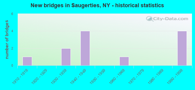
- New bridges - historical statistics
- 11910-1919
- 21930-1939
- 41940-1949
- 11960-1969
- 41990-1999


- Bridge Condition - Deck
- 62.5%Satisfactory
- 12.5%Fair
- 25.0%Poor

- Bridge Condition - Superstructure
- 12.5%Excellent
- 37.5%Satisfactory
- 12.5%Fair
- 37.5%Poor

- Bridge Condition - Substructure
- 12.5%Very good
- 25.0%Good
- 37.5%Satisfactory
- 25.0%Fair

- Bridge Condition - Channel
- 50.0%Good
- 16.7%Satisfactory
- 16.7%Fair
- 16.7%Poor
Find on map >> Show street view
Structure Number: 100737, Location: 7.3 MI N JCT RTS 9W+209 (Lat: 42.071481, Lng: -73.950556), Route carried "on" structure: US 9W, Year Built: 1932, Year Reconstructed: 1991, Status: Open, Structure Length: 8.14m (26.71ft), Average Daily Traffic: 10,532 (year 2018), Truck Traffic: 3%, Average Future Daily Traffic: 12,794 (year 2040), Design Load: HS 20, Features Intersected: ESOPUS CREEK
Minimum Vertical Clearance: 5.07m (16.63ft), Kilometerpoint: 57.087, Lanes on structure: 2, Base Highway Network: Yes, Owner: State Highway Agency, Approaching Roadway Width: 7.3m (24.0ft), Material/Design: Steel, Design/Construction: Truss - Thru, Number Of Spans In Main Unit: 1, Length of Maximum Span: 80.1m (262.8ft), Curb or Sidewalk Widths: Left: 1.5m (4.9ft), Right: 1.5m (4.9ft), Curb-To-Curb Width: 7.3m (24.0ft), Out-to-Out Width: 8.1m (26.6ft)
Condition: Deck: Satisfactory, Superstructure: Poor, Substructure: Satisfactory, Channel: Good, Operating Rating: 43.5 metric tons, Method Used To Determine Operating Rating: Load Factor (LF), Inventory Rating: 25.4 metric tons, Method Used To Determine Inventory Rating: Load Factor (LF), Structural Evaluation: Meets minimum limits, Deck Geometry: High priority of replacement, Waterway Adequacy: Equal to present minimum criteria, Approach Roadway Alignment: Meets minimum limits, Length Of Structure Improvement: 8.13m (26.67ft), Designated Inspection Frequency: Every 24 months, Critical Feature Inspection Frequency: Every 12 months, Inspection Date: October 2021, Critical Feature Inspection Date: October 2021, Bridge Improvement Cost: $4,830,000, Roadway Improvement Cost: $2,829,000, Total Project Cost: $7,659,000 ( Estimate for 2021), Deck Structure Type: Concrete Cast-file-Place, Wearing Surface/Protective System: Wearing Surface: Integral Concrete, Deck Protection: Epoxy Coated Reinforcing
Find on map >> Show street view
Structure Number: 100738, Location: 0.7 MI N JCT RTS 9W & 32 (Lat: 42.084336, Lng: -73.943247), Route carried "on" structure: US 9W, Year Built: 1917, Year Reconstructed: 1992, Status: Open, Structure Length: 1.28m (4.20ft), Average Daily Traffic: 2,670 (year 2016), Truck Traffic: 7%, Average Future Daily Traffic: 3,243 (year 2040), Design Load: HS 20, Features Intersected: SAWYERKILL CREEK
Minimum Vertical Clearance: 30+ m (98+ ft), Kilometerpoint: 59.131, Lanes on structure: 2, Base Highway Network: Yes, Owner: State Highway Agency, Approaching Roadway Width: 6.7m (22.0ft), Material/Design: Prestressed concrete, Design/Construction: Box Beam or Girders - Multiple, Number Of Spans In Main Unit: 1, Length of Maximum Span: 11.8m (38.7ft), Curb-To-Curb Width: 9.7m (31.8ft), Out-to-Out Width: 10.7m (35.1ft)
Condition: Deck: Satisfactory, Superstructure: Satisfactory, Substructure: Fair, Channel: Good, Operating Rating: 74.8 metric tons, Method Used To Determine Operating Rating: Load and Resistance Factor Rating (LRFR) rating reported by rating factor(RF) method using HL-93 loadings, Inventory Rating: 57.7 metric tons, Method Used To Determine Inventory Rating: Load and Resistance Factor Rating (LRFR) rating reported by rating factor(RF) method using HL-93 loadings, Structural Evaluation: Somewhat better than minimum adequacy, Deck Geometry: Meets minimum limits, Waterway Adequacy: Superior to present desirable criteria, Approach Roadway Alignment: Equal to present desirable criteria, Length Of Structure Improvement: 1.28m (4.20ft), Designated Inspection Frequency: Every 24 months, Inspection Date: July 2020, Bridge Improvement Cost: $883,000, Roadway Improvement Cost: $517,000, Total Project Cost: $1,400,000 ( Estimate for 2021), Wearing Surface/Protective System: Wearing Surface: Integral Concrete
Find on map >> Show street view
Structure Number: 102235, Location: 0.2 MI JCT RTS 32 & 212 2 (Lat: 42.083639, Lng: -73.973289), Route carried "on" structure: State highway 32, Year Built: 1999, Status: Open, Structure Length: 5.91m (19.39ft), Average Daily Traffic: 13,564 (year 2019), Truck Traffic: 4%, Average Future Daily Traffic: 16,477 (year 2040), Design Load: HS 25 or greater, Features Intersected: 87IX, RTE I87
Minimum Vertical Clearance: 30+ m (98+ ft), Kilometerpoint: 64.280, Lanes on structure: 3, Lanes under structure: 6, Base Highway Network: Yes, Owner: State Highway Agency, Maintenance Responsibility: State Toll Authority, Approaching Roadway Width: 17.1m (56.1ft), Skew: 1 degrees, Material/Design: Steel continuous, Design/Construction: Stringer/Multi-beam, Number Of Spans In Main Unit: 2, Length of Maximum Span: 29.0m (95.1ft), Curb-To-Curb Width: 17.1m (56.1ft), Out-to-Out Width: 18.0m (59.1ft)
Condition: Deck: Satisfactory, Superstructure: Excellent, Substructure: Very good, Operating Rating: 75.3 metric tons, Method Used To Determine Operating Rating: Load Factor (LF), Inventory Rating: 43.5 metric tons, Method Used To Determine Inventory Rating: Load Factor (LF), Structural Evaluation: Equal to present desirable criteria, Deck Geometry: Superior to present desirable criteria, Underclear: High priority of corrective action, Approach Roadway Alignment: Equal to present desirable criteria, Length Of Structure Improvement: 5.91m (19.39ft), Designated Inspection Frequency: Every 24 months, Inspection Date: October 2020, Bridge Improvement Cost: $5,539,000, Roadway Improvement Cost: $3,243,000, Total Project Cost: $8,782,000 ( Estimate for 2021), Deck Structure Type: Concrete Cast-file-Place, Wearing Surface/Protective System: Wearing Surface: Integral Concrete, Deck Protection: Galvanized Reinforcing
Find on map >> Show street view
Structure Number: 102236, Location: 2.2MI N JCT RTS 32 & 212 (Lat: 42.113369, Lng: -73.972358), Route carried "on" structure: State highway 32, Year Built: 1994, Status: Open, Structure Length: 0.70m (2.30ft), Average Daily Traffic: 7,301 (year 2016), Truck Traffic: 6%, Average Future Daily Traffic: 8,108 (year 2040), Design Load: HS 25 or greater, Features Intersected: BEAVER KILL
Minimum Vertical Clearance: 30+ m (98+ ft), Kilometerpoint: 68.045, Lanes on structure: 2, Base Highway Network: Yes, Owner: State Highway Agency, Approaching Roadway Width: 13.4m (44.0ft), Skew: 3 degrees, Material/Design: Concrete, Design/Construction: Culvert, Number Of Spans In Main Unit: 1, Length of Maximum Span: 6.4m (21.0ft)
Condition: Channel: Satisfactory, Culverts: Satisfactory, Operating Rating: 92.5 metric tons, Method Used To Determine Operating Rating: Load Factor (LF), Inventory Rating: 55.3 metric tons, Method Used To Determine Inventory Rating: Load Factor (LF), Structural Evaluation: Equal to present minimum criteria, Waterway Adequacy: Somewhat better than minimum adequacy, Approach Roadway Alignment: Equal to present desirable criteria, Length Of Structure Improvement: 0.70m (2.30ft), Designated Inspection Frequency: Every 24 months, Inspection Date: December 2021, Bridge Improvement Cost: $265,000, Roadway Improvement Cost: $155,000, Total Project Cost: $420,000 ( Estimate for 2021)
Find on map >> Show street view
Structure Number: 104113, Location: 5.6 MI E JCT RTS 212+375 (Lat: 42.076247, Lng: -74.023019), Route carried "on" structure: State highway 212, Year Built: 1930, Year Reconstructed: 1988, Status: Open, Structure Length: 2.26m (7.41ft), Average Daily Traffic: 3,714 (year 2016), Truck Traffic: 5%, Average Future Daily Traffic: 3,874 (year 2040), Design Load: H 15, Features Intersected: PLATTEKILL CREEK
Minimum Vertical Clearance: 30+ m (98+ ft), Kilometerpoint: 28.302, Lanes on structure: 2, Base Highway Network: Yes, Owner: State Highway Agency, Approaching Roadway Width: 10.4m (34.1ft), Material/Design: Steel, Design/Construction: Stringer/Multi-beam, Number Of Spans In Main Unit: 1, Length of Maximum Span: 21.3m (69.9ft), Curb-To-Curb Width: 10.4m (34.1ft), Out-to-Out Width: 11.0m (36.1ft)
Condition: Deck: Satisfactory, Superstructure: Satisfactory, Substructure: Satisfactory, Channel: Fair, Operating Rating: 98.9 metric tons, Method Used To Determine Operating Rating: Load Factor (LF), Inventory Rating: 59.0 metric tons, Method Used To Determine Inventory Rating: Load Factor (LF), Structural Evaluation: Equal to present minimum criteria, Deck Geometry: Somewhat better than minimum adequacy, Waterway Adequacy: Meets minimum limits, Approach Roadway Alignment: Equal to present minimum criteria, Length Of Structure Improvement: 2.25m (7.38ft), Designated Inspection Frequency: Every 24 months, Inspection Date: August 2021, Bridge Improvement Cost: $1,538,000, Roadway Improvement Cost: $901,000, Total Project Cost: $2,439,000 ( Estimate for 2021), Deck Structure Type: Concrete Cast-file-Place, Wearing Surface/Protective System: Wearing Surface: Integral Concrete, Deck Protection: Epoxy Coated Reinforcing
Find on map >> Show street view
Structure Number: 334674, Location: 1.7 MI SE OF W SAUGERTIES (Lat: 42.104308, Lng: -74.018531), Route carried "on" structure: County highway , Year Built: 1994, Status: Open, Structure Length: 1.58m (5.18ft), Average Daily Traffic: 3,768 (year 2020), Truck Traffic: 5%, Average Future Daily Traffic: 5,275 (year 2040), Design Load: HS 20, Features Intersected: PLATTEKILL CREEK, Facility Carried by Structure: COUNTY ROAD 35
Minimum Vertical Clearance: 30+ m (98+ ft), Kilometerpoint: 2.478, Lanes on structure: 2, Owner: County Highway Agency, Approaching Roadway Width: 7.3m (24.0ft), Skew: 2 degrees, Material/Design: Steel, Design/Construction: Stringer/Multi-beam, Number Of Spans In Main Unit: 1, Length of Maximum Span: 14.3m (46.9ft), Curb-To-Curb Width: 7.6m (24.9ft), Out-to-Out Width: 7.9m (25.9ft)
Condition: Deck: Poor, Superstructure: Poor, Substructure: Good, Channel: Poor, Operating Rating: 86.2 metric tons, Method Used To Determine Operating Rating: Load Factor (LF), Inventory Rating: 50.8 metric tons, Method Used To Determine Inventory Rating: Load Factor (LF), Structural Evaluation: Meets minimum limits, Deck Geometry: High priority of replacement, Waterway Adequacy: Superior to present desirable criteria, Approach Roadway Alignment: Equal to present desirable criteria, Length Of Structure Improvement: 1.58m (5.18ft), Designated Inspection Frequency: Every 24 months, Inspection Date: July 2020, Bridge Improvement Cost: $890,000, Roadway Improvement Cost: $521,000, Total Project Cost: $1,411,000 ( Estimate for 2021), Deck Structure Type: Corrugated Steel, Wearing Surface/Protective System: Wearing Surface: Bituminous
Find on map >> Show street view
Structure Number: 334775, Location: 3.3 MI SW OF SAUGERTIES (Lat: 42.061053, Lng: -74.013022), Route carried "on" structure: County highway , Year Built: 1965, Status: Open, Structure Length: 2.87m (9.42ft), Average Daily Traffic: 808 (year 2017), Truck Traffic: 3%, Average Future Daily Traffic: 1,131 (year 2037), Features Intersected: PLATTEKILL CREEK, Facility Carried by Structure: FISH CREEK ROAD
Minimum Vertical Clearance: 30+ m (98+ ft), Kilometerpoint: 2.687, Lanes on structure: 2, Owner: County Highway Agency, Approaching Roadway Width: 7.0m (23.0ft), Material/Design: Steel, Design/Construction: Stringer/Multi-beam, Number Of Spans In Main Unit: 1, Length of Maximum Span: 27.4m (89.9ft), Curb or Sidewalk Widths: Left: 0.7m (2.3ft), Right: 0.0m, Curb-To-Curb Width: 7.3m (24.0ft), Out-to-Out Width: 8.6m (28.2ft)
Condition: Deck: Satisfactory, Superstructure: Fair, Substructure: Satisfactory, Channel: Good, Operating Rating: 76.2 metric tons, Method Used To Determine Operating Rating: Load Factor (LF), Inventory Rating: 45.4 metric tons, Method Used To Determine Inventory Rating: Load Factor (LF), Structural Evaluation: Somewhat better than minimum adequacy, Deck Geometry: Meets minimum limits, Waterway Adequacy: Superior to present desirable criteria, Approach Roadway Alignment: Equal to present minimum criteria, Length Of Structure Improvement: 2.86m (9.38ft), Designated Inspection Frequency: Every 24 months, Inspection Date: August 2020, Bridge Improvement Cost: $1,246,000, Roadway Improvement Cost: $729,000, Total Project Cost: $1,975,000 ( Estimate for 2021), Deck Structure Type: Concrete Cast-file-Place, Wearing Surface/Protective System: Wearing Surface: Bituminous
Find on map >> Show street view
Structure Number: 551558, Location: PEOPLES ROAD (Lat: 42.097342, Lng: -73.963994), Route carried "on" structure: Other road , Year Built: 1948, Status: Open, Structure Length: 6.83m (22.41ft), Average Daily Traffic: 1,093 (year 2017), Truck Traffic: 4%, Average Future Daily Traffic: 1,530 (year 2037), Design Load: HS 20+Mod, Features Intersected: 87IX SB, RTE I87, Facility Carried by Structure: PEOPLES ROAD
Minimum Vertical Clearance: 30+ m (98+ ft), Kilometerpoint: 0.805, Lanes on structure: 2, Lanes under structure: 4, Owner: State Toll Authority, Approaching Roadway Width: 7.3m (24.0ft), Skew: 1 degrees, Material/Design: Steel, Design/Construction: Stringer/Multi-beam, Number Of Spans In Main Unit: 4, Length of Maximum Span: 18.3m (60.0ft), Curb or Sidewalk Widths: Left: 0.7m (2.3ft), Right: 0.7m (2.3ft), Curb-To-Curb Width: 7.3m (24.0ft), Out-to-Out Width: 9.4m (30.8ft)
Condition: Deck: Fair, Superstructure: Satisfactory, Substructure: Good, Operating Rating: 42.6 metric tons, Method Used To Determine Operating Rating: Load Factor (LF), Inventory Rating: 25.4 metric tons, Method Used To Determine Inventory Rating: Load Factor (LF), Structural Evaluation: Equal to present minimum criteria, Deck Geometry: Meets minimum limits, Underclear: High priority of corrective action, Approach Roadway Alignment: Equal to present minimum criteria, Length Of Structure Improvement: 6.82m (22.38ft), Designated Inspection Frequency: Every 24 months, Inspection Date: July 2020, Bridge Improvement Cost: $2,403,000, Roadway Improvement Cost: $1,407,000, Total Project Cost: $3,811,000 ( Estimate for 2021), Deck Structure Type: Concrete Cast-file-Place, Wearing Surface/Protective System: Wearing Surface: Bituminous, Membrane: Other
Find on map >> Show street view
Structure Number: 551559, Location: 0.5 MI E OF KATSBAAN (Lat: 42.108417, Lng: -73.958047), Route carried "on" structure: County highway , Year Built: 1948, Status: Open, Structure Length: 6.61m (21.69ft), Average Daily Traffic: 2,104 (year 2020), Truck Traffic: 9%, Average Future Daily Traffic: 2,603 (year 2040), Design Load: HS 20+Mod, Features Intersected: I-87, RTE I87, Facility Carried by Structure: CR 89
Minimum Vertical Clearance: 30+ m (98+ ft), Kilometerpoint: 1.142, Lanes on structure: 2, Lanes under structure: 6, Owner: State Toll Authority, Approaching Roadway Width: 8.5m (27.9ft), Material/Design: Steel, Design/Construction: Stringer/Multi-beam, Number Of Spans In Main Unit: 4, Length of Maximum Span: 19.8m (65.0ft), Curb or Sidewalk Widths: Left: 0.8m (2.6ft), Right: 0.8m (2.6ft), Curb-To-Curb Width: 8.5m (27.9ft), Out-to-Out Width: 10.6m (34.8ft)
Condition: Deck: Poor, Superstructure: Poor, Substructure: Fair, Operating Rating: 48.1 metric tons, Method Used To Determine Operating Rating: Load Factor (LF), Inventory Rating: 29.0 metric tons, Method Used To Determine Inventory Rating: Load Factor (LF), Structural Evaluation: Meets minimum limits, Deck Geometry: Meets minimum limits, Underclear: High priority of corrective action, Approach Roadway Alignment: Better than present minimum criteria, Length Of Structure Improvement: 6.61m (21.69ft), Designated Inspection Frequency: Every 24 months, Critical Feature Inspection Frequency: Every 24 months, Inspection Date: April 2020, Critical Feature Inspection Date: April 2020, Bridge Improvement Cost: $2,630,000, Roadway Improvement Cost: $1,540,000, Total Project Cost: $4,170,000 ( Estimate for 2021), Deck Structure Type: Concrete Cast-file-Place, Wearing Surface/Protective System: Wearing Surface: Bituminous, Membrane: Other
Find on map >> Show street view
Structure Number: 102235, Location: 0.2 MI JCT RTS 32 & 212 2 (Lat: 42.083639, Lng: -73.973289), Route carried "under" structure: Interstate 87, Year Built: 1999, Structure Length: 0. m, Average Daily Traffic: 30,726 (year 1996), Features Intersected: 87IX, RTE I87, Facility Carried by Structure: RTE 32
Minimum Vertical Clearance: 5.69m (18.67ft), Kilometerpoint: 162.911, Lanes on structure: 3, Lanes under structure: 3, Toll: On Interstate toll segment, Material/Design: Steel continuous, Design/Construction: Stringer/Multi-beam, Length of Maximum Span: 29.0m (95.1ft)
Find on map >> Show street view
Structure Number: 551558, Location: PEOPLES ROAD (Lat: 42.097342, Lng: -73.963994), Route carried "under" structure: Interstate 87, Year Built: 1948, Structure Length: 0. m, Average Daily Traffic: 18,702 (year 1977), Features Intersected: 87IX SB, RTE I87, Facility Carried by Structure: PEOPLES ROAD
Minimum Vertical Clearance: 4.60m (15.09ft), Kilometerpoint: 164.633, Lanes on structure: 2, Lanes under structure: 2, Toll: On Interstate toll segment, Material/Design: Steel, Design/Construction: Stringer/Multi-beam, Length of Maximum Span: 18.3m (60.0ft)
Find on map >> Show street view
Structure Number: 551559, Location: 0.5 MI E OF KATSBAAN (Lat: 42.108417, Lng: -73.958047), Route carried "under" structure: Interstate 87, Year Built: 1948, Structure Length: 0. m, Average Daily Traffic: 18,702 (year 1977), Features Intersected: I-87, RTE I87, Facility Carried by Structure: CR 89
Minimum Vertical Clearance: 4.47m (14.67ft), Kilometerpoint: 165.984, Lanes on structure: 2, Lanes under structure: 3, Toll: On Interstate toll segment, Material/Design: Steel, Design/Construction: Stringer/Multi-beam, Length of Maximum Span: 19.8m (65.0ft)